Napier – 100 Years of Progress Map
Original digital file
tobinjnapier100.jpg
Non-commercial use

This work is licensed under a Attribution-NonCommercial 3.0 New Zealand (CC BY-NC 3.0 NZ).
Commercial Use
Please contact us for information about using this material commercially.Can you help?
The Hawke's Bay Knowledge Bank relies on donations to make this material available. Please consider making a donation towards preserving our local history.
Visit our donations page for more information.
Description
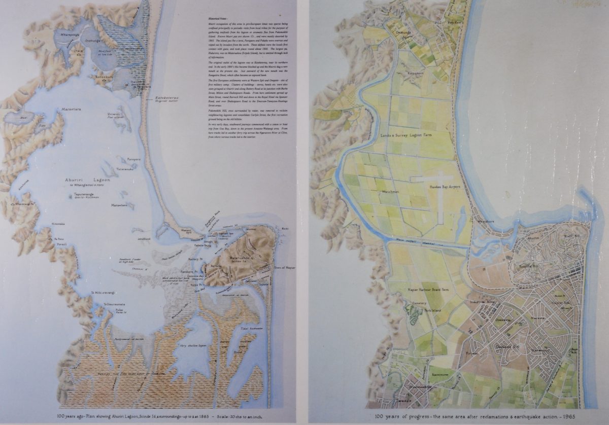
Caption on left-hand map:
100 years ago – Plan showing Ahuriri Lagoon, Scinde Island and surroundings – up to and at 1865 – Scale 20 chains to an inch
Caption on right-hand map:
100 years of progress – the same area after reclamation and earthquake action – 1965
Historical Notes –
Maori occupation of this area in pre-European times was sparse being confined principally to periodic visits from local tribes for the purpose of gathering seafoods from the lagoon or aromatic flax from Pukemokihi Island. Known Maori pas are shown, and were mostly deserted by 1855. The Island pas Iho o terei, Parapara and Pokake were overrun and wiped out by invaders from the north. These defeats were the locals first contact with guns, and took place round about 1820. The largest pa, Hukarere, was on Mataruahou (Scinde Island) , but is omitted through lack of information.
The original outlet of the lagoon was at Keteketerau, near its northern end. In the early 1800’s this became blocked up and the Maoris dug a new mouth at the present site. Just seaward of the new mouth was the Rangatira Shoal, which often became an exposed bank.
The first European settlements were at Western Spit and Onepoto – site of first military camp. Clusters of buildings – stores, hotels etc. were also soon grouped at Ahuriri and along Battery Road at its junction with Burke Street, Milton and Shakespeare Roads. From here settlement spread up Main Street, round Barrack Hill and down to the Royal Hotel via Spenser Road, and over Shakespeare Road to the Emerson-Tennyson-Hastings Street areas.
Pukomatahi Hill, once surrounded by water, was removed to reclaim neighbouring lagoons and consolidate Carlyle Street, the first recreation ground being on the old hillsite.
In very early days, southward journeys commenced with a canoe or bad trip from Goa Bay, down to the present Awatoto-Waitangi area. From here tracks led to another ferry trip across the Ngaruroro River at Clive, from where various tracks led to the interior.
Subjects
Tags
Format of the original
MapAccession number
662/664/34102Supporters and sponsors
We sincerely thank the following businesses and organisations for their support.


Do you know something about this record?
Please note we cannot verify the accuracy of any information posted by the community.