Daily Telegraph 29 December 1980 – Flood issue
The Daily Telegraph
Monday, December 29, 1980
MILLION-DOLLAR TWYFORD FLOOD
STOCK, CROPS SWAMPED BY ROGUE RIVER
Hundreds of head of stock were drowned, crops were ruined and homes had to be evacuated when the swollen Ngaruroro River burst through a stopbank and flooded 1000 hectares of prime agricultural land at Twyford near Hastings yesterday.
The breach in the stopbank, which from a few metres wide quickly became a 70-metre gash, let out a torrent which created havoc as it poured south-east, eventually reaching and closing busy Pakowhai Road.
The Hawke’s Bay Catchment Board relieved the position last night by bringing in bulldozers and cutting a channel alongside the Ngaruroro to divert some of the floodwater into the old riverbed which passes through Clive.
By 7.30am today most roads were reopened and [and] property owners were counting their losses. The area had become a giant lake and losses of stock and crops were expected to be high.
Catchment board deputy engineer Mr David Hamilton said the flooding was the worst in the area for 42 years and the flood appeared to be the third biggest on record.
He estimated the damage would exceed a million dollars once stock, crop and property losses were tallied.
Foundation Weak
He pointed out most of the damage was caused by the Ngaruroro breaching the stopbank.
The break, on the southern bank about 2km from Fernhill, was caused by a weakness in the foundation. Mr Hamilton said there was obviously a sandy bar which let the water through and eroded the foundations.
When the hole in the Clive River stopbank was completed at 11.00pm the floodwaters started dropping rapidly, and at noon today, had gone down by 1.3m.
The breach, which came shortly after 8.00am yesterday, caught residents by surprise and the first they knew of the flood was when they find [found] their houses surrounded by water.
One family at the end of Twyford Road – the worst affected area – escaped via the roof and watched as the force of the water pushed their windows inward.
A recently-wed Wellington woman staying with friends saw her wedding presents floating out of the lounge as the floodwater swept through the house. She and the other occupants had to be taken out by boat.
Fortunately, Twyford is a lightly populated area and about a dozen homes had to be evacuated, although many others were threatened. Horses, jet boats, tractors and heavy trucks were all used to rescue stranded occupants.
Farmers, aided by neighbours and friends, hurried to move their stock to higher ground. But for many it was too late.
One farmer said about 300 of his ewes had “just disappeared” and another calculated about 250 of his sheep and lambs had drowned. Many of the half-drowned sheep plucked from the water could yet die from pneumonia.
Raupare Road identity Mr John Trotter went out with his tractor to help his neighbours, his own property escaping damage.
He took a Daily Telegraph reporter along Evenden, Raupare, Nicholl and Carrick Roads to inspect the stricken area and on the journey they were joined on the tractor by owners trying to get back to their properties.
In Carrick Road, off Nicholl Road, houses owned by Messrs D.R. Grenside, R.O. McLay and K.G. Bainbridge were completely surrounded by water.
Today a distraught Mrs Grenside said the water was 18 inches high in the house. All she had time to get out of the way was dry children’s clothing.
Once cheaply-priced swamp land, the area over the years has been developed to become among the most fertile on the Heretaunga Plains.
It grows a wide diversity of crops – grapes, peaches, kiwi fruit, potatoes, carrots, onion[s], sweetcorn, barley, grass seed, beans and tomatoes.
Mr Trotter believed some of the crops could be saved. “The onions should be all right,” he said. “The tomatoes could recover”.
He said it depended on how quick the water got away and where the sediment came to rest.
Hard luck stories abounded. Mr Rupert Ryan had 50 acres of beetroot due to be harvested today. The crop was lost.
Reports of the flooding attracted large crowds of onlookers and Oak Avenue was barricaded off at Omahu Road and Evenden and Twyford Roads were also blocked off to keep the curious out.
Pakowhai Road was closed from 3.15pm yesterday with Napier-Hastings traffic being forced to use State Highway Two instead when floodwaters spilled across Pakowhai Road between Ellwood and Morley Roads.
It had receded sufficiently to enable the road to be re-opened by 7.30am today but paddocks on both sides of the road were still completely under water.
Waipukurau recorded the heaviest rainfall in Hawke’s Bay for the 48 hours up to 9am today, with a total of 89.5mm. Napier recorded 80mm for the same period, Hastings 72mm, Wairoa 68.9 and Dannevirke 30.2
Not yet out of danger
“We are not out of danger yet.”
That was the warning today from the Hawke’s Bay Catchment Board deputy engineer, Mr David Hamilton, despite the receding floodwaters in the Twyford area.
He pointed out the Meteorogical [Meteorological] Office forecast was for continuing showers this afternoon and evening.
“We will certainly be monitoring things but if the water level comes up there may not be a lot we can do and water will again flow down through Twyford.
“Certainly we would be expecting people in that area who had to move out because of floodwater not to move back in again tonight.”
Mr Hamilton said the board’s attempt to plug the gaping breach in the Ngaruroro River stopbank was only a temporary measure.
If the river continued to rise at the headwaters the river would again flow through the break.
Photo captions –
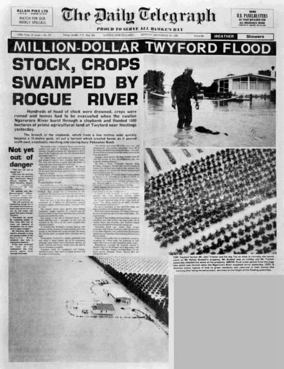
TOP: Twyford farmer Mr John Trotter and his dog Toy on what is normally the tennis court on Mr Hylton Gudsell’s property. Mr Gudsell was on holiday and Mr Trotter yesterday checked the stock on his property.
ABOVE: Fruit trees sprout from the huge lake which was formed when the Ngaruroro River stopbank burst yesterday.
LEFT: A desolate scene, typical of that to greet residents who returned to their homes this morning after being forced to evacuate them at the height of the flooding yesterday.
The Daily Telegraph, Monday, December 29, 1980
Onga Onga – Tikokino area worst hit in CHB
Central and Southern Hawke’s Bay seemed to have escaped the kind of flood damage which struck further north in the Hastings area.
The most serious results of the heavy rain were felt in the Onga Onga-Tikokino district.
Two houses in Swamp Road, near Onga Onga were evacuated after the Waipawa River burst its banks and flooded the area to a depth of one metre.
Nearby, the Waipawa Bridge between Onga Onga and Tikokino had to be closed after a pile dropped about 30cm.
The long one-way bridge is likely to remain closed until the Waipawa District Council can replace the pile.
In the meantime traffic along State Highway 50 is being diverted.
A new bridge is being constructed beside the damaged bridge but is not due for completion until 1983.
Elsewhere in the Waipawa district there were numerous slips and drop-outs but few serious problems.
All other bridges in the district are passable and School Road, Takapau, was the only road still closed early today.
The Waipukurau District Council reported that Hiranui and Middle Roads had been closed but were expected to be reopened today.
There were also a number of minor slips, particularly in the Hautuma [Hatuma] riding.
There was some surface flooding in Waipukurau, the worst being in Coughlan Road.
Carter Holt’s store in Herbert Street was also flooded as was the basement of a house in Holyrood Terrace.
The Dannevirke County Council expected to reopen the Pahiatua Road by lunch-time today although Mangatuna Road, a long time problem, could remain closed for some time.
Elsewhere in the Dannevirke district there were few problems apart from small slips and drop-outs although flooding was reported at the Norsewear industry factory in Norsewood.
Electricity supplies throughout Central Hawke’s Bay were almost completely unaffected by the weather. The exception was Elsthorpe where residents lost power for about an hour yesterday.
Photo captions –
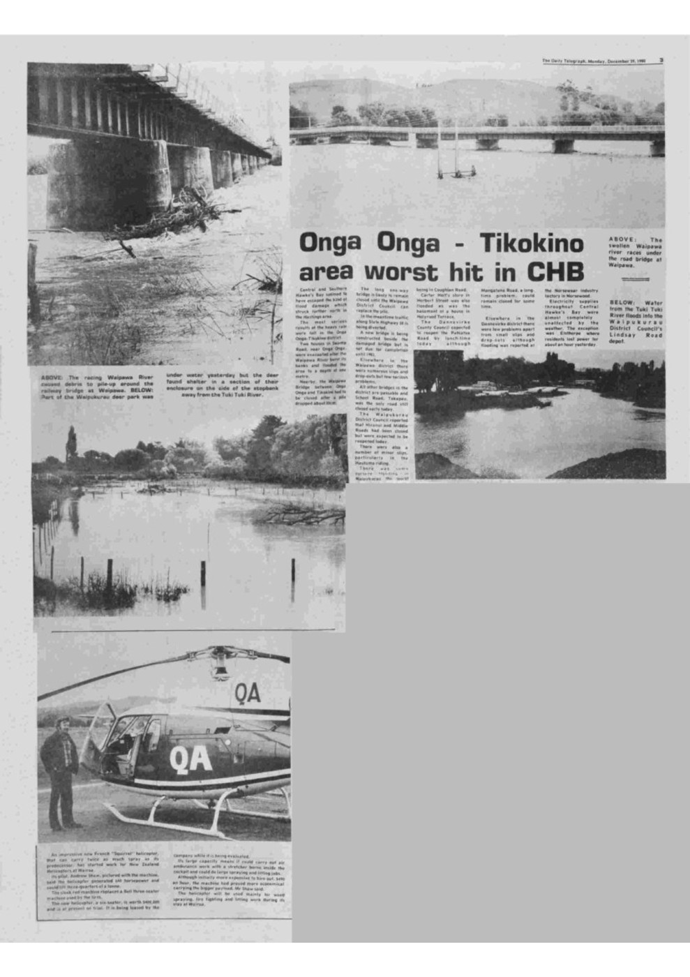
ABOVE: The swollen Waipawa River races under the road bridge at Waipawa.
BELOW: Water from the Tuki Tuki River floods into the Waipukurau District Council’s Lindsay Road depot.
ABOVE (left): The racing Waipawa River caused debris to pile up around the railway bridge at Waipawa.
BELOW (left): Part of the Waipukurau deer park was under water yesterday but the deer found shelter in a section of their enclosure on the side of the stopbank away from the Tuki Tuki River.

Original digital file
GibbsEF1214-2_Newspapers_1980TwyfordFlood.pdf
Non-commercial use

This work is licensed under a Attribution-NonCommercial 3.0 New Zealand (CC BY-NC 3.0 NZ).
Commercial Use
Copyright on this material is owned by Hawke's Bay Today and is not available for commercial use without their consent.Can you help?
The Hawke's Bay Knowledge Bank relies on donations to make this material available. Please consider making a donation towards preserving our local history.
Visit our donations page for more information.
Subjects
Format of the original
Newspaper articleDate published
29 December 1980Publisher
The Daily TelegraphAcknowledgements
Published with permission of Hawke's Bay Today
People
- K G Bainbridge
- D R Grenside
- Hylton Gudsell
- David Hamilton
- R O McLay
- Rupert Ryan
- John Trotter
Accession number
581863Supporters and sponsors
We sincerely thank the following businesses and organisations for their support.


Do you know something about this record?
Please note we cannot verify the accuracy of any information posted by the community.