Hastings City Central Area Replanning 1969

HASTINGS CITY COUNCIL
CITY ENGINEERS’ DEPARTMENT
HASTINGS CITY CENTRAL AREA REPLANNING
INTRODUCTION:
In 1964 representations were made to the Hastings City Council by the Hastings Chamber of Commerce in conjunction with the Hastings Retailer’s Association, urging the Council to consider improvements to the city central area, particularly in respect of the provision of additional parking areas, rear access-ways and the creation of a traffic-free boulevard area in Heretaunga Street extending from Nelson Street to Hastings Street. The plan put forward by the Chamber of Commerce created widespread interest and several further schemes were recommended by others.
Towards the end of 1964 the City Council commissioned Messrs Gabites and Beard, Registered and Chartered Architects and Chartered Town Planning Consultants, to undertake a town planning study of the central business area and to provide the Council with a plan for the future development of the City Central Area.
The report of Messrs Gabites and Beard was received by the City Council and considered at its meeting in November 1965 and adopted in principle. The report with the exception of the appendixes, is reproduced on the pink pages attached.
The City Engineer, was requested by Council to prepare a report on the implementation of the plan in stages. His report recommended some modification of the scheme as prepared by Messrs Gabites and Beard, in particular regarding the proposals to elevate the railway line and this report was discussed by Council at its meeting in December 1965 and adopted in principle, subject to the recommended pedestrian subway under the railway in Heretaunga Street being made as wide as possible and Council further resolved that planning be proceeded with as soon as possible. The City Engineer’s report is also reproduced in full on the blue pages attached.
Steady progress has since been made in the process of implementing the proposals for the redevelopment of the City Central Area. A summary of the actions taken to date and a possible course of action for the further implementation of the plan in stages is outlined in the yellow pages.
SUMMARY OF CONTENTS:
White pages – Introduction
Pink pages – Gabites & Beard Report dated August 1965.
Blue pages – City Engineer’s report dated 6th December 1965.
Yellow pages – Progress Report.
GABITES AND BEARD
REGISTERED AND CHARTERED ARCHITECTS AND CHARTERED TOWN PLANNING CONSULTANTS
THE FUTURE DEVELOPMENT OF HASTINGS CITY CENTRAL AREA.
A TOWN PLANNING STUDY COMMISSIONED BY
THE HASTINGS CITY COUNCIL.
1. Terms of Reference:
In the light of considerable expansion within the City and district in recent years, we have been asked by the Hastings City Council to study the impact of increasing traffic volumes on the future form and functions of the central business area, and to suggest planning measures which could be taken to improve existing conditions and to ensure a safe, convenient and attractive centre for the city of the future.
The detailed implementation of such a programme must, of course, involve much further investigation and consideration by Council and its technical officers before incorporation in a District Scheme under the Town and Country Planning Act, and we have attempted in this study to set out in broad principle only certain techniques of planning which we feel would have a valid application in the future development of the City.
2. Introductory:
Surveys carried out in connection with this study reveal that the business centre is fulfilling its various functions in a relatively satisfactory manner at the present time compared with the central core of many cities of similar size. There is no doubt, however, that certain conditions are emerging which, if not dealt with through a forward-looking planning policy, could lead to serious problems in the future.
While in the past a certain degree of mixing of pedestrian and vehicular traffic, of local and through traffic, and of customer and servicing traffic has been reasonably safe and acceptable in most towns, with rapidly increasing traffic volumes it has now become obvious that fairly costly and drastic measures will be essential in the future to allow city centres to continue to function efficiently. Indeed there are already many overseas examples where delays and frustrations due to traffic congestion have reached such proportions that a process of town centre decline and abandonment has become so far advanced that many traditional functions of the central area have been permanently dispersed to outlying areas, and the centre has deteriorated.

2.
In these extreme cases, the conditions for certain types of shopping and business activity may have been improved by dispersal, but it is now generally recognised, even by the staunchest advocates of planned decentralisation, that a healthy, thriving, convenient and attractive central core is essential to the proper functioning and growth of any town. Emphasis is now being given to the re-vitalisation of central areas as a complement to the development of regional shopping centres, so that one aspect is not allowed to take precedence over another in the overall pattern of expansion.
These factors have been recognised by the City Council in considering the future of this City, and in this study we have endeavoured to suggest practical measures which could be taken to maintain the city centre, provide for its expansion and improve its functioning in the new motor age.
3. Matters Arising from a Survey of Existing Conditions:
(a) Segregation of various types of traffic:
A much higher degree of segregation between vehicles and pedestrians and between local and through traffic will be essential in all future planning. In this connection the proposal to close sections of Heretaunga Street to vehicular traffic appears to be sound and practicable, provided that certain preliminary measures can be undertaken beforehand. When the time is ripe it can be anticipated that the advantages of this complete degree of segregation will be apparent to both businessmen and the public alike, and the transition should be possible with relatively little disruption.
We are making certain other recommendations with regard to traffic routing, parking and service access based on the adoption of this pedestrian precinct principle.
(b) Continuity of Shopping Frontage:
All authorities stress the desirability of achieving the highest possible degree of continuity in shopping frontage in modern commercial centres, and this has become an objective of most town planning schemes.
Continuity of frontage in Hastings is broken in several ways at the present time:
(i) The railway line and adjoining parallel streets on either side. Together these create a gap of over 3 chains in the continuity of the Heretaunga Street shopping area. From this point of view alone some means must be found of removing the railway line and closing this gap in the interests of the commercial area as a whole.
3.
(ii) Breaks in continuity of show windows due to intrusion of offices, banks, hotels and similar uses. Heretaunga Street itself is comparatively free of these uses, but the introduction of a more specific type of commercial zoning for shopping streets would make the position even better over a period.
(iii) Even the breaks due to side streets affect the desirable concentration of frontage, but if certain of these could be converted into pedestrian precincts continuity of verandahs could be achieved across the intersections.
(c) Off-Street Parking:
Greatly increased car ownership, (2.0 persons per vehicle in Hastings urban area 1963 compared with New Zealand average of 2.4 persons per vehicle), and increased use of individual vehicles in recent years, have led to intensive research overseas into the optimum ratio between car parking spaces and the important central area function of retail shopping. It has been found that the success of a shopping area today depends largely on good distribution and close proximity of parking spaces, and, while a potential customer may be prepared to walk quite long distances from his car for certain specialist goods, on an average a resistance begins to develop in most people if they cannot get within 300 yards of a shop. If consistently they cannot park within this distance they begin to seek alternative shopping areas. This figure appears to be fairly constant throughout the world, but 200 yards is quoted by some authorities.
For survey purposes, therefore, only parking spaces situated within 300 yards of the shopping concentration are considered as appertaining to the shopping area, and longer term parking further afield is disregarded. On this basis, in the central area of Hastings at present there is a ratio of approximately 4 car parking spaces per 1,000 sq. ft. of retailing floor space. As a matter of comparison, the ideal standard for future shoping [shopping] centres and the optimum to be aimed at for existing centres as recommended by the New Zealand Retailers’ Federation is 5 car spaces per 1,000 sq. ft. of selling space.
This standard has been applied in our recommendations for future parking in the city centre of Hastings.
As yet a relatively small proportion of the 700 parking spaces available within 300 yards of the shopping area are off the street, but clearly much greater attention will have to be given to this aspect in the face of increased

4.
traffic volumes if congestion is to be avoided. In addition, spaces will have to be found to replace those metered spaces which will be lost on streets converted to pedestrian precincts.
(d) Within central commercial zones the existing ratio of shopping frontage to population may be determined by survey, and estimates of the future frontage requirements arrived at fairly accurately by assuming a constant ratio. At the present time in Hastings central area there is a ratio of 17 feet per 100 persons, and to serve the anticipated population of 55,000 within the planning period a total frontage of 9,150 is planned.
(e) Access to the rear of shop premises for the purpose of loading and unloading goods is rather haphazard at the present time, and although proposed service lanes have already been laid down, what rear access there is in existence is largely by means of a system of private rights-of-way. An extended pattern of service lanes is clearly desirable before the sections of street are closed to vehicular traffic, but the implementation of pedestrian precincts is not entirely dependent on 100% rear access as a number of small specialist shops could be serviced by means of hand trolleys through the front door of the shop.
In certain blocks surface car parks are suggested. The provision of service lanes can be made most economically in conjunction with these areas.
4. Proposals Arising from the Study
(a) Traffic segregation and circulation:
Clearly, the introduction of a series of pedestrian precincts in order to achieve a satisfactory degree of segregation between pedestrians and vehicles raises a few problems of traffic circulation as additional loads are placed on adjoining streets. However, the rectangular grid pattern of the Hastings streets lends itself to the establishment of a ring road or loop to encircle the pedestrian precincts and concentration of shops. Vehicular access to all points within the shopping area is envisaged from this loop, and, in order to allow for increased traffic volumes, one-way traffic is proposed on the loop road itself.
The one-way street system, unsatisfactory in the case of purely shopping streets because it increases the traffic flow without assisting in segregating pedestrians from vehicles, would have a valid application in this case as it would allow for a loop road of considerably greater capacity than a normal two-way road.

5.
Non-stopping through traffic, which is a bugbear in many towns, will be largely removed from Hastings’ streets when the proposed motorway is completed. Until this is built, however, highway traffic will have to be accepted through the central area, and we are suggesting that these proposals be implemented in two main stages, viz: pre-motorway (approx. 0-5 years off) and post-motorway (more than 5 years off). For the sake of convenient presentation of’ the proposals we have assumed that the railway line will be moved at about the same time as the motorway is completed. In the second phase of development as traffic volumes on the loop build up, we are proposing the establishment of a system of outer ring roads. This outer loop would divert a considerable proportion of’ cross-town traffic from the centre and avoid congestion on the inner loop road.
(b) The Railway:
It does not appear to be practicable to divert the railway around the outskirts of Hastings, in a similar manner to the deviation of’ the line around Palmerston North, but its presence in the town centre creates so many problems in the proper functioning of the centre that it is inconceivable that it should be permitted to remain in its present situation indefinitely. Certainly the volume of rail traffic on the line is not great, but the presence of level crossings on busy cross streets is a constant threat to the safety of road users. Further, the physical break through the heart of’ the city centre precludes a satisfactory continuity of land uses on either side, and even leads to uneconomic duplication of some facilities.
If it is accepted, and we feel that it must be, that the solution of the railway line problem is the prerequisite of any long-term planning in the city centre, then there would appear to be only three main alternatives open:
(i) Retain the railway line on its present level and carry vehicular and pedestrian traffic over or under it.
A study was made based on the use of road overbridges on major cross routes and pedestrian underpasses on the Heretaunga Street pedestrian precinct. This proposal allowed good circulation but suffered from the following disadvantages: Firstly, difficult intersections would be created at the foot of the ramps to the overbridges; secondly, the overbridges themselves would be costly and their sheer size would make them difficult to merge satisfactorily into the urban landscape without dominating the scene; thirdly,

6.
a measure of resistance would probably build up in pedestrians at having to take a subway to get across, even when no train was in sight; and fourthly, some break in the desirable continuity of shopping frontage would be inevitable with this proposal.
(ii) Lower the railway line into a cutting sufficiently deep to enable road traffic to be carried across at ground level.
This method would be a major engineering undertaking as it would involve a deep cut with some problems of’ drainage and a disruption of’ existing services. It would also involve a series of’ wide vehicular and pedestrian bridges, and probably a fairly costly underground passenger station, or at least platforms. This system, although costly, would offer many advantages from the viewpoints of aesthetics and traffic circulation and would be worthy of’ consideration were there no other satisfactory alternative.
(iii) Raise the railway line clear of ground level to allow free circulation of traffic beneath it.
This alternative offered many advantages from the circulation point of view, and, provided that it could be carefully designed as part of a comprehensive scheme, few disadvantages. Possible disadvantages were the bulk of the structure necessary to carry the trains, the noise nuisance and general loss of amenity to neighbouring properties.
These factors were carefully studied, and we are suggesting ways in which these drawbacks could be overcome, perhaps not entirely, but at least to a degree which should be acceptable to those who would be most closely affected.
The land occupied by the railway is potentially some of the most valuable in the City. If this potential could be exploited to a maximum and a substantial return obtained from it, it should be economically feasible to develop the land in revenue-producing buildings within which the railway line could be enclosed. A scheme has been prepared in sketch form to illustrate this proposal.
Under this scheme the railway itself could be completely enclosed in an attractive structure, so that problems of noise and unsightly appearance could be entirely overcome. The effect of such a structure on adjoining existing buildings has been carefully,

7.
studied, and, although there would be some loss of outlook, there would be negligible detrimental effect in terms of reduced light and air or even sunlight to occupied rooms.
Within the complex of buildings envisaged in this proposal are a transport centre for ‘buses and taxis integrated with a passenger railway station, car parking on two levels to accommodate 150 vehicles, a department store together with a range of specialist shops to cater for expansion of the retailing area, a vehicle-free civic court in front of the present clock tower and a multi-storey office block.
This is an ambitious proposal, but, over a period, would be well within the economic resources of the community, and, if all aspects can be carefully co-ordinated, would offer the following benefits to the City: Firstly, it would solve the problem of dislocation of’ central area circulation caused at present by the railway; secondly, it would allow for the unification of commercial facilities in the city centre; thirdly, it would allow for an integration of public transport services based on a new railway station; fourthly it would provide for car parking at a most convenient point; and finally it would provide an opportunity for long-term community investment in the future development of’ the City.
In our opinion, however, the acceptability or otherwise of’ lifting the railway would depend on enclosing it. We could not support the proposal to elevate the line if it should mean carrying it on an open structure at high level through the City with consequent detriment to amenity.
(c) Car Parking in the Central Area:
The fruits of considerable research on this problem both at home and overseas are now available to planners. To quote from a recent bulletin of’ the Retailers’ Federation, “Ring roads and a modern central street pattern will not alone suffice to save our town centres from decline. No less essential is the complementary provision of adequate off-street parking space for the vehicles that do have business in their central areas. A town centre gains nothing from the ability of’ motorists to reach it and drive freely about if they cannot get out of’ their cars until they have left it. The demand for parking space is of’ two distinct kinds: that of the town worker who prefers to go to work in his car, parks it throughout the working day, and then drives home

8.
again: and that of the shopper, tourist or travelling businessman who wants to park his car for short periods while he pays visits to shops, restaurants, public buildings or offices. The accommodation of the all-day parker’s car contributes nothing to the well-being of the town centre: without it he would simply have to travel by public transport. The accommodation of the short-period parker’s car on the other hand, is in most cases vital to the well-being of the town centre – without it he would stay away and take his business elsewhere”.
We have been influenced by these principles in our studies in Hastings, and have given particular emphasis to the provision of adequate short-term parking within a striking distance of 300 yards from some part of the commercial centre.
We have accepted the ideal standard of 5 car spaces, per 1,000 sq.ft of retail floor space for short-term parking as a planning objective at all stages in the central area development, and have based our studies on consideration of various methods of providing for a total of approximately 1,600 cars in off-streets parks to meet ultimate needs.
Block-by-block studies have been made to compare to relative costs of ground-level parking in each block with parking buildings at strategic intervals.
In view of the high cost of parking buildings (we have assumed a figure of £800 per space) there is no doubt that the acquisition of sites and the demolition of buildings within commercial blocks to provide ground level parks offers a much cheaper alternative. (Ranging from £160 to £666 per space). A study based on this principle allowed for a full-scale of ground level parking well distributed within the inner loop of the commercial area for an estimated £476,400. This study also provided for a full range service lane facilities to all blocks.
Alternative studies based on more limited site acquisition and greater number of spaces in parking buildings, still within the loop, resulted in an even more astronomical theoretical total of £727,400.
Thus, it seems obvious to us that any attempt to provide the required range of off-street parking facilities entirely within the inner ring road would be unacceptable on the grounds of cost, interference with legitimate existing uses and general sacrifice of quality in the town centre environment.
Our proposals to overcome these obstacles, assuming that 150 spaces can be provided as part of the railway raising project, are based, firstly, on the acquisition of ground

9.
level parks within the loop only up to an arbitary [arbitrary] limit of £300 par car space; secondly, the acquisition of further ground level parks on relatively cheaper land immediately outside the loop; and thirdly, on increasing car parking capacity during the second phase of development by the erection or a limited number of parking buildings over surface parks as the demand arises.
On this basis, assuming also a considerable amount of continued kerbside parking in the first phase of development, land acquisition costs can be reduced to manageable proportions and the major task or providing approximately 500 car spaces in parking buildings can be undertaken during the second phase or development when the City will have grown in population and resources.
(d) Land Use Zoning In Central Area:
As previously mentioned, the present commercial area is fairly compact, but the proper functioning of the retailing area is somewhat affected by an admixture of uses such as hotels, banks and offices which create breaks in the continuity of shop frontage.
Such uses are, of course, both necessary and desirable within the city centre, but there is a growing tendency for councils to allow them in the main shopping streets only if they are prepared to provide continuity or display space across the site frontages. Specific ordinances may be introduced under the District Scheme to ensure this continuity, and we attach a typical prescription of uses for such a zone as Appendix A.
We would recommend that all commercial land situated within the inner loop be zoned in this special Commercial B1 zoning.
(e) The Cost of Implementing the Proposals:
The cost of planning central city areas to meet the needs of the motor vehicle is something which is confronting communities today all over the western world.
Professor Colin Buchanan, whose studies in this field have won universal acclaim, has this to say about the enormous cost of providing proper facilities for the handling of urban traffic:
“An authority which takes cheapness as the criterion of its planning must also accept that the local community will not be able to make full use of motor vehicles, and there will be a consequent risk of losing business to some nearby locality with better standards.
The choice will be either to match the investment in vehicles with an equivalent investment in works, or to

10.
invest less in works and curtail the usage of vehicles.”
A town of 37,000 population in the U.K. which was the subject of a special study by Professor Buchanan is faced with the expenditure of £4 ½ million to bring its roading network up to a desirable standard.
By comparison, the traffic problems of Hastings are on a considerably smaller scale, and ways of providing acceptable standards with a minimum of expenditure have been suggested in this report. There can be no doubt, however, that the maintenance and development of a vital, pleasant and convenient city centre will require considerably greater sums of money in the future than have been necessary or available in the past.
5. Summary of Recommendations:
Briefly, we would summarise our recommendations as follows:
(a) That steps be taken to obtain Government agreement to the elevation of’ the railway line in accordance with a fully developed and comprehensive scheme along the lines proposed in this study, to provide for an integrated transport centre, additional shopping, parking and office space.
(b) That steps be taken to designate reserves for future parking and service lanes where required in the central area and to embark on an acquisition programme.
(c) That preliminary detailed planning be commenced to enable pedestrian precincts and the one-way inner loop to be established at the earliest possible time.
(d) That ordinances for a more specific commercial zone within the proposed inner loop road be introduced into the District Scheme.
GABITES AND BEARD. (Sgnd)

HASTINGS CITY COUNCIL
REPORT FROM THE CITY ENGINEER
CENTRAL AREA REPLANNING
The report of Messrs Gabites and Beard on the future development of the central city area concluded with the following recommendations:
(a) That steps be taken to obtain Government agreement to the elevation of the railway line in accordance with a fully developed and comprehensive scheme along the lines proposed in this study, to provide for an integrated transport centre, additional shopping, parking and office space.
(b) That steps be taken to designate reserves for future parking and service lanes where required in the central area and to embark on an acquisition programme.
(c) That preliminary detailed planning be commenced to enable pedestrian precincts and the one-way inner loop to be established at the earliest possible time.
(d) That ordinances for a more specific zone within the proposed inner loop road be introduced into the District Scheme.
The conclusions of the study were made on the understanding that the railway through the centre of the city would be elevated between Southampton Street and St Aubyn Street and that it would be enclosed to avoid consequent detriment to amenity if it were an open structure.
The Railways Department was asked to comment generally on the proposal for elevating the railway and moving the station and to give some estimate of the probable cost of the work. The District Engineer, Railways Department states that the probable cost of the work would be between £1,250,000 and £1,500,000.
Approach grades would be 1 in 100 with six-chain vertical curves making the end ramps each about 2500 feet long. To the south the ramp would start about opposite the south of the Boys’ High School buildings and to the north it would start at Heathcote Avenue. The northern ramp would interfere with the tracks leading to the railway marshalling yards. Clearance over roadways would be 16 feet and a similar clearance would be required over railway tracks.
The Department has had no experience of sound-proofing of an elevated track and has no recommendation to make. The services of a specialist consultant would probably be required to advise on this aspect of the work. Any form of suitable sheathing round the elevated track other than concrete would probably cause noise and vibration that would be unsatisfactory both to rail passengers and the occupiers of nearby premises.
In general, the elevation of the railway would be of no advantage to the Department and it would necessitate considerable expenditure by them at the goods yard.
No financial assistance from the Railways Department could therefore be anticipated.
The total height of the enclosed rail structure would be 37 feet made up as follows:
Road clearance 16′-0″
Beams, decking, ballast and rails 4′-0″
Rail clearance 16′-0″
Top structure 1′-0″
Total height 37′-0″

Such a structure would be
(a) About two-thirds the height of the clock tower, the top being about 10 feet below the clock face.
(b) 9 feet above the parapet of Westerman’s building.
(c) 4’6″ above the parapet of the Post Office.
(d) 8 feet above the parapet of the Municipal Buildings.
If a loan were raised to finance this work, the annual charges would be of the order of £100,000 per annum and this item alone would increase rates about 35%.
The structure would be carried on reinforced concrete piers and the top 21 feet would be enclosed. It is difficult to see how any pleasing form of architectural treatment could be devised that would prevent disharmony in the area from being created.
It is appreciated that the expenditure of a considerable sum of money would be warranted to seprate [separate] rail and road traffic in the centre of the city and that benefits would increase with further city development and increased traffic. On the other hand, it is very important that architectural disharmony should not be created in the area where it appears most important that an attractive setting should be developed.
In general, problems of rear access to premises and the parking of vehicles that would require solution before existing streets could be converted to pedestrian precincts are not greatly affected by the elevation of the railway.
Some thought has therefore been given to the manner in which pedestrian precincts could be established and to the traffic problems that would result if the railway remained in its present position.
General traffic problems also require consideration.
Future expansion of Hastings in the Flaxmere area has been planned to preserve for agriculture as much as possible of the highly fertile areas surround the city in all other directions.
A modern shopping centre and several small local shopping areas are planned in Flaxmere when a population of 10,000 people is expected within ten years and it is anticipated that most of the day-to-day shopping will be done there where ample car-parking facilities will be available. The largest industrial area in the city is also located in Flaxmere.
There is no suggestion that the main business centre of Hastings will not remain in its present location or that it will not expand to meet future business requirements but if the outward expansion of Hastings is restricted except torwards [towards] Flaxmere and if the bulk of new industries are also located in that direction, the increase in vehicles using the central area will not be in the same proportion as the increase in the city population. Even with this reservation, a substantial increase in vehicles using the central area can be anticipated.
Regarding rail traffic, it is understood that there are 14 train crossings per day between the hours of 5 am and 7 pm and 9 during night hours. Eight of these would be for railcars where road vehicle delay at a crossing would be about the same as at lightcontrolled intersections.
Plan No 1168 has been prepared on the assumption that the railway through the centre of the city is not elevated but that it is move about 10 feet to the east where possible.
The following streets are shown as pedestrian precincts where vehicle traffic would be prohibited:

Heretaunga St Karamu Rd to Market St
Russell St Queen St to Eastbourne St
Part of the area opposite the present bus terminus
The following streets are shown with partial restrictions on entry and exit in which angle parking would be permitted but “through” traffic would not be allowed:
Heretaunga St Nelson St to Market St
King St Queen St to Eastbourne St
Heretaunga St Karamu Rd to Hastings St
Warren St Queen St to Eastbourne St
Russell St Eastbourne St to Lyndon Rd
There would be one-way traffic in the following streets:
Queen St Nelson St to Hastings St
Eastbourne St Nelson St to Hastings St
Railway road would be closed between Eastbourne Street and Heretaunga Street except for a cul-de-sac in which parking would be prohibited, giving access both to Messrs Newman Bros. bus depot and to the Hastings Hotel.
Two-way traffic would be permitted on all other streets.
The railway line at Heretaunga Street would be completely isolated and pedestrians would use a subway.
New traffic lights would be required at the following intersections:
Karamu Rd & Queen St
Karamu Rd & Eastbourne St
Market St & Queen St
Market St & Eastbourne St
Traffic lights would be removed from the following intersections:
Heretaunga St & Russell St
Heretaunga St & Railway Rd
Heretaunga St & King St
It is essential that rear access and facilities for parking cars within a reasonable distance should be provided for premises having a frontage to a pedestrian precinct although the delivery of’ goods of a light nature by trolley along the precinct would not create a problem except during very busy periods.
Of the four central city blocks, a major extension of rights-of-way would be required in only one. Negotiations for improved rear access could be involved and protracted and it is therefore suggested that, in the first instance, the pedestrian precincts be limited to those shown with provision for their extension at a later date as required.
Trade vehicles could use those streets shown with angle parking for the delivery of goods until rear access to adjoining blocks had been put in order.
The scheme as suggested would remove “through” traffic from most of’ the central shopping area particularly in an east-west direction without seriously interfering with the general flow of traffic in the city.
After allowing for the loss of parking space on streets closed to vehicles, there would be a nett gain of about 75 car parking spaces if angle parking were permitted as shown.
With the demolition of the old railway goods shed the whole of

the old goods yard has now become available for some form of development.
An area for shops on part of the Queen Street frontage is shown but the whole of the balance of the area is suggested for car parking with entry and exit from Market Street only but with foot access to Queen Street. Suitable beautifcation [beautification] along the Market Street, St Aubyn Street and Queen Street frontages could be carried out.
It is recommended that the Railways Department be approached with the suggestion that the whole of the old railway goods yard shown for parking should be enclosed, metalled and sealed and marked out in parking bays by the Department, that the area be controlled by Council (with attendant) and that all revenue obtained after paying all supervision and attendants costs should go to the Railways Department. The Council lease of part of the area would then not be required.
This car park could accommodate about 270 vehicles.
Bus traffic would have to be excluded from the central city block and stopping places in Eastbourne Street and Queen Street near the Railway Line are shown.
In the area forming an extension to Railway Road, buildings could be erected partly on Railway land and partly on land owned by Council. An arcade 25 feet wide is shown and this could be completely covered between Heretaunga Street and Queen Street.
The new buildings could be erected up to the Heretaunga Street frontage with a verandah extending across the arcade and across Heretaunga Street at the end of pedestrian subway but at Queen Street buildings would have to be set back from the railway crossing to provide visibility.
A verandah could also be built across Heretaunga Street to give protection at the eastern end of the subway.
Detailed consideration has not yet been given to the many problems that would be created by the closing of certain streets in the central city area to vehicular traffic.
The most important matter to be resolved now is the level at which the railway is to pass through the centre of the city and then the extent of the proposed pedestrian precinct. Some estimation of the probable cost of the work would then be possible.
At this stage the co-operation and approval of property-owners in the central city area is essential in order that the scheme can proceed with the support of all parties concerned.
R.P. FISH. M.I.C.E. (Sgnd).
CITY ENGINEER.
6th December, 1965.

HASTINGS CITY COUNCIL
CITY ENGINEER’S DEPARTMENT
CITY CENTRAL AREA REPLANNING – PROGRESS REPORT
Since the adoption by Council of the Gabites and Beard report and the City Engineer’s report in 1964 steady progress has been made with the implementation of the scheme although this may not be immediately apparent superficially.
In order to appreciate the actions taken by Council to date, reference is made to plan No 1328 and the main features of’ the scheme which are:-
(a) The streets within the four central city blocks are to be transformed into a pedestrian precinct.
(b) The streets within the outer 8 city blocks, i.e. between Market Street and Nelson Street and between Karamu Road and Hastings Street are to be transformed into “parking streets”, with one-way traffic, parellel [parallel] parking to one side and angle parking to the other side.
(c) A “ring road” is to be formed by transforming Queen Street Hastings Street – Eastbourne Street – Nelson Street into one-way traffic streets to allow through traffic to pass the city centre and to improve the circulation of’ traffic between the major city blocks. Market Street and Karamu Road will remain open for two-way traffic.
(d) The provision of’ adequate rear access to business premises.
(e) The provision of’ additional facilities for off’-street parking of cars within reasonable distance of retail shops.
These features of the scheme are not necessarily in order of’ importance or sequence and others can be added to the list.
Actions taken to date-
The actions taken to date by Council are all preliminary to the implementation of the scheme as a whole and include-
(i) Provision of’ additional parking facilities.
(ii) Steps taken to ensure the provision of rear access to properties.
(iii) Improvements to roads and footpaths.
(iv) Investigations of traffic flow.
Car Parking –
Since 1964 the Council has come to an agreement with the Railways Department for the conversion of the old goods yards to a car parking area. Part of the area was tar-sealed with provision for 185 off-street car parking spaces and the sealed area can be extended to provide for a total of’ 275 car parking spaces.
Russell Street between Eastbourne Street and Lyndon Road was closed to through traffic, widened and transformed into an area for 68 short term car parking spaces, while it is intended to convert Warren Street between Eastbourne Street and Lyndon Road in similar manner for 66 parking spaces.
Owners of’ six properties in Nelson Street between Eastbourne Street and Lyndon Road have been advised of Council’s intention to rezone their land for carparking at the next review of the Town Plan. It is intended that Nelson Street be closed between Lyndon Road and Eastbourne Street and an off-street car parking area be formed for 296 cars.
Similarly the owners of’ a block of land at the intersection of Hastings Street and Avenue Road, Donovan’s Coal Yard, have been advised that their land will be zoned for parking to provide for 61 off-street car parking spaces.

All of the above properties will be purchased by Council as and when they become available or sooner when required for carparking areas.
In addition to the 766 off-street car parking spaces constructed or planned by the Council, business firms in the central city area have since 1964 provided another 546 off-street parking spaces for customers; this includes Woolworth’s car park in Avenue Road for 132 spaces.
Rear Access –
The provision of adequate rear access to business properties is a prime requisite to the implementation of’ the scheme. Without adequate rear-access to shops, no streets can be closed to traffic to form the pedestrian precinct, while in the “parking streets” the free flow of traffic will be impeded by parked trade vehicles.
In order to keep owners of properties informed during the planning stage of’ this aspect of the scheme, meetings were arranged in succession to which the property owners of seven city blocks were invited. At each of these meetings the proposals for improvement of existing rights-of-way or the laying-off of new rights-of-way were explained and discussed in detail.
The stage has now been reached that the proposals for rear access are being consolidated and together with the proposed pedestrian precinct scheme will be put forward as an amendment to the Hastings District Planning Scheme.
Roads and Footpaths –
Improvements have been made to existing streets and footpaths. The deep water channels have been reconstructed in a number of’ streets in the city centre and this work will continue in the present financial year. It is imperative that, in particular, the ring roads are brought to a high standard of’ finish before all traffic from Heretaunga Street is diverted to them.
Traffic flows –
Traffic tallies were taken on all streets in the city centre in order to determine the effect on traffic flow when the scheme is implemented, and the assistance of’ the traffic engineers of the Road Transport Division of the Ministry of Transport has been much appreciated in this work. The existing flow of traffic during Friday peak periods was assigned to the one-way street system and the findings are that the system as proposed will be reasonably adequate for present day flows, but traffic increases and through traffic will require further consideration. The transportation survey now commenced, will help in determining what actions will be needed for future traffic.
Final Implementation of’ Plan –
The implementation of’ the pedestrian precinct plan as a whole will cause major alterations to the movement of all traffic in the city centre. Many habits of’ driving, parking and shopping will need to be changed and some initial confusion may be inevitable although with good publicity this can be reduced to a minimum. The complete change-over does not need to be done at the one time and can be arranged in stages including the following steps-
(i) The adoption of the amendment to the district scheme plan. This is a necessary first step which will make it possible for Council to convert streets into “Pedestrian Malls” under section 170 A of’ the Municipal Corporations Amendment Act 1968. This includes also approval by the National Roads Board in respect of’ relocation of part of’ S.H.2. through Hastings.
(ii) The improvements to rear-access into business premises. The early co-operation and action by the owners and/or occupiers of properties is essential, as the benefit of the

other improvements can be largely nullified by parked trade vehicles in the streets. The recommended width of rear-access ways is 20 feet to allow 2-way movement and facilities for loading and unloading are to be provided on the properties.
(iii) The formation of the outer ring road with one-way traffic.
This includes the erection of’ new traffic lights which will be linked to a master controller. The routes of’ public transport busses [buses] will at this stage need to be re-directed and new bus stops provided.
(iv) The formation of the outer “parking streets”. This will force all through traffic out of Heretaunga Street into the outer ring road, and provides for approximately 125 additional car parking spaces.
(v) The formation of’ the pedestrian precinct. This is the most complex part or the scheme and includes the partial shifting of the railway line, the construction of a pedestrian underpass under the railway line, reconstruction of all paving suitable for pedestrian traffic, the construction of’ a shopping arcade with new buildings in Railway Road Extension (between Heretaunga Street and Queen Street), re-location of taxi stands and furnishing the area with seats, planting etc. This programme will require time and money and can also be carried out in stages with possibly closing Heretaunga Street between Karamu Road and Russell Street and between Railway Road and Market Street as the first step.
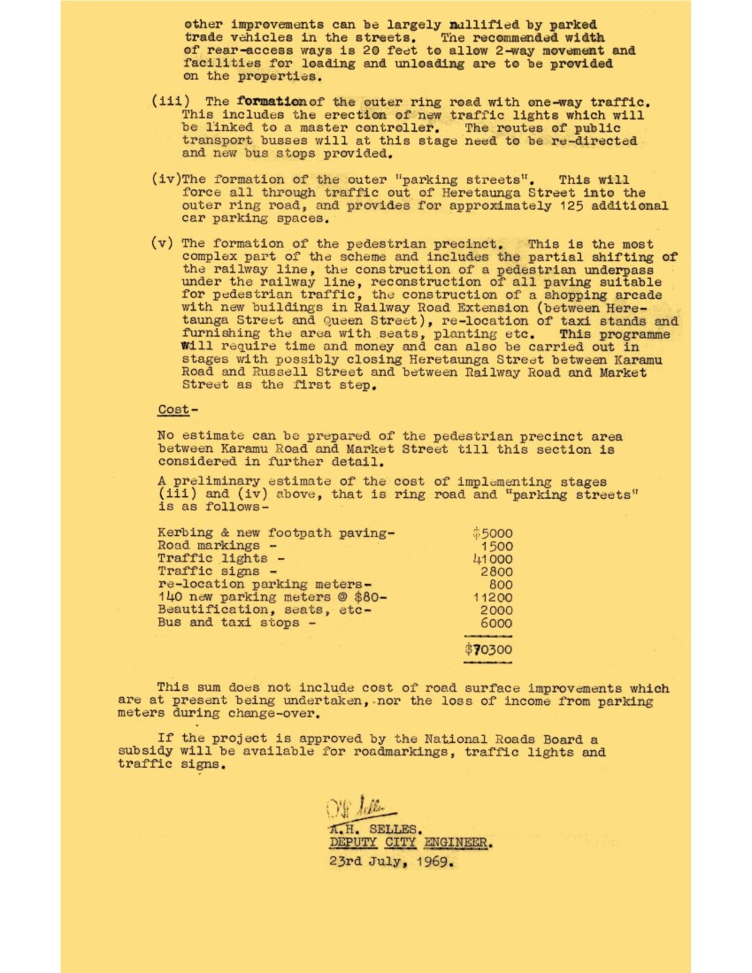
Cost –
No estimate can be prepared of’ the pedestrian precinct area between Karamu Road and Market Street till this section is considered in further detail.
A preliminary estimate of’ the cost of’ implementing stages (iii) and (iv) above, that is ring road and “parking streets” is as follows-
Kerbing & new footpath paving – $5000
Road markings – 1500
Traffic lights – 41000
Traffic signs – 2800
re-location parking meters – 800
140 new parking meters @ $80 – 11200
Beautification, seats, etc 2000
Bus and taxi stops – 6000
$70300
This sum does not include cost of road surface improvements which are at present being undertaken, nor the loss of income from parking meters during change-over.
If the project is approved by the National Roads Board a subsidy will be available for roadmarkings, traffic lights and traffic signs.
A.H. SELLES.
DEPUTY CITY ENGINEER.
23rd July, 1969.

Original digital file
PoppelwellMD877_Replanning.pdf
Non-commercial use

This work is licensed under a Attribution-NonCommercial 3.0 New Zealand (CC BY-NC 3.0 NZ).
Commercial Use
Please contact us for information about using this material commercially.Can you help?
The Hawke's Bay Knowledge Bank relies on donations to make this material available. Please consider making a donation towards preserving our local history.
Visit our donations page for more information.
Description
Subjects
Business / Organisation
Hastings City CouncilFormat of the original
Typed documentDate published
23 July 1969Accession number
624230Supporters and sponsors
We sincerely thank the following businesses and organisations for their support.


Do you know something about this record?
Please note we cannot verify the accuracy of any information posted by the community.