History of Hawke’s Bay

GROUP OF VISITORS AT THE RESIDENCE OF THE HON. H. R. RUSSELL, MT. HERBERT, FEBRUARY, 1876.”
FRONT ROW: (1) Mr. Henderson (cadet at Forest Gate), (2) Miss Herbert, (3) Sydney Johnston, (4) Miss Porter, (5) Colonel Herrick, (6) Colonel (later Major-General) Whitmore, (7) Stuart Bridge (still alive – 1939).
BACK ROW from left to right): (1) Mr. Ashcroft, (3) Mrs. Ashcroft, (3) Mrs. Napier-Bell, (4) Miss Lambert, (5) Mrs. Herrick, (6) Mrs. Spencer, (7) Hon. H. R. Russell, (8) Miss Lambert.

Wholly Set Up and Printed in New Zealand
By Wright and Carman Ltd.,
177 Vivian Street, Wellington,
And Bound by John Dickinson and Co. (N.Z.) Ltd.
Wellington,
For A. H. and A. W. Reed,
Publishers,
33 Jetty Street, Dunedin, and
182 Wakefield Street, Wellington.
London: G. T. Foulis & Co Ltd.,
Australia: S. John Bacon, Melbourne,
1939
FOREWORD.
In this Centennial year it is fitting that we should turn back and look at the past. To Hawke’s Bay the occasion has come as an opportunity to do what had not properly been done before – to produce a comprehensive history of the whole Province.
If this volume has successfully fulfilled that function, it has been due to the unstinted labours and careful research of the members of the Hawke’s Bay Centennial Historical Committee.
This body was formed on 27th October, 1937, at a general meeting, as a Committee of the Hawke’s Bay Provincial Centennial Council, and it was decided that it should produce this history as a Centennial Memorial for all Hawke’s Bay, the various local bodies thereof contributing the required funds.
Thanks are above all due to Mr. J. G. Wilson, whose masterly history, mainly of the early days, was acquired for the use of the Committee, and Mr. W. T. Prentice, who contributed the unique and valuable Maori section. Thanks are due also to Mr. Russell Duncan, for his interesting article on Early Days at the Port of Napier; Mr. C. L. Thomas, for his pretty little piece on Pukemokimoki, the hill of the sweet-scented fern; Mr H. Guthrie-Smith, for his valuable Introduction; Messrs. John Williamson and James Hislop, for the very able and comprehensive Educational section, and the latter for his excellent Military section; Rev. Father Riordon, for his assistance in the Roman Catholic portions of the Ecclesiastical and Educational sections; to Mr. W. T. Chaplin, for his careful checking of the Hastings account; Mr. T. Lambert for his special Centennial history of Wairoa, on
HISTORY OF HAWKE’S BAY.
which the necessarily brief account given is based; to Mr H. A. Henderson for the use of his thesis on Southern Hawke’s Bay; to the Secretary, Mr A. M. Isdale, for the work of typing and editing, under the supervision of Messrs. Wilson and Price as Co-Editors, and for the article on Settlements on the Puketitiri Road, prepared largely from information supplied by Mrs. F. Hutchinson of Rissington; and especially to Mr. C. Price, to whose indefatigable labours are due the following: – In the Days of the Bullock Waggons, Old Coaching Days, Napier Harbour, Shipwrecks, Napier (except Mrs. Dunlop’s Narrative, contributed by Mr. Wilson), Hastings, Taradale, Sports and a description of the 1931 Earthquake appended to Mr. Wilson’s general article on Earthquakes.
And, furthermore, our most earnest and grateful thanks are due to the unnamed many who have provided materials and assistance towards the shaping of this work.
May it be found worthy of these efforts and of the Province of Hawke’s Bay.
J. A. ASHER,
Chairman.
Napier,
7th September, 1939.
CONTENTS.
INTRODUCTION 9
PART I – THE MAORI HISTORY OF HAWKE’S BAY.
PREFACE 19
I COMING OF TOI. (Rongokako, Kahungunu) 21
II THE INVASION OF HAWKE’S BAY BY THE NGATI-KOHUNGUNU (Turupuru, Taraia’s Raids on Heretaunga) 31
III KAHUTAPERE 47
IV TU AHURIRI 57
V TE WHATUIAPITI 64
VI TE WHEAO PA 73
VII RAIDS AND MIGRATION TO NUKUTURUA (MAHIA) 85
VIII THE LAST FIGHTS IN HAWKE’S BAY 98
PART II – EARLY HAWKE’S BAY.
INTRODUCTION 113
I DISCOVERY OF HAWKE’S BAY 115
II THE DAYS BEFORE ORGANISED SETTLEMENT. (Whalers, Traders, etc. The Explorers and Early Visitors. The Early Missionaries.) 135
Contents – Continued.
Chapter. Page.
III THE COMING OF THE SETTLER. (Origins and Conditions. Maori and Pakeha. Progress of Settlement. In the Days of the Squatter. The First Sheep in Hawke’s Bay, With the Founding of Pourerere Station and Various First Hand Accounts of the Experiences of the Pioneers.) 192
IV TOWNS AND SETTLEMENTS. (The Country Townships. Country Districts and Settlements. Settlements on the Puketitiri Road. Early Residents of Westshore and Petane and the First Township. The Scandinavian Settlements and Woodville.) 264
V ROADS AND COMMUNICATIONS. (By Road and Rail. By Water. By Air. Post and Telegraph.) 324
VI INDUSTRIAL AND COMMERCIAL. (Trade. Industries of Hawke’s Bay. Local Taxation in Hawke’s Bay in 1865.) 368
VII GOVERNMENTAL. (Provincial Government. County System.) 380
VIII VARIOUS. (Our Noted Men. Some Stories.) 386
IX TE AUTE COLLEGE AND ESTATE 390
PART III – NAPIER, HASTINGS, WAIROA AND SPECIAL SECTIONS.
I NAPIER AND SUBURBS. (Napier. Taradale and Greenmeadows. Other Suburbs) 407
II HASTINGS 421
III WAIROA 428
IV VARIOUS. Education. Ecclesiastical. Military Section. Napier Musical and Dramatic. Sports. Earthquakes in Hawke’s Bay.) 433
CHRONOLOGICAL SUMMARY 453
BIBLIOGRAPHY 455
INDEX 458
LIST OF ILLUSTRATIONS.
Group of Visitors at Mt. Herbert, 1876 Frontispiece
Relief Map of Hawke’s Bay (1864) Facing Page 16
Map of Port of Napier, 1855 98
Old Pa Posts on Gwavas, near Tikokino 99
Te Hapuku, Paramount Chief of Hawke’s Bay 99
Noah, Native Chief of Pakowhai 99
Rev. William Colenso, First Resident Missionary at Ahuriri 99
Woburn (Hatuma) Outstation, 1860 114
Mr. J. G. Wilson’s Modern Residence – The Author’s Home 114
Hawke’s Bay Coat of Arms 146
Mrs. Roe, nee McKain, Writer of Westshore History 146
Alexander Alexander, First Permanent Trader, 1846 147
Mrs. J. B. McKain and Two Daughters, taken 1875 147
Mount Vernon Homestead, about 1856 162
Forest Gate Homestead, J. R. Duncan, built 1857 162
Bishop William Williams, First Bishop of Waiapu 163
Thomas Lowry, Pioneer Sheepfarmer, arrived 1851 163
C. H. Weber, Civil Engineer, arrived 1860 163
G. T. Fannin, Clerk Provincial Council, 1858-76 163
Sir William Russell’s Homestead, “Tunanui,” 1862 194
Captain Anderson’s Residence, “Omatua,” 1862 194
Sir Donald McLean, Land Purchase Commissioner, etc 195
List of Illustrations – Continued.
Hon. J. D. Ormond, Superintendent Province, 1869-76 Facing Page 195
Mr. Mason Chambers’ Modern Residence, built 1915 210
Waipawamate Stockade, erected in early 60’s 211
Sketch of Omarunui Engagement, 1866 211
Waipawa Town, 1874 274
Hampden (Tikokino) Blockhouse, completed 1865-6 275
Onepoto Military Camp, 1859 290
Tennyson Street, Napier, 1860 290
Gore-Browne Barracks, Napier, taken 1863 291
Deviations on Titiokura Hill, taken 1915 338
Taupo Five Horse Coach, taken 1909 339
G. E. G. Richardson, Shipowner, arrived 1857 354
Inner Harbour, Port Ahuriri, taken in the 80’s 355
Rev. J. A. Asher, Presbyterian Minister St. Paul’s, 36 years, Chairman Hawke’s Bay Centennial Historical Committee 402
Napier Town, 1864 403
Early Napier, date not known 418
Removing Pukemokimoki Hill, 1872 418
Napier, showing Napier South before Reclamation 419
William Marshall, Napier’s First Schoolmaster, began 1855 434
Dr. Thos. Hitchings, Napier’s First Medical Man, arrived about 1856 434
First Buggy in Hawke’s Bay, imported by Father Reignier, taken about 1888 434
Hastings Town, 1886 435
Veterans’ Reunion, 1913 – survivors of 1863 450
Hastings from the Air, 1939 451
Maps – General Locality; Native Land Purchases; Inner Harbour and Rivers on Heretaunga Plains, 1864, and The Same To-day Inside Front Cover
Genealogical Key to Maori Section Inside Back Cover
Page 9
INTRODUCTION.
CLIMATE: Hawke’s Bay has a Mediterranean climate – warm, dry summers, cool, moist winters – with a tendency to summer droughts and occasional phenomenal cloudbursts of tropical intensity, causing at times severe floods. In 1924, 16 ½ inches of rain fell at Eskdale in nine hours.
BOUNDARIES: The Hawke’s Bay Provincial District is bounded on the north by the 39th parallel; on the west by the watershed of the main range, which passes under various names as noted below, to the Manawatu Gorge; to the south by the Manawatu river to the mouth of the Tiroumea stream, and then in a straight line running eastwards to the mouth of the Waimata creek, on the coast a few miles south of Cape Turnagain.
STRUCTURAL AND SOIL: Hawke’s Bay consists of: (a) Western Range (from south: Ruahines, Kaimanawas, Kawekas and Mangahararus) and its foothills (as Wakararas and Birch Range). Composed largely of grey-wacke, from which our river shingle and possibly gravel conglomerates are derived, this chain ranges from 3,000 to 4,000 feet high. The highest point is about 5,000 feet. (b) Middle Valley, apparently an earth-fold or “structural valley,” which continues the line of the Wairarapa Valley from the Gorge as the Manawatu basin (a hilly basin much broken by deep valleys), the extensive Takapau-Ruataniwha plains (an old lake bed), and the Te Aute valley (divided in two by the Te Aute hill), coming out by Paki Paki to end in the Heretaunga Plains and Hawke Bay. Mainly gravel and silt. (c) Coastal Hills. From the Puketoi Hills a low limestone and papa range with no special name except, behind Havelock North, “Havelock Hills,” goes
Page 10
HISTORY OF HAWKE’S BAY.
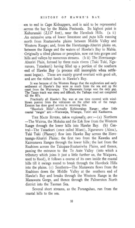
on to end in Cape Kidnappers, and is said to be represented across the bay by the Mahia Peninsula. Its highest point is Kahuranaki (2,117 feet), near the Havelock Hills. (a ii) An extensive area of lower limestone and papa hills running north from Ruataniwha plains between Middle Valley and Western Range; and, from the Heretaunga-Ahuriri plains on, between the Range and the waters of Hawke’s Bay to Mahia. Originally a tilted plateau or peneplain, now cut into gorges and hills and valleys by numerous streams. (b ii) The Heretaunga-Ahuriri Plain, formed by three main rivers (Tuki Tuki, Ngaruroro, Tutaekuri) having filled up a portion of the southern end of Hawke Bay (a process still incomplete when settlement began). These are mainly gravel overlaid with good silt, and are the richest lands in Hawke’s Bay.
It was because of the Western Range that the exploration and early settlement of Hawke’s Bay were so much from the sea and up the coast from the Wairarapa. The Manawatu Gorge was the only gap. The Taupo track was steep and difficult, the Taihape road not completed till the 80’s.
Practically all Hawke’s Bay was at one time covered with wind-blown pumice from the volcanoes on the other side of the range. Erosion has done good service in removing this.
“Havelock Hills” – Actually Kohinurakau Range; other little coastal “ranges” are”- Waewaepa, Whangai, Tutiri and Kaokaoroa.
THE MAIN RIVERS, taken regionally, are: – (a) Northern – The Wairoa, the Mohaka and the Esk flow from the Western Range through the lower hills into Hawke Bay. (b) Central – the Tutaekuri (once called Miani), Ngaruroro (Alma), Tuki Tuki (Plassey) flow into Hawke Bay across the Heretaunga-Ahuriri Plains; the first two from the Kaweka and Kaimanawa Ranges through the lower hills; the last from the Ruahines across the Takapau-Ruataniwha Plains, and thence, passing the entrance to the Te Aute Valley (into which a tributary which joins it just a little further on, the Waipawa, used to flood), it follows a course of its own inside the coastal hills till it swings round to break through the Havelock Hills into the plains. (c) Southern – The Manawatu flows from the Ruahines down the Middle Valley at the southern end of Hawke’s Bay and breaks through the Western Range in the Manawatu Gorge, and thence through the Palmerston North district into the Tasman Sea.
Several short streams, as the Porangahau, run from the coastal hills to the sea.
Page 11
INTRODUCTION
LAKES: (a) Hatuma lake, possibly formed by the damming effect of the flood-plain of the Tuki Tuki across the exit of a wide valley. (b) The old prehistoric Lake Ruataniwha, now as noted elsewhere a large plain, since the breaking through or perhaps earthquake fracture of the eastern hill ramparts in two places to let out the Tuki Tuki and Waipawa rivers. (c) The old (till post settlement) Lake Roto-a-tara, in the southern division of the Te Aute Valley, drained in 1888 by Rev. Samuel Williams. (d) Poukawa Lake – or swamp plus lakelet – in the northern part of the same valley. (e) The beautiful Lake Tutira, apparently due to earth subsidences.
There are also a number of small lakes or large ponds, as Oingo, near Fernhill and Puketapu, which can best be described as “squeeze” lakes, being due to minor earth fold activity.
Lake Waikaremoana is outside the old provincial boundaries of Hawke’s Bay.
VEGETATATION: Pre-Settlement. (a) Western Range and foothills. Bush (not heavy, but beech (miscalled birch) (on all the higher country) and subalpine scrub. The high Inland Patea plateau among the mountains is covered with snowgrass and tussock and small scrubby plants. (b) Middle Valley. With its abundant rain and good soil, the southern part was filled by the 40 Mile Bush (70 or 90, including Wairarapa), all heavy timber, except for natural or Maori clearings – perhaps old lakebeds – as Oringi, etc. It was because of this bush obstacle that the first sheep came up the coast instead of through the Wairarapa and up the Middle Valley, and why in the early stages of exploration and settlement the Manawatu Gorge was not more used. Whether by reason of its more gravelly soil, less rain, or Maori fires, the Takapau-Ruataniwha Plains (save for isolated clumps of kahikatea (white pine), were bare of bush when the whites came, being for the most part (swampy portions and fern areas excepted) wavy plains of high blue grass (agropyrum multiflorum), very nutritious for stock. There were bush areas towards the foothills and by Waipukurau. Te Aute valley was lake, and raupo and flax and toi toi swamp and beautiful heavy bush. (c) The coastal hills were large covered with bracken fern and tutu scrub, except for the highest south and east slopes, where there was bush here and there. (a ii) The “lower hills” were also
Page 12
HISTORY OF HAWKE’S BAY.
covered with enormous areas of tutu and fern, with 10 to 15 per cent. light bush in the damper portions and a small amount of heavy bush. There was most bush towards the ranges, and as at Tutira, there is a possibility that much lower bush may have disappeared in Maori conflagrations, inevitable where man uses fire. (b ii) On the Heretaunga-Ahuriri Plains were two main patches of bush, the Big Bush and Little Bush. Like the Poverty Bay Flats, their original covering was Microlena Stipoides, often called rice grass, which was good for stock, and considerable areas of manuka (according to Sir William Russell). As it is a fire weed, this must have been due to burning of fern by Maoris. Raupo, flax, toi toi, nigger-head (upoko tangata), cutty grass, etc., were to be found in the extensive swamps.
FAUNA: PRE-SETTLEMENT. With the forests and other varieties of native flora to which different kinds were adapted, native birds were in myriads. Wood pigeons were plentiful, parrots and parakeets swarmed at times in the 40 Mile Bush. There were hundreds of pukeko, tuis were abundant, and bell birds also well known.
Kiwis, not being prolific, were never thick, and the huia had a limited range, in the 40 Mile Bush, being heard at Dannevirke, Woodville, etc.
The strange piping note and whirr of the evening home-ward mutton birds flying overhead in the dusk unseen was very familiar to the early settlers.
The blue wattled native crow, saddleback, and New Zealand bush robin, now gone, were then known.
The long-tailed bat, but not the native frog, used to be quite common in Hawke’s Bay. Lizards were numerous, and there was an exuberance of native insect life: swarms of green and brown beetles and of hole-dwelling native bees (with their natural foe, the tiger beetle), numbers of trap-door spiders and the pretty bright green and vari-coloured hunting spiders (with their enemy, the clay-building mason wasp), and thousands of tiny native butterflies.
PLANTS AND ANIMALS INTRODUCED BY THE NATIVES AND CHANGES: The Maoris brought and cultivated their kumera and taro and yam, making their clearings, and, by accident or design, burning large areas of forest land, which then went to fern, this having happened on a sufficiently striking scale near
Page 13
INTRODUCTION
Tutira. However, the general balance was left very much as it was.
The kiore, or native rat, soon established his little run-aways through the undergrowth, but was not a menace to the birds, and the native dog lived spiritlessly and inoffensively with his masters, content to grow fat.
With the coming of the missionaries the Maori, with new seeds (peach, tobacco, thyme, mint, wheat, maize, etc.) and implements, greatly extended his cultivations, but early in the thirties exchanged various breeds or mongrel nondescripts from traders or whalers for his now extinct dog.
POST SETTLEMENT CHANGES: (a) Clearing. The more open flat country was stocked first, the native blue grass or rice grass being eaten out and replaced by sowings of English grasses. Fern hillsides were burnt and the young shoots eaten and crushed by stock, while the young grass sown took hold – or more often manuka at first in the poorer country. The requirements of building, fencing, etc., began to use small areas of bush, and sawmills were established, as at the Big Bush and Little Bush on the Heretaunga Plains and areas about Waipawa, Waipukurau and Hampden. A big forest still stretched from Waipawa to Waipukurau in 1874. (See map.) This we might call the era of use.
Then came the era of the axe. In 1872, Scandinavian immigrants were brought expressly to clear the great 40 Mile Bush, cutting and then burning to win growing patches from the “wilderness,” while sawmills worked steadily. Fires in standing bush became more and more important, and from the later 80’s to the 1900’s we might call the era of fire, including the great Norsewood fire of 1888, which destroyed part of the village, and the first of the early 1900’s, which destroyed much of the forest towards and in the Wairarapa.
The results have been so often pointed out that we shall only note in passing the great increase of erosion and loss of soil, and remark on the shallowing and shingling of the rivers. This was due in part to greater erosion, in part to the destruction of the native vegetation which had canalised the rivers, trapping the silt of floods and growing thereon, keeping the streams to deep, straight courses. This explains such references as having to cross the Waimarama by canoe, and the canoe and raft transport of heavy goods to Waipawa and
Page 14
HISTORY OF HAWKE’S BAY.
Waipukurau. Ships at Hadley “wharf” as drawn on plan was then not such a far flight of fancy.
(b) Sowing (and weeds). The richer plains and hills of Hawke’s Bay are now in English grasses and clovers, and everywhere are exotic trees, singly or in shelter belts and plantations. The poorer country has in some cases, after the land has been consolidated by stock, found native grasses “take” where English grasses would not. In others, where occupiers have been less wise or fortunate, burns have brought manuka in place of fern, meaning much toil. Only in the mountains does any great amount of bush – and that mostly light – yet survive.
Of weeds, suffice to note that blackberry has gained a fatal hold on some areas – early brought by missionaries (Jas. Hamlin at Wairoa), it is alleged, like sweet briar (attributed to Father Reignier), also common, but not dangerous. Watercress, whose introduction we have noted elsewhere, makes a welcome addition to our streams, and it would be interesting to know how and by whom mushrooms were introduced. While forest plants, like forest living birds, have suffered most severely from clearing, the imported weeds, far from being able to step in and take their place, have had to compete with the open country native weeds (like fern and manuka) and grasses, which they supplement rather than supplant.
Maori cultivation was important to the early settlers, who used to buy wheat, maize, potatoes, vegetables and seasonal fruits, while export of these also went on from Hawke’s Bay. Having to be self-supporting, the settlers themselves soon grew wheat and ran mills, but with the loss of first fertility agriculture declined during the 60’s and 70’s, and Hawke’s Bay became predominantly pastoral. With the turn of the century, however, dairying in southern Hawke’s Bay, and then fruit growing, market gardening, etc., on the Heretaunga Plains and elsewhere, became established.
(c) The destruction of native fauna – as much by loss of food and natural habitat, consequent on clearing, as by hunting and vermin – meant the disappearance from Hawke’s Bay of native crow, saddleback and bush robin, the extermination of the huia, the decimation of the parrots and parakeets and pigeons, the practical disappearance of the bell bird. With flowering honey-trees round the towns, the tui is maintaining
Page 15
INTRODUCTION
himself and even increasing. The ducks are a remnant, the mutton birds few. The pukeko multiplies again under protection. Some species maintain themselves in small numbers in wooded recesses, others are unaffected or increase, suiting a more open life.
The brown and green beetles and native insects and butterflies are rarer; the old luxuriance has gone. The reason for their decline is partly loss of food and habitat, partly depredations of important and native birds (better able to see them under more open conditions).
(d) Introduction of European fauna. Captain Cook’s pigs multiplied and made their steep tracks; his black English rats soon began to drive to the wall the kiore, to be driven mountainwards themselves by the brown rat of the whalers, who brought also mice. The first horses (Apatu, 1834 and Colenso, 1844) and cattle (Colenso, 1844) are noted elsewhere. In the later forties the Maoris began to bring numbers of horses from Rotorua over their difficult and dangerous Taupo track. With the coming of the settler his horses and cattle, and, above all, the ever-increasing flocks of sheep, beginning in Hawke’s Bay about 1849, began to track and consolidate the land – very spongy in the early days. The run-off – down their tracks – became quicker, and erosion more pronounced. A better consistency was made for grass, both imported and the native danthonia, which was before mainly confined to the hard-beaten areas round Maori pas.
The next noteworthy event is the tremendous increase of the many uninvited insects that came with the animals and seeds. By the 70’s the situation was serious – armies of caterpillars, grasshopper and locust plagues (c.p. Mount Vernon reference), and myriads of other bugs and beasties, devoured all before them. The Hawke’s Bay Acclimatisation Society did as others were doing and imported birds, while mass bird migrations from other districts into the new territory of Hawke’s Bay were a feature of the 80’s.
In the 80’s and early 90’s there were great rabbit migrations – desperately fought by a southern boundary fence about 1883 in the same manner as sheep scab in the 60’s – followed by a wave of weasels. Rabbit Boards sprang up, with regulations, fences and hunters, and the nuisance gradually abated.
Page 16
HISTORY OF HAWKE’S BAY.
(e) Drainage. Early Hawke’s Bay was covered with swamps. The work of drainage done to these was enormous. The real draining of the hillsides, spongy and boggy with the accumulated humus of ages, was done by sheep, with the trading and consolidation and hard water-channel tracks.
(f) Reclamation. Rev. Samuel Williams boldly reclaimed lake and all, with much swamp, at Lake Roto-a-tara. The Heretaunga-Ahuriri Plains had huge swamp and lagoon areas, systematically reclaimed. Nelson and Kennedy’s reclamation of Napier South (completed 1908) as noted, hastened the natural process by copying it, banking off areas into which the river was allowed to pour its silt. The Inner Harbour reclamation was not by man, but by Earthquake (1931).
(g) Rivers control: is a specific problem in the Esk Valley and the Heretaunga Plain, built up by three rivers, all subject to excessive flooding in the occasional violent rainstorms, allied with other factors such as melting snow, high tides and contrary seas, already saturated ground, etc. These floods have on occasion covered large parts of the plain and done serious damage. Forest destruction does not seem to be the main factor, as the first big floods, noted by Colenso, were in 1845 and 1847. The next in 1867, changed the course of the Ngaruroro, the Karamu being the old course, and flooded much of present Hastings. The ’93 inundated Clive, the famed ’97 covered 60 out of 100 square miles of the plain, and ten rescuers were drowned trying to reach Clive. The 1902, 1910 and 1916 floods on the plains, and the 1924 and 1939 cloud-bursts in the Esk valley are the most noteworthy since.
Little has been done to the Esk, but in the Heretaunga Plain successive Rivers Boards, beginning on a district basis, and amalgamated into one in 1910, have wrestled, by means of banking and diversions, with a problem made ever more urgent by increase of settlement and accompanying growth of fences, trees, etc. – barriers to free escape of flood waters.
(h) Earthquakes. The 1931 Earthquake raised the old Inner Harbour, as we have noted. It also loosened the inland country and made it much more liable to slips in wet weather, hastening erosion. The coastline north of Napier was raised considerably. A brief lake was formed in a huge landslide. Past earthquakes, in the light of recent experience, may have had more to do with land formation than was suspected.
Page 19
PREFACE
A writer in these days who attempts to write Maori history requires a great deal of courage, for he has a very difficult task. The Maori had no system of writing by which events could be recorded, and one has to take on chance the history as handed down from generation to generation. The day of the tohunga, who committed to memory many of these things, has long passed, as has the old Maori who had some knowledge of them. The sources of first-hand information are therefore almost extinct. The present-day Maori does not seem to interest himself in these matters, and it is surprising how ignorant he is of the history of his own people and country. It is, therefore, with some diffidence that I attempt this History of the Maori of the Hawke’s Bay district. No continuous history of this district has yet been written, though many of the events that are recorded herein have been touched upon by different writers. I have not hesitated to use the writings of such well known men as Elsdon Best, Sir Percy Smith, J. A. Wilson, Harry Stowell and others, and have also had access to the old Native Land Court records of the late Captain Blake, kept by Mr. J. T. Blake, of Hastings. As a quarter-caste and a Licensed Interpreter, I have had a close intercourse with the Maori people of this district for the last sixty years and also some forty years’ experience in Native Land Court work. I have always interested myself in anything pertaining to the Maori. Much of the information herein recorded is from the knowledge thus gained. It has been difficult to sift some of the matters to obtain the correct version because some of the old men in relating events would, when approached years later, tell a slightly different story. Indeed on two occasions to my knowledge, when works of well
Page 20
HISTORY OF HAWKE’S BAY
known writers were produced in the Native Land Court by litigants in support of their claims, such works were refused to be taken in evidence by the Judge on account of the inaccuracy lies therein. It is known that certain battles fought and claimed by the tribes in this district as victories were, by the other side, claimed as defeats. It is with the Maori as it is with other Nations. Take, for instance, the reports of the Ethiopian, the Sino-Japanese, and the Spanish wars where cables one day told of battles fought and victories won which were contradicted the next day by the other side.
Though I believe the events herein recorded are in the main correct, I fully realize that there may be other versions which some may prefer to accept.
The Maori is a highly imaginative fellow, full of worship of his ancestors, often claiming them as super-beings and clothing them with supernatural powers. Who, for instance, can believe the story of Maui fishing up New Zealand from the bottom of the sea with, some say, the jawbone of his grandfather, others, the jawbone of his ancestress, and others, his own jawbone that he had taken out? Again, who can believe there ever existed a giant of the magnitude of Rongokako, who when smoked out of his cave, took one step from Kidnappers over to the Mahia peninsula, another step to Whangara and then jumped over the trap laid for him by Tawa into the Bay of Plenty? The reading of Maori history has a charm of its own, but the reader is left to sift the fact from the myth, the natural from the supernatural.
A whakapapa, or genealogical tree, of some of the leading local families of Heretaunga is attached hereto and goes right back to the first Maori, Toi Kairakau or Te Huatahi. A reference thereto will enable one to fix fairly closely the period of many of the events herein recorded. The general method adopted in these matters is to count a generation as 25 years.
This little work has been undertaken at the instigation of, and as an assignment from, the Hawke’s Bay Centennial Historical Committee, and I hope it will afford some pleasure and interest to its readers.
W. T. PRENTICE.
5 Madeira Steps,
Napier.
Page 21
CHAPTER I.
COMING OF TOI.
It is generally known from various native sources that the first Maori to come to this district was Tara. To know who Tara was it will be necessary to go back to the Polynesian ancestors of the Maori. It is said that during a regatta held about seven hundred and fifty years ago at Tahiti, the contestants in the large canoe race went out of the lagoon beyond the reefs into the open sea. A terrific gale, accompanied by fog, suddenly sprang up from off the shore and drove the canoes far away from home, and some of them were cast upon different Islands. One of the anxious ones on the home Island was an elderly man called Toi, whose grandson, Whatonga, was one of the missing contestants. After waiting many days in vain for Whatonga to return Toi equipped and manned his large canoe, which he named “Te Paepae ki Rarotonga,” and went in search of his beloved grandson. Failing to find him amongst various islands, as a last resort he remembered the land of Aotearoa that Kupe had found and sailed thither, calling at the Chatham Islands on his way. After many days he reached Aotearoa, landing in the North Island in the vicinity of Auckland. Gaining no information here of his grandson, he soon put to sea again. Sailing down the coast to the Bay of Plenty he landed at Whakatane. This was destined to be his last sea voyage, for this old sea dog and intrepid sailor decided to remain there permanently. Here he built and ensconced himself and party in a strong, terraced pa known as Kapu-te-rangi.
To return to Whatonga, it appears that he and his comrades were cast upon one of the islands in the Society group,
Page 22
HISTORY OF HAWKE’S BAY
and, in the course of time, when opportunity offered, they eventually returned to Tahiti. Whatonga, finding that his grandfather had not yet returned from his quest, decided to go in search of the old man. After equipping and manning a large canoe, which he called the Kurahaupo, Whatonga and his friends set sail. A search among the various islands failed to find his grandfather, and this bold young sailor decided to sail to Aotearoa, which he reached in due course. He found, after enquiring at several places, that Toi had reached Aotearoa and was living at Whakatane. Thither he turned his canoe, and in due course, landed and found his grandfather.
Later on Whatonga decided to strike out for himself, so sailed down the coast and landed at Nukutaurua at Mahia, where he settled permanently. Here he and his people held sway right up to the Wairoa district. Years later, Whatonga’s two sons, Tara and Tautoki, decided to set out for themselves and, manning their canoe, set sail for Ahuriri.
Now it must not be thought that these two were the first settlers in this district. When Toi and his people came to Aotearoa it was found that the place was already inhabited by people organized into tribes. The accounts are somewhat confused; these aboriginals are sometimes called the Maui people, the Maruiwi, the Moriori, etc. Hawke’s Bay, with its Inner Harbour abounding with all kinds of fish, and its beds of shell fish, and its rivers, lakes and swamps teeming with eels and all kinds of game, was a veritable land of plenty, and had naturally attracted settlers. Tradition tells that at Maori Gully, near Te Pohue, a large section of the Maruiwi had met disaster. At night, with the enemy in full chase, and ignorant of the track, they fell over one by one into a deep chasm and were killed. This disaster was known as “Te Heke-o-Maruiwi.” There were also men who claimed descent from the Marangaranga people, while at Porangahau there were tribes known as the Raemoiri and Upokoiri. Very little, however, is known of these people. They were not of the calibre of the Toi people, and in warfare many soon succumbed to the more virile Polynesians, while others became absorbed by intermarriage.
At the time Tara and his brother came the outlet of Te Whanganui-o-Rotu, otherwise known as the Ahuriri Lagoon,
Page 23
COMING OF TOI
was near Petane. Although long since filled up, traces of this outlet still remain. Driving his canoe up this channel and running it ashore, Tara was the first to jump out. Immediately on touching soil he heard his putorino, or bugle, being sounded far away at Wairoa, which caused him to emit a prolonged Ketekete – a noise made by clicking the tip of the tongue against the roof of the mouth, as when urging on a horse or expressing surprise. That incident gave to the spot its name of “Keteketerau” (a hundred surprises), by which it is known to the present day. The brothers soon found out what a land of plenty they had come to, with food all round ready for the taking. Later on they went inland and lived awhile at Heretaunga. It was not long before Tara discovered the three lakes known as Poukawa, Roto-a-Kiwa and Roto-a-Tara, the last being named after him. These lakes abounded in all kinds of waterfowl, also in tuna, kokopu, inanga and fresh water pipi. Here was food in plenty. Tara, being a greedy man, reserved these lakes for himself. He was looked upon as a sacred man, and his people were therefore careful not to touch the products of the lakes, which he so reserved. The small, central lake on the top of the hill, Roto-a-Kiwa, was set aside by Tara as his bathing pool. In their season were caught and brought to Tara the fowl and fish from the lakes. In the Roto-a-Tara there is a small island called “Awarua-o-Porirua,” in connection with which there is a certain Maori legend. It is said that while Tara lived here there existed at Porirua a certain taniwha named Awarua-o-Porirua. It is strange that no Maori can tell us what a taniwha is like. Apparently it is a mythical amphibious monster, mentioned by the natives of the Pacific in their legends of the far homeland, that bores under water deep into the ground. This taniwha left Porirua with another taniwha and travelled northwards, killing and eating people as they came. The aboriginals of the Porangahau district, the Raemoiri or Upokoiri (people of the overhanging brows, or suspended head), became very much alarmed at their approach. They made a stout resistance and fought the invaders. One of the taniwhas was killed, but Awarua-o-Porirua managed to escape to Roto-a-Tara. There he found a home with plenty to eat, and he bored for himself a hole in the lake. Tara, hearing of the arrival of this taniwha at the
24
HISTORY OF HAWKE’S BAY
lake and the encroachment on his preserves, became very angry and he made his way down to the lake to fight the invader. In the fierce struggle that ensued the taniwha was defeated, and managed to make its escape to Porirua. During the fight the lashing of the monster’s tail stirred up the sand in the bottom of the lake and this formed a sandbank above his burrow, which eventually became an island known ever since as Awarua-o-Porirua.
Tara and his brother did not reside permanently here. They wandered southwards to Wairarapa and to Wellington. The Wellington Harbour was in time called Te Whanganui-a-Tara, so it can be said that they held sway from Ahuriri right through to Wellington. They prospered in the land and their families grew, and their descendants became known as the Ngai-Tara and the Rangitane. The Rangitane were so named after Rangitane, Tara’s nephew. The Ngati-Upokoiri eventually came to Roto-a-Tara and built for themselves a strong pa on the Island. Here they dwelt for some generations and, though the place was attractive on account of its abundance of food, the Ngati-Upokoiri do not appear to have been ousted in the various skirmishes that were fought on the shores of the lake until some generations later, when the Ngatikahungunu came to the district.
Before going further it will be necessary to give the table of descent of some of the leading parties: –
Toi-Kairakau
Rongoueroa
Awanui-a-Rangi
Hingunui-a-Rangi
Rauru
Rere
Tata
Tato
RONGOKAKO
TAMATEA
KAHUNGUNU
Page 25
COMING OF TOI
RONGOKAKO.
There were giants in Aotearoa in the early days. Some five hundred and seventy-five years ago there was one known by the name of Pawa, who held sway in the Bay of Plenty. He kept to his own district, where he held great mana. Another giant was Rongokako. He was born in Aotearoa and was a Maori. There is a small mountain called Kahuranaki, about half-way between Hastings and Waimarama. It stands two thousand, one hundred and seventeen feet above sea-level. This, to the Maoris, is a sacred mountain, and from the shapes of the mist on its summit they can forecast the weather. When the late chief Te Hapuku lay a-dying he asked that he be placed so that his eyes would close resting on Kahuranaki. In a cave in this Mount lived Rongokako. Kahuranaki was then the gateway between two populous districts, Heretaunga and Waimarama. In those days people had to walk between these two places and they had to pass by the Mount. Now the giant Rongokako was very fond of human flesh, and as long as he could get that he would eat nothing else, so he spent a good deal of his time looking for it. He lay in wait on the track and when any traveller passed that way he cracked him on the head with his long club and took him off to his cave.
Soon the people of Waimarama began to miss their folk and asked the people of Heretaunga whether they had seen them, and likewise the people of Heretaunga asked the Waimarama people whether they had seen their relations who had gone thither from time to time. When it was found that neither had seen the relatives of the other suspicion was aroused. A meeting was called, and it was arranged that two small parties should be sent over the track; one to go ahead and the other to follow soon after, keeping the first in sight, but concealing themselves. This was done. All went well until Kahuranaki was reached. Then the second party suddenly saw the giant jump up with his long club and kill the members of the first. They returned at once and reported what had happened, and the people determined to kill the giant. A large number of men assembled and journeyed to Kahuranaki to slay him. They found his cave and he was in it asleep. They
Page 26
HISTORY OF HAWKE’S BAY
cut down the bush surrounding the cave, set it on fire and smoked him out. The giant, awakened by the stifling smoke and heat, rushed out of his cave only to find he was surrounded with fire. He saw that unless he got out very soon he would perish. Taking one great leap out of this ring of fire he landed at Te Matau-a-Maui (Kidnappers). From there he took a step right over the bay on to the Mahia peninsula and thus escaped the threatened vengeance.
Now it happened that Pawa, the giant at the Bay of Plenty, knew that Rongokako was coming, so he determined to set a trap and destroy him. This trap or tawhiti was laid between a place called Tawhiti right across to Mount Hikurangi, near the East Coast. Hikurangi is the mountain on which Maui’s canoe is said to have rested after he fished up the North Island, and on this mount Pawa fastened the other end of his trap. The next step Rongokako took landed him at Whangara, just above Gisborne. Looking north, he saw the trap that was laid for him, so he gave one tremendous leap over the trap, but, misjudging the distance, landed in the sea in the Bay of Plenty. Here he had the misfortune to be attacked and pierced by a huge sting-ray, which caused his death.
KAHUNGUNU.
The Maori is ancestor-proud and generally tries to trace his ancestry through one or more of the canoes of the Great Migration in about 1350. As far as the Ngati-Kahungunu are concerned this cannot be done. Kahungunu is the eleventh Rangatira in the direct line from Toi, who came to Aotearoa some two hundred years previously. Intermarriage took place between the two sets of people and they became merged. The descendants of this man inhabit the part of the North Island stretching from the Mahia through Hawke’s Bay, down to Wairarapa and on to Wellington. There are also some in the Bay of Islands, Bay of Plenty and on the East Coast. They are cousins of the Ngati-Porou of the East Coast and of the Ngai-tahu of the South Island. A short history of their progenitor will not be out of place.
Page 27
COMING OF TOI
Kahungunu was born at Kaitaia, in the Bay of Islands. His mother was Te Kura and his father Tamatea, both of high and illustrious lineage. They lived amongst the restless Ngati-Awa tribe, which at that time had settled in the north, and which was later expelled by the local tribes. His father, Tamatea, had built a large canoe named Takitimu, often confused with the migration canoe of the same name. He was one of the greatest navigators of his day. Taking Kahu with him he accomplished the feat of sailing right round the Islands. For this he was called “Tamatea pokei Whenua” (the circumnavigator of the land). Kahu developed into a very industrious and intelligent young man. Tall, peaceable, amiable, he took no part in battles. While still a young man he undertook many successful enterprises both on sea and land. He married his cousin Hinetapu, by whom he had three children. He became involved in the quarrels of the Ngati-Awa, and at their request undertook and engineered the making of a large canal from Port Awanui to Kaitaia to facilitate the passage of war-canoes from the sea. In this undertaking, he was harassed by the tribes that were expelling the Ngati-Awa and was compelled to abandon his operations. Leaving his wife and children at home he went south with some companions and eventually reached Tauranga. Here he had a happy reunion with his father Tamatea and his people. This was the first time he had seen his father since he had left him as a child. Owing to a quarrel over the braiding of a woman’s hair in some fishing-nets Tamatea left the place, and later on Kahu followed him to the Wharepatiri pa.
After a while father and son set out on their travels in a canoe and came to Turanga, now Gisborne. From here they continued southward and came to Arapawanui, in Hawke’s Bay. This was always a prominent landing-place and pa, and noted for its shell-fish, fine fern-root and native rats. From here they came south through the Keteketerau channel on to Roro-o-Kuri, an island in the Inner Harbour, and stayed in the Otiere pa. This was one of the two pas on the island which were later sacked by the Chief Te Koau Pari.
Page 28
HISTORY OF HAWKE’S BAY
Father and son enjoyed their stay at this pa and fed on the luscious patiki or flounder for which the Inner Harbour was noted. They even stopped for a while on Tapu-te-ranga, a conical island in the Inner Harbour known as the Watchman, and had as pets a tuatara lizard and a huge crayfish. From here they went inland to Ohiti at Omahu, where the tuatara lizard was lost for a while. When it was found they decided to take it home to the mountain range. Thither they proceeded and took the crayfish with them and came to Puna-awatea, where they placed the crayfish in a large hole in the stream, and at Pohokura, on the Ruahine Ranges, they freed the lizard in a large cave. A greenstone heitiki was fastened round its neck and a tree which was called pohokura was planted. It is said the lizard is still there, and when it roars it is an indication of bad weather. At the Rock Cave, Turangakira, one of the party died from exposure to frost and snow.
The party then left, and by various stages reached the place now known as Whanganui. The present settlement of Putiki derived its name of Putiki Wharanui a Tamatea Pokai Whenua from Tamatea’s top knot. Here Kahu, becoming angry over his father’s greed in connection with a papahuahua, left him.
Tamatea proceeded up the Whanganui River and eventually crossed Taupo Lake to its outlet, where he landed. Through the earth sounding hollow under his feet he called the place Tapuaeharuru (sounding footsteps). Being a great navigator, he boasted to the people that he could descend the Waikato River in his canoe, the Uapiko. Unheeding the warnings of the dangers of the river, he advanced in his canoe until he came to the Huka Falls, where his friend Ririwai left him by jumping ashore. Tamatea and his thirty companions continued on over the falls and there perished. It is said that his canoe, in the form of a rock, can still be seen at that place.
Kahungunu, after the separation from his father, turned his face towards Tauranga. After a long journey by various stages over the Kaingaroa plains he at last got back to Tauranga, his starting place. Here he did not remain long, for he left after being struck in the face with a kahawai by his brother. He travelled through the bush until he came to a
Page 29
COMING OF TOI
cave, which he entered. Here he was seen by a passing native named Paroa, who invited him to the village. He lived at the village for a while and Paroa soon found how capable a man he was, so gave his daughter Hinepuariari to him for a wife.
He soon became restless, and we next find him wending his way along the coast to Whakatane. He was warmly welcomed wherever he went as the Tauranga district was occupied by his own people descended from Toi, their common ancestor, and at Whakatane he was hospitably received by the kindred of his grandfather Rongokako. At this place he took unto himself another wife. It was not long before these people, too, became aware of his industry and ability. He entered fully into their social life and helped to put the place into good order. His reputation grew; so much that parents began to extol him as an example to their young people.
Kahu does not appear to have made this place his permanent abode, for presently he moved on to Opotiki. Here he took unto himself another wife and then went to Hicks Bay. Always restless, this man continued his journey and, rounding East Cape, proceeded southward to Tolaga Bay. It was not long before we find him further south at Whangara. As soon as the people discovered his identity they took him to see the sacred footprint of his grandfather, the giant Rongo-kako, which was firmly embedded in the rock. The next footprint, known as Tupuae-a-Rongokako, was some thirty miles away. Unusual for Kahu, he remained some years at Whangara, and although he made journeys elsewhere he always came back to this place.
We now come to the wooing and winning of his favourite wife, Rongomaiwahine. While he was at Whangara Kahu heard of the fame and beauty of the Chieftainess Rongomaiwahine, who lived with her mother Te Rapa at Tawapata, on the Mahia peninsula. The reputation of this man had long preceded him. Leaving his wives at Whangara this much-married man proceeded to Nukutaurua and thence to Tawapata, where Rongomaiwahine lived with her husband Tamatakutai, and her mother, Te Rapa. Seeing the Chieftainess he became very much enamoured of her. Her husband was a Chief and a carver of wood, but a poor food provider,
Page 30
HISTORY OF HAWKE’S BAY
so Kahu set out to separate the two. He studied the people, their manner of life and their food supply and he soon made himself at home. By his cleverness, industry, and organisation he kept the kainga well supplied with fern-root, mutton fish or paua, and other kinds of food, and there was great feasting. He soon won the goodwill of the people and became a great favourite. The people realized the difference between Kahu and their Chief Tamatakutai. Kahu was a wonderful man, while their Chief, apart from his wood carving, was a waster.
Kahu, dining well one night on paua, retired to sleep in his corner of the Wharepuni, while Rongomaiwahine and her husband retired to another corner. In the night when Kahu knew by their gentle snoring that the other two were sleeping, he went over to their corner and played a rude joke on them and then darted back to his own corner and commenced to snore. Rongomai soon woke, and giving her husband a poke in the back with her elbow asked what he meant. The man, half-awake, denied that he did anything and blamed her for it, and after a short tiff they went to sleep again. When Kahu heard their gentle snores again he got up and again played the same joke on them. This time there was a serious quarrel between husband and wife and each vowed to leave the other in the morning. While this was going on Kahu listened and snored his approval.
The next day husband and wife separated just as Kahu wanted, and the people, seeing what a good match it would make, soon gave Rongomai to him for a wife, and she made no objection. She became his favourite and most celebrated wife and the parent of illustrious children. He took up his abode with his wife in the impregnable pa Maunga-a-Kahia, which is situate some eight hundred feet above the cliff, and commands a clear view right up the East Coast. They both lived to a good old age and Kahu died at this pa.
There were no stirring, warlike feats to redound to his glory; like his father Tamatea, and his grandfather, Rongokako, he was always a man of peace. This cannot be said of his children or grandchildren. They more than made up for his deficiency. His old age was embittered by the strife and quarrels of his sons and grandsons who, when not quarrelling with their neighbours, were quarrelling amongst themselves.
Page 31
NGATI-KAHUNGUNU INVASION
The children he left at Kaitaia peopled the North, and by intermarriage formed a large branch, and there were also large families to his children along the East Coast at Gisborne and Mahia. They grew and multiplied and became one of the largest and most virile of the modern tribes.
Many Whakatauki or proverbs concerning this man and his doings have been made, and on account of a certain physical peculiarity (magnus penis) and of his affairs with women and their sayings, and also of his wooing of the fair Rongomaiwahine, the tales of this man are related with great gusto and are well known amongst the tribes today, and as long as the tribes last his memory will be evergreen.
CHAPTER II.
THE INVASION OF HAWKE’S BAY BY THE NGATI-KAHUNGUNU.
The following is a family tree of some of the principal participants in the incidents that follow: –
KAHUNGUNU
Kahukuranui
Rakaihikuroa
TARAIA
Te Rangitaumaha
Te Huhuti
TUPURUPURU
Te Rangituehu
Hineiao
TUPURUPURU.
This man was the great grandson of Kahungunu and was a prominent Chief of the ever-increasing Ngati-Kahungunu tribe. He lived some eighteen generations ago (about four hundred and fifty years), and was the fourteenth in the direct line from Toi. His father, Rakaihikuroa, was proud of his son, who was a rising Chief and became the person of the greatest mana at Turanga.
Page 32
HISTORY OF HAWKE’S BAY
There also lived at this time at Turanga another Chief by the name of Kahutapere, who had married Rongomaitara, the sister of Rahaihikuroa. These two were therefore the Uncle and Aunt of Tupurupuru. This couple had born to them twin children, by names Turakitai and Turakiiti. Tupurupuru became very fond of the twins and used to spend much time watching them at their play. Tupurupuru’s father, Rakaihikuroa, became jealous and feared greatly that these children would gain the ascendancy over his son. He became angry also over a certain incident connected with a papahuahua, a Maori delicacy, being birds preserved and cured in their own fat. These were given to the twins to eat, but Rakaihikuroa thought that they should have been given to his son, Tupurupuru, the Chief. It was in connection with a papahuahua that Kahu left his father, Tamatea, at Putiki.
Rakaihikuroa brooded over the matter and he made up his mind to destroy his sister’s twins. It was not long before he hatched a plot with this end in view, but being unwilling to carry out his own foul work he prevailed upon and directed his nephew, Tangiahi, to commit the murder.
The two boys were in the habit of spinning their tops at a certain place, and this place was noted by Tangiahi. He set to work and dug a large pit and carefully covered the top with sticks and turfed it. Another version is that this pit was a disused kumara pit beside the path. This was in Rakaihikuroa’s pa of Maunga-puremu, near the present township of Ormond. The plan succeeded. The children fell or were pushed into the pit, and as soon as they were entrapped Tangiahi filled it in. As evening came Kahutapere and his wife became anxious and searched everywhere for the children. They could not be found and no one seemed to know where they were. Kahutapere suddenly bethought of a novel idea. He had some kites made out of raupo and shaped like hawks and he let them off. They kept rising higher and higher until the wind carried them over the house in the Maunga-puremu pa, in which Rakaihikuroa lived. Unfortunately for Rakahikuroa when those kites mounted over his house they kept bobbing their heads again and again in the direction of his house. It was then known who had killed the children.
When the people in the pa saw these kites nodding down
Page 33
NGATI-KAHUNGUNU INVASION
at them they became apprehensive. They tied a long string to a stone and threw it into the air over the string to which the kites were attached and pulled them down one by one. But it was too late, the little “birds” had done their work.
Kahutapere immediately went off to his pa Pukepoto and called his warriors and friends together and attacked the Maunga-puremu pa. There was a great fight. Tupurupuru and several of his people were killed, but Rakaihikuroa and others escaped. Kahutapere and his warriors went on the war-path and there was a great scattering of the people. That attack and defeat was known as the Paepae-ki-Rorotonga. They even gave a name to the stones and oven in which Tupurupuru was cooked.
The fugitives then fled in large numbers. They formed themselves into two large parties and went in the direction of Wairoa, one party going by way of the sea coast, and the other inland.
THE COASTAL PARTY. – The Coastal party had with it the following Chiefs who became leaders in subsequent fights: –
Rakaihikuroa
Rangitawhiao
Te Aomatarahi
Rahiri
Ruatekuri
Tupurupuru II, son of Ruatekuri
Tawhao
Taraia
Now, wherever these fugitives went, they found that the land was already peopled by various tribes and hapus, so that they would have to fight for a home and a footing in the land. Following the coast they travelled south to Nukutaurua, Mahia peninsula, at a place called Ukuraranga. The fugitives stayed at this place for some time until the Chief of the place, Kahu-paroro, arose to go to Turanga. When Takaihikuroa discovered his intentions he bade the Chief farewell and said, “Friend, go in peace to where my son rests and when you hear him crying after me let him rest,” meaning, of course, that the bones of his son were not to be disturbed.
When Kahuparoro arrived at Turanga he did not heed the old Chief’s warning, but collected all Tupurupuru’s bones and
Page 34
HISTORY OF HAWKE’S BAY
brought them back with him to Te Mahanga, near Mahia, and left the skull there. Although Kahuparoro did not know or foresee what his action meant at the time it made history and caused the death of hundreds of people. Kahuparoro then went on to Nukutaurua and secretly made fish-hooks out of Tupurupuru’s shoulder blades.
One of the principal foods of the Maori is fish, and Kahuparoro, who now was possessed of some wonderful hooks made from the bones of a great Chief, arranged a fishing party to go to their favourite rock, Matakana. When the sea was smooth they pushed off in their canoe. One of Rakaihikuroa’s men, Tamanuhiri, wishing to do a little fishing on his own account, jumped into the canoe with them, and they paddled out to the fishing-grounds and commenced fishing. Now Kahuparoro baited and threw out his line with the wonderful hook, and forgetting all else chanted a hurihuri or incantation. It happened to be very effective, for he soon hooked a large hapuku and began to play it. He commenced to talk to the fish as fishermen sometimes do, and jeered at it and told it not to hope to escape for was it not caught with a wonderful hook made from the bones of the great Tupurupuru? Now the stranger in the boat heard this, and found that it was as he had expected, the bones of Tupurupuru had been used. He then gave himself a blow on the nose and held his head over the side of the canoe as if in a faint, while his nose bled. This was a ruse to be taken ashore. The people of the canoe noticed that he gave every appearance of being ill, so they took him ashore and then returned to the fishing-grounds. Tamanuhiri immediately went to Rakaihikuroa and told him what he had seen and heard, and after a consultation it was decided to avenge this insult.
Meanwhile Kahuparoro and his party had a very successful day and returned to the shore in the evening with their canoe laden with fish. This fish was distributed among the people in the pa. As the weather gave every indication of remaining calm another fishing expedition was arranged for the next day. The refugees expected this and sent a strong party down to the landing-place, where it remained hidden. In the early morning the fishing-party came down to the shore and commenced to pull out their canoe, when they were
Page 35
NGATI-KAHUNGUNU INVASION
suddenly set upon and attacked by the concealed party and were all killed. This massacre was known by the name of Te Humatorea.
The same man, Tamanuhiri, had by some other means or other discovered that a man named Hauhau had used some of Tupurupuru’s bones to dig for fern-root; this was looked upon as another great insult, and they determined to avenge it. Rakaihikuroa, who still remained there, went to look for a suitable place to dig fern-root, and having found it he thought he would call out the inhabitants of the place as a working-party to assist in the digging. They came out and set to work with the others. The fugitives from Turanga had their digging implements in their hands, while the local people were scratching in the soil, going deeper and deeper after the fern-root. At this stage, Rangitawhiao, of the refugees, started a chant. Many things can be expressed in a chant, and in this particular one the Chief incited his people and exhorted each one to watch his man. When the fern-root diggers had reached a good depth and were stooping down, at a given signal they were set upon and killed by the refugees from Turanga. That massacre was known by the name of “Hau-hau”. That was the last slaughter at that place to avenge the desecration of Tupurupuru’s bones. In that massacre one hundred and forty people were killed.
After this Rakaihikuroa, with his refugees, proceeded on his journey towards Wairoa, where they arrived in due course. In the massacre at Hauhau, a young Chief, Taraia, a brother of the dead Tupurupuru, came into prominence. After the refugees had been in Wairoa for some time they wished to cross the river. The local people had removed the canoes, so Taraia called to them to bring over the canoes as they wished to cross, but this the local people refused to do.
Now Taraia, besides being a very capable warrior and leader, was a very crafty young man, and knowing the curiosity of the Maori he resorted to a ruse to get possession of the canoes. He had a litter or sedan chair made and in this he placed a woman. This woman was his daughter, Hinekura, whom his people had made ready by making tattoo marks all over her body. They then danced a great haka. As the litter was being carried from place to place the people, according to
Page 36
HISTORY OF HAWKE’S BAY
instructions, flocked round it looking in. This excited the curiosity of the people on the other side of the river. First one of the inhabitants came over in his canoe and joined the throng round the litter and he was instantly clubbed and his canoe taken possession of. Then another one came over in his canoe and was treated likewise. Meanwhile that sedan chair was kept moving and local people continued to come over in their canoes and were all treated in the same way until Taraia had all the canoes he wanted and was thus able to cross the river. This massacre was called by the name of “Te Eketia,” on account of the boarding of the canoes. We will leave Taraia and his refugees here while we follow the travels and adventures of the Inland party.
THE INLAND PARTY. – The Inland party, led by Rakaipaka and Hinemanuhiri, journeyed through by way of Hangaroa to Waihau. There was at this time in the district a tribe of aboriginals called Te Tauira. They were very numerous and had several pas, the chief one of which was Rakautihia. It was into the territory of this tribe that Rakaipaka and his party came, and they remained at Waihau some time. It was not long before they found some reason for attacking this tribe. They felt sure of the conquest, so in order to avoid trouble after the conquest, they divided up the lands of the Tauira tribe amongst themselves beforehand. The attack was then launched and resulted in the complete defeat of the Tauira tribe. Many of them fled from the district towards Hawke’s Bay and Wairarapa, where they had relatives and friends, whose hapus they joined.
About this time, at Turiroa, a place some three or four miles up the Wairoa river, there arose some trouble over a pet tui. The tui when taught is a splendid talker. The Chief there was Iwikatere. It was the custom of the Maori before planting their kumara and taro or sowing their seed, or commencing any other work to get the tohunga and have a ceremony. This tui had been taught to say the prayers and incantations used while the Maori planted the kumara and taro, so it became a much-prized and important bird. In the pa adjoining that in which Iwikatere lived there dwelt another Chief by the name of Tamatera. He became very envious of the owner of the bird, so one day he borrowed it. He omitted
Page 37
NGATI-KAHUNGUNU INVASION
to return the bird, and after a long time the owner took it away. Now Tamatera did not like losing the bird, so he went at night and stole the tui.
The next morning Iwikatere, finding that his tui had disappeared and, knowing who had stolen it, immediately collected his warriors and attacked Tamatera and his people. Tamatera evidently expected this attack so was ready for Iwikatere, and so well did the thief and his people fight that Iwikatere was repulsed. Iwikatere now found that he could not by himself overcome his enemy, so he bethought himself of Rakaipaka and his refugees from Turanga, who were not far off, so went to him and invoked his aid against Tamatera. This was readily given, so the attack was made and a very fierce fight ensued. Many were killed on both sides. Tamatera and his people were beaten; he and another Chief called Taupara and many others were killed. The survivors, led by a Chief called Ngarengare, and his grand-daughter, Hinetemoa, fled to Heretaunga. Although these people were beaten by the two tribes at Wairoa they were good fighters. When these refugees arrived at Heretaunga the place was already occupied and they, in turn, had to fight to get a home for themselves. The Tane-nui-a-Rangi, who were in occupation, were defeated and driven out of their lands, and the refugees took possession of them and settled at Pakipaki, Poukawa and Te Aute.
The present name of Pakipaki is an abbreviation of the name Pakipaki-o-Hinetemoa. One hot summer day the grand-daughter Hinetemoa, when strolling along accompanied by her slave girl, came to a stream. She stationed the maid on the bank while she had a bathe; when she came out she slapped and rubbed her body by way of massage as bathers generally do, and thus gave rise to the name Pakipaki-o-Hinetemoa (the massaging of Hinetemoa).
When defeated, the survivors of the Tane-nui-a-Rangi fled inland to the seventy mile bush to a place near Dannevirke. Eventually a great fight took place here and they were defeated. The place got the name of Umutaoroa (the ovens that took a long time to cook).
Page 38
HISTORY OF HAWKE’S BAY
TARAIA’S RAIDS ON HERETAUNGA.
FIRST RAID. – Taraia, after the Eketia massacre, determined to make a raid on Heretaunga. He organised a war-party, picking his warriors mostly from the Ngai-Tamanuhiri and Te Aitanga a Hikuroa. Leaving the main body at Wairoa under the charge of the Chief, Taraia and his war-party left on their man-killing expedition. They journeyed overland, and the first pa of any note in their path was Aropaoanui.
AROPAOANUI. – Aropaoanui was a large and important sea-coast pa situated at the mouth of the Aropaoanui River. This place was visited several years previously by Tamatea and his son Kahungunu when they were greatly taken with its food supplies. It was also a port of call where canoes that came along the coast broke their journey. The last occasion this place was so used was when a large fleet of some fifty canoes from up the coast called on their way to the tangi when Sir Donald McLean died at Napier.
The people of this place were known as Te Aranga Kahutari. At the time of Taraia’s raid the Chief of this pa was Rakai Moari (of the overhanging eyebrows), otherwise called Rakai Weriweri (Rakai the Ugly), because he had a large wart on the bridge of his nose between the two eyes which made him look hideous. He was a distinguished warrior.
Some time previously to this Te Aranga Kahutari people were raided by a war-party from inland. So able was the defence put up by Rakai and his people that the raiders were defeated. The usual celebrations ensued, followed by the lighting of the hangis and the cooking of the slain. Here an incident happened that gave the name to the place. The cooks, on opening up the hangi and watching a portion of the human body therein, suddenly stopped in their operations and with eyes bulging and hair bristling stepped backward and then bolted. They told Rakai that the men they had killed and cooked were alive. What they had seen was the twitching behind the kidney fat which one usually sees in a beast after it has been killed and dressed for some time. Rakai, on hearing what the cooks said, jumped up suddenly and proceeded
Page 39
NGATI-KAHUNGUNU INVASION
to the hangi and paoa nui (or thoroughly bashed) the offending portion. Hence the name Aropaoanui – the thoroughly bashed kidney fat.
THE WAIKOAU FIGHT. – Rakai was not taken by surprise by Taraia. Somehow he got to know that the raiders were coming and so, when they appeared, Rakai called out “Where is Taraia?” and Taraia replied, “Here I am.” Rakai then said, “Stand forth that I may know you.” Taraia did so. He was easily recognisable by his dress-mat of feathers. Rakai then said, “I shall know you presently, your heart shall be my food.” He then challenged Taraia to single combat. Taraia picked up a stone, reciting the tipihoumea (a short incantation) threw the stone, and so well was it directed that it hit Rakai’s putiki and knocked off his head-dress of feathers, which fell right at Taraia’s feet. It was then that Taraia called out, “I know that it is I that shall eat your heart presently.” Rakai the Ugly then came down from the pourewa, or staging of his pa, and engaged in mortal combat with Taraia. The fight between these two warriors was fast and furious while it lasted, but in the end the older Chief, Rakai the Ugly, began to get the better, and Taraia commenced to run. When the raiders saw what was happening to their Chief they began to stampede. It would have gone very badly with them if it had not been for Hinepare (Lady of the plumes), the wife of Taraia. She was the daughter of Tamanuhiri, who went out fishing in Kahuparoro’s canoe. She was standing on a big rock overlooking the fight, and when she saw her husband run she jeered at him for running away and leaving her to the mercy of the enemy. Her brothers heard her, so they turned round and stood their ground, so also did Taraia, who rallied his people, and they returned to the fight. The struggle that ensued was fierce and long, but Taraia prevailed and a large number of people were killed, including Rakai the Ugly. This was known by the name of the Wai Koau (waters of the shag) fight.
After a while the raiders moved on to Whakaari, near the headland at Tangoio. This place was used later as a whaling station. While here Taraia and his party had a visitor from
Page 40
HISTORY OF HAWKE’S BAY
Heretaunga. He was a friend of Taraia’s named Totara. In the course of his talk he boasted about the abundance and quality of the food in the district. It was then that Tawhao, one of the Chief in the Coastal party, said, “The Whanganui-o-Rotu” (the Inner Harbour) “shall be my garden” (Mara-a-Tawhao). Taraia said. “The Ngaruroro” (celebrated for its supply of kahawai) “shall be my drinking cup” (I pu-o-Taraia).
Taraia now turned his attention to the great pa at Heipipi, which was next in his path. Before proceeding with the account of his attack it will be worth while knowing something about the pa and its builders.
HEIPIPI (pipi-necklace). – About six or seven generations before the general migration in 1350 a canoe load of emigrants came to Aotearoa in the canoe Mata-atua, under their Captain Toroa, and landed at Tako. They were a branch of the Ngati-Awa people, who were a restless tribe and could not settle for long anywhere. Here they settled for a while and began to spread. They built a strong pa at Rangihu. It was not long before they reached Waitangi and Kerikeri, and gradually they went up these rivers, crossed over the ranges and went down by the Waihou river into the Hokianga country.
Here they built some very great fortifications, with underground channels, dug-outs, ruas, and food-stores. These people knew how to build, and they occupied a large tract of country.
Soon afterwards another Ngati-Awa canoe arrived with a further load of emigrants, who landed at Doubtless Bay and went over to Kaitaia. These people built a pa at Oponini, Hokianga Heads. Here then these two sets of people lived and kept in touch with one another for a few generations, when war broke out.
The Ngapuhi had arrived in their canoe from Hawaiki and landed south of the Bay and eventually settled in Hokianga. The Ngati-Awa had given offence to the local people, which gave rise to an attack led by Ngahere, a member of both tribes, and the Oponini pa of the Ngati-Awa was destroyed. A general war followed. The Ngapuhi of Hokianga joined in with Ngahere, and in the end the Ngapuhi prevailed and drove out the Ngati-Awa.
The Ngati-Awa came away in two canoes, one, under
Page 41
NGATI-KAHUNGUNU INVASION
their Chieftainess Muriwai, landed at Whakatane, and another went round the North Cape and down to Taranaki. In Whakatane, Muriwai’s people joined with the Ngati-Awa of Toi descent, and for some time lived on the banks of the Awa-a-te-Atua.
Later, under the two leading Chiefs, Wharepakau and Patuheuheu, they went further inland and built the Whaka-poukorero pa up in a mountain. They used this as their headquarters and spent their time hunting and killing the Urukehu, a harmless and weaker people of fair skins, who were driven into the bush and ranges. They were ultimately attacked and destroyed at Heruiwi.
They later left Whakapoukorero and came through to Motu, where they built another pa. From here a large section of the tribe known as the Mamoe or Whatumamoa came through to Hawke’s Bay, led by the Chief Te Koau Pari (the cliff shag). They built two very strong and large pas, one at Heipipi and the other at Otatara.
The Heipipi pa was built on the Petane hills, overlooking the sea about half a mile from the Petane village, with large dug-outs and communicating channels, and the stockade extended far up the hill.
The Otatara pa covered about eight to one hundred acres. It was of the village type and consisted of two pas, the upper one called Hikurangi and the lower one called Otatara.
Colenso, some nine-eight years ago, describes it as a strong defensive work of great extent requiring a great number of men to defend it and repel an attacking force. It was only one of the many visible spurs above the river which were fortified. It has a precipitous descent to the river bed and was in the immediate vicinity of good eel swamps and sea and river fishing. A military man visiting the site estimated that it would take ten thousand men to man and defend that pa.
Heipipi reached its zenith when Tu-nui-a-Rangi (standing out largely on the horizon, illustrious, or Tunui of Rangi descent) was its paramount Chief. He was a very high tohunga as well as a great Chief. He was a superman, with supernatural powers, and his fame went far and wide. The Otatara Chief at that time was Paritararoa.
Page 42
HISTORY OF HAWKE’S BAY
Taraia knew what he would be up against if he made a direct attack against that great pa, so he determined to take it by strategy if possible. Leaving Whakaari he came with his warriors along the coast. At a little lake on the way they caught a woman who was washing clothes. She was Hinekatorangi, Tunui’s daughter, and she was promptly handed over to the commissariat department. The lakelet or swamp, now dried up, has ever since been called Te Wai-o-Hinekatorangi. As the sentinels at Heipipi could see far and wide from their look-out, Taraia waited until the darkness of night before he proceeded any further. Leading his warriors he came down to the sea-shore below Heipipi. He then told them his plan. Those with dark garments had to lie about, some on the shore, while others were to be tossed about by the waves so as to resemble blackfish being stranded, whilst he and the rest would hide close by. In the early morning they put this plan into operation. In the first streaks of dawn the look-out from the tower noticed the stranded blackfish and aroused the people, who made their way down the hill to the shore to capture their prize. Tunui came out on to the hill and watched them. When they reached the shore the warriors in ambush suddenly sprang out and proceeded to capture and kill them. Tunui, noticing this, suddenly cast incantations over them and the captives slipped out of the hands of the raiders. Taraia, noticing the man on the hill, asked him [if] he was Tunui, and, on being assured that he was, asked him to come down to the shore. Tunui came, and they rubbed noses and made peace, so there was no fighting. After this, Taraia, desiring some paua or mutton fish, asked Tunui if there were any near, and was told of a plentiful supply at Parimahu, a place on the coast beyond Porangahau. Taraia and his party then proceeded to Keteketerau, the outlet of the Inner Harbour, near Petane. This harbour now had the name of Te Mata-a-Tawhao. Tunui, leaving his people, went away to a cove in one of the islands in the Inner Harbour, where he kept a pet monster called Ruamano, which he used as a horse. When next Taraia and his people saw him he was riding his monster past them through Keteketerau out to sea. It is said that he rode round the Kidnappers and eventually landed on the shore at Waimarama.
Page 43
NGATI-KAHUNGUNU INVASION
OTATARA. – Taraia and his party proceeded on their way to attack the huge pa at Otatara. On arriving he camped before the pa. Whilst here the fishing party brought him seventy kits of the mutton fish for which he longed, and, it is stated, they were consumed in one meal. Taraia now made a frontal attack against the pa. After fierce and continuous fighting all day Taraia found that by evening he had made no impression. He had noticed during the fight that when the lower pa was attacked the people from the higher pa of Hikurangi came down to its defence, and when the higher pa was attacked, the people from the lower pa went up to its defence. In the evening Taraia called his warriors together and explained to them his fresh plans of attack. The main body was to make a frontal attack again, and when the defenders of the upper pa came down to assist their friends, he, with a few picked warriors, would be round and attack the upper pa. In the night this plan was carried out and Hikurangi fell. A few of the defenders escaped and eventually made their way to their friends at Taranaki. During the night the people of the lower pa dug a large ditch between the two pas, and this greatly aided in its defence. Though Taraia attacked Otatara again and again he found he could not take the pa, so he ended by making peace with the defenders. An inmate of the pa, though a child at that time, was a noted Chief named Turauwha. Taraia now left his party and returned to the main body at Wairoa. He had been accompanied on this expedition by the Chiefs Ruatekuri, Te Aomatarahi, Rangitawhiao, and Rangitaumaha. The man Totara, who had visited them at Whakaari, was taken prisoner to Wairoa by Te Aomatarahi.
MAIN RAID ON HERETAUNGA (about four hundred and fifty years ago). – Taraia now prepared his main party for a move to Heretaunga. He secured canoes and set out on the journey and eventually reached Whakaari, where they landed. While here the prisoner, Totara, who was allowed a certain amount of liberty, climbed up a hill from whence he could view his homeland. During his absence his master, Te Aomatarahi, had killed and eaten a dog, which was a delicacy. The prisoner, on his return, found that his master had put
Page 44
HISTORY OF HAWKE’S BAY
by only one of the dog’s feet for him to eat. Next morning they all embarked. Totara, being incensed, instead of going in his master’s canoe, suddenly jumped into Taraia’s canoe when it was launched and stayed there. He acted as guide. When the canoe came to the Hukarere Bluff he told Taraia to steer straight for the headland, Mata-ariki. All the canoes followed and they went to the opening of the Ngaruroro. The parties, being strangers, had to rely on the prisoner for information. As Te Aramatarahi’s canoe was a fast one it outstripped Taraiua’s and forged ahead. When Taraia entered the mouth Totara told Taraia it was the Ngaruroro, the river he had previously called his drinking up (Te I pu-o-Taraia), so he turned his canoe shorewards and landed, and the other canoes did likewise. Seeing the Raukawa Range in the far distance Taraia also gave it the name of Te Ipu-o-Taraia.
Later, Taraia and his party proceeded further up the river and landed at Pakowhai. Here they built a large pa, which was one of great importance right down to the arrival of the first missionaries. Leaving these people at their settled home we will follow out the fate of the great pa at Otatara.
This pa, being situated high on the hill, had a commanding view of the district and the plains below it. The Pakowhai pa came within its view. In after years Pakowhai owed a great deal to Otatara. It happened there lived at Otatara for some years a splendid ventriloquist. He could throw his voice into the air and it could be heard far and wide. Whenever a raiding party appeared it could be seen from Otatara afar off. This ventriloquist would then throw his warning into the air, “Kia tupato he taua” (be on your guard, an enemy approaches). The people at Pakowhai would thus receive timely warning and were able to repel any attack.
Later, another war-party came and laid siege to Otatara. They could not take it, so resorted to strategy. They knew that the besieged had run short of food and that they would venture out to get supplies if the course were clear. The raiders withdrew, leaving one section in concealment near the pa, while another large group hid themselves in the bush near the fern-root ground (somewhere near the present Catholic Station). The besieged became wary; when it appeared that the raiders had retired they sent two of their men out to the fern-root
Page 45
NGATI-KAHUNGUNU INVASION
hill and watched them go. They lost sight of them while they went through the bush at the bottom of the hill. Presently they saw two men emerge from the bush on to the fern-root hill and saw them start digging. The watchers felt relieved to see their men safe; they little knew that these two men were ambushed and killed, and that the raiders had put two other men in their place. Presently the besieged men sent two more of their people on the same errand and the raiders treated them in the same way. Eventually, when two more men joined the diggers on the fern-root hill, they felt pleased and repeated the same thing three or four times with the same result.
The besieged men now thought that everything was safe. Their fern-root diggers were not molested so they came to the conclusion that the raiding-party had gone. They threw caution to the wind and opened up the pa, and many of them went to the fern-root ground. They were not molested and they mounted the hill to join the fern-root diggers. After they left the pa the party in hiding suddenly appeared and sacked the pa and set fire to it. Now the fern-root party, when the approached the other diggers, soon found that something was wrong. They became alarmed, and looking round they saw their pa in flames and became panic-stricken. The enemy came at them from out of the bush on all sides and the ambushed kept turning round and round, looking for a way of escape, and finding none. It was not long before they were overpowered and killed. That fight was known as the Aoroarotahurihuri (the turning about faces) fight.
Otatara fell, those that escaped fled and joined their friends, and the Whatumamoa of Otatara and Heipipi left the district.
This tribe went back over the same route their fathers had used years before, but wherever they went the country was occupied, and they found no place to live. The line of their retreat was in the form of a horse shoe. Coming back round a great arch they stopped, and later disappeared, and the people of the district did not know where they had gone.
WAITAHA. – Many generations before there dwelt above Lake Taupo a sub-tribe of the Arawa. This sub-tribe had
Page 46
HISTORY OF HAWKE’S BAY
gone about from place to place until it had settled in Taupo. Suddenly these people left the district, and later it was found that they had gone south. The South Island at that time was inhabited by the Moriori, who were not a virile people like the Maori. The Waitaha invaders soon overcame them and lived and prospered in the land. After some generations of peace and plenty for the Waitaha people the Whatumamoa of Otatara and Heipipi suddenly appeared in their midst. Here, then, is the explanation of their disappearance from the North Island. And now came a series of fights between the Whatumamoa and the Waitaha people for possession. It ended by the Waitaha people being overthrown and the Whatumamoa establishing themselves in the land. Here, with numerous slaves to work for them, they lived and prospered for about two hundred years.
Towards the end of the seventeenth century, at about the time of Tu Ahuriri, the Ngai-Tahu of the East Coast, cousins of the Ngati-Porou and of the Ngati-Kahungunu, who had been elbowed out of the district, went to the South Island and they, in turn, overcame the Whatumamoa people, and have been established in the land ever since. This was the end of the builders of the two great pas of Heipipi and Otatara. Anyone visiting the sites of those pas will find them speaking silently and eloquently of the past.
Now to return to Taraia and his raiders, these people had to establish themselves in the land. This district had become peopled by the Ngai-Tara and the Rangitane tribes, and the Ngati-Kahungunu, in their process of establishing themselves, proceeded to fight and expel the local people from the district.
The conquering of the district was gradual. The raiders divided themselves into three groups. One of the parties was led by Taraia’s Captain, called Te Aomatarahi. He conquered the district from the Tuku Tuki south to Dannevirke and to Wairarapa. Another party under Taraia took possession of the district between Tuki Tuki and Ngaruroro rivers, while a third party, under Kahutapere, took the land from Te Whanganui-a-Rotu (Inner Harbour) up to the Mohaka River.
Page 47
KAHUTAPERE
In these fights with the invaders the people of Tara and Rangitane suffered severely. They were gradually killed or driven south out of Hawke’s Bay into the South Island and eventually out of the South Island. Some, of course, were left behind, and these were absorbed by marriage with the Ngati-Kahungunu. Thus this now numerous tribe became established in the land and now occupy the country between Mahia in the north and Wellington in the south. We will now follow the fortunes of the third party under Kahutapere II.
CHAPTER III.
KAHUTAPERE.
(WHAKAPAPA OR FAMILY TREE.)
KUPE (Thirteenth Century)
Haunui Aparangi
Papoto
Naunui Apanaia
Kouwehengaia
Kahukura Apa
Tamangene
Hautoroa
Kahuwairua
Te Angiangi
KAHUTAPERE = Hineiterangi (Seventeenth Century)
As already stated, the leader of the third party was Kahutapere II, who became a very prominent man and conquered the country from the Inner Harbour up to Mohaka. Later, the Mohaka chief, Tureia, had some trouble with another Chief, Tahu. He sought the aid of Kahutapere. Kahutapere, nothing loath, joined Tureia and fought Tahi, whom they defeated. After living at Mohaka for some time Kahutapere returned to Whanganui-o-Rotu, where he
Page 48
HISTORY OF HAWKE’S BAY
married Hineiterangi, a Chieftainess from Te Koaupari branch. Here he prospered, food was plentiful, the country was fertile and population increased rapidly. About this time some events worthy of note occurred.
PUKENUI PA. – At the head of the Tangoio valley, close to the Waterfalls, there lived a Chief by the name of Te Kohipipi (shell-fish gatherer). He built for himself a small pa, which was called Pukenui, and he there dwelt with his following. At Te Putere, some trouble was caused by two men, Turangiapa and Te Waka. The people went to their Chief Tureia, who dwelt at Mohaka, and demanded that these two men should be killed, Turangiapa, knowing what to expect, did not wait but left hurriedly, so Tureia did not find him at Te Putere, but caught his friend, Te Waka, and put him to death. Turangiapa fled to Tangoio and took refuge with Te Kohipipi at Pukenui. They joined forces and became associated in many enterprises. Turangiapa further cemented the friendship by marrying Te Kohipipi’s sister. Te Kohipipi also had with him in the pa his daughter, Te Ahi Matutunu, a puhi (a much guarded young maiden). One day while these two Chiefs with their followers were away on an expedition inland the pa was raided by a war-party from an inland tribe, the Ngati-Maruahine. Pukenui was sacked and, among others, Te Ahi Matutunu was killed. The raiders mutilated her body and took away a portion of it, the raho. Returning over the Kaiwakas, the raiders left these remains on a big rock on the hill-top. Later on, when Te Hokipipi and Turangiapa returned by that way they saw these remains on the rock. They knew what had happened and stayed there for a while and had a tangi over the girl. The place and surrounding land has been known ever since as Purahotangihia (the raho lying in a heap that was wept over).
Returning to the remains of the pa, the warriors held a council of war. They decided that as their party was a very small one it would not be wise just then to make reprisals, but deferred action to some future date when their party became stronger.
OTOI PA. – Many generations earlier Toi, after becoming established in the Bay of Plenty, began making expeditions
Page 49
KAHUTAPERE
inland, and in time became acquainted with his adopted country. It is said that he penetrated as far south as Tangoio. Being a cautious man, he protected himself wherever he went by building a pa as a refuge. Such a pa was built by him in the bush on a small spur just below the Tangoio Waterfalls, and below Pukenui. Te Kohipipi and Turangiapa, after viewing their ruined pa, decided to forsake the Pukenui site and to rebuild a stronger pa on the site of the old Otoi pa. This they did and established themselves there.
In course of time there was born to each of these warriors a son. One day, while the two boys were playing in the stream just below the pa, Turangiapa’s son caught a small fresh-water crayfish, and, failing to attract the notice of his companion who was then bending down in front of him after a prize of his own, the boy applied his little crayfish to the raho of his stooping companion, to which the little creature fastened its claws and clung tenaciously. Te Kohipipi’s son made his way home up the hill, crying as he went, with the crayfish clinging to him. When Te Hokipipi saw what had been done to the boy, resenting the indignity of it, he became very angry and complained to Turangiapa. The latter could do nothing. He looked upon the matter as a boyish prank, but Te Kohipipi would not be pacified and kept up his complaint. At last Turangiapa was unable to stand his friend’s complaints any longer, so he turned round to him and exclaimed, “What a great commotion you are making over a small boyish prank, while in a great matter such as the avenging of your daughter’s death, you do nothing.” The shaft went home. Te Kohipipi replied, “He ko te aruhe ka taea te tangata kotahi te amo, te whaiwhai na te tokomaha,” meaning thereby that to dig fern-root was a one-man job but to fight a battle was the work of many. However, he said no more, but sulked continuously; the more he thought of his friend’s remarks the truer they seemed. Presently he was seen making quiet preparations for a journey, and after collecting his weapons he set out on the track of the raiders who had killed his daughter. He kept out of sight as much as possible until at last he came to the enemy country. At Te Ngaru, on the high cliff above the ford, he lay hidden in the manuka and from there he studied very carefully the pa of the
Page 50
HISTORY OF HAWKE’S BAY
enemy on the opposite side of the river until he became acquainted with every detail. After midnight, at the darkest hour before dawn, he made his way down to the river, crossed the ford and crept into the pa and effected an entrance to a hut. Stealthily locating the sleepers, he struck out and killed them. In the next hut he was less fortunate. One of his victims who had not received a death-blow cried out. This had the effect of waking the others. A rush for the door was then made and the general cry, arose, “Te whataariki he taua” (arise, arise an enemy). The inhabitants of the pa were all awakened, and, grabbing the nearest implements, they rushed out of their huts. The hour was very dark and no one could tell friend from foe, so they commenced striking and killing one another. There was great pandemonium. Meanwhile, Te Kohipipi, in his element, was having a glorious time in the rear. He struck out right and left, dealing death at every blow, for he had no fear of striking a friend in the dark. The cries of the wounded and dying could be heard all round. In the melee some of them approached the cliff and were forced over, meeting certain death in the fall. The noise of the struggle began to grow less and less as the people either fell or were slaughtered, until at last it ceased. Te Kohipipi now found that he was the sole occupant of the pa. In the early dawn he set about cutting out the hearts of the slain, including those who had been driven over the cliff. When he had finished he counted seventy-five hearts. These he put in a kit and set out on his way home. Half-way up the range he rested, lit a fire and cooked and ate some of the hearts. The range has been known ever since as “Te Ahi manawa a Te Kohipipi” (the fire of hearts of Te Kohipipi). In due course he arrived home, and when his friends saw his trophies, they considered that the death of Te Ahi Matutunu had been suitably avenged.
An energetic man, Kahutapere was not allowed to remain long idle. He started a campaign and carried war into the Tarawera district half-way between Napier and Taupo. The tangata whenua, or original natives of the district, at that time were the Ngati-Hotu and Maruahine. They were in occupation many generations before the general migration of the Maori
Page 51
KAHUTAPERE
in 1350. These people came by way of Waikato and the north. They, along with Ruakopiri, were the first to occupy Taupo and the surrounding district. Through a curse by the priestess Hinekahoroa, an army under Tuwharetoa from Kawerau and the coast attacked them at Taupo Lake. The Ngati-Hotu and Kurapoto were defeated at Taupo. Later the Tuwharetoa carried the fight to Tarawera, where they conquered the people.
At Tarawera there was a very extensive forest, full of bird life. It was a great source of food for the Maori, and there were several pas and strongholds scattered in the district and in the bush. Some of the principal pas were Toropapa, Te Kupenga, Tahau, Tupurupuru, Matairangi, Urutomo, etc. The Tuwharetoa defeated the inhabitants of the pas and took possession. Here they lived for some generations.
The avenging of the desecration of the bones of Tupurupuru had not yet been completed. Kahuparoro of Hukutaurua, who had brought the bones from Turanga, was a relative of some of the Tarawera people. Now in conquering the country about Mohaka, Kahutapere had heard that some of the bones were taken to Tarawera and made into bird-spears. A pa called “Tupurupuru” was named after him because some of his bones were buried there. He therefore made up his mind to avenge this insult.
Collecting his warriors and forming a war-party, Kahutapere invaded the Tarawera district. Here a series of battles were fought at well known places including Totopapa, Te Kupenga, and Tahau, in which battles Kahutapere defeated the inhabitants and drove them out to the Taupo district. He was ably assisted by his sons Te Rangiapungangana, Te Anau, and Wharekotore.
TE WHAKAEKENGA KOTAHI A TE RANGIAPUNGANGANA. – In these fights the usual horrors pertaining to wars took place, including the raping of the women. In one instance a Chief’s daughter, said to have been a very beautiful woman, fell to the lot of Te Rangiapungangana. Subsequently on leaving he told her that if ever a child was born and it happened to be a girl she could give it whatever name she liked, but if it should happen to be a boy she was to call him Te
Page 52
HISTORY OF HAWKE’S BAY
Whakaekenga Kotahi a Te Rangiapungangana (one service by Te Rangiapungangana). A boy was subsequently born who grew to be a personage of some note, as he was a connecting link between the two tribes. As such, he is often referred to in the Tarawera Investigation of Titles.
Now Kahutapere, after this conquest, went into occupation of the district. He placed his son Te Rangiapungangana, in charge at Tupurupuru, and his two sons, Te Anau and Wharekotore, in charge at Matairangi and Urutomo. As the district was a land of plenty these people multiplied and prospered. After seeing his people safely settled in their new possessions Kahutapere returned to his home.
Kahutapere was now growing old. At this time a young Chief named Hikawera was coming into great prominence. He was the son of the great general Te Whatuiapiti by his wife Huhuti, who lived at Roto-a-Tara. To make himself secure in his old age Kahutapere allied himself to this young man by giving him to wife his two grand-daughters, Te Uira-i-waho and Te Atawhaaki. The first one was a beauty noted throughout the district.
VISIT TO TARAWERA. – After some time Kahutapere began to think of the Colonists he had placed in the Tarawera district. The place at that time was known by the name of Nga pua a Rakaihikuroa (the blooms of Rakaihikuroa). So the Chief Hikawera, accompanied by his wife Te Uira and party, was sent to see how they were getting on. An old Chief at Taupo named Tangi Haruru (rumbling noise) had heard of the mana and prowess of the young Chief and longed to see him, so hearing he was at Nga-pua-a-Rakaihikuroa, the old Chief came to see him. Tangi Haruru was greatly taken with the young man. Now the old Chief was a gallant and had an eye for beauty, and when he saw Te Uira he exclaimed, “Te purotu o to wahine!” (what a beautiful wife you have). Pleased with the remark, Hikawera called the place Te Purotu. The Chief then remarked, “He aha i mauria mai e koe ki tenei Kainga weriweri, he rite tonu ki nga tatara-a-kina o Heretaunga?” (Why did you bring her to this ugly place? It is just like the spikes of the sea-eggs of Heretaunga.) The large Tatara-a-kina
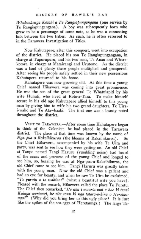
Page 53
KAHUTAPERE
Block got its name through this incident. Anyone visiting this country will find it very rough and mountainous. The visit came to an end, and Hikawera accompanied the old Chief part of the way home. Crossing the river Waipunga, the day being very hot, they sat down for a spell. Hikawera had been wearing a closely fitting hat made of birds’ feathers. Feeling warm, he took it off. The old Chief instantly exclaimed, “What a beautiful bald head you have!” Hikawera did not take offence; he at once named the place “Pakira a Hikawera” (bald head of Hikawera). They came at last to the parting of the ways. Before separating, Tangi Haruru noticed the magnificent pines growing all round him, and remarked what beautiful trees they were. “Yes,” said Hikawera, “they are my pare and my piki.” The place got the name of “The Plumes of Hikawera.” After a short stay at Te Purotu, Hikawera and his companions returned to Heretaunga, taking a few friends back with them, and from here they went straight on to his father, Te Whatuiapiti, at Te Roto-a-Tara.
AT ROTO-A-TARA. – His father saw him and his party coming in the distance and immediately made preparations to welcome his guests. He sent his man Te Tomo out to get some eels. This man obtained them and had them cooked but, instead of taking them to his Chief, ate them himself. When the Chief heard of this he was very angry. Calling the man to him he clubbed and killed him, and had him cooked and served up to his visitors.
Later, when the party returned home to Te Purotu, Hikawera went with them, taking with him some of Te Tomo’s bones for bird-spears. They camped at the Mohaka river, where the bones were scraped and cleaned. This incident gave to the place the name of Waitara (the water of spears). From Te Puroto, Hikawera went further on to a great bird-spearing place near the site of the present Tarawera Hotel. Here he had a successful bird-spearing season. Before leaving he built a hut and placed the tara, or spears, in it for next season.
Returning on a similar expedition next season he found that the hut had been burned down. After that the district
Page 54
HISTORY OF HAWKE’S BAY
got its name of “Tarawera,” the burnt spears.
Kawhea, son of Kurapoto, had a similar experience at Runanga. While there his hut was burnt, and in escaping he snatched from the flames his burning kit containing his bone spears. When he shook his kit outside he found that some of the spears had been burnt, and some say that Tarawera got its name through that incident.
After this the people at Tarawera seemed to have prospered, and lived at peace for some four or five generations, when the peace was disturbed by a family quarrel. Some time in the eighteenth century there lived two young friends, Pakapaka and Werewere. They both married at the same time and they made a vow that if one had a son and the other a daughter they would marry when they grew up. As things turned out, there was born to Pakapaka a son, whom they called Aria, and Werewere had a daughter, who was named Te Uira. These two children, by the vow, became betrothed while they were babies and they grew up together. Now it happened that Werewere wished to go to Taupo to see his friends, so he took the maiden Te Uira with him. While at Taupo, Te Uira met Tunui, and although she was affianced to Aria, she fell in love with Tunui and became his wife. He was a member of the Rangi-ita tribe. Now, when Aria and his people heard of this marriage they looked upon it as a great insult and a cause for anger. Aria set about and collected a war-party and went to Taupo to seek vengeance. They had some success, but did not attack the Rangi-ita, who had been responsible for the insult, but killed a Chief called Kikitara. Avoiding a strong pa in its path, the party returned by way of Hatepe, where one section of the raiders killed a Chief called Taupo, who was unknown to them, but who was one of their own relatives. His daughter Kahu escaped, and eventually was the means of bringing the news of the raid to Te Heuheu. Meanwhile, Aria and his party returned to their pas at Tarawera. Te Heuheu, hearing of the raid and of the death of some of his relatives, sent messengers out and assembled a strong war-party and set out for the pas of the raiders at Tarawera. Then followed a series of fights in which Te Heuheu was more or less successful, and which
Page 55
KAHUTAPERE
culminated in a large fight at Te Kupenga. This was a strong pa in the middle of Tarawera. In this fight the Chief Wharetoetoe was killed. After the fall of Te Kupenga the head of Wharetoetoe was cut off and hung up at the entrance of the track going to Taupo. This track has been known even since as “Te Whakairinga o te Upoko o Wharetoetoe” (the hanging of the head of Wharetoetoe). The Ngati-Kahungunu did not seek to avenge this raid as it was looked upon as a family affair.
Te Heuheu, after the fall of Te Kupenga and the killing of Te Wharetoetoe, asked his followers to cease the eating of human flesh. Since they were becoming related to people all around they could not be certain that they were not eating their own relatives. The killing and eating of people now became gradually less and less.
HAUHAUISM. – Many years later, new cults appeared, one of which was Hauhauism. This was a new type of religion amongst the Maoris. The karakia, or prayers, ended with the words, hau hau, a sort of “amen.” It started at the time of the Rev. Carl Volkner’s death at Opotiki. The most outstanding leader was Te Kooti, who was looked upon as a god, and who left a track of blood and fire in his wake. The Hauhau people objected very much to the sales of their land to the white people, and wanted their own country for the Maori. The new religion soon spread, and it was introduced to the Tarawera district by the tohunga, Panapa. A Hauhau camp was set up at Tupurupuru and at Waiparati, and converts began to pour in. They were soon joined by Nikora and other leaders at Tarawera, and they became a strong organization. The new religion spread to other people in the district. They had three atuas, or gods, called Ruru, Riki, and Merekihereke, and also had three flags. The leaders of the new cult expected all the people in the district would take up the new religion and thus defeat the atuas of the missionaries. Tarawera thus was a hotbed, seething with rebellion. The Crown, become apprehensive, built redoubts at Te Haroto and Tarawera. In the meantime the country was much disturbed by other Hauhaus under Te Kooti. Guns were, by this time, an important factor in war. The Maori loyalists of Tarawera, apprehensive
Page 56
HISTORY OF HAWKE’S BAY
of trouble, left the district and went to Heretaunga for safety. Two of the loyal Chiefs, Tareha and Karauria, were anxious to remove their people from those who were affected by the outbreak of the Hauhauism on the East Coast, at Gisborne, Waerengaahika and Wairoa, as well as at Tarawera.
The town of Napier was well protected. There were several powerful Chiefs residing round about, including Tareha, Karauria, Captain Tomoana, Paora Kaiwhata, and others. Whilst these warriors were in the district Te Kooti would not dare to make a raid.
The fanatics of Tarawera, excited beyond control, made their way down to Napier. The Chief Karauria went up and met them at Titiokura. They would not declare whether they were for war or for peace and Karauria advised them to go back. He also spoke to several of the Hauhaus who had reached Petane. Shortly after he paid them another visit and had several of them sworn in. The fanatics, however, still persisted in making their journey and came with a large party under their leaders, Panapa, Keepa and Nikora and camped at Omarunui. It was uncertain whether these people came in peace or war, as they still would not declare themselves. Meanwhile the white people around here were becoming alarmed about these unwanted neighbours. The local Chiefs went out to Omarunui to see the Hauhaus, hoping to reason with them and get them to go back. They got their answer. It was by means of a chant. In a song chanted by a Hauhau, Kipa, they were told it was impossible for them to retreat. In the Hauhau party were several people from Taupo, and they had not forgotten the great defeat inflicted upon them a few years before at the Lake of Tara by Pareihe and Te Wera. That defeat had not been avenged and that, no doubt, was one of the incentives.
The local Chiefs returned to the big pa at Pawhakairo (the carved pa), near Waiohiki. They were soon joined by the soldiers, militia, and native loyalists, and they advanced to meet the fanatical raiders. The fight lasted one hour, forty minutes, and ended in the complete defeat of the Hauhaus. The prisoners were deported to the Chatham Islands, from when they later escaped.
Page 57
TU AHURIRI
It seems strange that these people, one of whose object was to prevent sales of Maori land to the pakeha, were themselves the very means of throwing large tracts of native lands into the hands of the Government through confiscation for acts of rebellion.
When these people under Nikora and others were making a raid on Napier by way of Omarunui, a small party, under the Chief Te Rangihiroa came down from Te Haroto to join and aid their friends. Their intention was to make a concerted raid on Onepoto. They were intercepted by a party of soldiers and loyal natives at Herepoho, now Eskdale, and in the skirmish that followed Te Rangihiroa was killed and his followers routed.
Thus ended the conquest started in the first place by Kahutapere. We will now go back to other events starting contemporaneously with Kahutapere’s campaign.
CHAPTER IV.
TU AHURIRI.
Tu Ahuriri was the son of Tu Maro, a Chief of the Ngai-Tara tribe, who lived at Hataitai, Poneke, towards the end of the Seventeenth Century, and of Rakai-te-Kura, a Chieftainess of the Ngai-Tahu tribe. He formed a connecting link between the two tribes. Deserted by his father from birth he lived with Te Ao Hikuraki and his mother until he was a young man. At the age of twenty-five he set out for himself. Accompanied by his two wives, Hine Kaitaki and Tuara Whati, he paddled up the East Coast and landed at Mahia, where he settled down and eventually became the head of a very big following. A time came when he began to be troubled about his parentage and demanded from his mother the whereabouts of his father, Tu Maro. In a large canoe with seventy of his men he went south. From now on followed a series of interesting events in the life of Tu Ahuriri, which are not concerned with this district. He eventually returned to Mahia, bringing back with him his grandfather, Kahukura.
Page 58
HISTORY OF HAWKE’S BAY
Tu Ahuriri’s life was not always a rosy one. He had, in some way, offended his cousin, Hika Oraroa, who was a very powerful man and a veteran warrior of his own tribe. Hika made up a war-party by collecting all his near relatives and dependants and proceeded to attack Tu Ahuriri in his pa. He reached the pa in the early dawn.
While Hika was leading on his men a young man called Turuki rushed past him to lead on the attack. He was stopped by Hika with the scathing words, “Why should a nameless warrior try to snatch the credit of a victory he has done nothing to win?” The young man, very much annoyed, went to the rear and complained to Tutekawa, the head of his family and one of the leaders. This leader there and then, unknown to Hika, withdrew his following and quietly went round on the other side of the pa and thus was ahead of Hika in the attack.
Tu Ahuriri, not expecting this raid, was asleep in the pa at the time of the attack, but he succeeded in making his escape, leaving his two wives, Hine Kaitaki and Tuara Whati, to their fate.
Those two women were rangatiras and of very distinguished lineage. The raider, Tutekawa, was a relative of their husband, and according to the rules of war, their lives ought to have been safe in his hands, but Tutekawa was a cruel and vicious man, and, finding that Tu Ahuriri had escaped him, he killed the two women.
Later, when the war-party was leaving, Tu Ahuriri came out of hiding in the bush and cried out to Tutekawa to leave him his belt, waist-cloths and weapons, which were eventually thrown ashore to him. Tu picked up his property and then threatened his cousin with the vengeance of his atuas for the injury he had done him. He retired to the bush, recited his karakias and incantations and invoked the aid of his atua, and as the result thereof there arose a very great storm known as “Te Hau A Rongomaiwahine” (the wind of Rongomaiwahine). During the storm the fleet of Tutekawa was separated, many of the canoes were upset and the crews drowned. Tutekawa, with much difficulty, managed to survive the storm and escaped to the South Island, and there he decided to stay and escape the vengeance of Tu Ahuriri.
Page 59
TU AHURIRI
There is no record of any further attack on Tu. He rebuilt his pa and prospered. The time came when he desired to make a large meeting-house worthy of possession. The meeting house is the main feature of the Maori pa and the best craftsmanship and carvings are put into it. Tu set to work with his craftsmen to build the meeting-house, but possessing only stone implements they made very slow progress. After a long time, when they had erected only one side of the house, it was suggested that they go south to Te Waipounamu to get greenstone wherewith to make axes, which would enable them to do quicker and neater work. This was eventually agreed upon.
Preparations were now made for the journey south, and a large party set out. On reaching Hawke’s Bay they landed and camped at what we now call the Port. Now it so happened that at the time this party came the entrance to the Inner Harbour near Petane, known as Keteketerau, was blocked. This was caused by the action of the contending elements, though some went so far as to say it was done by makutu. This resulted in Te Whanganui-o-Rotu becoming a large inland lake, and with the inflow of the rivers it soon became very full. This had the effect of interfering with the food supply, and it became impossible to collect shell-fish and other products of the Inner Harbour. Some of the kaingas were flooded also. Tu Ahuriri, seeing the trouble, immediately set his party to work with the ko, or wooden spades, and opened up a course at the Port end of the Harbour. The slight opening then made was soon enlarged by the swift outflow of the banked-up waters, and result was a good channel was soon formed, which has remained the permanent outlet. The large Inner Harbour and the district surrounding have since been known as Ahuriri.
After this event Tu Ahuriri and his party went south, and that was the last the people here know of him.
TARAIA SETTLES NEAR TAHUNAMOA. – When Taraia became settled in the district he built a pa at Te Wai-o-Hiki, opposite Otatara, which was called Tahunamoa. A feature of the pa was its large meeting-house, “Te Raro akiaki,” the like of which was never known before. The erection of these
Page 60
HISTORY OF HAWKE’S BAY
houses was often accompanied by a human sacrifice. In this case the intended sacrifice was Te Raupare, Taraia’s own daughter. The night the house pole was to be erected karakias and incantations were said over the child before putting her in the hole. Hinepare, the mother of the child, had arranged with Te Whakawhiurangi to hide Te Raupare and place a covered stone in her place. Taraia conducted the ceremony, and when the child was handed to Te Whakawhiurangi to place in the hole he deftly hid her under his clothes and, at the same time, pushed a stone into the hole instead. The post was placed in position, the hole filled up and the child was secretly returned to her mother. When Taraia went home that night and found the child he was much incensed, but could do nothing as the pole was erected.
And now followed a series of fights. These people were always quarrelling with other tribes or with their own kin.
When the child Te Raupare grew up she was kidnapped by Ari Ari, a member of Te Hika-a-Papauma Hapu, who took her to Pokairikiriki, in the forest, where Taraia could not find her, and she became his wife. When Te Raupare became enceinte, Ari Ari arranged to take her to Turanga. She desired to get some clothes before going so went to Tahunamoa, and at night stealthily entered her mother’s house. She was just taking out a bundle of skins and feathers when she trod on her mother’s leg and was caught. Taraia, when he found that she had been with Te Ari Ari was enraged. He called to Te Whakawhiurangi, to whom she had been betrothed, and told him of the insult, with the result that a fighting force proceeded to attack Ari Ari. The fight took place at Te Awa-hou-a-Te Pourewa pa. The pa fell and Ari Ari was beaten, but he managed to escape. He fled to Awakari and took refuge in the pa. thinking to deter the war-party, he placed the head of Wairakau, who had died some time previously, in the gateway of the pa, and then fled to another pa in the distance, called Tatakaka, from where he watched events. The war-party did not respect the head in the gateway, but threw it into the water. Seeing that his plan had failed, Ari Ari and his party left this pa also and fled to the head of the Ohiwa stream, whither he was followed by the war-party. Exchanging a few words with them across the stream, Ari Ari then
Page 61
TU AHURIRI
escaped to Kauhanga on the other side of the Tuki Tuki River. This pa belonged to his people, the children of Papauma of Te Hika-a-Papauma, and among them he raised a war-party and returned to attack the Tahunamoa pa. It was a bloodless victory, however, as there was no one in the pa. They then wrecked the place. They cast down Taraia’s stone idols and threw them into the pa, and destroyed the fine meeting-house that Taraia had built. Taraia, watching at a distance, called to them to spare the idols but to destroy the house, but they did not heed. The party then returned to Kauhanga.
Associated with Taraia were the Ngai-Tamawahine, so called from the fact that the first four children of their progenitor, Tama Raeroa, were all girls. They came from Turanga soon after Taraia arrived here. After the desecration of the idols they joined Te Hika-a-Ruarauhanga and formed a large avenging war-party. They held a great war-dance at Heretaunga, and boasted of their bravery and of what they intended to do. They proceeded by night by way of Korongata to attack the Totara pa, across the swamp at Paki Paki. A friend in the enemy camp had hastened to Totara and given the inmates timely warning of the approach of the war-party, and feverish preparations were made for its reception. On its way the war-party attacked and took three settlements before daylight. Proceeding to Totara they found the pa ready for their reception, with all the inmates on the alert. The war-party did not take the pa, so went on to Waikou-kou, which was attacked and taken. One of the men escaped to Kauhanga, where the Chief Takaha was staying. He was a man with red hair, by means of which he was later identified to his undoing.
TE ARAI-O-TURANGA. – When Te Ari Ari’s war-party of Te Hika-a-Papauma heard of Taraia’s war-party they advanced on Paki Paki. Their approach was noticed by one of Taraia’s men, who was studying his reflection in the water when suddenly he saw the reflection of others. Looking up, he saw the enemy approaching, and immediately warned his people. The Ngai-Tamawahine and Te Hika-a-Ruarauhunga did not wait for the enemy to arrive, but went out to meet them. It happened that there were a large number of Chiefs in both
Page 62
HISTORY OF HAWKE’S BAY
parties, and they called to one another arranging that the fight should be by front ranks of Chiefs.
When Taraia’s warriors were at Heretaunga dancing the war-dance and boasting of their valour, a young lad named Kuikai was listening to them. He had a keen desire to join in the fighting. Hearing that Taraia had left his cloak behind at Pakowhai, he offered to go back and get it for him. He went to Te Hika Pukanohi, where the old warrior Rakaihikuroa lived. He told the old man he had come for Taraia’s cloak, but his real object was to obtain a weapon in order to take part in the fighting. The old man advised him to stay at home, but, as the boy was determined to go, he was given a spear and then a maipi, as well as a lesson in the use of these weapons. The boy then asked about the Chief Takaha. Now Takaha was a warrior and a very brave man. He was grand-father of Te Whatuiapiti, and belonged to Te Hika-a-Papauma tribe. Rakaihikuroa was surprised at the youth choosing such an antagonist and warned him against fighting with his elderly relative since he was small and not sufficiently strong. The youth replied, “It is the smallest bird that reaches the top of the kahikatea tree first.” The boy was then told that he could not mistake his elder for he was red like a gurnet. Huikai rejoined his people at Korongata, and was with the Nga-Tamawahine when the two parties were facing one another.
The battle was fought on the ridge above Paki Paki, and was very fierce. The youth Kuikai climbed on a man’s shoulder and soon singled out Takaha by his red hair. He got down, engaged Takaha in single combat and succeeded in killing him. The battle ended in the defeat of Te Hika-a-Papauma. The leader, Te Ari Ari, and one hundred and forty other Chiefs were killed. The only Chief who escaped was Tama Ariki, who was left for dead on the battle-field. He was found to be alive when the victors, after the fight, went to dissect the bodies of the slain, for he moved when an incision was made in his skin. The people returned to Whaka-whiurangi, who was wounded in eight places. When he was told that all the Chiefs except Tama Ariki were killed, he wept over his dead relatives. He was carried to the place where Tama Ariki lay, and placed beside him, with the result that
Page 63
TU AHURIRI
his blood flowed on to Tama Ariki, who was thus made tapu. Although this made the people angry the Ngai-Tamawahine danced a great haka over Tama Ariki. The hearts of the slain were placed in a hollow in a stone on the ridge and cooked. This stone can be seen to this day and is called Te Ahi Manawa (the fire of hearts). This fight was in revenge for the desecration of Taraia’s stone idols, as well as for the Ari Ari insult.
Some three years afterwards, this defeat was avenged. Taraia, now old and infirm, lived at Te Kauhanga pa. While Te Whakawhiurangi was fishing at the mouth of the Ngaruroro the war-party came. The lids of the holes in which Taraia stored the heads of fish and other foods as offerings to his gods were removed, and clouds of flies went up in columns to the sky. Takaimoko, who had seen this, told Taraia of the act of sacrilege perpetrated by the war-party, saying that it had been done in revenge for Te Arai-o-Turanga.
Taraia, accompanied by his wife Hinepare, and his elder brother Ue Wherua, went to Tahunamoa pa. They were seen approaching by the war-party. Taraia and his brother were killed, but Hinepare was spared. A fight took place outside the Tahunamoa pa and all Taraia’s people were killed, except Te Whakawhiurangi, who escaped. The children of Taraia were then living at Kohukete pa. Hearing that Taraia had been killed, they came immediately to the Tahunamoa pa, but when they arrived, the war-party drove them right back to the Kohukete pa. This pa was taken with the loss of several lives. This fight was also in revenge for Te Arai-o-Turanga.
TE KAUHANGA. – Te Whakawhiurangi, who had escaped from the fight at Tahunamoa pa, determined to avenge the death of Taraia. As soon as he was able to do so he mustered an avenging party and proceeded to attack the enemy at Te Kauhanga pa. This pa was occupied by Te Hika-a-Papauma. In the fight that ensued the pa fell and many of the inmates were killed. Te Whatuiapiti, then a lad was in Te Kauhanga at the time. He managed to escape with a few of his elders, and fled to Wairarapa. Thus Taraia’s death was avenged.
Page 64
HISTORY OF HAWKE’S BAY
CHAPTER V.
TE WHATUIAPITI.
Takaha
Hikawera I
TE WHATUIAPITI (circa 1600 A.D.)
Te Kauhanga defeat was avenged some time afterwards. There was no fight, but the revenge consisted in killing a person now and then as opportunity offered. After escaping from the pa Te Whatuiapiti bethought himself of his uncle Tamapuhia in Wairarapa. After the conquest of the whole district by Taraia and Te Aomatarahi several of the Ngati-Kahungunu went into occupation at Waiarapa. It was not long before Te Whatuiapiti made a name of himself.
The Rangitane, who had been driven out of Wairarapa, were in occupation of the country on the other side of the Tararua and Ruahine Ranges. Te Whatuiapiti led a fighting force over the ranges, attacking and defeating them at Te Wharemauku, and gained two victories. After this he remained in Wairarapa until he had quite grown up and had become a warrior of some standing. He then decided to return to Heretaunga. Coming up by way of the coast he killed Te Rangirawaiwaho at Taurape, and later, Te Ikapuna at Mataikona. On reaching Akitio he killed Wharerauruhe. This man had married a member of the Rangitane, a tribe that had come from Turanga, and to which Hinepare, Taraia’s wife, belonged. They were descendants of Whata. She escaped to Heretaunga and told the Rangitane what had happened. The Rangitane then raised a war-party and went to attack Te Whatuiapiti and avenge the death of Wharerauruhe. Te Whatuiapiti was encamped at the mouth of the Wainui River. The Rangitane came down the bed of this stream and their marching made the waters muddy. The Wainui was a swift running stream, thus the muddy waters preceded them. Te Whatuiapiti, noticing the muddy waters and reading the signs, immediately collected his party and went to meet the enemy. In the fight that ensued the Rangitane were defeated.
Page 65
TE WHATUIAPITI
After this, Te Whatuiapiti went to Porangahau, where he stayed. He did not want the Ngati-Kahungunu to occupy this place. Some time later he went to Waipukurau, where he discovered that two of the Chiefs, Tupokonui and Tupaka, were about to divide the land, so he killed them. From here he went on to Heretaunga and on to Takutai-o-te-Rangi, opposite Otatara. Te Whatuiapiti was a fine big man with reddish hair, and with a head-band decorated with huia feathers (tipare huia) he looked an imposing figure leading his men on to the attack. The Ngati Kagungunu were laying in wait, but they were prevented from fighting by Huhuti, the daughter of their Chief Tangitaumaha, because she wanted to admire the approaching warrior. Te Whatuiapiti thus gained a bloodless victory. This was known as the Tiparehuia fight.
Te Whatuiapiti returned to Porangahau. The Ngati-Kahungunu made overtures for peace and sent emissaries to Porangahau, where peace was made. Their leader was a woman named Hine Te Aorangi. She invited Te Whatuiapiti and his people to return to Heretaunga and to occupy the places formerly owned by him. He accepted the invitation, and he and his people went to the Pohatu-nui-a-Toru pa at Ruahine. When the people of the district heard that he had come back they sent messengers to invite him to come to Tawhitinui to establish a permanent peace. Te Whatuiapiti himself did not go, but he sent forty women and two men as a peace-offering. The Ngati-Kahungunu, under their Chief Pokia, some of Rakaipaka, prepared a house for their reception. It was built by Pokia and the descendants of Taraia, called “Mata Kakahi.” Te Whatuiapiti’s elder, Te Aokamiti, came with these people, who were welcomed in to the house. As soon as the people entered into the house the doors were closed and they were massacred by Pokia and others. During the slaughter, a man on the roof, looking through a hole, saw what was occurring. His name was Tuterangi. The elder of Te Whatuiapiti, looking up, saw him and said, “If Te Whatuiapiti hears of this tell him not to avenge this massacre the same way.”
After killing these people Pokia mustered his Ngati-Kahungunu forces and marched to Tapuaerau to kill Te Whatuiapiti. They heard that he was sore from his recent wounds.
Page 66
HISTORY OF HAWKE’S BAY
Reaching Tapuaerau they found that Te Whatuiapiti was there, so they at once attacked the place. Te Whatuiapiti escaped, but his uncle Tamapuhia, who had accompanied him from Wairarapa, was killed. As Te Whatuiapiti was escaping Tuterangi called out to him to stop and he delivered to him the message given by Te Aokamiti when the women were being slaughtered in the closed house.
Te Whatuiapiti and his followers retreated to their Pohatu-nui-a-Toru pa. This pa was built on a rocky pinnacle and was very strong and inaccessible. Pokia and his warriors attached the pa, but could not take it, and ultimately returned to their home.
Te Whatuiapiti, as soon as he recovered, determined to seek reprisals for the treachery at Tawhitinui when Te Aokamiti and the women were massacred, and for the attack on him at Pohatu-nui-a-Toru. Gathering together his forces he marched to Takutai-o-te-Rangi and there attacked the people of Taraia and the Ngati-Kahungunu. He defeated them in two battles, one at Te Roropipi and the other at Te Aroaro Tahurihuri. He thus got his revenge. These defeats were never avenged.
After this peace was made, Pokia, as a peace offering, gave a woman, Hineipehinga, to Te Whatuiapiti in marriage, notwithstanding the fact that she was already affianced to another man, Tukutuku. They went to Wairoa, where her parents resided, and were married there. When they returned they lived on the island in Roto-a-Tara.
UPOKO POITO. – An event happened about this time which is worthy of note. Whilst Te Whatuiapiti was at or near Ahuriri a party of excursionists from Mahia came down the coast in their canoe. One day they went out into the bay opposite the present town of Napier on a fishing trip. Luck was against them for, after fishing all day, they caught nothing but a few red gurnet. One of the party, joking over their ill-luck, remarked that the gurnet were just like the red hair on Te Whatuiapiti’s head. Now, that was a very grave insult indeed, and to a Maori could only be wiped out by blood. The fishing-party returned and then turned their canoe homewards to Mahia. By some means or other Te Whatuiapiti
Page 67
TE WHATUIAPITI
heard of the remark jokingly made by the visitor, and was very angry. How dare anyone compare the gurnet to the hair on his head! He quickly collected his warriors and picked out of them those that were the most expert with the paddle. Placing his tohunga aboard and manning his canoe he set out in hot pursuit of the insulting canoe. The excursionists had almost reached home and were hauling up their canoe when they saw the war-canoe approaching in the far distance. Being apprehensive and knowing what to expect, the excursionists called upon their people, and in a short time three large canoes were manner and launched and set out to meet the approaching canoe.
Te Whatuiapiti, seeing the change in the situation, thought discretion the better part of valour and ordered his canoe to be turned round, and to proceed homewards. The Mahia party, not to be baulked, now became the pursuer. Some of the Wairoa people saw what was happening in the distance and thought they, too, would join in the chase, so two large canoes were quickly manned and joined the pursuers. Now commenced a grilling chase, and race. Te Whatuiapiti had not chosen his paddlers for nothing. Though exhausted by the long trip to Mahia and the race homewards they kept their distance until they reached the bay in front of the present town of Napier, when the enemy gradually drew near. Te Whatuiapiti then called upon his tohunga. The tohunga, standing up in the canoe, then bowed to the sacred mountain of Kahuranaki, repeated his karakias and incantations, and then bowed defiance to the approaching party. It was noticed that a small, dark cloud suddenly appeared over Kahuranaki and a gale sprung up from off the sea, which soon churned up the water. Whatuiapiti’s canoe, with the five canoes in hot pursuit, forged its way through the great waves which now came tumbling in towards the mouth of the river, and by the clever manoeuvring of the steersman the canoe shot shore-wards into placid waters. Not so, however, with the chasers. The leading canoe, when about to turn, was caught on the curl of a wave, was overthrown and the occupants were hurled into the sea. One by one the other canoes were caught in the same way, and the occupants all cast into the sea. It is said that only one man escaped from the drowning and he leaped
Page 68
HISTORY OF HAWKE’S BAY
from one canoe to another when it was about to turn over, and eventually reached the shore. He was not killed on account of his prowess.
Presently the drowned were carried by the current along the shore from Waitangi to the Bluff near the breakwater. Black heads could be seen bobbing up and down like poito or floats in the water. The foreshore from Waitangi to the Bluff has ever since been known as Upoko Poito (the heads bobbing up and down).
Thus was the insult to the red hair of Te Wahtuiapiti suitably avenged.
Kotore and his wife, the parents of Hineipehinga, wondering how she was faring, went to visit her at Roto-a-Tara. When they arrived Te Whatuiapiti was busily engaged repairing the roof of his whare and did not pay them much attention. They made much of their daughter, crying over her. Te Whatuiapiti, seeing no reason for this, called out asking the necessity of so great an ado. The tangi ceased, but the parents felt hurt at this remark, and did not forget it. Before returning to Wairoa the parents extracted a promise from the couple that they would come to Wairoa on a certain date.
When the time came for the visit of Te Whatuiapiti and his wife, the people of Wairoa made extensive preparations. A new house was erected for them on a small rise. Tukutuku, the discarded lover of Hineipehinga, was at the pa. Being an ugly man, he was handed over to the tattooer of the kainga for a few embellishments. He was tattooed all over his chest and abdomen, then turned over and tattooed on his back. Special attention was given to the rape on his buttocks. The visitors duly arrived and were installed in the new house. They were entertained with hakas, war-dances, and in numerous other ways known to the Maori until it came to the star performance. The potaka, or top, played an important part in the games of the Maori and also in his ceremonies. There were different kinds of tops for different uses. In this case Tukutuku was to lash a big top up the gentle slope past the visitors and down again. Presently he started. Slowly lashing his big top up the slope he brought all his limbs into play, and the visitors were much taken with the adornments
Page 69
TE WHATUIAPITI
on his body. When Hineipehinga saw the embellishments on the back of her lover, the rape on his buttocks completed her conquest. During the night Te Whatuiapiti lost his wife. Enquiring next morning where she was, he was told she had gone with Tukutuku to a certain village. Thither Te Whatuiapiti went to get her, only to be told that she had gone elsewhere. This was repeated until Te Whatuiapiti realised he had been tricked. Soon he made his way homewards without his wife. This, however, did not seem to dampen his spirits. Reaching Tangoio, he was seen climbing up the hill blowing on his putorino as he went. The people in the pa called to him wanting to know who he was, and where he was going. He replied, “Well, what of it, have you got a wife for me that you ask?” The people saw that he must be a someone of consequence, for no one but a rangatira dare give an answer like that. Soon they found that he was the great Whatuiapiti. He was invited into the pa, where he was accommodated. Some of his descendants are there to this day.
When he left Tangoio, he bethought himself of the bloodless fight at Tiparehuia and of the Chief’s daughter, Huhuti, who had so much admired him, so thither he wended his way. His visit was not appreciated and his attentions to Huihuti were not approved. The girl was well guarded and carefully watched. Te Whatuiapiti returned to his island home at Roto-a-Tara. Shortly afterwards his mother, Hinetemoa, when going out of her hut, saw a naked girl in the water. It was Huhuti. She had escaped from her people at Oneroa, and made her way to Roto-a-Tara. Divesting herself of her garments, she plunged into the lake and swam out to the island. Hinetemoa began to scold her, and likened her to an eel changing its skin, a tuna hore, and also to a naked image, a teko. Te Whatuiapiti, hearing voices, went outside and soon grasped the position. He sent his mother inside and took Huhuti. She became his permanent wife. They became the parents of famous children and an illustrious line of Chiefs. Two of the daughters were named Hinehore and Hineteko, after the lake incident.
Their first child was born at a place called Mahia, near Te Hauke. Te Whatuiapiti sent a messenger to Oneroa to the Chief Te Rangihaumaha notifying him of the birth of his
Page 70
HISTORY OF HAWKE’S BAY
grandchild, and asking him to come and name it. Te Rangitaumaha at once sent word to his half-brother, Karaka, who was living at Te Ipu-o-Taria at the mouth of the Ngaruroro. He was an expert at such ceremonies. Great preparations were made for the ceremony, which was attended by certain tribes, who collected food to bring with them. The contribution of Te Rangitaumaha and his people was one hundred and forty baskets of fresh water kakahi (shell-fish) from the Oingo lake. When the people arrived they were served with large quantities of papahuahua, or preserved birds, supplied by Te Whatuiapiti. When Huhuti saw what a poor gift her father had brought she felt ashamed and she wept.
Te Rangitaumaha said, “Woman, I have no better for you, all I can give you is your Elders, your brothers and my land”.
The child was named Te Wawahanga-o-te-Rangi. After this, Te Huhiti lived at Raukawa together with the people that formed her gift.
They had four children, of whom Hikawera II was perhaps the most noted. When he reached manhood he lived at Oneroa and took care of all the lands in the gift of his grandfather, Te Rangitaumaha, to his mother. He was a great warrior and had several pas scattered over the land from Tangoio to the Kidnappers. His mana increased after he allied himself to the old Chief Kahutapere by marring his two grand-daughters, Te Uira-i-waho and Te Atawhaaki.
Hikawera and Te Uira-i-waho had eight children. When his second child, Te Whakapakaru, grew up she fell in love with a young Chief, Ruruarau, the son of Hikateko. This did not meet with the approval of Hikateko, so with a view to quashing the affair, Hikateko took his son away to Mataotao, near Moteo. This, however, only aggravated matters. A Maori maid in love is seldom thwarted, and the object of her affection has a poor chance of escape. Te Whakapakaru resorted to an old trick, even in the present day: she went off her food. Hikawera now took a hand in affairs. Seeing his daughter pining away day by day, he became enraged with Hikateko for removing his son and threatened to kill him. He took his daughter and followed Hikateko up the Tutaekuri and there married her to Ruruarau. The great Chief Hikawera could not be refused.
Page 71
TE WHATUIAPITI
The result of this marriage was three sons, Tuku, Te Umutaowhare, Te Wheao, and two daughters, Taura and Kaitoi. They lived at various places in the district, but principally at Tawhitinui. Tuku developed into an important personage, but he did not live long. He died a natural death, and Te Wheao (who was his half-brother) was suspected of having bewitched him because he had been turned away from home. Te Wheao was an expert fisherman and he was turned away because he appropriated all the eels. When he was ordered away, he went to live on Tapu-te-Ranga, a conical island in the Inner Harbour, called the Watchman. He, with his nephew Te Putanga-o-te-Rangi, was later killed by the Ngati-Kahungunu at the Paruparu fight.
When Tuku died, a large tangi was held at Tawhitinui. On his death-bed, he said to his daughter Hinahina Ariki, “If the red-haired one cries over me, you and my lands are to go to him.” This referred to Te Rangikoianake. “If the black-haired one cries over me, you and my lands go to him.” This referred to Te Rangikamangungu. By these words Hinahina knew that he meant that those who had bewitched him should be killed.
One of those who mourned for Tuku was the black-haired one, Te Rangikamangungu. It was then that he heard of the dying words of Tuku. He, and a companion Tutura, went to Te Wheao pa, near Te Hauke, and told Te Rangikoianake of Tuku’s dying words. He replied, “Go and kill them.” Mustering a war-party, Te Rangikamangungu attacked the Papoto pa and took it, killing all the people at one end of it, but saving the people at the other end, as arranged with Te Rangikoianake. Some of the bodies of the slain were taken to Tutura and Te Rangikamangungu to Hinahina Ariki, who welcomed them and pointed out to them the gift of her father Tuku.
Te Rangikamangungu later went to live at Te Kairae, a fortified pa on a ridge. It was not long before trouble arose, caused through Te Rangikamangunu entering the kumara plantation of Tamaihotua and eating his kumaras. This affront resulted in a war-party under Kawakawa going forth to seek utu for the eating of the kumaras.
Hawea a Chief who was then living at Upokohina (grey head), heard of this so immediately set out for Te Kairae.
Page 72
HISTORY OF HAWKE’S BAY
As soon as he reached the pa the war-party under Kawakawa came in sight, so Hawea advanced to attack them. Kawakawa and his warriors then feigned a retreat, and while Hawea was in hot pursuit, they suddenly turned round and attacked him, and he was wounded. Kawakawa and his party then retired. The people in Te Kairae were not satisfied with the result, so they followed and overtook Kawakawa at Paherumanihi, and in the resulting fight Hawea’s people were again defeated.
The people in this district not fled. The Ngati-Hinepare, who had previously attacked Te Rangikamangungu, went to Puketitiri. Hawea went to his pa at Te Awanga, taking with him the Ngati-Hineiao, and Te Rangikamangungu fell back on Matapane, a pa where Napier now is.
After Hawea recovered from his wounds, he returned from Te Awanga and determined to seek reprisals. He gathered a force and attacked a peninsula pa in the Inner Harbour named Otaia. This pa belonged to Te Whakapakaru’s descendants. The pa fell, and the Chief Kiatoro was killed. Those who belonged to Hikawera and Te Whakapakaru were saved, but all the strangers were killed. Hawea then returned to Te Awanga. He then decided to make an attack on the Ngati-Hinepare and the Ngati-Mahu, who had fled to Puketitiri for refuge. Mustering his forces he marched thither, being joined by the Ngati-Rangikoianake and the Ngati-Whatuiapiti and others. This party attacked the refugees at Puketitiri and defeated them. Several Chiefs and six hundred of the refugees were killed. After this peace was declared.
Soon after Hawea’s return a quarrel arose between two sections of his people. It commenced with a game amongst the children, and as it progressed the elders joined in. Presently they divided, the Ngati-Hineiao on one side and the Ngati-Hawea on the other. During the game a man named Rarotawhana of the Ngati-Hineiao rushed forward and struck a man of the other side, killing him with one blow; the result was a free fight. Eventually the Ngati-Hineiao severed themselves from Hawea and joined another Chief called Te Uamairangi, who was living at Ruahine.
Page 73
TE WHEAO PA
CHAPTER VI.
TE WHEAO PA.
This pa was situated in the hills, just back of Te Hauke. In its day it was a very notable pa, and was known as “Te pa o nga Ariki” (the pa of Chiefs). In the time of Te Whatuiapiti the saying was “Ko wheao te pa, ko Te Wahuiapiti te tangata” (Wheao is the pa and Te Whatuiapiti is the man). In the constant internecine fights in the district and in the raids on outside tribes, the Chiefs leading on their warriors were often killed, and it was then that the party losing their Chief would make their way to the Wheao pa and ask that one of their Chiefs being given to them to be their leader and rangatira. In this way the pa had connections with all the tribes round about, and thus became immune from attack, as the rangatira would not attack his own pa. On the other hand, when a victory was won it was a common thing for the victors to send a present of some of the spoils of war to Te Wheao.
FEUD OF THE TWO RANGIS. – At one time there lived in the pa two Chiefs, Te Rangikawhiua, a grandson of Te Whatuiapiti, who was paramount Chief, and Te Rangihirawera, his cousin a minor Chief. These two did not agree very well, and the time came when Te Wheao pa was too small to hold the two of them. Te Rangihirawera, the disturbing element, left with a small following. He built for himself a small pa at the north-eastern end of the Poukawa lake. Some time later he sent a message to Te Wheao, asking Rangikawhiua to come and divide up the lake between them so that each could have his own fishing-grounds. Te Rangikawhiua felt insulted at the idea of a minor Chief coming to him, the owner of the lake, and demanding that it should be divided, so he sent the messenger back with a stout refusal to entertain the idea. One day, Te Rangihirawera cut out of the forest a long totara pole and took it to the lake. He knew where the best fishing-gounds were, so he proceeded with his pole and drove it in at a favourable spot – dividing off the best fishing-grounds for himself and leaving the other portion with the tuna kawa, or lean eels, for Te Rangikawhiua. From
Page 74
HISTORY OF HAWKE’S BAY
this incident the lake got its name of Pou Kawa (lean pole). As was to be expected, Te Rangikawhiua took no notice of this pole and took eels wherever he wanted. This incensed his cousin. Early one morning, Te Rangikawhiua looked out from his pa on the hill and saw a file of warriors rounding a small hill and entering the raupo. He knew it was his cousin coming to attack him, and instead of going the long way round the lake he was taking a short cut through the swamp. Quickly getting together a fighting-party, he made his way down to the lake and led his party into the raupo at a place where his cousin and party were likely to emerge. They had not long to wait. The oncoming enemy, not expecting any opposition, were struggling through the swamp and were suddenly set upon by Rangikawhiua and his party. It ended in the defeat of Te Rangihirawea and the routing of his followers. Te Rangihirawea escaped and fled to Patangata.
Here he established himself and, in course of time, gathered together a certain following. It was not long before he became very troublesome and aggressive, so Te Rangikawhiua gathered a war-party and attacked him. In this fight Te Rangihirawea was again defeated, but managed to make his escape and fled to Porangahau with a small party of survivors.
He again established himself and, in due course, became the head of a fair following. Ever restless, he soon began to cause further trouble to his cousin; so much so that Te Rangikawhiua again assembled a war-party and, marching to Porangahau, attacked Te Rangihirawea. In the fight Te Rangihirawea was killed and his followers routed. This ended to feud of the two Rangis.
No further attempt was made on Te Wheao. The pa still continued to be the cradle of some of the important Chiefs of Heretaunga.
NGATI-UPOKOIRI. – There had by this time gradually come into existence a hapu called the Ngati-Upokoiri. They were the descendants of Te Wawahanga and Taraia II, two of the children of Te Whatuiapiti by his wife Huhuti. This, coming as it did from a fighting strain, was a very strong, virile and bellicose hapu. They lived in and occupied a large stretch of undulating country in the upper reaches of the
Page 75
TE WHEAO PA
Ngaruroro and Tutaekuri rivers, known as Ruahine. They had many strongholds and pas, including Kihiao, Whakiuru, Ponapona, Te Pa-o-Tamahika, Whana Whana, Taumata-o-he, Matatoto, Matapiro, Tiki Whakairo, Maraekakaho, Kowhai, and Potaka.
This hapu produced many illustrious fighting Chiefs who carried out with exactitude the old Maori code of “an eye for an eye and a tooth for a tooth,” often extracting “two” eyes for “one”. This section became a very disturbing element among the tribes in the district. The useless decimation of the race brought about by the internecine and tribal fights, arising in many cases through what would now be looked upon more or less as jokes, was no wise abated during the time of the Ngati-Opokoiri. In fact, it continued with renewed vigour until the advent of pakeha civilization. The genealogical tree of the hapu overleaf shows some of the principal participants in the events that follow.
Te Upokoiri was the daughter of Rangikawhiua, and was born at Raukawa. She married Te Rangituouru, a grandson of Taraia II, and both went to live at Ruahine and became the founders of the hapu. It was to Te Uamairangi, a Chief of this hapu, that the Ngati-Hineiao came after leaving Hawea, and with him they joined.
Trouble arose between the descendants of Manawakawa and the descendants of his sister Te Upokoiri. It was caused through Ngamoa, a younger brother of Te Rehunga, coming from Waimarama to live with the Ngati-Upokoiri at Paritua, in the Raukawa district. He wanted timber to build a pa, so he asked for the Omana pa to be given to him. The Ngati-Upokoiri were living in this pa at Paritua and their Chief was Te Hurihuri. The people gave him the pa. It was dismantled and the timber floated down the Ngaruroro River, and thence taken over to Waimarama, where it was used in the erection of the Pukeake pa.
At Ngamoa’s request the Ngati-Upokoiri build him a house in that pa, but it was not completed as Ngamoa was not able to supply them with food. After the builders returned to their home Ngamoa died. It is said that the Ngati-Upokoiri had bewitched him. When bidding his people farewell he asked them to avenge his death. His children raised a warparty
Page 76
HISTORY OF HAWKE’S BAY
TE WHATUIAPITI=HUHUTI
Te Wawhanga
Te Rangikawhiua
Rahunga-i-te Rangi=Te Rehunga
Te Kaihou=Te Rangikoianake=Wakiterangi
Te Kikiri
Hawea
Karaha
Orihau
Wakiterangi
Te Pakau-o-te-rangi
Tahumata
Manawakawa
Te Rangikoianake
Mihiroa
Haerewa
TE UPOKOIRI=Te Rangituouru
Te Atakore
Whareau
Whakapau
Mumuhu-o-te Rangi
TE UAMAIRANGI
Tahoto Ariki=Te Matewaru
TE WANIKAU
Hori te Kahora
Rawenata te Weti
Hikatorohe
Umuwhakapono
Po
Taraia II
Te Honomokai
Te Rangituouru
Page 77
TE WHEAO PA
party to carry out the wishes of their dying father and proceeded to Opunua, a pa of the Ngati-Upokoiri on the Poporangi Range, near Ngatarawa. Ngamoa’s nephew, Tahumate, was the Chief of the war-party. They did not attack the pa, but they killed some stragglers who were living in a camp outside the pa. The Chief Tumihi was killed here. They made no further reprisals, but returned home to Waimarama by way of Te Hauke.
The Ngati-Upokoiri came out of the Opunua pa to the place where the slain were lying and uttered their incantations. They saw upon the ground the marks made by Tahumate where he had knelt and dried the head of Tumihi. They then bewitched Tahumate and he died.
As a reprisal for the death of Tahumate the descendants of Te Rehunga raised a war-party, and led by the Chiefs Pakaru and Te Weka they proceeded to Ongaru, where Tumihi was killed. Here a fight took place and Horonuku, a Chief of the Ngati-Upokoiri, was killed. The war-party then returned to Poukawa and Te Hauke and went into Te Weka’s pa, Parinui-o-Whiti. The Ngati-Upokoiri, mustering their forces, followed the war-party and attacked the pa. The pa fell, and all were killed except Te Weka, who managed to make his escape. He made his way to Pekapeka, and thence to Te Wheao pa, and thence to Puketatarariki and thence to Tokorangi, gathering a force as he went. They then marched to attack the Ngati-Upokoiri. When the party reached Paki Paki they found that the Ngati-Upokoiri had just left and had disappeared into the manuka. Te Weka, by climbing onto a man’s shoulder, located them, and off they went in pursuit and met the Ngati-Upokoiri as they emerged from the scrub. In the fight that ensued the Ngati-Upokoiri were routed with great loss. Te Weka’s party pursued them from Korongata to Opunua, killing them as they fled, and then returned home.
Te Uamairangi took refuge in the Opunua pa, but his brother, Te Amia Whenua, was killed. He grieved very much over his brother’s death, and decided to leave the district. Seeing his distress and hoping to prevent his departure, his friends planned to avenge his brother’s death. A war-party, under Te Taha of Tanenuiarangi and Hawea of Te Awanga,
Page 78
HISTORY OF HAWKE’S BAY
met at a place near Havelock and from there marched to Pare Waiehu, which was Te Weka’s pa at the Tuki Tuki. The pa was attacked, and it fell. All the inmates were killed, with the exception of Te Weka. Now that the death of Te Uamairangi’s brother was avenged he was pressed to stay, but he would not yield. He went to Te Awa-a-te-atu and lived with the Ngati-Pikiao. The avengers then returned to their homes.
Many years afterwards Te Uamairangi returned to his people. He joined his son, Tahoto Ariki, at the source of the Ngaruroro. This son used to quarrel with Tauwhitu, who was then living at the Taumata-o-he pa, but contrary to the usual custom, they fought with spears in single combat, sometimes one, sometimes the other being the victor. One day, when the inmates of the pa were away Te Uamairangi and his son entered and took possession. When the owners, the Ngati-Mate, with their Chief Rewha returned, they did not disturb the new occupants, but went to live at another pa called Toki Toki.
Some time after this, trouble again rose between the Ngati-Upokoiri and a branch of the Ngati-Kahungunu, known as the Ngati-Tuku-o-te Rangi hapu, whose Chiefs were Te Hauwaho, One One and Humenga. The fighting was caused through the illicit relations of Tahoto Ariki with Hineiwhaka-heke-a-ite Rangi, the wife of Hauwaho. One of Hauwaho’s friends named a Whata Kahawai (a kahawai storehouse) and a bundle of fern-root after Tahoto Ariki. Hearing of this insult Tahoto Ariki and his father Te Uamairangi came to Te Ngaio and killed Tawhito Whenua.
Te Uamairangi then went to Taupo to raise a war-party. He influenced a Chief named Pakaki Taiau of the Ngati-Kohera and also the Ngati-Rauwakawa, who, with their warriors, accompanied Te Uamairangi to Mangaroa, near Paki Paki, where they found Tatapora. They killed him and then returned.
After Tatapora was killed at Mangaroa, the war-party was advised by Te Uamairangi to return by was of the Ngaruroro as there would be puha (sow thistle, of which the Maori is very fond) by the way. He meant by this that on the way there would be numerous people, the Ngati-Mahu, the people
Page 79
TE WHEAO PA
he had previously given away. The war-party returned that way and killed some four hundred people of the Ngati-Mahu for puha.
Tatapora was a member of the Ngati-Kahungunu, and as a consequence of his death the Ngati-Kahungunu went in pursuit of the retreating party to exact reprisals, but failed to overtake them. They then fought with the Ngati-Upokoiri at Ruahine and defeated them, killing a large number. Peace was then made through the influence of Matewaru, the mother of Wanikau, on one side, and Te Rimu, a Wairoa Ngati-Kuhungunu, on the other side. The Ngati-Kahungunu then returned home.
Takotoroa wept a long time over the death of his younger brother, Tatapora. He went to Wairoa and there joined the war-like Ngati-Kahungunu. They formed a war party and came to Ahuriri under the leadership of their two Chiefs, Te Rimu and Tiakiwai. Here the Chieftainess, Te Herepou, persuaded her warriors to join the war-party because the death of her brother Toiratu at the hands of the Ngati-Upokoiri had not been avenged. They marched inland and camped on the banks of the Tutaekuri. Unknown to them a war-party from the Ngati-Upokoiri were on their way down the river. They caught the Ngati-Kahungunu asleep and attacked them, killing several. The slaughter was stopped by Hineitangihia, the daughter of the Chief Te Rimu, who commanded them to cease fighting. She then harangued her tribe, who rallied and defeated their assailants. A large number of the Ngati-Upokoiri were killed, but a few escaped. Among the Ngati-Kahungunu who were killed were the Chiefs Pakapaka, Tiki, and Tahiti, while the Ngati-Upokoiri lost Nohotatara. This fight was known as Te Kapo.
Returning to Wairoa the war-party called at Te Iho-o-Te Rei in the Inner Harbour, which was then occupied by some of the Ngati-Kahungunu and Ngati-Hinepare. They erected twenty posts at low tide and fixed on the top of them the heads of some of the people they had killed in their fights. Following the custom of giving a few names after an important event, Wi te Ota, a Chief of the Ngati-Upokoiri was called “Taipakihi” (low tide).
Page 80
HISTORY OF HAWKE’S BAY
A disturbance arose over the stealing of Rewha Rewha’s kumaras by some of Te Hauwaho’s slaves. Te Wanikau’s brother-in-law, Te Kauru-o-te Rangi, was then living at Ruahine. When coming down he camped for the night at a place just below Otatara. It happened that Rewha Rewha was not far behind. He was in hot pursuit of the thieves who had stolen his kumaras. When he came to the place where Kauru had camped, he said, “If I had caught my grandchild I would have taken him to my pa, Toki Toki, and hanged the water vessels of my child Tupurupuru to his ears.” Hearing of this curse Te Hauwaho raised a war-party at Wairoa, which included the Chiefs Tiakiwai Te Rimu, Te Whenua Riri, and others. The Ngati-Upokoiri were attacked at the Taumata-o-he pa, and in the fight Kii Pata, one of the Ngati-Upokoiri, was slain.
As a result of the words of a song composed by the wife and children of the slain Kii Pata, Te Hauwaho raised another force among the Ngati-Kahungunu of Wairoa and returned and again attacked the Taumata-o-he pa. This time they surrounded and set fire to it. They arranged for storming parties to enter the pa as soon as the fire made a gap in the palisades. The inmates of the pa comprised some of the Ngati-Upokoiri, with the Chiefs Te Uamairangi and Tareahi. Their position seemed to be helpless. As the palisading of the pa was burning, Te Rimu of the invaders saw Te Uamairangi moving away. When he saw their plight he said to Te Hauwaho, “We have gone far enough, don’t waste the people of Heretaunga.” Te Hauwaho was persuaded to enter the pa as soon as a gap was made by the fire and the fighting stopped. The inmates were not slaughtered.
There happened about this time one of those gruesome events that one swometimes hears of in connection with Maori life. There were great floods in those days, even as there are in the present day. Such an [a] one came and flooded the whole of the land in the Tutaekuri district. A party of the Ngati-Mahu were caught between two streams. As the waters arose they found no way of escape, and the party, comprising some fifty men, women and children, were all drowned. When the waters subsided all their bodies were found lying in a heap. The Chief
Page 81
TE WHEAO PA
Ruruarau had these bodies cut up, cooked and placed in kits, and he then sent the food as a present to the Ngati-Upokoiri. This was in return for a present of food which they had previously received and were unable to repay until now.
There lived at this time at Tutaekuri a member of the Ngati-Manawakawa hapu named Te Operoa. He was a relative of Tarewai and had come from Raukawa. When he came to Tutaekuri, Tarewai met his kinsman and camped with him. His fire was noticed by Te Paku-o-te-Rangi, a member of the Ngati-Mahu. Paku enquired whose fire it was and was told it belonged to the visitor. Paku then said it was not Tarewai but Tareahi. Tarewai looked upon this remark of Paku’s as a curse and attacked the Ngati-Mahu, who were living at the source of Tutaekuri, and killed several. He then went into occupation of their land and took those who were spared, and they lived under him. Tarewai belonged to the Ngati-Hinepare hapu, and they went with him to Tutaekuri. After this the two tribes lived and fought under the name of Ngati-Hinepare, and occupied the territory from Tutaekuri right down to Te Whanganui-o-Rotu (Inner Harbour), and continued so up to the time of the Chief Te Aria.
This much fought over district began now to receive attention from outsiders. It happened that a Chief from the Ngati-Kahungunu of Wairoa named Ruruku-o-te-Rangi of Mahia had come to live at Te Whanganui-o-Rotu and had taken a portion of it. While here his son died and it was claimed that he was killed by makutu. Accordingly a large party was collected to avenge his death. The party consisted of the Ngati-Porou and Rongowhakaato of Turanga, Ngato-Tahupo and Ngati-Tu of Nukutaurua, Mahia, the fighting Ngati-Kahungunu of Wairoa, the grandchildren of Kahu-o-te-Rangi of Mohaka, and warriors of the Ngati-Kahungunu who lived between Moeangiangi and Tangoio. This formidable war-party proceeded to attack the Tane-nui-a-Rangi pa. The pa was at that time occupied by the grandchildren of Hikawera, kinown as the Ngati-Tuku-o-te-Rangi. When this war-party arrived at Tane-nui-a-Rangi all the chiefs of the pa fled, with the exception of Takuku-o-te-Rangi, Te Rangikamangungu and Tatara-o-te-Rangi. These three were soon joined by Te
Page 82
HISTORY OF HAWKE’S BAY
Rangikoianake. Two of the chiefs of the district, Hawea and Te Pakaru, had joined the invaders thinking thereby to be saved. The pa was then attacked, but so well did the inmates fight that they repelled the invaders and defeated them. Those who escaped went back home. This was known as the Whaka-marino fight. The two Chiefs Hawea and Pakaru were spared.
The Ngati-Porou, when they reached Turanga, were chafing over this defeat. They collected a very large war-party to conquer the land and avenge the defeat. It was said that the war-party was so numerous that the ground could not be seen. Hearing of the approach of this great force Tutara sent a message to the tribes living inland at Motu Kumara and Koturoa. There were four hundred living in the Koturoa pa. Two hundred of them went to reinforce the hapus in Motu Kumara and two hundred went to the Tane-nui-a-Rangi pa. The invaders first went to Motu Kumara and attacked the pa. In the fight that ensued the pa fell and several people were killed, including some of their Chiefs.
The victorious war-party came by canoes down the river to attack the Tane-nui-a-Rangi pa. Reaching the pa they surrounded it and attacked it on all sides. By the time evening came they had made no impression. They then tried to burn it, but failed, they then made a tunnel and tried to enter by it, but failed. Each hapu then got ropes and fastened them to posts in the palisades, but failed to pull them over. Fighting became general right round the pa.
While Te Ruruku was on the other side of the stream he saw Hineioroia-Te-Rangi, who was the wife of Te Rangi-kamangungu’s son, standing on the battlements of the pa, with some stones and an axe in her hand. She was Te Ruruku’s daughter. Te Ruruku then called to his younger brother, Meke, “Have you no love for our daughter?” Meke and his followers then paddled in their canoes towards the pa till they reached the landing place known as Te Rae-o-Kore. Meke stood up in the middle of his canoe and called for an axe to be given him, giving his promise that he would withdraw the war-party on receipt of the axe. One of the inmates of the pa, Rangikaunuhia, brought an axe to Meke. This
Page 83
TE WHEAO PA
ended the fight. Meke turned his canoe round, and all the others followed him and returned home.
The various hapus now returned to their homes. Later there were one or two fights at Paratuna and Ngahape, in which the Ngati-Upokoiri were defeated.
The people of Heretaunga did not forget the invasion by the Ngati-Porou and other hapus, and the defeat at Motu Kumara, so sought vengeance. The Chiefs Te Hauwaho and Whakaato were the leaders. They went to Turanga. Their first objective was the Rango Whakaato people. They fought them at Panui and were victorious. Two pas were taken. On they went to the pa where Te Whiwhi was, but did not attack it in return for the withdrawal of the war-party at Tane-nui-a-Rangi. Returning home to Ahuriri and Te Awanga they heard that the children of Ratahou had been murdered by the Ngati-Porou. Ratahou belong to Te Mahia. Forth they went to avenge this murder. The leaders were Te Hau-waho, Te Humenga and Te Kauru. They collected a fighting force, one hundred and forty all told, manned their war-canoe called “Hota”, and set sail for Turanga. Here they were joined by the Rongo-Whakaato and the combined forces marched forth. It happened that at this time there was a very large meeting being held at Tokomaru, which was attended by the Ngati-Porou from Waiapu. They were assembled at Pawhare. The avenging party reached Tokomaru, went ashore and attacked the assembled Ngati-Porou, defeating them and killing thousands. This pa was on the banks of a deep stream. To escape the onslaught of the invaders some of those escaping jumped into the stream until it was choked with dead bodies, hence the reason of the great slaughter. At this fight several Chiefs of the Ngati-Porou were killed, including the great Chief Ngarangi te Maui. After obtaining satisfaction the war-party returned to Heretaunga.
The next trouble arose on account of a dream. A tohunga dreamed that a small kit of food was before him and that a hand with a rautao (tattoo) on it was on the food. The dream became known as Te Ringa rau tao a Whakato (Whakato’s tattooed hand). The news of this dream spread and it came to the ears of Whakato. He accepted it as a challenge. The tohunga belonged to Tahoto Ariki, son of Te Uamairangi.
Page 84
HISTORY OF HAWKE’S BAY
Whakato joined the Ngati-Hawea and came to attack Tahoto Ariki. Aware of their coming, Tahoto Ariki sent all his men into the bush to save bloodshed, but he remained in the pa with his young son, Te Wanikau. When the war-party arrived they found that he and his son were the only inmates of the pa, so for his bravery, they spared him and his son.
Further disturbances occurred at Mangatoetoe. Here there was a big fight. Kaiwaru, a son of Taraia and a member of the Ngati-Whatuiapiti hapu, had been weeping greatly for his kinsman, Te Rangitiri, who had been killed. He joined a war-party and went to attack the Ngati-Upokoiri. In the fight no one was killed, but as they returned, the Ngati-Upokoiri gave chase and killed Kaiwaru and several others. That fight was known as Tapuaerau.
His relatives, the grandchildren of Te Rangikoianaki, had a tangi over him and then proceeded to Ruahine, the district of the Ngti-Upokoiri, to seek utu for the death of Kaiwaru. They did not achieve much beyond catching a few stragglers outside the pas at Kihiao, Whakiuru, Ponopono and Te Pa-o-Tamahika. Upon their return the Ngati-Rangikoioanake formed a large war-party and proceeded on the march. At the same time a large band of the Ngati-Upokoiri was coming down to fight them. The Ngati-Rangikoianake marched that day as far as Whakapani-a-te-Koparetao, where they camped for the night. From here they spied the Ngati-Upokoiri in the far distance. The approaching band camped that night at Mangatoetoe. During the night the Ngati-Rangikoianake drew near to the enemy and in the morning made their charge. A fierce battle followed, resulting in the defeat of the Ngati-Rangikoianake. Several of their important Chiefs were killed, including Rewha Rewha, Kopiri, Whakahemo, Te Ringanohu, Tamanohorakau and Karahui. That battle was called Mangatoetoe.
The scene of the next fight was at Waipukurau, at a place called Pukekaihou. This pa was occupied previously by the Ngati-Kiriri hapu and other tribes. Te Ringanohu was a member of the Ngati-Kikiri hapu and when he was killed they left the pa. The people who fought at Mangatoetoe then went into occupation of the pa. The fight here was to avenge the defeat at Mangatoetoe. The people of this district were the Ngati-Whatuiapiti under the Chief Pareihe. It was against these
Page 85
RAIDS AND MAHIA MIGRATION
that the Ngati-Upokoiri with their allies of Mangatoetoe, the grandchildren of Rangitotohu, came to seek revenge. The battle was fought, and the Ngati-Upokoiri and their allies were defeated. Many of their Chiefs were killed, including Rewha and Te Motiti. Many of the slain were taken as a gift to Rangikoianake at Te Wheao pa.
After this, Te Kaihou, a daughter of Te Kikiri I and sister of Ringanohu, sent to Whatanui, asking him to come. He responded at once and came with a taua and three or four guns. He attacked the Okoraka pa at Tamaki (near Dannevirke), owned and occupied by the grandchildren of Rangi-rorohu. The pa fell and their principal Chiefs, Te Hoakakari and Hunanga Aorangi, were killed.
The Ngati-Upokoiri now kept to their pas at Kihiao and Whakiuru. They were afraid to come out because their foes, the Ngati-Whatuiapiti, were always on the alert waiting to waylay them. The Ngati-Upokoiri later mustered a war-party and proceeded to Pakowhai and attacked Te Ngaue pa, but without success. No one was killed, so they proceeded to Te Awanga and attacked the pa there, but failed to take it. The news of these attacks caused the Ngati-Whatuiapiti to assemble their forces and advance against their foe. When they reached Ngatarawa they found that the Ngati-Upokoiri had returned from Te Awanga and had just gone by, so they went in pursuit. The Ngati-Upokoiri saw their foes coming, so they took possession of a spur called Korongata. Soon the parties were engaged in conflict, and they fought all day until dusk. The warriors wished to continue the fight, but Kawa Kawa would not agree. Next morning the fight continued and raged all day, but no one was killed. The Ngati-Upokoiri escaped at night and fled to Patea. The Ngati-Whatuiapiti then returned to their pas.
CHAPTER VII.
RAIDS AND MIGRATION TO NUKUTURUA (MAHIA).
After this there commenced a series of raids from outsiders, the brunt of which was borne by the Ngati-Whatuiapiti at Roto-a-Tara and the surrounding hapus. The most important
Page 86
HISTORY OF HAWKE’S BAY
was that led by Tangi te Ruru. After the Mangatoetoe fight Te Hoeroa went to Wanganui to seek aid against the people of Heretaunga. On reaching Upper Wanganui he found the Chief Turoa busy building a pa in expectation of an attack from Tangi Te Ruru. At the suggestion of Te Hoeroa it was arranged that they make peace with Tangi te Ruru and get him to join forces with them against Heretaunga. Tangi te Ruru was partly of the Ngati-Porou and partly of the Ngati-Maru. After settling their quarrels he joined forces with them and led the expedition to Heretaunga. On their way they attacked the fugitives at Patea and defeated them. Among the killed was their Chief, Te Tuhi-o-te Rangi, and Pokaitara, a Chief of the Ngati-Whiti, belonging to Patea. Tangi te Ruru then came on to Heretaunga and attacked the Ngati-Whatuiapiti at Roto-a-Tara and captured the pa. The raiders then made their way to Waimarama and came to the Karamea pa. The inmates of this pa were a mixture of the tribes of Heretaunga. After enticing the inmates out of the pa by strategy Tangi te Ruru attacked and defeated them. Among the killed was Turereiao, the grandson of Hawea.
When Tangi te Turu captured Roto-a-Tara the Chief Te Nahu, who was in the pa at the time, managed to escape with a few companions and made his way to the bush at Ruahine. He was the son of Te Whakahemo, who was killed at the fight at Mangatoetoe. He was also the elder brother of Te Hapuku. He and his companions joined up with Te Whiu Whiu. It happened that Te Whiu Whiu was the only one of the Ngati-Upokoiri Chiefs who did not go to Patea. Te Nahu remained there until peace was eventually made in connection with the Mangatoetoe fight. To cement the peace Ihukino, the sister of Te Wanikau, was given to Te Nahu to be his wife. When the Ngati-Upokoiri, who were at Patea, heard that peace was made, they returned to Ruahine and Heretaunga and lived at the following pas: –
Matapiro
Tiki Whakairo
Aorangi
Taumata-o-he
Maraekakaho
Tangi te Ruru, after his successful raid, returned home,
Page 87
RAIDS AND MAHIA MIGRATION
taking with him a large number of prisoners captured by him at Roto-a-Tara, Waimarama, Te Awanga and other places.
After the return of the Ngati-Upokoiri they lived in peace with the Ngati-Whatuiapiti for a long time.
It is generally noted that when a tribe was not engaged in fighting or raiding the common enemy, it often had quarrels amongst its own members or hapus. These internecine quarrels were known as mate huanga. Such a state existed at Hauraki (the Thames). The people there at last became war weary and the fighting stale. To take their thoughts away from themselves the leaders made a diversion by creating trouble somewhere else. A raid on Heretaunga was suggested and agreed upon. A large taua was formed, comprised of the Ngati-Paoa and other tribes, including some of the Ngapuhi, who were then at Hauraki. The taua journeyed south by way of Taupo, and thence over the Ruahine Ranges, emerging from the bush on to the Ruahine plains. Here the local tribes made some resistance, but they were overcome. The usual cooking and feasting on the slain took place. Continuing on their raid the taua journeyed to the Hatuma lake, where it attacked and sacked the small Moana-i-Nokia pa. It then proceeded to the other side of the lake and raided the Kiorerau pa. The people here were fairly numerous and were at the time busy in their seasonal occupation of catching and preserving eels. The raiders sacked the pa, and the inhabitants were scattered. The war-party went on to Roto-a-Tara, where they found most of the warriors had gone on a fishing expedition to the coast at Waimarama. The raiders built some mokihis, or rafts, and crossed over to the island pa and assaulted it, killing the old people and children. They then left for home, going by way of Ahuriri and Petane, killing all they encountered.
Soon after this Te Nahu died. He was an important Chief, and was connected with the leading tribes of the district, so a big tangi was held. His body was handed over to the tohungas, and his brother-in-law, Te Wanikau, set about the preparation of food for the tangi. There is an old custom known as the rahui, by which an area of land and the food products thereof were on the death of a Chief, set apart temporarily, or made tapu. It was practically a warning to
Page 88
HISTORY OF HAWKE’S BAY
trespassers. Te Wanikau at once set up his rahui posts round Poukawa lake, and his rahui even extended to the Seventy-mile bush. This did not suit some of the people, whose supplies of food were cut off. Some of the descendants of Te Rangi-koianake went round the lake and pulled up the rahui posts and cursed them, saying they were the bones of Te Wanikau. This came to the ears of Te Wanikau, who, smarting under the insult, made his way to Taupo to invoke the aid of Te Heuheu and other Chiefs in avenging the insult. A large war-party was mustered. The warriors were from the tribes of the Ngati-Tuwharetoa, and the Ngati-Pehi and the Ngati Upokoiri. They came over the Ruahine Ranges by way of Raukawa (behind Te Aute College). Here they slaughtered a great many people, including the Chief Takotoroa. Calling at Te Waiharakeke, close by, they took numerous women and children prisoners. The war-party when teached the shores of Roto-a-Tara. The inmates of the pa on the island were representatives of many hapus, and included Ngati-Manawakawa, Ngati-Rangikoianake, Ngati-Ruatotara, Ngati-Te Kurapari and others.
As there were no canoes available the raiders could not get to the island. The main portion of the taua remained on the shores of the lake, while a small body went on a man-killing raid to Wairamara and Mangawharau. There they met members of the Ngati-Tamatere and Ngati-Kahungunu tribes and attacked them. The local people fought so well that the raiders were defeated. Amongst those of the enemy who were killed were Te Heuheu’s younger brother, Manuhiri, Te Wake, and Rangimarama, brother of Turoa. The survivors returned to the main body on the shores of the lake and reported their defeat.
Much concerned, the raiders decided forthwith to avenge it. Weeping for their dead they proceeded on the march. The inmates at Roto-a-Tara, haring them weeping as they went along, jeered at them, crying out, “How you and your grey-head cry” (referring to Te Heuheu). The raiders duly arrived at Aratipi, where their comrades had been defeated and found the local tribes still there. The attack was launched, the pa fell, and Te Heuheu’s party was victorious. Gathering up their forces the raiders then returned to Roto-a-Tara.
Page 89
RAIDS AND MAHIA MIGRATION
Though they remained there for some time they were unable to take the island pa, so returned home by way of the Ruahines, while their allies, the Ngati-Upokoiri, went to Patea.
The Patangata Chief, Pareihe, who was a seasoned warrior and a leader of some standing, determined to make reprisals. Immediately after the enemy had gone he gathered together a force of the Ngati-Whatuiapiti warriors and went in hot pursuit of the detached party of Ngati-Upokoiri, who were travelling to Patea. He caught and defeated them at Tara Whitiwhiti in the Tamaki district. The Ngati-Whatuiapiti went into occupation and remained at Patea.
The local people had not long to wait for the expected reprisals. The raiders had returned to their homes, but they could not forget the sting of the insult at the tangi by the lakeside. This, then, was the incentive for the formation by their leading Chief, Te Heuheu III, of a large avenging party.
A man of great mana, Te Heuheu called to his assistance a Hauraki tribe, the Ngati-Maru, also the Ngati-Raukawa, the Ngati-Maniapoto, and the Waikatos.
His ally, Tuwharetoa, also called to his aid the Ngati-Peehi, the Ngati-Rumakina, the Ngati-Rangiitia, Rauponga Whewhe and the Ngapuhi, who were at Hauraki.
Whatanui and Motu Motu, a Ngati-Upokoiri Chief, son of Te Kiipatu, also joined the taua. Some of the raiders were armed with guns.
This formidable party, under the leadership of Te Heuheu III, set out, came over the Ruahines and emerged at a place now called Gwavas, behind Te Aute College, killing people as they came. They eventually arrived on the shores of Roto-a-Tara.
Pareihe was now Chief of the Roto-a-Tara pa, and he was there with his people. For three months the raiders laid siege to the pa, but their efforts were in vain. Te Heuheu then directed his raiders to cut stakes from the nearby forest. With these he proceeded to build a puhara, a king of elevated platform, across the lake to the island. As this causeway advanced toward the island, Pareihe, too built a short puhara from the island to meet that of Te Heuheu. On the end he built a high tower. From this tower his warriors hurled rocks
Page 90
HISTORY OF HAWKE’S BAY
on to the builders of the approaching causeway. By this means Te Arawai, an important Chief of the raiders, was killed.
Unlike the land pas, which had entrenchments and under-ground huts, the swellings in this island pa were raupo whares above ground. The raiders, quick to note this, employed the usual tactics and began to throw fire-brands over the pa. The whares were soon aflame.
Hindered by the attack from the tower on the causeway, but undeterred in their charge, the raiders landed in force and stormed the pa. The besieged, notwithstanding their stubborn resistance, were impelled to retreat to the other end of the island. Here Pareihe rallied and exhorted his men. With a swift charge, he led them against the enemy. So well did they fight that the invaders were routed. They fled from the island, leaving their slain. Fifty Chiefs here met their end.
Pareihe did not follow up his victory by pursuing the enemy to the mainland. Quietly, in the night, he and his people abandoned the ruined pa and retreated to Porangahau.
The raiders took possession of the island pa and spent some days there eating the slain. When they were satiated they left for their homes at Taupo and elsewhere, going by way of Ahuriri and Petane. They took with them the prisoners they had captured.
The scene of this raid, the shores and bed of the lake, is now fertile pasture-land. The stakes used in the causeway can be seen there to this day.
After these events Te Whatanui came to Patea with a force, where he attacked and defeated the Ngati-Upokoiri. In this fight forty were killed, including Te Hoeroa and his parents. The Ngati-Upokoiri obtained their revenge by killing ten Chiefs of Te Whananui at the Otaparoto fight. Te Whatanui later returned to Heretaunga.
The Ngati-Upokoiri fled to Ruahine. When they reached there they heard that Ngararo of the Ngati-Porou had made fish-hooks of Hoeroa’s bones and was using them. The Ngati-Porou did not belong to Whatanui’s party. The Ngati-Upokoiri, at the instance of their Chief, Whakato, raised a war-party, and marched to Waitamoa, near Waiohiki, where Hunga Hunga, a younger brother of the Chief Hauwaho, and
Page 91
RAIDS AND MAHIA MIGRATION
several others, were killed. The Ngati-Upokoiri then went back to Ruahine.
The killing of Hunga Hunga was a great blow to Hauwaho, who wept over his brother. He determined to exact reprisals, so he went to Hukutaurua to seek aid. Wera, the Ngapuhi, was there with his band of warriors known as the fifty musketeers. Hauwaho prevailed on him and several other hapus there to come with the Ngati-Kahungunu. They embarked on canoes and landed at Awapuni. They attacked and killed the people of Whakato, pursuing them as far as Kohinarakau. The Ngapuki then returned and took possession of the Taneunui-a-Rangi pa, which was at that time empty. The inmates, expecting reprisals, had gone for safety to Te Pakake Pa.
The Chief, Pareihe, who was living at Waimarama, heard that Te Wera had come to the district. He visited him with four hundred Ngati-Whatuiapiti warriors and invited Te Wera to return with him to live at Roto-a-Tara. Te Wera and another Ngapuhi Chief, Whareama, agreed. They went in canoes by way of the Tuki Tuki, and when they reached their destination, they heard that the Ngati-Upokoiri were at Te Kopua, just beond Takapau. They decided to attack them, so marched to Omaratairi. They were seen coming by a man of the Ngati-Upokoiri, who was on a tower snaring birds. He immediately gave warning to the Ngati Upokoiri, who fled during the night and made their way to Ruahine. When the Ngapuhi party rushed the Camp the next morning they found it empty save for a few pigs, which were tied up. The party proceeded to Wairarapa by way of Porangahau and Akitio and sacked all the places on the way. This expedition was led by a Ngapuhi Chief, named Kora Kora. Pareihe and Te Wera did not accompany them.
The party, after this successful foray, returned to Roto-a-Tara, but it was not long before they again went in search of the Ngati-Upokoiri. The Ngati-Upokoiri, who had retreated to Ruahine, were not living in the pas, but were camping and wandering from place to place. The Ngapuhi and Ngati-Whatuiapiti, after leaving Roto-a-Tara, went to Mangahouhou. Here was encountered a taua of the Ngati-Tuwharetoa, who had come from Taupo and were building
Page 92
HISTORY OF HAWKE’S BAY
a pa. These people had missed the Ngati-Upokoiri, who had gone by, otherwise they would have joined them. Nothing loath, the Ngati-Whatuiapiti and Ngapuhi attacked the Ngati-Tuwharetoa. While the battle was raging an appeal for aid was sent by the Ngati-Tuwharetoa to their friends the Ngati-Whatuiapiti and Ngapuhi fell back and lighted their fires to prepare food. Suddenly a shot was fired from the edge of the bush. This was a signal given by the Ngati-Tuwharetoa that their friends, the Ngati-Upokoiri, had arrived.
Realising that the Ngati-Upokoiri were trying to catch them in the rear, and hoping that the two enemy forces would combine, Kora Kora ordered a retreat. The Ngati-Tuwharetoa followed them, while the Ngati-Upokoiri tried to cut them off. The Ngati-Whatuiapiti and Ngapuhi proceeded along an open flat and crossed the Whiti-o-tu stream. This had the desired result. An engagement now commenced and ended in the defeat of the Ngati-Tuwharetoa and Ngati-Upokoiri, who lost several of their Chiefs. The survivors fled into the bush and were not pursued. This fight is known by the name of Te Whiti-o-tu. The remnant of the Ngati-Tuwharetoa returnd to Taupo, accompanied by the Ngati-Upokoiri and all their women and children. Not a soul then remained in the district.
The victorious party, returning by way of Omahu, found four women, some of Whakato’s people there. These they killed and then made their way to the pa at Pakake.
When Te Wera and Pareihe arrived at Pakake the pa was full. They proposed to go to Nukutaurua, at Mahia, from which place they could make an attack on any outsiders who attempted to occupy Heretaunga. The principal pa there was Kai-uku. Pareihe, thinking it advisable that all should go, tried to persuade Whakato, Huawaho and Pakapaka to join them. Hauwaho refused, saying, “If I am to die, let me die on my own soil.” Such, eventually, was his fate. There was then a general migration of the people from this district to Nukutaurua.
Before relating the last fight at Roto-a-Tara it will be necessary to give an account of other raids in the district which led up to it.
Page 93
RAIDS AND MAHIA MIGRATION
TE IHO-O-TE REI AND PARAPARA. – These were the names of two small islands in the Inner Harbour at the old outlet at Keteketerau. The small conical island at the end of Cape Kidnappers is also called by the name of Te Iho-o-Te Rei, which means the conical or central portion of Te Rei’s navel. The island at the outlet of the harbour was, later, used for many years by the pakeha as a quarantine station. Adjacent to this, near the shore, was another small island called Parapara. In recent years, this island was found to consist of good road metal. Local bodies soon discovered this and used it all, so the island has now lost its identity. Both of these islands were well fortified and contained strong pas. Situated as they were at the outlet of Whanga-nui-o-Rotu they commanded valuable fishing-grounds and shell-fish beds and were strongholds of some importance. No fights of any importance appear to have taken place here, with the exception of the last great raid in or about 1820.
About this time the deadly gun of the pakeha began to make its way into the district, and, in the hand of the Maori, had a decimating effect. A large war-party from the Taupo district, led by Te Heuheu III and armed with guns, made an attack on these strongholds. The raid was the result of various incidents at Putere and Mohaka, among which were the following: –
The people of Te Putere had given refuge to the people of the Ngati-Manawa tribes when they were driven out of Te Whaiti district.
The death of a member of the Raukawa tribe named Whatiuru, who died while being carried through Petane and was buried at Te Putere; and the subsequent exhumation and putrid feast.
The killing of Te Ohomaori, another member of the same tribe, by Te Haku-o-te Rangi (the hawk of the skies), the Mohaka Chief.
The killing of Tiwiaewae at Tutira, his wife being a member of the Raukawa tribe.
A large party, therefore, comprised of warriors from the Tuwharetoa, Raukawa, and Waikato tribes, came to make reprisals for these insults and attack the island pas. The local people had heard of the pu, the Maori name for gun, but
Page 94
HISTORY OF HAWKE’S BAY
what of that? They also had the pu, a kind of blow pipe, and they thought the new pu was something similar.
The first island pa to be attacked was Parapara. There was a very stubborn resistance by the defenders. They even came out of the pa to fight the invaders, who simply mowed them down with the guns. They could not understand the new pu that killed its man without giving any chance to close up with the enemy. The fight did not last long, and ended in the utter defeat of the defenders.
The invaders now attacked the larger pa on Iho-o-Te Rei. There again the fight was uneven, and the defenders soon succumbed to the superior pu of the pakeha. The two Chiefs, Kumara and Te Aitu-o-te Rangi, as well as most of their followers, were slain. The invaders made no further attacks. They were content with their victories, which they considered as sufficient utu for the offences before mentioned. They then returned to their own land by way of Tarawera.
At the time of this raid a similar raid was made by their allies, the Ureweras, on the tribes at Te Putere.
The new pu had such an effect on the people round the Inner Harbour that they were thereafter known by the name of Ngati-Matepu (the people killed by guns).
The people in this district were thoroughly alarmed. They knew that Pareihe had taken heavy toll of the invaders at the island and on the shores of Roto-a-Tara, where he killed Te Arawai, one of the principal Chiefs, as well as others. They knew, too, that the homeward-bound war-party would return to seek utu as soon as its depleted forces were made good. They decided, therefore, to migrate to Nukutaurua, whither Te Wera and Pareihe had already gone.
Now, to the Pakake pa, seeing refuge, came many who, though expecting further raids, had refused to go to Nukutaurua. These included people of the Ngati-Hawea, Ngati-Tuku-o-te Rangi, Ngati Kamangunu, Ngati-Hinepare and Ngati-Matepu, some of the leading tribes of the district.
About three months after the migration to Nukutaurua the expected taua, or war-party, arrived at Te Pakake. The reason for the raid was the killing of Te Arawai at Roto-a-Tara.
This taua consisted of warriors from several of the
Page 94
RAIDS AND MAHIA MIGRATION
Waikato tribes, one thousand strong, and possessing four hundred and fourteen guns.
The refugees in the Pakake pa, comprising about three hundred men and two hundred women, did not possess any guns. With such a superior armed force against them they were doomed.
In order to reach the pa the invaders set to work and built a number of mokihi, or rafts, and floated them down the river. They then launched the attack. Owing to the stubborn resistance by the inmates the invaders did not take the pa during the day, so they fought on all night, and in the dawn the pa fell. Then followed the slaughter of the inmates. The Chiefs who were killed in this fight were Te Hauwaho, Whakato, Pakapaka, and Humenga.
The Chief Tareha was not in this fight, but during its course he and his father, One One, arrived by canoe from Wairoa. Entering the channel, he saw what was occurring so put back to Wairoa.
Many prisoners were taken. Among them were the Chiefs Te Hapuku, Te Moananui and Te Matenga. They were taken to Waikato, and on the way at Taupo, Te Hapuku escaped.
KOHUKETE PA. – With the migration to Nukutaurua and the fall of Pakake pa the district was denuded of its inhabitants. Such a land, rich in all Maori foods, the eels of its swamps and lakes, and the shell-fish of its lagoons, lay open to any one who would dare to venture. It did not remain so long. One of the first to come was Koha, a Chief from Taupo. He came with a large following, with a view to occupying this district permanently and subjugating any of the Ahuriri and Heretaunga tribes that were here. He arrived at the back of the Inner Harbour and came to Wharerangi. He was a cautious leader, so, in case of any reverse, he started to build a strong pa to which to retreat. The site chosen was a high hill at the head of the Wharerangi valley. It consisted of three spurs and occupied about fifteen acres and commanded a clear view of the surrounding country. Any enemy approaching could be seen afar off. The inmates would thus have time to get ready to repel any attack on the pa.
Page 96
HISTORY OF HAWKE’S BAY
Koha took his time to build this pa, as it was intended to be his permanent headquarters and his refuge in retreat. He got the timber to build the palisades from the forest in the valley; there were also rich flats in the valley where he cultivated his crops.
Mists or fog often rested on the high hill of his pa and assumed various shapes. There were regarded as omens. When the mist assumed the shape of a kit he took that as a sign that an enemy was approaching, and from that it got its name of kohu-kete, the kit-mist.
Being a large pa, with a large trench round its western boundary, and containing extensive earth-works, pits, and excavations, it took a long time to build. Shortly before its completion a large taua came from the Waikato on its way to attack the Hawke’s Bay refugees in the large Kai-uku pa at Nukutaurua. As a side issue, this war-party immediately lay siege to the Kohu-kete pa. The leader, knowing the weakness of a pa and its inability to stand a long siege, surrounded it at the base of the hill with his warriors. He then bided his time until the people in the pa were reduced by thirst and starvation.
After a few days the pa was reduced to straits. Day by day Koha looked round him. With the grim foe waiting for him below he found no chance of escape. Utterly hopeless, Koha gave gent to the words, “Ka kai a Koha I te kiko o tana ngarengare” (Koha now eats himself). Starved and weakened, the pa fell – an easy prey to the besiegers. They soon put an end to Koha’s dreams of the conquest and occupation of Heretaunga.
The refugees at Nukutaurua were not allowed to remain in seclusion very long. The Ngati-Tuwharetoa and Ngati-Raukawa were still smarting under the defeat inflicted upon them by Pareihe and Te Wera at Te Whiti-o-Tu. It was, therefore, arranged to make an attack on the refugees. A large party was collected from the hapus of various places, Taupo, Titiraupeka, Waikato, Maungatautare and Te Awa-a-te Atua. They comprised: –
A section of the Ngati-Tuwharetoa, Ngati-Upokoiri, and Ngati-Raukawa under Whatanui;
Page 97
RAIDS AND MAHIA MIGRATION
Another section of the same hapus under Te Heuheu III;
The Ngati-Maniapoto, under Taonui and Tareke;
The Ngati-Paoa, under Hauauru;
The Ngati-Awa, under Ngaurei;
Te Arawa, under Te Amohau;
The Ngati-Ruapiti, under Nukonui-a-rangi;
The Waikatos, under Paiaka;
Te Urewera and Ngati-Hore, under Harehare.
This formidable war-party set out on the march.
Two of the hapus, the Ngati-Maniapoto and Waikatos, crossed the Kaimanawa range by way of Te Puta-o-Te Hoki and reached Roto-a-Tara. From here they journeyed on to Waimarama.
The people of Waimarama, hearing of the arrival of the war-party, embarked on their canoes and fled to Motu-o-Kura (Bare Island). Reaching the coast, the war-party commenced to make rafts to attack the refugees on the island. Seeing the intention of the war-party, the refugees did not wait but took to their canoes and sailed down the coast to Porangahau. The war-party then made its way to Karamu and thence to Te Pakake. The only Chiefs living at Te Pakake at the time were Tiakitai and Te Karawa. They quickly fled by canoes to Te Matau-a-Mauri (the Kidnappers).
The war-party continued on its way to Wairoa. Some went by canoes and some by land. Meeting at Wairoa they made a concerted attack at Te Umu-Inanga against the Ngati-Kahungunu, whom they defeated. On their way to Nukutaurua, at Okurarenga the taua was met and attacked unsuccessfully by the Rongo Whakaato. In this fight one of the Chiefs of the war-party was killed.
The refugees from Heretaunga suffered many privations and were in a pitiable condition when the taua arrived. Famished, they were compelled to eat blue clay, which gave rise to the name “Kai-uku.”
The war-party now commenced to invest the Okurarenga pa, which was occupied by the Heretaunga refugees. At this stage Wi te Manga, the younger brother of the Ngapuhi Chief, Te Wera, went out and conferred with Te Heuheu of the investing force. As a result of the parley Te Heuheu soon afterwards withdrew his forces. Although no peace was
Page 98
HISTORY OF HAWKE’S BAY
made Te Heuheu never again attacked the Kahungunu. Before returning home, he, in accordance with his usual custom, warned them of a projected raid on Heretaunga by Te Momo.
CHAPTER VIII.
THE LAST FIGHTS IN HAWKE’S BAY.
After the fall of Te Pakake the raiders returned to their home, taking with them all the prisoners that were able to walk. These were taken to the Chief Potatau in Waikato. When he saw the prisoners the Chief wept; his conscience smote him because he had raided and slaughtered the Heretaunga people without sufficient cause. He soon decided that he would make peace with the Heretaunga people. With this end in view he sent messengers to Tiakitai and Karawa, two of the Heretaunga Chiefs, asking them to come to see him. The two Chiefs were wary and refused the invitation. Potatau then, to show that his intentions were good, sent emissaries consisting of two Chiefs with an escort of one hundred men and repeated the invitation. With this escort the two local Chiefs went to Waikato, and there peace was made.
All the prisoners were now set at liberty and were free to return home. When they were about to go Potatau made them a present of a few guns, also a cask of powder. This latter gift to them was priceless, so they named it “Heretaunga” the most aristocratic name they could give it.
On the return of the captives, Tiria, the daughter of Potatau, and her European husband accompanied them. This man was the means of obtaining guns and powder for them. A few traders now began to appear on the scene, so he set the natives to work preparing whitau, or flax fibre, for barter. As soon as sufficient quantities were obtained he traded it for guns and powder.
The Maoris of this district, who had fled to Nukutaurua, still remained there. Now some of the outside tribes who had sampled the luscious tuna of Te Roto-o-Tara were casting longing eyes on the district. Thus three tribes of Waikato decided to come over and occupy Heretaunga

Page 99
LAST FIGHTS IN HAWKE’S BAY
permanently. They were the Ngati-Upokoiri, who had previously left this district, the Ngati-Raukawa, and Ngati-Kohea. Their leading Chief was Te Momo, and accompanying him were the Ngati Upokoiri Chiefs, Whiuwhiu Hoia, Motumotu and Te Puke.
Now the Chief Te Heuheu III, who had not forgotten the drubbing inflicted on the raiders at Roto-a-Tara by Pareihe, warned these tribes not to go to Heretaunga for, as he reminded them, Pareihe and his children were still alive.
The tribes were defiant. They would not listen to his advice, but said to one another, “E me haere tatou ki te kai tuna” (let us go and feast on eels). So they came, and all with the exception of Te Whiuwhiu Hoia went to live at Roto-o-Tara. He and his followers stayed at Poukawa lake, where also there was an abundance of tuna.
At Roto-a-Tara, in addition to the island fortress, a strong little pa had been built on the spur of a hill on the eastern side of the lake, which there came right up to the foot of the hills. This pa overlooked the lake, and was called Kahotea.
When Tiakitai heard that these tribes had gone into occupation at Roto-a-Tara he sent a message to Te Wera and Pareihe at Nukutaurua notifying them of the fact.
In the large pa at Pakowhai the raiders had a friend in the person of Paerikiriki. As soon as he heard that this message had been sent to Te Wera and Pareihe he sent a warning message to the Ngati-Upokoiri at the lake. He told them that Te Wera and Pareihe were coming and advised them to return to their old homes at Ruahine.
Te Wera and Pareihe came immediately they received the message, landing at Ahuriri, two thousand strong. They were soon joined by others already in the district and they marched at once to the large pa at Pakowhai. Here they caught the spy, Paerikiriki, and killed him. Early next morning the large force set out on the march to Roto-a-Tara, and on its arrival the Kohotea pa was attacked. In this fight gun met gun. The pa fell and the Ngati-Raukawa were slaughtered.
Their Chief, Te Momo, had gone round the lake towards Patangata with his two children to gather korau (wild turnip), and during his absence his pa fell.
Page 100
HISTORY OF HAWKE’S BAY
While some of Pareihe’s men were at the foot of the hill at the lower end of the pa they saw a man suddenly appear round a flax-bush. He was leading one child and carrying another. It was Te Momo returning to his pa. He was a very tall man with a big head. They could see by his manly bearing that he was a rangatira. A young warrior, Karaitiana, suddenly darted in and, before Te Momo could release the child and draw his tomahawk from his belt, grasped him round the waist and threw him. There followed a fierce struggle. Karaitiana’s friends were unable to shoot for fear of hitting him. Te Momo at last wore the young man out, and was preparing to bend his back over a log when Karaitiana’s friends had their chance and Te Momo was shot.
After the fall of Kahotea and the death of Te Momo there remained the raiders on the island fort to deal with. Finding that they could not get the necessary canoes to cross to the island, Te Wera and Pareihe failed to complete their victory by annihilating the people on the island, so they returned to Ahuriri with their warriors.
In consequence of the death of Hauwaho, and others who were killed in the Pakake pa and the spilling of their blood, the people ceased to occupy the pa, as to them it became tapu. The Ngapuhi and Ngati-Whatuiapiti, however, had no such compunction. They went into occupation as soon as they reached the pa. Here their allies left them and went, some to Wairoa, and others, elsewhere.
It was not long before the remnant of the raiders at Roto-a-Tara, comprising members of the Ngati-Kohea, Ngati-Raukawa, and Ngati-Upokoiri tribes, began to make themselves felt. They organized raids into the surrounding country, coming as far as Ahuriri to kill people.
As there was no suitable land round Pakake pa, the occupants made their cultivations and grew their crops at Wharerangi, the nearest grounds. In these fields the women as well as the men toiled. While a party of Ngapuhi and Ngati-Whatuiapiti women were out at Wharerangi gathering potatoes they were suddenly attacked by a party of raiders from Roto-a-Tara. The women were all killed, also one man. The raiders then returned to Roto-a-Tara.
Page 101
LAST FIGHTS IN HAWKE’S BAY
The proximity of the enemy and their constant raids began to be more than Pareihe and his followers could bear, so they determined to wipe them out.
Collecting a large war-party, Pareihe and the Ngapuhi left for Roto-a-Tara by way of the Tuki Tuki river. This time, to make sure of getting to the island, he took with him a number of canoes. The party landed at Papanui, just above Patangata pa and behind the lake, and carried the canoes across the narrow strip of intervening land to the lake. It was not until after a siege of two months that the pa fell. The raiders were slaughtered; among some of their important Chiefs who were killed were Te Motu and Te Puke. Te Motu, with others, was trying to escape in a canoe and was drowned. His wife and daughter were captured and killed and suffered the usual fate. Whiuwhiu Hoia, one of the invading Chiefs who had gone into occupation at Poukawa, had moved up to his friends at Roto-a-Tara. He also was one of the killed. Renata Kawepo was with the raiders and was an inmate of the island pa. He happened to be taken prisoner by members of the Ngapuhi, who were with Pareihe, otherwise he would have been killed and have met the same fate as the others. He was taken away to Manawatu, but, at the request of Te Moananui and others, was subsequently brought back to Heretaunga by the Rev. William Colenso. He later became a Catechist and Lay Reader. Among the Ngati-Raukawa Chiefs killed at this fight were Tama te Hura, Tamahere, Taina, and Maru-kuru. A few of the Ngati-Upokoiri escaped and made their way to Manawatu, and those of the Ngati-Raukawa who escaped went back to Taupo.
Many years previously, among the prisoners taken to the interior, there was a Chief called Koura. It was the usual thing to feed and fatten prisoners and, when required, they were killed and eaten. Koura was a fine, handsome man and, because he was good at the haka and clever at other entertainment, he was kept until the last. When it came to his turn to be killed, the women, who were enamoured of him, pleaded that he be spared to entertain them. Koura eventually married well and became an important member of the tribe. Te Heuheu III, who was leader in previous Roto-a-Tara raids, was half a Koura. It happened that there was one of the
Page 102
HISTORY OF HAWKE’S BAY
Kouras among the raiders on the island. He managed to escape to the mainland. He, not knowing where to go, suddenly thought of his people in this district and made haste thither, with some of the Ngati-Whatuiapiti hot on his heels. Soon the people in the pa saw the fugitive with his enemies in pursuit, and heard him crying out, “Save me, save me, I am a Koura!” They took him in and questioned him. They satisfied themselves that he was a Koura, and so he was saved.
After the fall of the Roto-a-Tara pa the Ngapuhi and Ngati-Whatuiapiti returned to Nukutaurua. The district was now thoroughly cleared of the invaders.
This was the last of the raids made by the people of Taupo and Waikato against Heretaunga.
After the defeat at Roto-a-Tara, Whatanui, from Manawatu, came on an expedition with a war-party to seek revenge. They killed two persons, one at Waipuna, and another at Te Karamu, and then went to Pakowhai. The inmates of the Pakake pa received word of Whatanui’s arrival at Pakowhai. They at once embarked on their canoes for Whakaari, beyond Tangoio. When Whatanui found that Te Pakake was empty he returned home. The people at Whakaari then came back to Ahuriri. At the time the fight was in progress at Roto-o-Tara, Whatanui was nearby at Te Umu-o-pua, looking on, but afraid to move. His son, Tutake, was in the pa and was taken prisoner. He was taken to Tangoio, where he lived with Meke.
From now on the Ngati-Upokoiri, who were living at Manawatu, made three different raids on Heretaunga, but only a few people were killed. These raids, however, paid back by the people of Pakake, who levied toll on the Ngati-Upokoiri.
Now came Te Whananui with a taua from Manawatu, which attacked the people of Tangoio. The people here were hapus of the Ngati-Kahungunu. Meke was their Chief. In this raid, Paeroa, the mother of Te Karawa and Te Moananui, was killed, while her elder relative, Kutia, the mother of Meke, and her daughter Koihoio, as well as Meke’s son Wahapango, were captured. The party then stayed at Tangoio and sent for Meke, who made peace with them.
Page 103
LAST FIGHTS IN HAWKE’S BAY
Hearing of the arrival of the war-party at Tangoio, the people sent to Nukutaurua requesting the Ngapuhi, Ngati-Whatuiapiti, and Ngati-Kahungunu and the people of Wairoa join them. The Ngati-Kahungunu from Wairoa arrived first. Meke was in his pa at Te Iho-o-Torohanga when they came. He told them that he had made peace with Whatanui, so they departed.
Whatanui, however, remained at Tangoio and occupied his time lashing topsides on to Meke’s canoes. When they were ready, his party embarked and made an attack on the pa at Pakake. The people here now had guns, so, when the war party came within reach, they were fired upon. They retired and landed at Te Pou-a-Te Rehunga, Onepoto. Climbing the hill, they fired on to the pa below, but in the evening, they set out on the way back to Manawatu.
The people came from Nukutaurua, led by the Chiefs, Te Hapuku, Kawaikirangi, Te Rangihauparoa, and Pareihe’s son, now arrived in response to the message for aid. They came to Pakake and stayed awhile, before departing to make reprisals for Whatanui’s raid. At Manawatu they attacked the Ngati-Mutuahi, the remnants of the Rangitane living there. One hundred of them were killed, including some of their Chiefs. One of the prisoners taken was the sister of Hiriwanui, who afterwards became Te Hapuku’s wife. The death of Paeroa was thus avenged and the war-party returned to Heretaunga.
This district had suffered considerably by raids made by inland tribes from Taupo and other places. The people of Heretaunga therefore decided to carry war into the enemy country. A large party was formed from the Ngati-Kahungunu, the Ngati-Whatuiapiti, the Ngati-Kurumokihi of Tangoio, and all the people of Ahuriri. This formidable party, with Pareihe at their head, marched to Taupo collecting the Ngati-Hineuru of Tarawera on their way. They crossed to the other side of Taupo below Titi Raupeka. Here they captured the pa called Omakukara, also Manautehi. The hapus attacked were the Ngati-Tuwharetoa, the Ngati-Kohera and the Ngati-Raukawa. These were prominent tribes in the Roto-a-Tara raids, and they thus suffered vengeance. The people of Taupo went for refuge to Waitahanui, a very
Page 104
HISTORY OF HAWKE’S BAY
extensive pa on the shores of the lake. The Ngati-Upokoiri, with their Chief Te Wanikau, were then living with Te Heuheu. The war-party moved on to Pukawa, whence they could view Te Heuheu’s pa far in the distance.
Te Heuheu, seeing the great numbers of the enemy, advised his people not to fight or they would face extinction. When the war-party reached Tokaanu, Te Iwikau, a younger brother of Te Heuheu, met them in the morning and made overtures for peace. A general peace was then declared. The Heretaunga people then departed.
After the peace the Ngati-Upokoiri remained with Te Heuheu. Paora Kaiwhata, the Moteo Chief, also stayed for a while and then returned by way of Patea because of the general peace. He brought back with him the Ngati-Hineiao who had fled to Patea for refuge. The returning tribe bore with them as a gift to Pakake a cask of tobacco, of which each hapu received a fig.
The leading Chiefs of the district thought it was time to make peace with all their other foes. Te Moananui, Tiakitai, Tareha and other Chiefs then sent the Ngati-Hineiao back to Manawatu to make peace with the Ngati-Upokoiri there. This was duly achieved, and after exchange of gifts, the envoys, bringing with them the head of Paeroa, returned to Heretaunga.
Notwithstanding the widespread peace that had been made, Heretaunga had not yet finished with fighting, for trouble came from an unexpected quarter. A large war-party, comprised of the Ngati-Awa and the Ureweras, from inland, made a raid on the district.
Because of the numerous raids by outsiders it had become unsafe to live in the district, so Whakato had gone to Taupo. Two other Chiefs, Tareahi and Pakapaka, as well as the Ngati-Hinepare, had also fled thither for safety. A few of the remaining hapus were left in the Pakake pa.
The inmates of the pa had just finished fighting with a section of the Ngati-Kahungunu, who had camped on the opposite shore. Te Hauwaho and his son, Te Kauru, as well as a few old Chiefs were in the pa. In the evening the coming of the raiders was made known to the inmates of the pa by a
Page 105
LAST FIGHTS IN HAWKE’S BAY
tohunga. Hauwaho immediately crossed over to the Ngati-Kahungunu and invited them to come into the pa for safety. Otherwise, their fate was certain. They refused to come. A second invitation from Te Hauwaho was also refused. In the early dawn they were slaughtered by the Ureweras. No one escaped except the Chief Toromata and his wife. They swam towards the pa, from which a canoe was sent out and they were rescued.
The raiders were led by the Chief Hura Kohu. During the morning he crossed over to Te Koau with his people. Here they cooked and ate the slain. They then embarked in canoes and attacked Pakake. The defenders were told by Te Koari, an old Chief, not to let the raiders effect a landing, but to attack them while they were in their canoes on the water. Each of the defenders was supplied with three or four epa, a sort of aunt-sally stick. These they were to throw at the attackers in their canoes when they were in range. As soon as the enemy approached they received a shower of these sticks, and, while they stooped to dodge them, their canoes capsized and the occupants were thrown into the water. A large number succeeded in landing near the side of the pa guarded by Te Kauru and were defeated. Others escaped by swimming across the stream. This fight was known as Hura Kohu.
Those who escaped fled home and told Te Waru, Chief of the Ngai-Terangi, of the defeat. Meanwhile, Whakato, who had fled to Taupo, head of the defeat of the Urewera, so he and other Chiefs, including Pakapaka, returned. The Ngati-Hinepare went to Patea. Te Waru decided to avenge the Hura Kohu defeat. Collecting a war-party he came by way of Turanga, killing people on the route. He had heard that Pakake was an island pa, and could be attacked only by canoes. At Wairoa and Mohaka the party obtained canoes and travelled by them to Petane, where they dragged the canoes over into the river, and by that means entered the Inner Harbour.
Te Whatanui had, by this time, arrived in the district, and was camped just above Onepoto, at the site of the Soldiers’ Barracks. The local hapus invited him to join them in repelling the invaders, but he refused. It was afterwards
Page 106
HISTORY OF HAWKE’S BAY
found that he was a relative of Te Waru. The war-party came, and landed at Te Hura Kohu.
When a pa is besieged and one of the attackers desires to save a friend it is a custom for the attacking party to call out and name the friend. The friend then has the right to walk out of the besieged pa, if he so desires. When the war-party was at Te Koau, opposite the pa, Pakapaka was called. First Te Waru, and then Tikitu called to him to come out. Pakapaka agreed to go out, but he did not go just then.
An assault on the pa was soon made. The raiders had twenty guns, while the defenders of the pa had none. Several in the pa were killed, and their bodies were piled up to form a breastwork. The enemy eventually succeeded in setting fire to the pa. When the Ngati-Hinepare saw this they withdrew from the pa. To take them away, a canoe, named Hatua, was brought by Tikitu to the place now known as the Iron Pot. When the Ngati-Hinepare, with Pakapaka, were getting into this canoe someone cried out, “Our pa is being taken!” This made Hauwaho go to the gate. He saw the canoe party about to leave, so he fixed a Maori spade across the gate. The attempt to get out of the pa was thus frustrated. The Ngati-Raukawa now noticed that the inmates of the pa were inclined to leave, when a cry from a woman changed the situation. She called out from a hill-top, “Ngati-Kahungunu, the smoke of the guns of the war-party is enveloping themselves!” Te Kauru. Straightway, with his warriors, charged the invaders but was driven back. The Ngati-Matepu then charged them and the invaders were compelled to retreat. At this stage the Ngati-Hinepare joined in the attack. The complete rout of the enemy resulted. Te Waru and his fleeing party made for their canoes, but as the tide had receded, they had been left high and dry, so they took to the water. Here they were caught and slaughtered. They were all killed, including their leader, Te Waru, whose body was later found down near the site of the present gas-works.
Te Whatanui, who had not taken any part in the fight, now went into the pa. It was suggested by Te Kauru that he should be killed, but this was prevented by Pakapaka, who said that it would be murder. He was thus saved. When Te Whatanui had avenged the defeat at Mangatoetoe some
Page 107
LAST FIGHTS IN HAWKE’S BAY
time previously he had been given the land at Hatuma, near Waipukurau, by Te Kaihou. After staying in the pa for a while he decided to go there. As Te Hauwaho had set the Ngati-Whatuiapiti to watch the roads in order that the stragglers should not escape, Te Whatanui sent the survivors of the enemy back to their homes by way of Petane. Te Whatanui now started on his way to Hatuma. As they did not want to fight him the Ngati-Whatuiapiti had withdrawn to Pakowhai and thence up the Ngaruroro River. When Te Whatanui reached Pakowhai he saw that the Ngati-Whatuiapiti had camped there, so he decided to follow them. They were overtaken at Te Awa-a-te Atua (the River of God), where an engagement took place and the Raukawa under Whatanui were defeated. Two of the Chiefs were killed.
Te Whatanui did not go to Hatuma, but went instead to Puketapu. Here he stayed and built himself a pa. He prospered, and it was not long before he took possession of the hapus and the surrounding country, which included the kaingas – Wharerangi, Puketapu, Tutaekuri, Rotowhenua, Turirau, Te Kapua, Te Roto Kiri, Rahokatoa, Hauhau and Pakowhai. All these places were occupied by his people, the Ngati-Raukawa, so he became firmly established. The local hapus at Pakake remained there. They were afraid to come ashore to collect food as Whatanui’s people were now a serious menace. When summer-time arrived, Te Hauwaho went out to call all the people of Heretaunga together to expel the Ngati-Raukawa. He sent messengers to Roto-a-Tara, to Te Wheao, the pa at Te Hauke, to the Ngati-Upokoiri at Ruahine, and to Mohaka. All the hapus responded, and came at once to Te Pakake, while the Ngati-Upokoiri and the Ngati-Whatuiapiti arrived later. The party then proceeded to Puketapu, where they camped on a hill for three days while they waited for their allies, the Ngati-Upokoiri and the Ngati-Whatuiapiti, to arrive. On the third night, as they were short of food and could wait no longer, they attacked the pa. Puketapu was captured and the Ngati-Raukawa defeated. Te Whatanui, with a few of his followers, managed to escape, and fled the district, but the remainder of his men, women and children were taken prisoners and his guns captured.
The Ngati-Upokoiri, who had been sent for, did not join
Page 108
HISTORY OF HAWKE’S BAY
in the fight. They remained, calmly looking on. During the fight some of the Ngati-Hinepare left and went by canoes down the Tutaekuri River. When the Ngati-Upokoiri saw them coming they mistook them for the enemy. They were, however, soon set at ease when they saw Kauru, the Chief, in one of the canoes. He was a giant, and could readily be recognised.
The victors, coming down the Tutaekuri on their way home, came to Paepaetahi, where the Ngati-Upokoiri were camped. The respective hapus forming the war-party now left for their different homes, taking their prisoners with them.
This practically ended the fights in the district. Pakehas were beginning to come here, and the influence of the missionaries was beginning to take effect.
PAKIAKA FIGHT. – This was the last of the fights between Maoris and took place in the year 1857. It was between Te Hapuku and the Chiefs of Heretaunga. Te Hapuku had been living at Te Ngaue pa. Whilst there one of the periodical floods came and he was obliged to escape to Whakatu, where he settled.
By this time the Crown had acquired from the Natives large tracts of land in the district for settlement. Among the first to sell their lands were the Ngati-Upokoiri. Te Hapuku also sold freely. Some of the Heretaunga Chiefs objected to his selling their tribal lands. Te Hapuku now had designs on Pakiaka, some bush-land near Whakatu, and also on Whakatu itself. His desire to appropriate these places led to the fight. Opposing Te Hapuku were the Chiefs Karaitiana and Te Moananui. A day for the fight was fixed. Hearing of the fixture, Tareha joined forces with Karaitiana. Included in his party were warriors from Taupo, Urewera, and the Ngati-Hineparu from Tarawera. Renata Kawepo was at this time living with Tareha at Pa Whakairo. He had had a quarrel previously with Te Hapuku and Tawhara. This served as an excuse for him to join Karaitiana. Others in the district, including the Chiefs Henare Tomoana, Karawa, Te Matenga and Te Meihana, also joined. The fight took place at Pakiaka. During the first day’s fight Renata Kawepo was wounded in the hand and rendered hors de combat. The fight was then carried on by the other Chiefs and ended in the defeat of Te Hapuku. The Chiefs ordered him out of the
Page 109
LAST FIGHTS IN HAWKE’S BAY
district and told him never again to come into their territories. He went to Te Hauke, where he resided until his death on the 23rd May, 1878. Hearing that Te Hapuku was dying, and wishing to heal the breach between him and Te Moananui, Sir George Grey took Te Moananui with him to Te Hauke and there made peace between the two Chiefs. Te Moananui remained with Te Hapuku until he died shortly afterwards. Thus ended the last fight of the Hawke’s Bay Maoris.
It is now a hundred years since New Zealand became a Colony of the British Empire under the Treaty of Waitangi. It is fortunate that the Maori came into that Empire. Since then the Maori has been placed on the same footing as his pakeha brother and has enjoyed the same rights and privileges. Although fighting since that date has occurred between the pakeha and the Maori in other parts of New Zealand, there was none in Hawke’s Bay with the exception of the minor fight with the Hauhau fanatics at Omarunui. A special Court known as the Native Land Court was set up to deal with the difficulties of the ownership of Native Lands. In this Court the Maori is a fighter and applies the same energy that he displayed in his tribal fights – taking no reverse as final, but following up his remedy in higher courts, and in some cases appealing to the Privy Council.
The Maori is of high intellect and is perhaps the most noble of the coloured races. He is slowing assuming the culture of the pakeha and is also slowly, but inevitably, being absorbed by inter-marriage with that race. In the meantime, during the transition, much is being done to help him and to rehabilitate him on his own land. In these matters, however, he is often disappointing and failures are common. The pakeha, after centuries of civilization, has become a slave to work and is not perturbed by any reverse, climatic or otherwise. Unlike his pakeha brother, the Maori, who is just emerging from savagery, cannot be expected to stand up to continuous hard work – often foreign to his nature. He requires a further stiffening up of European blood to give him more stamina.
History shows that hunters and fighters are not always good workers, and it may be that we are expecting too much of the Maori after only a century of our culture.
Page 113
INTRODUCTION
In writing my section of the History of Hawke’s Bay it has been my aim to place on record in order everything of interest and value that has been printed, or preserved in manuscript by voyagers, travellers and others concerning our province in its early years.
I have endeavoured to allow the actors of our story to speak for themselves as much as possible. For this reason I have quoted extensively from books by voyagers, travellers, missionaries, etc., and from official correspondence, Government Reports, Provincial Blue Books, etc., and contemporary newspapers – chiefly the Hawke’s Bay Herald.
Some of these books are very rare and scarcely any of them are readily accessible to the general public of Hawke’s Bay. (As a bibliography, Mr. Wilson has furnished a list of nearly 100 names of books.) I have been particularly fortunate in securing permission to make use of a number of unpublished journals and diaries and family histories. The Farm Account Book of the late F. J. Tiffen, kindly lent by the late Mr. Frank Tiffen, of Elmshill, contains a wealth of interesting matter. The manuscript, Chronicles of the Nairn Family, throws much light upon early days at New Plymouth, Wanganui, and Pourerere. The journal of George Rich, Esq., of Poverty Bay, in flowing, but faded, handwriting relates his adventures on a ride from Poverty Bay to Wellington in November-December 1851, and his return in February-March, 1852, on his sturdy “Baron.” For the loan of this I am indebted to Mrs. John Main, of Tirau. To Mrs. Rolleston, of Orua
Page 114
Wharo Station, I owe thanks for permission to use extracts from the diaries of her father, the late Sydney Johnston, of Takapau. Mrs. A’Deane, of Ashcott, kindly lent me a copy of Chambers Journal for September, 1857, which had stood on the bookshelves at the homestead during 71 years. Mrs A’Deane also provided me with nine volumes of the Hawke’s Bay Provincial Blue Books (apparently the only copies in Hawke’s Bay). I am deeply obliged to J. W. Harding Esq., of Mt. Vernon, for the unrestricted use of his extensive and valuable library, with its Station Account Books and wealth of official publications.
Mr. Rupert Inglis kindly lent me many photos of station homesteads, etc., taken by his grandfather, Alex St. Clair Inglis, of Oruawharo and Springhill in the sixties. Mr Marcus Smith, of Dannevirke, and Mr. Cornford, of Napier, also lent me photos of great interest.
In the fire which destroyed my home at Hatuma in 1937 I lost all my MS. notes, letters, maps, and newspaper cuttings, and had to begin all over again. Mr. A. H. Malcolm, of Hamilton High School, had embodied a good deal of this material in his thesis on the history of Hawke’s Bay. He kindly provided me with a copy of his work. Above all, I offer my thanks to Mr. Russell Duncan, of Napier, who is, I am sure, the greatest authority on the history of Hawke’s Bay, for reading and correcting many errors in my MS – it is safe to say that no misplaced letter in any Maori place name has escaped his critical eye.
I thank the scores of people whom I have pestered with written and verbal requests for information. I have provided political colouring as much as possible, and in regard to the squatters I have dealt little praise or blame. Few will deny that they were plucky – or that some of them plucked more than their share!
For the student I have indicated in a general way the sources of my information. Nearly all my figures are from official sources. I have shunned newspaper reminiscences of old identities as being rarely 50 per cent. accurate.
Page 115
I. – DISCOVERY OF HAWKE’S BAY.
CAPTAIN COOK.
Captain James Cook arrived at Tahiti in the south seas on April 13th, 1769, for the purpose of observing the transit of Venus across the sun’s disc. This observation, with others at widely different stations, was for the purpose of enabling an exact calculation of the sun’s distance from the earth to be made.
The observation was duly made on June 3rd, and in obedience to his instructions, Cook sailed from Tahiti on July 13th in search of a great continent which it was considered must exist in the southern ocean to balance the great land mass of Asia in the north.
At about 2 o’clock in the afternoon of Friday, October 6th, the surgeon’s boy, Nicholas Young, sighted land, and in due course received the reward which had been promised for the discovery of land, while the point first sighted was named “Young Nick’s Head.”
Cook knew that the land was New Zealand, for he had on board a copy of Tasman’s Journal of his voyage of 1642-43, with its picture of the attack by the Maoris on his boat’s crew at Golden Bay.
There was much speculation on the Endeavour during that and the following day, while the ship was slowly approaching the shore on a calm day, the general opinion being that it was part of the great continent they were in search of.
Page 116
HISTORY OF HAWKE’S BAY
About 5 o’clock on Saturday evening, they saw a bay which seemed to run pretty far inland (Poverty Bay).
Sunday, October 8th, 1769: “Upon a small peninsula, at the north-east head, we could plainly perceive a pretty high and regular paling which enclosed the whole top of a hill; this was also the subject of much speculation, some supposing it to be a park of deer, others an enclosure for oxen and sheep. About 4 o’clock in the afternoon we anchored on the north-west side of the bay, before the entrance of a small river, in ten fathom of water with a fine sandy bottom, and at about half a league from the shore. The sides of the bay are white cliffs of a great height; the middle is low land, with hills gradually rising behind, one towering above another and terminating in the chain of mountains which appeared to be far inland. In the evening I went on shore accompanied by Mr. Banks and Dr. Solander … and a party of men. We landed abreast of the ship on the east side of the river …”
(A monument now stands on what is presumed to be the spot where the landing of the first Europeans in New Zealand took place.) Thus in words few and plain, Cook related what must forever be the greatest event in the history of New Zealand. Cook stayed at Poverty Bay till the morning of October 11th, when he sailed southward along the coast. On the 12th he saw and named Table Cape and Portland Island, and during the afternoon he entered Hawke Bay and, the wind failing, was obliged to anchor inside the Mahia Peninsula, with Portland Island bearing S.E ½ S. distant about six miles.
Saturday, October 14. “At 8 a.m., a breeze springing up northerly, we weighed and stood in for the land. The shore here forms a large bay of which Portland is the N.E. point, and the bay mentioned an arm of it. I would gladly have examined this arm because there appeared to be safe anchorage in it but as I was not certain of this, and the wind being right on end, I did not care to spend time in turning up to it.”
Waikokopu is at the head of this arm. Shortly after noon by bearings taken the ship was off Whakaki, to the eastward of the Wairoa river. The entrance of the Wairoa river is shown on Cook’s large chart, but the position differs by three miles from that given on the present Admiralty chart. If the
Page 117
CAPTAIN COOK
Wairoa river in those days was flowing out at Ohuia, further towards the East, as it sometimes did, the position would be practically correct. The Endeavour was now sailing two or three miles from the shore.
Sunday, October 15. This morning the ship was two leagues from the south-west corner of the bay, and about opposite Petane. The S.W. corner of the bay from where Cook was would be where Port Ahuriri now is. When in this position, give canoes containing 80 or 90 men came off and behaved in a very hostile manner. They were followed by four other canoes, the occupants of which were inclined to be peaceful. The armed natives in the first five canoes becoming aggressive, Cook, after warning them through the interpreter (from Tahiti), found it necessary to order a four-pound gun of grape-shot to be fired a little wide of them. This had the desired effect, and all cleared out.
Two boats had been lowered to go in search of fresh water, but they had to be taken up again to avoid trouble with the natives, whom Cook was unwilling to harm.
The Endeavour “was followed by a large canoe with eighteen to twenty men all armed, who though they could not reach us, shouted defiance and brandished their weapons with many gestures of menace and insult.”
Picture for yourself that canoe load of Maoris with rolling eyeballs, lolling tongues, and distorted features bellowing themselves hoarse in an endeavour to draw upon themselves an attack by the pale-skinned men in a ship which must have appeared colossal in their eyes – courage and ignorance.
From Cook’s chart it appears that the Tutaekuri entered from the Ahuriri lagoon in the vicinity of Petane, and at the present day the low land and the old course of the outlet can be easily distinguished by the roadside on the Petane road. The north bank of the outlet is very pronounced. It is highly probable that the nine canoes which Cook mentions came by this channel to the sea.
It is curious that Cook does not mention the existence of a pa either near Petane or the one which was in pre-European days called Pakake on the inner harbour.
Some people are under the impression that Cook sailed
Page 118
HISTORY OF HAWKE’S BAY
around Scinde Island, where Napier now stands. That is an erroneous idea. It was then no more possible than it is to-day.
The Endeavour now sailed abreast bluff head (Napier Bluff), and when two or three miles from it the following bearings were taken: “The southernmost land in sight (Cape Kidnappers) and which is the south point of the bay S.E. by S. distant four or five leagues, and a bluff head (Napier Bluff) lying in the S.E. corner of the bay S. by W. two or three miles.” The Endeavour was now opposite Napier Bluff and was in the direction of the Pania Reef. In his journal Cook says: “On each side of the bluff head is a long, narrow sand or stone beach, between these beaches and the mainland is a pretty large lake of salt water – as I suppose. On the South East side of the lake is a very large flat (this should be S.W.), which seems to extend a good way inland to the westward. On this flat are several groves of tall, straight trees (white pines), but there seems a great probability that the lake above-mentioned extends itself a good way into the flat country. Inland is a chain of pretty high mountains with many patches of snow, but between them and the sea the land is clothed with wood.”
The wind had now changed to N.E., and in the afternoon the Endeavour stood over toward the south point of the bay (Kidnappers), but not reaching it before dark, kept off and on all night experiencing variable light airs.”
Monday, October 16: This day occurred the incident which gave its name to that coastal feature which pleased the eye of all beholders and will please unnumbered future generations – Cape Kidnappers. As the volume of “Cook’s Voyages,” from which I make these extracts, is 165 years old and relatively scarce, I quote the account of the incident in Cook’s own words. “At eight next morning, being abreast of the point, several fishing boats came off to us, and sold us some stinking fish (it has been pointed out to the writer by an authority on Maori customs that this fish was in all probability dried shark, which, despite its odour, was regarded by the Maori as a delicacy, and, of course, a perfectly natural article of trade); it was the best they had, and we were willing to trade with them upon any terms. These people behaved very well, and we should have parted good friends if it had not been for a large
Page 119
CAPTAIN COOK
canoe with two and twenty armed men on board, which came up boldly alongside the ship. We soon saw that this boat had nothing for traffic, yet we gave them two or three pieces of cloth, an article which they seemed very fond of. I observed that one man had a black skin thrown over him, somewhat resembling that of a bear, and being desirous to know what animal was its first owner, I offered him for it a piece of red baize, and he seemed greatly pleased with the bargain, immediately pulling off the skin and holding it up in the boat; but he would not, however, part with it till he had the cloth in his possession, and as there could be no transfer of property if, with equal caution, I had insisted upon the same condition, I ordered the cloth to be handed down to him, upon which with amazing coolness, instead of sending up the skin he began to pack up both that and the baize, which he had received as the purchase of it, in a basket, without paying the least regard to my demand or remonstrances, and soon after with the fishing boats put off from the ship; when they were at some distance, they drew together, and after a short consultation returned; the fishermen offered more fish, which, though good for nothing, was purchased, and trade was again renewed. Among others who were placed over the ship’s side to hand up what we bought was little Tayeto, Tupaea’s boy; and one of the Indians, watching his opportunity, suddenly seized him, and dragged him down into the canoe; two of them held him down in the fore part of it and the others with great activity, paddled her off, the rest of the canoes following as fast as they could; upon this, the marines, who were under arms upon deck, were ordered to fire. The shot was directed to that part of the canoe which was furthest from the boy and rather wide of her, being willing rather to miss the rowers than to hurt him; it happened, however, that one man dropped, upon which the others quitted their hold of the boy, who instantly leaped into the water, and swam towards the ship; the large canoe immediately pulled round and followed him, but some muskets and a great gun being fired at her, she desisted from the pursuit. The ship being brought to, a boat was lowered, and the poor boy taken up unhurt, though so terrified that for a time he seemed deprived of his senses. Some of the gentlemen who traced the canoes to the shore with their glasses said that they saw three men
Page 120
HISTORY OF HAWKE’S BAY
carried up the beach, who appeared to be either dead or wholly disabled by their wounds.
“To the cape off which this unlucky transaction occurred I gave the name of Cape Kidnappers … and is rendered remarkable by two white rocks like hay stacks and the high, white cliffs on each side. It lies S.W. by W. distant thirteen leagues from the Isle of Portland; and between them is the bay, of which it is the South point, and which, in honour of Sir Edward Hawke, then First Lord of the Admiralty, I called ‘Hawke’s Bay.’”
(Thus the bay and later the province got their names, though Kidnappers was already known as Matau-a-maui to the Maoris – Maui’s hook.)
A somewhat different story about the kidnapping incident is related by Sydney Parkinson, the artists with Cook’s expedition, whose Journal was published in London in 1773. His account reads: –
“On the 16th we had several fisher canoes come to us, and after much persuasion, they gave us some fish for cloth and trinkets; but none of their fish was quite fresh, and some of it stank intolerably. They went away well satisfied, and then a large canoe, full of people, came up to us, having their faces shockingly besmeared with some paint. An old man, who sat in the stern, had on a garment of some beast’s skin, with long hair, dark brown and white border (dogskin?), which we would have purchased, but they were not willing to part with anything. When the captain threw them a piece of red baize for it, they paddled away immediately, held a conference with the fishers’ boats, and then returned to the ship. We had laid a scheme to trepan them, intending to have thrown a running bow-line about the head of the canoe, and to have hoisted her up to the anchor (this may have been something in the nature of a practical joke on the part of some of the junior officers or sailors. Cook does not mention this scheme. It seems unlikely that he would have countenanced it or that he had cognizance of it); but just as we got her a-head for that purpose, they seized Tupaea’s little boy, who was in the main chains, and made off with him, which prevented the execution of our plan. We fired some muskets and great
Page 121
CAPTAIN COOK
guns at them and killed several of them.¹ The boy soon after disengaged himself from them, swam towards the ship, and we lowered a boat down and took him up, while the canoes made to land as fast as possible.
“In the evening we were over against a point of land, from the circumstance of stealing the boy, we called Cape Kidnappers. On doubling the cape we thought to have met with a snug bay, but were disappointed, the land tending away to a point southwards. Soon after we saw a small island, from its desolate appearance we called Bare Island. On the 17th we sailed along the coast, near as far as 41 S., but not meeting with any convenient harbour to anchor in, the land lying north and south, when we came abreast of a round bluff cape, we turned back, being apprehensive that we should want water if we proceeded farther to the southward. We saw several villages, and in the night some fires burning upon the land. The coast appeared more barren than any we had seen before. There was clear ground and good anchorage upon the coast, two or three miles from the shore, and from eight to twenty fathoms water. This cape we named Cape Turnagain.”
Note: Cook gives the date of the kidnapping as October 15th, while Parkinson gives the date as the 16th.
We now return to Cook’s narrative: –
“About two o’clock I the afternoon we passed a small, but high, white island lying close to the shore, upon which we saw many houses, boats and people. The people we concluded to be fishers because the island was totally barren; we saw several people also on shore in a small bay upon the main, within the island. At eleven we brought to till daylight and then set sail to the southward along the shore.”
Cook’s chart shows that the Endeavour passed on the seaward side of Bare Island (Motu o Kura), on which it is
1 “I saw in 1843-45, at Waimarama, a village a few miles south of Cape Kidnappers, an aged Native, who remembered this incident, and I also obtained from several Natives, descendants from and near relatives to the sufferers on that occasion, their account of the affair, received from their forefathers; five, it appears, were killed, and several wounded. One of the poor fellows had received a ball in his knee joint, which could not be extracted, and which made him a helpless cripple during a long life.” – (William Colenso, Journal, MS.)
Page 122
HISTORY OF HAWKE’S BAY
interesting to note there were many “houses, boats, people.”
On Tuesday, October 17th, Cook was abreast of Cape Turnagain. Seeing no appearance of a harbour he turned northwards at this point. Referring to the country between Kidnappers and Turnagain, he says, “The land between them is of very unequal height, in some places it is lofty next the sea with white cliffs, in others low, with sandy beaches: the face of the country is not so well clothed with wood as it is about Hawke’s Bay, but looks more like our high downs in England; it is, however, to all appearances, well inhabited, for as we stood along the shore we saw several villages, not only in the vallies [valleys], but on the tops and sides of the hills, and smoke in other places.”
18th October: In the evening the Endeavour “was abreast the peninsula within Portland Island, called Terekako,” where a canoe with two chiefs and three others overtook the ship. With little invitation the chiefs went on board and later, after examining the ship with great curiosity, insisted on spending the night on board – much to Cook’s annoyance. At 3 o’clock on October 19th he passed and named Gable-End Foreland and continued his voyage beyond the limits of our Province.
It is evident from Cook’s description of numerous villages, both on the hill tops and in the valleys along the coast of Hawke’s Bay, that the native population at that time was very numerous. The remains of pas which were probably then occupied may still be seen at Black Head Point, at an ancient palisaded pa on a conical hill, half a mile south of Blackhead Homestead, at Pourerere two pas; at Kairakau, at Waimarama and other points on hill-tops overlooking the sea. The enormous quantity of midden shells on the sand hills near Black Head indicates the existence of a very numerous population in occupation over a very long period.
It is interesting to discover that while at Tolaga Bay on this visit Captain Cook mentions having cut down “a cabbage tree.” This ugly and entirely inappropriate name has ever since stuck to the Cordyline Australis of the botanist and the Ti of the Maori, which latter name the European has, with strange perversity, stuck on to the manuka, calling this sometimes ti tree and at other times tea tree because tea was sometimes made from its leaves. Curiously enough, Cook was
Page 123
almost certainly referring to the nikau palm when he spoke of the “cabbage tree.”
(There is a reference later in this work to Colenso having met with natives at Tolaga Bay who had conversed with Captain Cook. Colenso died in 1899, and is still remembered by many alive to-day – an interesting link.)
Captain Cook was accompanied on this, his first, voyage to the South Seas by Sir Joseph Banks and Dr. Solander as naturalists and by Sydney Parkinson as artist and draftsman.
Parkinson died at Batavia on the homeward voyage, but his journal was published in London in 1773, as noted above. Here is his description of the natives in the canoe which came off to the Endeavour while abreast of the south end of Hawke’s Bay – probably opposite the pa at the mouth of the Tuki Tuki. (It was on this occasion that the famed kidnapping took place.) “There were some good looking people in these canoes, others were disfigured and had a very savage countenance. One old man, in particular, who seemed to be a chief was painted red, and had a red garment, but the garments of the others were striped. The principals amongst them had their hair tied up on the crown of their heads; and some feathers with a little bundle of perfume hung about their necks. Most of them were tattoed (tattooed) in the face, and many of them quite naked who seemed to be servants of the rest. Several of them had pieces of a green stone hung about their necks, which seemed to be pellucid like an emerald.”
Sir Joseph Banks’ Journal was not published till 1896. He makes no remark of special interest concerning Hawke’s Bay, but his general observations on the inhabitants of the country are of great interest, as the impressions of a learned man and a trained observer.
“Sow thistle, garden nightshade and perhaps one or two kinds of grasses are exactly the same as in England. … The men are of the size of the larger Europeans, stout, clean limbed and active, fleshy, but never fat, as the lazy inhabitants of the South Sea Isles; nimble and at the same time clever in all their exercises. The women, without being at all delicate in their outward appearance, are rather smaller than European women, but have a peculiar softness of voice which never fails to distinguish them from the men. Both are dressed
Page 124
HISTORY OF HAWKE’S BAY
exactly alike. The women are like those of the sex I have seen in other countries, more lively, airy and laughter-loving than the men and with more volatile spirits. Formed by nature to soften the cares of more serious man, who takes upon himself the laborious and toilsome part, as war, tilling the ground, etc., that disposition appears even in this uncultivated state of nature, showing in a high degree that, in uncivilised as well as in the most polished nations, man’s ultimate happiness must at last be placed in woman.” (!!)
In describing the healthy appearance of the natives he says that he never saw one with an eruption on the skin or scars of former sores, and mentions the number of very old men to be seen in the villages. From Banks we learn that blow flies were already there, but fleas were unknown till Cook’s sailors introduced them – probably without a permit. Doubtless the elusive kutu (louse) accompanied its acrobatic friend, the puruhi (flea), on the same occasion.
That the slaughter of natives which occurred at Poverty Bay was regarded with shame and regret by the officers of the Endeavour is indicated by the concluding entry in Banks’ Journal for October 9th, 1769: Thus ended the most disagreeable day my life has yet seen; black be the mark for it and heaven send that such may never return to embitter future reflection.”
COOK’S SECOND VISIT.
During Cook’s second voyage he again passed along our coast without landing.
On October 21st, 1773, he sighted Table Cape on his passage from the Island of Amsterdam to Queen Charlotte Sound. The ships (Resolution and Adventure) then turned southwards for Cook Strait, and next morning, when about three leagues north of Blackhead Point (that is, opposite Pourerere Bay), two canoes were seen to put off from the shore. One was manned by fishermen, who exchanged fish for nails and pieces of cloth. The second canoe contained two men who were seen by their dress to be chiefs. They were easily persuaded to board the Resolution. Cook presented the principal chief with two boars, two sows, four hens and two cocks, and with the following seeds: wheat and French and kidney beans, peas, cabbage, turnips, onions, carrots,
Page 125
COOK’S SECOND VISIT
parsnips and yams, the latter the suggestion of a South Sea Islander aboard the ship.
Cook does not say much about the incident, but George Forster, the official naturalist of the voyage, gives a good account of it in his “Voyage Round the World,” published in 1777. He says the principal chief was a tall, middle-aged man, clothed in two new and elegant dresses in the highest fashion of the country. His hair was tied on the crown, oiled and stuck with white feathers. In each ear he wore a piece of albatross skin with its white down. His face was tattoed [tattooed] in spiral and curved lines. He spent two hours on board, during which time Mr. Hodges, the artist, drew his portrait, which duly appeared in the illustrations to “Cook’s Second Voyage.” He appears to have been the equivalent of a gentleman in plus fours. Unfortunately the ships’ officers forgot to keep his card or enquire his name, but he was probably the paramount chief of the pa, which at that time occupied the site of the church belonging to the Nairn family at Pourerere (owing to decay the church was dismantled in 1935). The writer examined this place and found the decayed butts of the palisade posts which once protected the pa.
The French voyager de Surville gave the natives two little pigs at the Bay of Islands in 1769 of which no trace was ever found. It is highly probable therefore that the pigs given to this chief at Pourerere by Cook in October, 1773, were the progenitors of all the wild pigs which later roamed in thousands throughout Hawke’s Bay. They were brought from Tahiti. Whether any use was made of the seeds presented on this occasion it is now impossible to learn.
Though Cook visited New Zealand five times during his three voyages round the world he sailed along the coast of Hawke’s Bay only twice and did not land on either occasion.
He named Table Cape, Portland Island, Hawke Bay, Cape Kidnappers, Bare Island, Blackhead, Cape Turnagain, Castlepoint, Flat Point and Cape Palliser (Wairarapa district).
Page 126
HISTORY OF HAWKE’S BAY
EARLIEST RECORDED VISIT OF WHALING SHIP TO NEW ZEALAND.
In the Weekly News of April 14 and April 21st, 1936, were published two articles on the “Voyage of the Mermaid,” by “Lee Fore Brace.”
The writer relates his discovery in a second-hand bookshop in Sydney of the much-stained and battered log-book of the brig Mermaid of London, Jonathan Trevarthen, Master; Joseph Thomas and Sons, London, owners.
The first entry in the logbook is: “September 14, 1795, worked down the river this a.m. and came to best bower in Grenwich roads. Completed loading stores and received on board six more seamen who signed for the three years’ voyage. …”
The Mermaid cruised about the Atlantic near the Equator till February, 1796.
Logbook entry. “February 26, 1796. At a.m. of this day met in with the Bristol barque England’s Glory. Homeward bound, she was from the New Holland fisheries, a full ship with 900 barrels sperm and 7,800 sealskin pelts, which she had taken on the coast of New Zealand. Received from him sailing directions for the coast of the new lands and purchased 20 stand of small arms, giving him bills of exchange on Master Thomas for same. Exchanged John Begg, boat steerer, who is scurviefied, for an Indian of New Zealand who has a good knowledge of the coast and signed him as boat steerer and pilot on a lay of thirty (out) of one thousand (shares).
“The Indian speaks good English and was a pilot on the Endeavour with Commander Cook…”
On March 15 the Mermaid rounded Cape Horn and entered the Pacific. 244 days out from London the Mermaid reached Juan Fernandez Island, where “many goats – good fruits and many divers kinds of fishes, chief of which is a lobster without claws (crayfish?), but found no inhabitants or living people hereabouts.”
On July 31 the Mermaid arrived at Easter Island. Being a very early visitor to this remote and mysterious island the log entry is worth recording in full:
Page 127
EARLIEST WHALING SHIP TO N.Z.
“Landed on the main island this a.m. Found no water, no wood and little vegetation. Few people hereabouts and those we saw hid themselves in the hills. Explored large valley running over centre of island, but when halfway through, crew refused to go further. Large and fierce looking stone gods are standing on platforms up and down the valley; some of them are five fathoms high. The trade wind sweeps down the valley and makes a moaning erlich (weird noise) among the gods. Returned to the brig with shore party as the place seems haunted. Made three casts of the seine from the beach, but got no fish. Shot three seals, which gave a fresh mess to the crew. Very disappointed with the barrenness of this land. In the evening unmoored and proceeded to sea. At six hours set course to south and west for a landfall in New Zealand. …”
Three months later: “October 26, 1796. At dawn of this day a shore bird flew aboard and being very tired was captured. This bird the size of a raven, and has a long tail. …” (The Maori sailor on the Mermaid recognised this bird as a pipi wharauroa, or shining cuckoo. Note: The long-tailed cuckoo is named koekoea.) Log entry, October 26, continued: “At 4 hours a.m. set all sail and headed west by north. At noon high land seen on larboard bow. … To the south, about 14 leagues off, appear high, snow-covered mountains.” (Probably the Kaikouras.)
“October 27. Brought the land close aboard this daylight. Pilot informs me that the cape abeam is called the Cow Cow (Te Kau Kau – Cape Palliser) and the land hereabouts is thickly populated, several praus seen close inshore, but my signals to come aboard were unheeded.”
“October 28. At noon this day a party of Indians came off from the main in the praus and boarded us. They seem to be friendly people, of good stature, and dressed in grass coats. Two of them were painted blue on the face with circles and lines. My pilot tells me they are not of his tribe, but he is friendly with them, having met them before leaving the coast. We exchanged buttons and nails for a mess of large codfish which are called fawpooka (hapuku). …”
Page 128
HISTORY OF HAWKE’S BAY
Sailing only during daylight the Mermaid spent five days between Cape Pallister and East Cape, rounding the later into the Bay of Plenty on November 2nd. On November 4 the ship sailed into what is now Port Fitzroy, Great Barrier Island. Here she remained nearly three months while she was careened, fitted with new kauri masts and yards and scraped, cleaned and tarred and thoroughly overhauled. Eight kauri spars were purchased and fish and vegetables procured in plenty. “To fix our bargain I gave the king nine hatchets, two more pots and one shirt and jacket, together with a box of iron spikes.”
The Mermaid evidently found whales very plentiful on the New Zealand coast, for on March 14 she sailed from the Bay of Islands for Norfolk Island loaded to the scuppers with whale oil and spermaceti. During her whole stay on the New Zealand coast the ship and her company were shown the utmost kindness and goodwill by the natives with whom contact was made. On her departure no fewer than eight Maoris signed on as members of the crew to be landed at Sydney Cove – an indication of the confidence inspired by an honourable ship’s captain and the spirit of adventure prevalent amongst the Maori of those days.
The log entry on March 14 referring to the discharge of the Maori pilot, whose people lived at Great Barrier, and who was so fortunately received in exchange from the whaler England’s Glory, on February 26, 1796, in the wide Atlantic, reads: –
“Complete wooding and watering this day, and at 1 hour p.m. took anchor aboard. Paid off my Indian with one case tobacco, six hatchets, one sack biscuits, and one bale of old canvas which was more than he asked. Signed eight Indians for the voyage to New Holland. …”
The above entry gives us what is surely the first introduction of tobacco in New Zealand. Presumably the Maori pilot and probably others had learned to smoke during the ship’s stay or it would not have been acceptable as part of his wages. The practice of tobacco smoking appears to have become almost universal amongst the Maori very early in his acquaintance with the pakeha.
Page 129
CAPTAIN D’URVILLE’S VISIT
It will be seen from the Mermaid’s log book that early on our coast though she was, she had been preceded by the whaler England’s Glory, who had made contact with the natives as far south as Palliser Bay and probably at many places between there and the East Cape. The Maori pilot was able to name the coastal features and recognise former acquaintances at Cape Kaukau (Cape Palliser).
The visit of England’s Glory and the Mermaid to the coast of Hawke’s Bay and Wairarapa took place only 23 years after Captain Cook’s contact with the Maoris at Pourerere in October, 1773. Cook’s visit must have been an event of only the day before yesterday to many of the natives of our coast in 1796. The log of England’s Glory would make interesting reading.
The reference to the “Indian” pilot as having been a pilot on Captain Cook’s Endeavour is very remarkable. Cook does not mention a native pilot, but it seems highly probable that the Maori did at least board the Endeavour somewhere on the coast.
That he spoke good English after so short a contact with the whalers indicates a fairly high order of intelligence.
CAPTAIN D’URVILLE’S VISIT TO THE EAST COAST.
Captain Dumont d’Urville, of the French ship Astrolabe, visited Tasman Bay and the Sounds, discovered French Pass and named d’Urville Island in January, 1827, after which he directed his course to the coast of the North Island and just missed discovering the opening of Wellington Harbour by an unfortunate change of wind. This harbour had, unknown to d’Urville, been visited by Captain Herd in 1826. He made Palliser Bay, where two native chiefs boarded the ship and insisted on remaining on board, where they stayed till Tolaga Bay was reached.
D’Urville saw Lake Wairarapa, but thought it was an arm of the sea and gave the name Wai te Rapa (no doubt supplied by the chiefs just mentioned) to the Tararua Range.
Prevented from landing by the heavy surf the Astrolabe rounded Kawakawa (Cape Palliser) and on 1st February was
Page 130
HISTORY OF HAWKE’S BAY
abreast of Topolopolo (Te Poroporo or Cape Turnagain).
“On 3rd February, at 10 p.m., we rapidly passed at half a leagues’ distance l”Ile Sterile of Cook (Bare Island). It is an escarped rock, naked, and a mile or more from the land. A pa (or fortress) of some size occupied the summit and ought to be in an impregnable position. There were also to be seen several houses on the slopes of the isle, and by the aid of the glass we easily distinguished the inhabitants moving about their fortress and occupied in regarding attentively our passing. As at other points of the coast, they had made some great fires to call our attention. A canoe, well armed, came from Motu-o-Kura to meet us. It was reported that our two natives had uttered cries of joy on seeing it, and charmed to be able to offer them the means of escaping from their captivity I laid to. Already the canoe was but a cable length from the side when I announced to them that they were at liberty to seize the occasion to go ashore. What was my surprise to see both of them at that proposition become desolate, cover their faces and roll on the deck, with all the signs of despair, declaring with energy that they desired positively to remain on board! They then informed me that the people of Motu-o-Kura were enemies and that if they fell into their power they would be put to death and devoured. They invited us in the most unequivocal manner to fire on and kill them. The late transports of joy of our guests were only proofs, as I soon learnt, of their persuasion that we should exterminate the newcomers, and of their hope of a repast, which, according to their ideas, would become the prize of victory.” (The chiefs on the Astrolabe were probably Ngati-Awa allies of Rauparaha, who had recently occupied former Ngatikahungunu territory at the lower Wairarapa.) After passing Kidnappers the Astrolabe entered Hawke Bay, from whence they saw the adjacent country.
“We believed we saw an island (Scinde Island) of some extent situated close to the coast, which escaped the researches of Cook, but which may well be only a peninsula. There is reason to presume that between it and the mainland there may be good anchorages. In the south-west of Hawke Bay we were able to see a pleasant landscape, dotted with clumps
Page 131
CAPTAIN D’URVILLE’S VISIT
of trees and on the edges of some large basins of calm water, but which probably did not offer sufficient depth of water for anchorages. (He probably saw the former (before 1931) Inner Harbour.) From three or four plains disposed in amphitheatres the ground gradually rises up to the high mountains of the interior; and in all New Zealand that part is without doubt the richest and most attractive that has been offered to my gaze. (Good judgment!) This country seems well peopled as denoted by the numerous columns of smoke arising from many points.”
D’Urville passed Mahia Peninsula, and on the 4th February rounded Young Nick’s Head at 2 p.m. at 4 p.m. they halted at about four leagues from Gable-End Foreland. “Towards 6 p.m. we approached the Tolaga Bay of Cook, and I counted on doubling it before night when the breeze, which had already decreased, fell entirely, and the corvett [corvette] remained immovable at three or four miles from the coast. At 7 p.m. we thought we saw a small schooner, which at first ran along the coast and then all of a sudden put out to sea and disappeared – a manoeuvre which I could only account for by supposing that the craft viewed our visit as not quite an agreeable one.
“At 8 p.m. two canoes, which we had observed for some time paddling towards us, came alongside without any fear and as though accustomed to seeing Europeans. They sold us some pigs, potatoes and other objects of curiosity in exchange for hatchets, knives and other trifles. Forty-five days had passed since our departure from New Holland, and all our fresh provisions had been exhausted long since. It may, therefore, be judged with what pleasure these articles were received, above all when they told us that pigs were plentiful at Tolaga and that they would sell them at the lowest price. …
“5th February. At 7.30 a.m. we steered for the bay and at 11 a.m. the Astrolabe dropped her anchor precisely at the same spot where the Endeavour (Cook) had anchored fifty-five years before.
“The natives came out to meet us at an early hour, but I did not permit many of them on board. Arrived at the anchorage, we were soon surrounded by canoes full of islanders, who came to traffic with the crew. However
Page 132
HISTORY OF HAWKE’S BAY
turbulent and noisy in their bargaining they showed good faith, and we could only felicitate ourselves on the nature of our exchanges. The usual price for a fat pig was a large hatchet; a small one would purchase a young pig. For indifferent knives, fish hooks and other trifles we obtained potatoes in profusion.” (If maize was then grown by the Maoris at Tolaga Bay it would not be ripe enough for use early in February.)
D’Urville landed his passengers from Palliser Bay at Uawa (Tolaga Bay) and proceeded northwards. His book has three very fine illustrations: – Cook’s Cove and Spring Island, Cook’s Watering Place and a War Dance on board the Astrolabe.
D’Urville remarked that the natives new nothing of “Tolaga” and “Tegadoo,” two names given by Captain Cook. “But it has long since been averred that Cook, so full of sagacity otherwise, had little aptitude in acquiring the names of the people he visited, and, above all, in representing them in writing.”
S. Percy Smith, the noted Maori scholar and one-time Surveyor-General, says: “This is perfectly true; it is rare that Cook even comes near the proper Native names of places, either in New Zealand or other parts inhabited by the Polynesians.”
LIEUTENANT McDONNELL’S (R.N.) VISIT.
Lieutenant McDonnell, R.N. visited Hawke’s Bay and discovered and charted Ahuriri Harbour, which, for many years after, was called McDonnell’s Cove. McDonnell was a much travelled man, having visited America, the Holy Land and India. He purchased in Sydney in January, 1831, a New Zealand-built vessel called the Sir George Murray, and a ship yard at Hokianga belonging to the same owners. He sailed from Sydney on March 31 for Hokianga, accompanied by Mrs. McDonnell, two children and a domestic servant. They took up their residence at Hokianga, where they lived some years. The family visited England about 1939 and sailed on their return to New Zealand in the ship Jane on November 11, 1840, fellow passengers with C. J. Pharazyn, William
Page 133
Swainson, Mr. and Mrs. St. Aubyn, Mr. Selby, Mr. Chitty and others.
Lieutenant McDonnell appears to have visited the South Seas and New Zealand from India in his own vessel in 1828-9, but there is nothing in the available records to show at what date he visited Hawke’s Bay, except that maps from 1824 onwards give his name to McDonnell’s Cove at Ahuriri.
In the New Zealand Gazette, of July 6, 1849, appears the following: “As for the chart published by Mr. McDonnell, of Hokianga, it is considered a cruel fraud and the cause of numerous disasters.”
CAPTAIN WING’S SURVEY.
In August, 1837, Captain Wing, of the schooner Trent, of the Bay of Islands, charted the harbour of “Hauriri” (Ahuriri). The soundings were taken at low water and marked to feet. Napier Bluff was called Yellow Bluff Head. “Great scarcity of wood and water about this harbour, but plenty may be got some few miles up the Wai-tute-Kauri. The harbour should not be visited by vessels of more than 60 tons, the bottom being very loose and bad holding ground about the heads.” Captain Wing’s chart, which has recently been discovered, is now in the Auckland Museum.
POLACK.
Joel Samuel Polack, a trader of Jewish origin, came to New Zealand in 1831 and remained till 1838, when he returned to London. He gave lengthy evidence on the condition of New Zealand before the Bar of the House of Commons after his return and published two volumes of “Travels and Adventures in New Zealand,” and “Manners and Customs of the New Zealanders.” He spent a good deal of time on the East Coast between East Cape and Hawke Bay. A map in his “Adventures” shows Mahia, Nuwaka, Wairoa, Mowake, Ouridi (Ahuriri), and strange to say, the country in the vicinity of Waimarama is named Waiderappa. As this map was printed in 1838 it was in all probability
Page 134
HISTORY OF HAWKE’S BAY
Wairarapa’s first appearance in print. It has, however, returned home since then!
Polack arived at Uawa (Tolaga Bay) in June, 1835, and while there visited the spot and stream where Cook obtained a supply of water for the Endeavour in October, 1769. A native chief pointed out to Polack a small excavation that he said was made by the Endeavour’s people, probably for the purpose of getting a clean drink from a small trickling spring in the hill side. Polack says that the marks of the pick axe were as fresh as though but recently made. He also bought from the chief two spikes which had been given them by Cook, and saw three small blue beads on the neck of a chief’s wife which were relics of Cook’s visit.
(It is – 1935 – exactly 100 years since Polack’s visit to Tolaga Bay. He mentions that Tolaga was not Maori and incomprehensible to the natives.)
He further mentions that a shipmaster of Hawke’s Bay had imported a horse some years previously, for his own use, and which was, at the time of writing, 1837, in possession of Apatu. Apatu lived at Wairoa, where he died in 1853.
Natives from the Bay of Plenty attending his tangi brought measles with them, an epidemic of which spread down the East Coast. Karanema, Hapuku’s eldest son, was the most noted victim in Hawke’s Bay.
The ship’s captain who brought a horse to Hawke’s Bay about 1934 must have had a shore whaling or trading station at an earlier date than those whose names have been recorded.
Page 135
II. – THE DAYS BEFORE ORGANISED SETTLEMENT.
WHALERS, TRADERS, ETC.
THE WHALERS.
In the early days whaling was conducted by ships especially built for the purpose, and the whale was hunted and killed wherever found, usually far at sea.
It was discovered that whales travelled along both coasts of New Zealand at certain seasons of the year on their way to and from certain feeding grounds in the Southern Ocean.
This led to the establishment of shore stations, where a look-out was kept for passing whales, which were pursued by boats and when killed were towed to a landing stage, where the blubber was stripped and melted down in huge iron boilers. The first shore station in New Zealand was that in Queen Charlotte Sound at Te-awa-iti, often called Tar White by the uncouth whaler.
In 1837 the Ward Brothers set up a station at Waikokopu, where there was a native population of at least 2,000. Ellis, from the Bay of Islands, was the first whaler on the Mahia Peninsula. Holbert and Harris were traders and whalers at Poverty Bay and Mahia in the thirties. A station at Whakaari was operated by Morris (vide reference at end of section), at Kirikiri by Ellis, at Wairoa by Morrison; and there were stations at Moeangiangi, Whakamahia (near the Wairoa River), Te Awanga, Clifton, Waimarama and Castlepoint.
Page 136
HISTORY OF HAWKE’S BAY
In 1848 the following stations were operating in the Bay: Kidnappers, by Morris, with three boats and 20 men; Wairoa, by Lewis, with two boats and 18 men; Waikokopu, by Morrison, with three boats and 20 men; Mawai, by Bobbington, with three boats and 20 men; Longpoint, by Ellis, with three boats and 20 men; Portland Island, by Mansfield, with three boats and 20 men.
These particulars are from Wakefield’s “Handbook of New Zealand” for 1848, and the yield is represented as one hundred tons of oil worth £20 per ton and five tons of whale-bone worth £140 per ton – £2,750 – an altogether inadequate return from the employment of 118 men. Probably those whalers disliked supplying official statistics nearly as much as the writer of these notes does!
The Harlequin, New Zealander, Kate, Uncle Sam, Neptune, Bandicoot and Agnes Hay carried cargoes of oil and whalebone from the Bay in 1848. Probably the figures in Wakefield’s Handbook are for one month only. In 1854 the Wellington Spectator, of December 12, records that “Thirty sperm whales, valued at £9,000” had recently been caught by the stations at the bottom of Hawke Bay.
“Killing whales being an exciting and dangerous occupation, whalers were held in high esteem by the natives, who gloried in accompanying them in their daily avocations.” “Most whalers possessed native wives selected from the best families; for a New Zealand girl considered an alliance with a whaler as a capital match and her relations looked upon it as a good connection.” “From a tact peculiar to native women, whalers’ wives generally obtained a strong influence over their husbands; they often acted as mediators in drunken quarrels and promoted good feeling between the two races.”
Whalers, in their intercourse with each other, were guided by well defined laws and customs, and intercourse between the two races was conducted in a piebald language called ‘Whalers’ Maori.’”
On the occasion of the visit of H.M.S. Pandora down these coasts in 1855, a meeting was held off Mahia, where these laws and customs were decided in regular form, and a code of rules set up which was used by the whalers ever after. Those present were Morris, Bartlett, Lone, Campbell, W.,
Page 137
THE WHALERS.
Thompson and F. Goullett, the regulations governing the ownership of recaptured or stranded whales, which had broken away with a line, the whale in the one case belonging to the recapturer, in the other to the owners of the broken line, and the liquor traffic – which last were not observed.)
“Whalers’ houses were built of reeds and rushes over wooden frames, with two square holes fitted with shutters for windows. On one side of the hut was fitted with a chimney and the other with bunks. In the centre of the room stood a deal table, with long benches. From the rafters hung coils of rope, oars, masts, sails, lances, harpoons and a tin oil lamp. Piled up in the corner were casks of meat and tobacco; suspended against the wall were muskets and pistols; in the chimney hung hams, fish and bacon; on the dresser stood tin dishes, crockery and bottles; around the fire lay dogs, half-caste children and natives, relatives of the whaler’s wife.
“From May until October whalers were busily occupied in killing whales and preserving oil; the remainder of the year was squandered away in dreamy idleness. These men exerted a beneficial influence on the natives by creating new wants and introducing new customs. Everything used by them was coveted by the natives; and pigs, flax, labour and land were readily given in exchange for tea, sugar, tobacco, blankets and dresses.”
(The above extracts are from Dr. Thompson’s “Story of New Zealand,” published in 1859. His picture of a whaler’s cottage was probably from personal observation. Dr. Thompson was of opinion that in spite of drunkenness and some immorality the whalers’ contact with the Maori was of great benefit to the latter and helped to pave the way for the advent of the settler.” “The truth is that their evil doings, which were neither few nor small, were loudly proclaimed, while their good deeds were unrecorded.” (Bishop Selwyn.)
Quite a number of Maoris at Mahia had their own boats and continued to hunt the whales long after they had become too scarce for European stations to continue in operation.
In 1843 vessels from Hobart Town hunted the whales in the Bay to such an extent that the shore stations produced only thirty-three tons of oil. One can imagine the hostility that must have existed between the two parties when the sea whalers landed for water, pork and firewood.
Page 138
HISTORY OF HAWKE’S BAY
Whaling had almost ceased by 1860 owing to the scarcity of whales, though it continued till the eighties in a small way.
The late Mr., Charles Nairn, of Pourerere, showed the writer of these notes the spot at Tuingara Cove where two sheds for sheltering whalers’ boats stood about 1880, the exact spot being at the back of the two south end cottages. The writer has dug up scores of small pigs’ vertebrae and fragments of cups and plates of old-fashioned pattern. A look-out, stationed during daylight house on the hill top above the present cottages, signalled the appearance of a whale, and in a moment the two or three Europeans and their Maori helpers laid wooden skids for the boats across the sand, and in a very few minutes the two boats would be afloat with harpoon and rope, propelled by a crew keyed to the limit with excitement and the hope of capture. The killing of a whale was laborious, exciting and dangerous.
Two or three try-pots, half-buried in the sand, some distance south of Kidnappers, are perhaps all that remains on the whole coast of Hawke’s Bay of a once thriving whaling industry – mute evidence of many a thrilling attack upon and conquest of the mightiest of living creatures – the whale.
Notwithstanding Dr. Thompson’s favourable opinion, there is ample evidence from Colenso’s journals and the early Wellington papers that many of the men at the Hawke’s Bay stations were vicious in the extreme. In July, 1847, a man named Smith, from Wairoa, came to Waitangi to seek Colenso’s assistance in securing the return of goods stolen by local Europeans. “He spoke of the whites residing in the Bay as the very lowest he ever knew, runaway soldiers and man-of-warsmen, convicts from New South Wales and Van Dieman’s Land, who openly boasted of their defiance of the Government.” (Colenso’s Journal.)
Referring to Good, who murdered Ellis, ship-keeper of the General Palmer, the New Zealand Spectator (Wellington) (April 6, 1850) remarks: “He is trying to escape to Hawke’s Bay, on the east coast, which seems to be the Alsatia of the colony, where all disorderly and desperate characters resort to be out of the reach of the law.”
A week later the same paper reports the wreck and plunder of the schooner Falcon at Ahuriri by the same runaway
Page 139
WHAKAARI WHALING STATION
convicts and deserters who had some time previously plundered the Auckland schooner Post Boy after it was wrecked there.
On February 1st, 1847, the Houtirangi schooner was wrecked near Waikokopu and plundered by Europeans.
The American brig Falco, in 1845, provides a dramatic story of such a pillage, the whalers being so determined that the ship should not be refloated that they smashed it with axes and threatened with violence a missionary who intervened. The Maoris, however, told the whalers they would fight them if the missionary were attacked, and did their best to retrieve important papers wantonly torn and strewn upon the beach – except banknotes, which the whalers had carefully pocketed – and any other goods which were still recoverable.
In May, 1845, the Wellington paper reports the arrival of two armed police from Ahuriri with a prisoner who had escaped from a Wellington goal gang.
In August, 1845, a man named Edwards, owner of a whaling station at Putotaranui, a few miles south of Kidnappers, called on Colenso to seek his assistance, having heard that the natives intended to murder the whites. There was something in the story, for on January 27th, 1847, Edwards’ house was burned down and his little son burned to death. Edwards removed to Waitangi and the infant’s remains were buried there. (Probably the first recorded Christian burial in Hawke’s Bay.)
The partly buried try-pots still (1938) to be seen on the coast were probably those used by Edwards. He was probably mistaken in blaming the Maoris for the fire.
But the whale has departed, and the shouting of the boats’ crews and the screaming of the gulls have died away: the boiling down fires are quenched and a long, long silence has supervened.
WHAKAARI WHALING STATION.
A feature on the small peninsula called Whakaari, near Tangoio, was an old whaler’s try-pot set up on a limestone foundation. This try-pot and a few bleached bones of whales were all that was left to mark the spot of Morris’ old-time whaling station.
Page 140
HISTORY OF HAWKE’S BAY
In February, 1916, on hearing from Tangoio Maoris that some picnic vandals has visited Whakaari, demolished the pedestal and rolled the old try-pot into the sea, Mr. Russell Duncan determined to effect a rescue if it were possible.
Proceeding to Whakaari by launch, accompanied by five volunteer helpers, he found the pot embedded in the sand and visible at low water.
After some strenuous digging in a race against the rising tide the try-pot was recovered and placed in the launch and taken to Port Ahuriri – not an easy job, as its weight was estimated at 5 ¾ cwt.
This, the first relic of a primary industry in Hawke’s Bay, now poses as an “ornament” in Mr. E. J. Herrick’s garden at Hastings.
Mr Duncan, not satisfied with the knowledge he already had of its history, on a visit to Poverty Bay, interviewed Mr. William Morris, the eldest son of the whaler. Mr. Morris said he was born at Waimarama in 1846 and that his father had left Whakaari some years before that, but he had no idea exactly. Mr. Morris also said that the whalers thought nothing of rowing a whale-boat 40 or 50 miles to borrow a try-pot if there was none available where the dead whale was beached.
The Rev. Mr. Colenso mentions Morris being at Waimarama in his early diary, so he must have been whaling at Whakaari in 1844 or earlier.
(Mr. Thomas, in his journal of a walk from Wellington to Mahia in October, 1844, says a whaling station “is to be established at Waimarama next year.”)
THE TREATY OF WAITANGI.
On June 23, 1840, H.M.S. Herald anchored opposite the mouth of the Tuki River, having on board Major Bunbury and Edward M. Williams, delegated by Governor Hobson to obtain signatures to the Treaty of Waitangi.
A copy of the Treaty was signed by Waikato, Mahokai and Hapuku. Hapuku required some persuasion, saying that he was nobody and that he had heard that those who signed were thereby made slaves. Hara, a visiting chief from the Bay of Islands, explained the treaty, and Hapuku gave his assent and signature.
Page 141
WILLIAM BARNARD RHODES
WILLIAM BARNARD RHODES AND HIS CONNECTION WITH HAWKE’S BAY.
W. B. Rhodes, commonly known as Barney Rhodes, was born at Epworth, Yorkshire, one of a large family, his parents being William and Theodosia Rhodes, people of substance and social standing. He went to sea at a very early age, and in 1826, when only 19, was second officer of the ship Samdaney, in which he made the long voyage to Bombay, China and home again.
In 1831 his uncle, W. B. Heaton, advanced him the money to buy a third share in the brig Harriet. Rhodes made many voyages to all parts of the world in Harriet. In 1836 the Harriet was sold to the Weller Bros. at Sydney, well known in the N.Z, whaling trade. With his share of the proceeds of the sale of the Harriet and his savings Rhodes purchased, in New South Wales, some shares in the Bank of Commerce, 50 acres of land at 10/- per acre, 53 heifers and 600 fine merino ewes, guaranteed free of scab, at 30/-. (The large number of live stock for so small an acreage indicated that the practice of grazing on terms which later became so popular in New Zealand was already in vogue in Australia, from whence early New Zealand derived nearly all its sheep station knowledge and customs.)
During 1837 Robert, a younger brother, decided to join Wm. Barnard in his farming in New South Wales, but on arrival found that his brother had been offered and had accepted the command of a whaling vessel, the Australian, and had sailed for New Zealand waters. Rhodes (henceforth Captain Rhodes) left letters of introduction and instructions which enabled his brother Robert to carry on the farm in New South Wales till his return.
The firm of Cooper and Levy, owners of the Australian, had established several shore whaling stations on the Banks Peninsula coast: Port Levy and Port Cooper (now Lyttelton) were named after them.
Capt. Rhodes of the Australian sailed into Port Cooper on an evening in July, 1836, and found six other vessels
Page 142
HISTORY OF HAWKE’S BAY
at anchor there. While in harbour he climbed the Port Hills and wrote what is certainly the first description of the future Canterbury and the site of Christchurch. “Saw the Plains and two pieces of bush. All the land that I saw was swamp and mostly covered with water.”
Capt. Rhodes spent two years in the Australian cruising in the South Seas and on the New Zealand coast. During this time he saw enough of the coastal lands to realise their suitability for carrying both live stock and a large European population. In company with his partners in the shipping firm he proceeded to negotiate with the natives for the purchase of large areas of land. In September, 1839, he purchased for £325 from Capt. Francis Leathart 100,000 acres at Akaroa. (Leathart claimed to have purchased the land from the chief Taiaroa in February of the same year for £40.)
On October 14, 1839, Rhodes sailed in the barque Eleanor from Sydney with a cargo valued at £5000 for trading on the New Zealand coast, and about 40 head of Short-horn cattle, including two purebred bulls bought at £16 each. The Eleanor called at Kapiti Island to pick up 43 head of cattle, which had been left there some years previously by Capt. Wiseman.
The Eleanor sailed into the beautiful harbour of Akaroa early in November, 1839. The only European then living at Akaroa was James Robinson Clough, who, with his Maori wife, had lived there since 1837.
Here Capt. Rhodes landed his cattle, which were left in charge of William Green, with his wife and young child and Thomas Creed, a stockman.
Green’s salary was £40 per year and Creed’s £25. Green and his wife received as rations 12lbs. of flour, 3lbs. of rice, 14lbs. of fresh meat, 4lbs of sugar and ½ lb. of tea weekly. (Where was the fresh meat to come from?) Thus was established the first station in New Zealand (i.e., in the farmer’s sense of a large pastoral run)!
From Akaroa the Eleanor proceeded to Cloudy Bay, where Capt. Cole and his family were landed with provisions and goods to the value of £300 with which to start and stock a trading station.
Page 143
WILLIAM BARNARD RHODES
Rhodes now sailed to the east coast of the North Island, which he reached in December 1839. In January, 1840, he paid the newly-arrived New Zealand Company’s settlers a visit at Port Nicholson, and wrote from there on January 27 to his Sydney partner as follows: –
(Hawke’s Bay Rhodes’ Purchase.)
“My last purchase is described as follows: All that tract of land in the Northern Island of New Zealand commencing at Cape Turnagain, thence continuing the line of coast to the north around Cape Kidnapper to a White Cliff, bounded on the east by the sea and partly by Hawke’s Bay, extending into the interior, or westward, 30 miles, and parallel with the coast. Reserving 1/10 for the use of the natives and estimated at 1,401,600 acres, for about £150. I want one man’s signature yet to this deed. This immense tract is very valuable. At Howready (Ahuriri) there is a tolerable harbour for small vessels and a fine alluvial flat with numerous rivers about 12 miles by 30, or about 200,000 acres. It is the largest extent of level ground I have seen in New Zealand. I have got a man named Simmons on board, together with his New Zealand wife, five men and a whale boat, to place in charge of this property and collect pork, for which I allow 1/12 of the profits.”
Capt. Rhodes established at this time (1839) trading stations at Howready (Ahuriri) and Table Cape in Hawke’s Bay, besides stations at Otaki, Poverty Bay, Tolaga Bay and elsewhere. Rhodes, in 1840, purchased a quarter-acre section near the Te Aro pa in Wellington for £500. Here he erected a house and store brought from Sydney ready for erection. He built in 1841 Wellington’s first substantial wharf. (This wharf can be seen in a view of Wellington painted in 1844.)
The one signature which Rhodes supposed would complete his purchase of the greater part of Hawke’s Bay was probably never secured. In any case the purchase was disallowed by the Royal Commission. Writing to his firm
Page 144
in Sydney from Wellington on February 24, 1841, Rhodes enumerated his purchases as: –
Isle of Kapiti, Cook Straits 10,000 acres
Waikanai, Cook Straits 256,000 acres
Ackaroa 10,000 acres
Cooper Cove (now Lyttelton) 10 acres
Wairoa, Hawke’s Bay 345,000 acres
Peninsula of Table Cape 71,000 acres
Aoriri, Hawke’s Bay 883,000 acres
Poverty Bay 400 acres
Poverty Bay Wena Wena 1½ acres
1,575,411 ½ acres !!
When these claims came before the Land Claims Commissioner, Cooper, Holt and Rhodes were granted 688 ½ acres at Kapiti, but, as the natives declined to give up the land, the Commissioner added this area to 729 acres already granted at Waikanae. Rhodes’s claims to lands between Table Cape and the Wairarapa, for which he stated he had paid £50 in cash and £343 in goods, were opposed on behalf of the natives by Archdeacon Henry Williams. The Governor proposed that in satisfaction of these claims Rhodes be granted 2500 acres in Hawke’s Bay. This was probably the origin of the Clive Grange estate.
Writing in April, 1841, W. B. Rhodes mentions that the store, with its contents, at Ahuriri had been burned by the natives and the station had been closed.
Rhodes visited Ahuriri early in 1841, and on his return to Wellington published an account of the district I the N.Z. Gazette of April 22 of that year. He sailed on his own ship and anchored in what was then known as Macdonnell’s Cove, and later as the Inner Harbour, which was raised by the earthquake of 1931 and is now in course of conversion to small agricultural farms.
Rhodes mentions that the cutter Harriet and a large American whaler had previously anchored in the river.
Rhodes seems to have been the first man to publish a description of Ahuriri. Being a shrewd business man and a keen observer of commercial potentialities, his remarks are well worth placing on record.
Page 145
WILLIAM BARNARD RHODES
“The district described is known by several names. The most familiar is Macdonnell’s Cove. Many pronounce the native name Awridi but Aoriri, the name I use, is sanctioned by the missionaries … estimated at 800,000 acres, more or less. The roadstead is sheltered from the prevailing winds, and there is good anchorage in eight fathoms of water one mile from the shore. At the entrance of the river, in the proper channel, there are three fathoms of water, and immediately after passing the bar it deepens to seven and nine fathoms shingly bottom. The entrance to the harbour is generally smooth, and the ebb tide of fresh water runs out at the rate of seven miles an hour … The river shortly loses itself in a large shallow lagoon: nevertheless, there is a channel towards the south into a cove or natural dock, sheltered from all winds and out of the influence of the tides. The depth of water in the Cove I did not ascertain, but I was informed by the natives that numerous small coasting craft anchored in the cove. One large American whaler, requiring water and refreshments, once anchored in the river, this proving that the place would answer as a seaport second only to Port Nicholson …
The pa is built on a small island at the entrance of the river and a few yards from the mainland. Immediately about the south entrance to the port the land is low and swampy, with the exception of one headland, the low island where the pa is built and an islet.
“Adjoining would be ineligible for the site of a seaport town, but I would recommend the site of the principal settlement to be placed ten miles inland, on the banks of the river communicating with the port, being near the centre of a fine alluvial valley apparently surrounded by hills of a moderate elevation and containing probably some two hundred thousand acres of grass land. It is mostly clear of fern, with the exception of some tutu bushes, all ready to put the plough into without any preparatory expense in clearing. There are three fine groves of timber in the flat sufficient for all purposes of building and fencing. I have seen no place in New Zealand equal for depasturing sheep and cattle, and from its
Page 146
proximity to Port Nicholson … it must be of great importance and will be a great acquisition as a grazing and agricultural district to the important settlement of Wellington.”
Rhodes was informed by the natives that a track led inland to the Manawatu, and also one over the Ruahine Range to Waikato. His observations regarding the future development of Ahuriri have proved to be very true. He sailed about 15 miles up the river Tuki Tuki, about ten miles up which he recommends for the site of the future town of the settlement. As miles were mostly guesswork, it is hard to say just where is situated the site he recommends – it may well have been Clive Grange, as the starting point of his ten miles was Port Ahuriri.
The Rhodes brothers took an active part in the settling of Hawke’s Bay.
Though W. B. (Barney) Rhodes never actually lived in Hawke’s Bay, he shared with his brothers Robert and Joseph in the ownership at various times of Rissington Station, Clive Grange, Waikonini, Edenham, Springhill and Te Apiti. The writer of these notes well remembers attending the clearing sale at Springhill in 1913, when the last of the Rhodes family left Hawke’s Bay.
Joseph Rhodes, of Clive Grange, took a very active part in the political affairs of Hawke’s Bay. At a meeting held in the “Golden Fleece” Hotel at Napier on Monday, September 20, 1857, he moved the resolution which eventually procured the separation of Hawke’s Bay Province from Wellington and the establishment of the Hawke’s Bay Provincial Council. He represented Clive Grange on the Council for many years.
He also took an active part in the formation of an association which eventually grew into the present Hawke’s Bay A. and P. Society.
F. W. C. STURM.
Sturm has not hitherto been given the place in the records of Hawke’s Bay to which he is by priority entitled. He was a man of many parts and considerable education


Page 147
F. W. C. STURM
and talents. He was a botanist and naturalist, probably by inclination rather than by professional status. He was an Austrian by birth. His father was employed in the gardens attached to the Imperial Palace at Vienna.
How Sturm came to New Zealand is a mystery, but we have his statement in evidence before a Royal Commission at Napier in 1869 that he resided at Mohaka from 1839 off and on till 1866. (Mohaka is a reporter’s error. It should read Nuhaka, as it is positively established that he never lived at Mohaka.) From his son, R. C. Sturm, aged 91 years, who died at Nuhaka, June, 1939, we learned that his father came first to Mahia and thence to Nuhaka, where he imported four cows and one bull from New South Wales, which probably preceded Colenso’s cattle mentioned elsewhere.
Sturm acted as arbitrator and accountant for the whalers of the above stations, on whose behalf he measured the whale oil, etc. At Nuhaka he planted fruit trees and grape vines, which he imported also from New South Wales. (It is interesting to note that his son was keenly interested in gardening.)
When gold was discovered at Ballarat and Bendigo he visited those diggings and after his return to New Zealand he went to the West Coast in search of the yellow metal.
About 1865 he came to Napier and established a nurseryman’s business, and later he had a nursery at Mangateretere.
Mr. Colenso, in Vol. XV of the Transactions of the N.Z. Institute (1882), says: “Mr Sturm is a well-known botanist and very early settler here on the East Coast and at Hawke’s Bay.”
He was a man of unblemished character. He married a native woman at Nuhaka, and their numerous descendants are scattered about Hawke’s Bay.
He died at Clive in 1887, aged 84 years. His name is commemorated in Sturm’s Gully, Napier; and Sturm’s Creek, Nuhaka. F. W. C. Sturm and William Edwards, the whaler, were undoubtedly our earliest permanent residents.
Page 148
HISTORY OF HAWKE’S BAY
ALEXANDER ALEXANDER.
Mr Alexander was undoubtedly the first landed proprietor at Port Ahuriri. (Sturm, the Austrian botanist, and William Edwards, an Englishman, both married to native wives, had lived in the Bay since 1839.)
Colenso recorded in his Journal of May 22nd, 1846, that; “A white man has come to the harbour of Ahuriri to reside, and, while he himself appears to be a respectable man, his men will want native women. …”
It is not clear if this refers to Alexander, but on January 13th, 1847, Colenso remarks that “Mr Alexander had begun farming at Wharerangi.” Alexander’s farming probably consisted of growing maize and potatoes. He built a trading station or store on the waterfront on Onepoto, close by which the Tutaekuri ran in those days and up to which point schooners could come. (This was the first building in what is now Napier.)
Thos. Kennedy Newton was his assistant at Onepoto. In July, 1847, Alexander had established a store at Ngamoerangi, near Tangoio, and in 1848 he established a store at Waikari in charge of W. Thompson. About 1850 he began a trading station at Waipureku (now Clive), which he ran in partnership with a man named Burton. This in the early ‘fifties became Hawke’s Bay’s first wool store, as well as a depot for export and import goods.
Mr Alexander married a native woman of high rank, through whom he exercised considerable influence over the often unruly and quarrelsome natives.
Alexander’s wife Harata was the daughter of Whiuwhiu Hoia, a Ngati-Upokoiriri chief who was killed in the last fight of Roto-a-Tara. She lived with her uncle Porokoru Mapu at Poraiti Pa, on the shores of the Inner Harbour, and was strictly guarded. When she was about 18 she fell in love with young Alexander, but his suit was not favoured by her people. At the same time Renata, a protégé of Colenso’s, was also pressing his suit, but he was rejected.
One day, seizing her opportunity on the shore when she was not watched, she took a plunge into the Inner
Page 149
ALEXANDER ALEXANDER
Harbour on a two-mile swim to the Port, where Alexander was with his schooner. After a while she was missed by her people, and on a search they saw her head half-way across the harbour. They set out overland to intercept her, but, as the distance then was several miles round, she reached the schooner long before the search party arrived. On reaching the schooner she found Alexander and told him what she had done. He hid her in a ship’s chest on the deck. Later when the search party arrived they found Alexander sitting on the chest, and on acquainting him with the object of their quest, they were invited to search the whole ship. Failing to find any trace of the girl, they left. Harata subsequently became Alexander’s wife.
The moral is, that when a girl of spirit goes after a man, he may as well throw in the towel, for his number is already up.
Renata paid another visit to plead his cause, but, finding her gone, he reported to Colenso that she had bolted.
Alexander was an educated Scotsman of fine character and burly figure. (There was one child of this union – a daughter, who married William Burnett, owner of Poraiti Station on the Inner Harbour. Burnett went to live in Dunedin of which he became Mayor. Later he bought a sheep station near Milton, in Otago. One of Burnett’s daughters became Lady Statham, wife of Sir Charles Statham, Speaker of the House for many years. Another daughter married a Mr. Dalgety, of Dunedin. The late Miss Alexander, of Wanganui, who presented that city with a picture gallery, was a niece of Alexander’s.)
Alexander retired to his farm at Wharerangi, where the neglected and moss-grown fruit trees of his orchard may still be seen. On top of a hill near the old homestead is his grave. The inscription on a marble slab reads:
ALEXANDER ALEXANDER.
Born 20th May 1820
Arrived N.Z., 20th May 1840
Died 25th July 1873.
He was a man. Horatio.
Page 150
HISTORY OF HAWKE’S BAY
THE EXPLORERS AND EARLY VISITORS.
JACK DUFF.
We learn from Edward Jerningham Wakefield in his Adventures in New Zealand that when he visited the district at the mouth of the Manawatu River in August, 1840, he met there a trader named Jack Duff, who had a station on the river bank. Duff related that he had on one occasion, with a party of native guides and canoes, paddled what he estimated as fifty miles to a gap in the mountain range, through which his party passed as far as canoes could proceed. He was greatly impressed by the great forests and rich level plains (probably the Oringi flats and clearings).
Duff made this journey some time previous to 1840, and is the first known European to have passed through the Manawatu Gorge into Hawke’s Bay.
HUNT’S VISIT TO HAWKE’S BAY.
Frederick Hunt arrived at Port Nicholson accompanied by his parents, his wife and child, two brothers and four sisters in the Martha Ridgway in July, 1840.
Dr. Dorset, the New Zealand Company’s Health Inspector, discovered that smallpox had occurred during the voyage and quarantined the ship for 21 days. During this period the captain allowed a number of men, of whom Hunt was one, to land near Evans Bay and roam about for a few hours. The party discovered wild oats and turnips growing luxuriantly, and returned on board with a large supply of turnip tops, which proved a “most valuable and delicious adjunct to the usual meal.” “By whom the seed was sown, God only knows; but, as the Maori designates the turnip ‘Captain Cook’s cabbage, I presume the great circumnavigator had something to do with it.” (Like the common sow thistle (rauriki) which Cook found on his arrival, the origin of native wild turnip will probably never be solved.)
Page 151
HUNT’S VISIT TO HAWKE’S BAY
Hunt, having been trained to agriculture on a Lincolnshire farm, found the prospect as seen on the hills surrounding Wellington very unpromising indeed.
In due course Hunt was landed on the beach with his goods and left to shift for himself. He proceeded to his allotment in the bush on the road which now leads to Karori, and with native help erected a hut thatched with toe-toe, which having been cut green, soon shrank and let the rain in. He related that his wife was obliged to get out of bed and crawl under it to avoid the rain. Having completed his hut for the shelter of his wife and children, Hunt applied to Captain Mein Smith, New Zealand Company’s chief surveyor, for work. His first job was with a party employed in making the line for the road to Porirua and thence to the Manawatu River.
He related that this party was stripped of most of their clothes by hostile natives on the Manawatu and obliged to turn back to Otaki where Hunt excited the admiration of Rauparaha by his skill in shooting birds on the wing. While Hunt was attending Rauparaha on a visit to Kapiti Island a member of the Ngatikahungunu tribe, of Hawke’s Bay, took the opportunity of eloping with a willing girl (noted for her beauty) of the notorious chief’s hapu.
After a long korero it was decided that the erring damsel must be brought back, accompanied if necessary with her swain’s head.
Next morning a large party set off in canoes for the mouth of the Manawatu, into which they dashed and paddled up a distance of eighty miles. At this point the canoes were left at a friendly pa and the journey overland to Table Cape (Mahia) commenced.
This point was probably Puketai, near Oringi. Here they were feasted on eels, taro and potatoes in plenty.
“After breakfast we were all ready for the march east-ward, ho! Our direction lay toward Table Cape, when we traversed a most diversified country over hills and dales, mountains and valleys wildly grand and picturesque.”
Five (?) days later the expedition arrived at its destination (a pa on a high hill top). Shouts of defiance,
Page 152
HISTORY OF HAWKE’S BAY
firing of volleys in the air and a great make believe of hostility preceded an amicable reception and restoration of the girl, accompanied by handsome presents of mats. “A box of tobacco was then brought in and placed before us. Rauparaha immediately knocked the wood off and whispered in my ear: ‘I know you do not smoke, never mind: take your share: you can give it to me upon our return.’ … Eating then became the order of the day. They fell to with right good will, smacking their lips and sucking their fingers, whilst the unctuous matter oozed plentifully down each tattoed cheek; it was truly a disgusting sight.
“In the morning I strolled down to the beach, accompanied by one of the local natives. He had been told of my skill as a marksman … so requested that I exhibit my skill once more. I quickly brought down my bird, at which he was so amazed that when I returned to the pa it became the grand talk of the community. At last I told one of the natives to give me a potato; it was thrown into the air and I blew it to pieces. They kept going for hours, till the day wound up with the usual feast.
‘They presented me with a very nice thrum mat.” (Apparently a mat with a fringe.)
On the third day the return march began, accompanied by cries of “Eno-ho-Haere ra,” “which sounded in our ears till lost in the distance. In four (?) days we arrived at the pa on the Manawatu, spent two days there; and, parting with the usual formalities, embarked once more in our canoes, which were propelled at the rate of about ten miles an hour. At intervals they would cease paddling and have a smoke, then at it again they would go. Upon arriving at the mouth of the river there was considerable surf to encounter, but, dashing and yelling, through we bounded over the waves without shipping a sea, and in a few hours were once more landed at Otaki.”
This account of Hunt’s visit to Hawke’s Bay is from Twenty-five Years’ Experience in N.Z. and Chatham Islands – An Autobiography by Fred Hunt. Edited by John Amery. The fact that it was written by a third person after a lapse of twenty-five years may account for the failure to mention the
Page 153
CHARLES HENRY KETTLE’S JOURNEY
Manawatu Gorge, which must have made an impression on Hunt’s mind.
The distance from Puketai, the pa on the Manawatu where it was customary for canoes from the west coast to turn back, to Ahuriri is about 90 miles, and from Ahuriri to Table Cape is upwards of one hundred miles. Obviously it would be impossible for the expedition, accompanied as it was by women and children, to accomplish this journey in five days. (Vide Harrison and Thomas later, who covered the 310 miles, Wellington to Table Cape, in 27 days.) If the pa visited were on the coast anywhere between Waimarama and Porangahau it would still be a fairly arduous journey.
As it is hardly conceivable that Hunt’s journey was the product of an imaginative mind, to him must be conceded the honour of being the second European to pass through the Manawatu Gorge into Hawke’s Bay.
The time would appear to be early in 1841. Hunt’s narrative is vague and unsatisfactory. It is improbable that Capt. Mein Smith, who laid out Wellington, could possibly be doing survey work in the Manawatu at that time.
CHARLES HENRY KETTLE’S JOURNEY.
In May, 1842, Charles Kettle, accompanied by Mr. Alfred Willis, voyaged up the Manawatu River, passed through the gorge and turned southwards, traversed the almost impenetrable Forty-Mile Bush, descended the Ruamahanga River to Palliser Bay, and returned with a glowing account of the grassy Wairarapa Plains. (They probably did not penetrate far enough into Hawke’s Bay to discover the natural clearings at Oringi and Tahoraiti.)
Mr Kettle was then only twenty-two years of age. He went back to England in 1843 and returned to New Zealand in 1846, having received an appointment with the New Zealand Company as Assistant Surveyor and Engineer.
He planned the survey of the Otago Province. His principal assistant, Robert Park, assisted by C. de Pelichet,
Page 154
HISTORY OF HAWKE’S BAY
laid out the city of Dunedin – Park and de Pelichet took a very prominent part in the first surveys of Hawke’s Bay.
He (Charles Kettle) was the father of Mr. Nat Kettle, a very old and well-known resident of Napier, whose name is familiar throughout all Hawke’s Bay as head of the firm of Williams and Kettle for many years.
HARRISON AND THOMAS’S JOURNEY.
The next recorded visitors (after Selwyn) to Hawke’s Bay were H. S. Harrison and J. Thomas, who set out from Wellington on October 9, 1844, to walk to a whaling station at Table Cape, Mahia Peninsula.
The evening of the 10th found them at the outlet of the Wairarapa Lake, and on the 13th they rested at Wangaroa village, on the stream of that name. Next day they camped at Pahau pa, and on the 16th they followed the Pahau stream down to the sea, having to wade the stream waist keep many times during the course of the day. On the evening of the 10th they had reached the mouth of the Whareama stream, and at noon next day they had arrived at Castlepoint. On the afternoon of the 20th they arrived at Mataikona pa (where Mr. Colenso spent a fortnight in 1843). Mr Harrison, who wrote the account of the journey, says that he descended the Mataikona stream on his journey from the Manawatu Gorge to the east coast in April of the same year – no mean feat!
On October 21st they continued their journey at 5 a.m. An hour or two later they met a party of 17 natives, who robbed them of some of their goods. This necessitated their return to Mataikona, where the case was laid before the chief, who decided the case in their favour, but charged them a fee of four shirts and one pound of tobacco! – As a Maori remarked on being informed that he had lost his case: “The lawyer, he win every time!”
(It is interesting to note that all travellers except missionaries at that time, and for many years later, in native districts paid their board and lodgings and canoe transport over rivers with coloured blankets, shirts or tobacco.)
Page 155
HARRISON AND THOMAS’S JOURNEY
On the evening of October 21st the travellers camped at Ahonga creek, and next day they reached Akitio. “There is a pretty valley here which may communicate with the Manawatu, and vessels have anchored in the bay.”
On the 22nd they reached Cape Turnagain after several hours’ very rough walking over rocks. They mention that the Maori name of this cape is Polopilo. This is the only instance of the letter l being used by the Maori in the North Island that the writer knows of, though there are a few instances in place names in the South Island. In Wyld’s map of New Zealand, February, 1841, it appears as Cape Topolopilo. The correct name is Te Poroporo.
The climbed a high ridge and saw the snow-capped “Rua-wahine” rage. (Their native guides did not know that the old native track left the beach at the mouth of the Tautane stream, whose valley it followed, and thence on to the ridge leading to Cook’s Tooth and then down to the Porangahau stream near the present village, where the main track turned inland to Waipukurau or coastal travellers returned to the beach. This detour eliminated the long rocky coast line of Cape Turnagain.)
They arrived at the mouth of the Porangahau stream on the evening of the 24th after a long, hard day on the hills and amongst the rocks. A native ferried them across to a fine beach of hard sand, and they “walked up the river, which is as wide here as the Whanganui at the town of that name (!)
“There is here a fine beach between the sea and the lagoon, on which were thousands of ducks. On this side of Black Point – Parimahu as the natives called it – there is a small settlement, and on the hills at the point – very prettily situated – is the missionary’s house.”
They were informed that the country inland consisted of grassy ridges all the way to the Manawatu – a journey of three days. “The bay here is fine and must in future be of much interest to those in the wool business.” (“Interest” was unconsciously prophetic!)
The native missionary’s house must have been on the hill by the tiny creek which trickles into the sand about one hundred yards south of the Point and close by where
Page 156
HISTORY OF HAWKE’S BAY
now lies the wreck of the Maroro. The extensive area of sandhills which extend right up to the Point from the south are now desolate and windsmitten.
The travellers spent a night at a bay called Ouepoto (Aramoana). On the morning of October 26 they walked three miles to a place called Tuingara (now the site of the Pourerere beach cottages and Hawke’s Bay’s best bathing beach). They reached this place at 11 a.m., just as a chief named “Daylight” was pushing off in his canoe with a load of crayfish for Manawarakau (Kairakau). This chief generously offered them seats, which they gladly accepted. They arrived at the Manawarakau creek at 3 p.m. the chief then took them up the creek to show them his pa situated on a high hill, where he had successfully defended himself against a raiding party from the Manawatu led by the celebrated Whatanui (Whatanui made an unsuccessful raid into Hawke’s Bay from Maungatauri, near Cambridge, about 1820, before he accepted Rauparaha’s invitation to migrate to the Manawatu. It would be on this occasion he raided Kairakau. Traces of the old earthworks of the pa can still be seen on a hill top overlooking the gorge of the creek at Kairakau.)
Harrison and Thomas continued their journey next morning in the canoe to Waimarama, arriving there before noon. Here they found the paramount chief of Hawke’s Bay, Haki-tie (Jackytie-Tiakitai), planting kumera. Crops of wheat and barley were seen there. Tiakitai charged them a blanket and six yards of calico for taking them across the stream – the Maori could be nobly generous or contemptibly avaricious as the spirit moved him – or was it the gaudy colour of the blanket? Strange to say, the stream at Waimarama to-day is so shallow that the idea of a canoe being required to cross it seems fantastic.
They mention that a whaling station is to be “established here next year.” Three hours’ walk along the beach brought them to a point where the track led inland over a high hill, from which they obtained a view of the “Howriri” Plain and saw the Tukituki River. They arrived at the beach in the bay (probably at Clifton), and, walking
Page 157
HISTORY OF HAWKE’S BAY
four hours and passing Kurupu’s pa and some lagoons, they crossed the mouth of the Tukituki and Awapuni (Ngaruroro), where there was a large pa, at which they spent the night.
On October 28th they were taken in a canoe past the Bluff and into the Howriri River or Macdonnell’s Cove. Here they remarked that the natives were anxious for a settlement of Europeans amongst them, and that the plains seemed very extensive and suitable for settlement, but there seemed a very poor site for a township on the adjacent land. Messrs. Harrison and Thomas continued their journey along the coast, reaching Mohaka on October 31 and Wairoa on November 2, where they found a whaling station. They spent a night at Waikokopu, where Messrs. Ellis and Perry had a very prosperous whaling station. On November 5 they reached their destination at Table Cape, having accomplished the journey of 310 miles in 27 days.
An MS. map is attached to the copy of the N.Z. Journal, published in London November 5, 1845 (in the Turnbull Library), in which the account of the journey appears. The map shows the streams and their supposed courses. The Ngaruroro is called the Awapuni and shown as a large tributary of the Tukituki. The map shows Stokes’s journey through the Manawatu Gorge to the sources of the Ruamahunga and through the Wairarapa back to Wellington in May and June, 1842.
H. S. Harrison, with his wife and three children, arrived at Wellington by the Bolton on April 21st, 1840. He was a wealthy man who had contracted a very happy runaway marriage at Gretna Green. He brought with him three large tents, which he pitched on the beach; one for himself and family, one for their maids, and another for his men.
In October and November, 1843 (a year previous to the journey to Table Cape), Harrison and a Mr. Robinson performed a journey from Wanganui to Taupo and thence to Kawhia without guides, and during the course of which they were robbed of all they possessed. Harrison appears
Page 158
HISTORY OF HAWKE’S BAY
to have been a man of great energy who made these journeys from a love of adventure and exploration.
He was clerk to the Provincial Council at Wellington in 1856, and was appointed a Justice of the Peace at Wanganui in 1863. Thomas appears again in Hawke’s Bay history as a witness to the signatures to the deed attesting the sale of the Hapuku Block to the Crown on November 4, 1851.
JOHN ROCHFORT’S VISIT TO HAWKE’S BAY.
John Rochfort, a young surveyor, arrived in Wellington early in 1852 by the Marmora after a voyage of 108 days from Gravesend, calling first at Port Cooper (Lyttelton).
Spending some time in a vain search for work in Wellington, he, in company with two brothers, H – C, whom he describes as sheep station cadets, walked up the coast to Whanganui. He remained there a very short time and walked back to Wellington, calling at the Otaki mission station and seeing and describing the celebrated Church built by the natives under the supervision of Rev. Samuel Williams, then quite recently completed.
On his return to Wellington he secured a job from the Government at £1 per week. “I accompanied Mr. Park, principal government surveyor, and Mr. McLean, the government land commissioner, to Rangitikei to pay the last instalment, £2000, to the natives for the purchase of their lands in the Rangitikei and Manawatu districts and make a survey of the native reserve.”
“I began to grow discontented with the bad pay of a stingy government when favourable accounts from the goldfields (of Victoria) induced me to throw up my engagement.
“As my next survey was to have been at the Ahuriri, Hawke’s Bay, I had previously sent my instruments, etc., on by vessel; now as I had given up my berth, it became necessary to get them back again. I wished to see that part of the country and the centre of the island, and determined on walking. I sold my horse on the spot as the bush was too thick to get a horse through. By referring to a map of New Zealand and looking out my starting point, Rangitikei, on the West Coast
Page 159
JOHN ROCHFORT’S VISIT
(they were camped at Scott’s Accommodation House on the Rangitikei River), following the coast south till the mouth of the Manawatu is arrived at, and then tracing the river upwards to its source and from thence continuing to Hawke’s Bay, the reader will be able to form some idea of the nature of my undertaking alone amidst strangers.” This was in May, 1852, and the above extracts are from a very rare little book by Mr. Rochfort published in London in November, 1853, “The Adventures of a Surveyor.”
Rochfort joined a party of natives bound for Moutoa on the Manawatu River. A long day’s journey of about 25 miles mostly “across a sandy plain” brought them to Moutoa, then very picturesquely situated amidst the bush. Here he spent the night in the hut of a solitary white man whose occupation was manufacturing flax into ropes. He mentions the interesting fact that the hut was swarming with mice.
Here he procured the services of a Maori and his wife who lived at Iwihi; two hours’ paddling brought them to some rapids, which were negotiated with the aid of poles. They then passed a pa called Puketotara. That night they camped in a deserted whare. “We now struck off from the creek, and after walking about 25 miles came to a bend of the Manawatu. Again we followed the course of the stream a few miles till we arrived at Iwihi, the settlement to which my guides belonged. I was kindly welcomed by the natives, and, as my clothes were wet, I took them off and sat down to supper, with a blanket thrown over my shoulders a la mode.” “There are some of the handsomest native girls in this pa I have ever seen; here they have lost that native characteristic, a broad flat nose, and some of their countenances are quite classical.”
Next morning, accompanied by several natives, they ascended the river about ten miles, from which point with only one guide they left the river and followed the track which crossed the Ruahine Range. “The travelling here was very toilsome, over a succession of ranges each one loftier than the last, until we reached the summit. At the crown my guide called a halt, and whilst he was smoking I ascended a tree, from whence I had one of the most magnificent views in the island, over forests of trees which never shed their leaves, interspersed
Page 160
HISTORY OF HAWKE’S BAY
with open plains and lakes, while beyond in the distance the sea was visible on both sides of me.” That night was spent in a traveller’s hut (erected by the Maoris) – a lean-to roof without walls – beside a mountain torrent, “where the only noises we could hear were the roaring of the waterfall and the shrieking of the parrots” (kaka). Breakfast of potatoes (as all previous meals) and an hour’s walk; “we reached a bend in the Manawatu which runs through a gorge in the range; this we forded, and shortly came in sight of Putukai, where the chief Ihakara met and welcomed us.”
Note: Pukutai was probably Puketai, a pa on the river bank near Oringi, the point at which canoes which ascended the river from the West Coast invariably turned back and the point at which the native track from Ahuriri diverged, one branch continuing to the Wairarapa and the other over the range to the Manawatu.
At Pukutai, Ihakara volunteered to act as guide to Ahuriri, and caught in a few minutes half-a-dozen kakas to vary the pigeon diet. Continuing the journey and after about two miles they were surprised to see the prints of three English-made boots. “We followed up and coo-o-ed several times; at last we got an answer, and shortly after came up with three white men who had lost their way, and would probably have lost their lives had we not found them and set them right.” Regarding these Europeans: One gets the impression that Rochfort and his guide found and followed their tracks up the river; actually they were going towards the Wairarapa, or Rochfort would have accompanied them. (Apparently the three were so badly bushed that they were walking in the wrong direction, unless, as is not at all unlikely, they had gone off the track at some deceiving point and John Rochfort had come across their footmarks at the spot where they first diverged from the path and followed them up in to the bush at the side.) They were in all probability the late John Harding, of Mount Vernon, and two others who were cousins to each other, who performed a very trying journey from Waipukurau via the upper Manawatu and the Wairarapa to Wellington in 1852. (See “Old Hawke’s Bay,” by W. Dinwiddie, page 42.)
Page 161
JOHN ROCHFORT’S VISIT
Continuing Rochfort’s journey: Five miles after encountering the three white men they met a native, from Ahuriri, driving two pigs to Putukai (evidently domesticated). The chief Ihakara refused to proceed further, and returned to the pa, taking the kakas and potatoes with him, much to Rochfort’s vexation. He anticipated “no difficulty in following the tracks of the pigs all the way to Ahuriri, provided it did not rain too much.” (!) The old native track to Ahuriri let the Manawatu River near Tahoraiti and following approximately the present line of the Main Road, through the bush past where Dannevirke, Matamau and Norsewood stand, to the Te Whiti clearing and over the upper Manawatu to the Ruataniwha Plains beyond Takapau. It is not surprising that Rochfort was soon bushed and benighted.
“ … So I made up the fire and lay down supperless beside it.
“I awoke in the morning before daylight with the parrots’ shrill music” (does he mean the tui’s song or the screech of the kaka?) “and proceeded north by compass till I found the track of the pigs. I travelled about six miles hungry enough through a dense forest – now over a high range, then down a deep ravine, when I came to a plain extending as far as the eye could reach … and walked on in high spirits twice fording a river, which crossed my course, and which I supposed to be the Waibukerau” (Waipukurau!!). “I travelled on till dark, hoping to reach a settlement, when I again lost the track of the pigs and was obliged to stop and camp. My tinder had become so damp that I could not even get a light for my pipe. I had now walked about forty-five miles without food, and there was no prospect of getting any till the following day.
“When I awoke in the morning I found my blanket coated with ice: my trousers were as stiff as a board, and before I could get them on I had to dance about in my shirt for a quarter of an hour ‘like a cat on hot bricks’ to keep myself warm. My boots being in the same condition, I took them down to the river, thinking to soften them by filling them with water; but as fast as I poured it out the coat of ice formed on the inside, so I slung them to my blanket as useless.
Page 162
HISTORY OF HAWKE’S BAY
“After walking about three miles I was rejoiced at seeing smoke, which proved to proceed from a newly-formed station. After fording a river about four feet deep and clambering a steep bank, I arrived at Mr. C-g’s station and found him reading service to his men. (It was Sunday morning.) He received me kindly and made me take a quantity of mustard to keep me from getting the cramp. I was now so weak as to be scarcely able to stand; nevertheless in two days I was again able to travel, having about fifty miles further to go. A native here told me that only nine persons had crossed before me, two of whom died of starvation and a third went raving mad from the same cause and the bewilderment of being lost – so mine was a narrow escape.”
(Rochfort’s later history as an explorer and surveyor in N.Z. proves him to have been as hardy a man as ever walked.)
The Mr. C. mentioned above was Edward Spencer Curling, who established a station at Te Kopanga (St. Lawrence) near Patangata in 1850. To walk without food as Rochfort did from Oringi to Patangata was indeed a severe test of human endurance.
The writer would very much like to know who were the nine travellers who had already crossed the range – not one of them has left a hint of his identity.
Mr. Curling provided horses and accompanied Rochfort on his journey, staying the first night at Poukawa. Here they fell in with a man called “Charlie the Dutchman,” who spoke a mixture of English and Dutch, and Maori fluently. Here also his finer feelings were harrowed by the spectacle of a beautiful half-caste little girl, “as white as any European” whose father had been drowned and whose mother had returned to her tribe.
“It was very painful to see her bearing every resemblance to an English girl, talking an uncouth language, and knawing [gnawing] a large piece of nearly raw pork.
“Next morning, finding myself unable to travel, I borrowed the queen’s horse” (the “Queen” was a sister of Hapuku, “Queen Hineipaketia”) “as far as Hapuku’s.” (Hapuku then lived at Pakowhai, near Whakatu.)
“… We soon emerged on the Ahuriri plain and rode at full speed up to Hapuku’s house.
Page 163
JOHN ROCHFORT’S VISIT
“He is a fine, well-made man about six feet in height and of an intelligent countenance.” (This does not agree with other travellers’ descriptions of Hapuku.)
“The Roman Catholic Mission has a handsome station here.
“After fording an arm of the sea we arrived at Mr. A-r’s (Alexander’s), “where we dined. Mr. A. is married to a native woman, and through her possesses great influence with her countrymen, with whom he traffics for maize and pork, buying the pigs alive at a penny per pound, which he cures, and ships his purchases down to Wellington.
In the evening we crossed the river Ahuriri and put up at McKain’s public house just in time to attend the wedding of a half-caste girl to a white man.”
Mr. Colenso refused to conduct the wedding at the hotel – probably he feared the event would be made the occasion of a drunken spree. Rochfort: “Mr. Colenso, the Protestant missionary, would not marry the couple at McKain’s, although he had to pass by that very morning, but obliged them to walk seven miles through the bush to a native Church: so we determined to pay him out for it.” Rochfort here relates that he and Mr. Abbott, a settler, tipped the boatman who ferried the party across the river two bottles of grog to carry Colenso from the boat to the river bank and to tip him into the water while doing so. This he duly performed, to Rochfort’s and Abbott’s satisfaction and Colenso’s discomfort.
In this journal for June 9, 1852, Colenso records having gone to Petane to conduct a wedding. Mr. Abbott, a settler of Waipukurau, also attended. After a hard pull on the return journey one of the boat’s crew purposely threw him into the water to his great annoyance. (The same incident.)
In any case, the wedding was celebrated at McKain’s hotel by a dance, at which Rochfort and the visiting ships’ officers enjoyed themselves to the full, the usual toasts being drunk. Rochfort spent a few days duck shooting and returned to Wellington by the schooner Return. He shortly left New Zealand for the Australian gold fields, and later for London, where he published his book in 1853. He returned to New Zealand in 1856, and in 1859 made a very difficult journey
Page 164
HISTORY OF HAWKE’S BAY
from the Hurunui River to the West Coast, during which he discovered coal and gold.
He published an account of this journey in the Royal Geographical Society’s Journal of 1862.
In 1871 he surveyed the route of the present Wellington, Wairarapa, Woodville Railway, the northern part of which passed through an almost impenetrable forest, in which his Maori guide became hopelessly lost.
In 1885 he was given the extremely arduous task of laying out the rout of the present Main Trunk Railway between Marton and Te Awamutu, which he duly performed.
I have been told by one of the bushmen of the Main Trunk survey party that the men used almost to fight for the empty flour bags, which were in great demand for making “kilts” – trousers being reserved for use when in the vicinity of pakeha habitations, which were very far apart indeed. Stores for the job between Taihape and Taumarunui were packed up from Napier through Kuripapanga. Such was the stuff of which our pioneers were made!
On happening to mention his name to a neighbour, he said, “Yes, I knew Rochfort well; he had the biggest feet in New Zealand!” Such is fame.
John Rochfort lived many years in Nelson, where he died. Mt. Rochfort in that province is named after him.
In connection with the marriage ceremony which Rochfort and Mr. Abbott, of Waipawa, attended, I have, since writing the earlier part of this chapter, been fortunate in purchasing a very rare little pamphlet by W. Colenso, in which I find the following: – “Early in May, Mrs. Villers had applied to me as the Resident Minister to marry a young servant girl of hers to a young carpenter at the port; and it was their united wish that the marriage take place there. But I was obliged to inform Mrs. Villers in reply that as I was bound by the laws of the Church of England and by the instructions of Bishop Selwyn, I could only marry them during canonical hours in one of the neighbouring churches, viz., at the Mission Station (Te Awapuni), Waitangi, or at Petane; and the young couple were married by me at Petane (their choice), their Banns having been previously called at the Mission Station Church.”
Page 165
MORE EARLY VISITORS
MORE EARLY VISITORS.
As early as June, 1868, an anonymous writer contributed two or three columns of Hawke’s Bay history to the Herald, unfortunately of a general nature and mentioning very few names or dates. The writer mentions that he was living in Wellington when about 1851 he began to make enquiries about Ahuriri. “I remember on meeting a gentleman who had been round the East Coast in a small schooner, asking him if he knew anything of the ‘Howridi.’ ‘Oh yes,’ he replied, ‘I called in there. We sailed into a big swamp and landed in the bottom of a little gully (Onepoto). ‘On climbing up an immense hill and looking over the surrounding expanse we saw nothing but a long sandspit, with the Pacific Ocean on one side and an everlasting swamp backed by snowy mountains on the other’.” He went on to say there were some clay cliffs but Captain Rhodes had bought them for a bale of blankets and a few muskets, to settle a whaling station. Notwithstanding this discouraging report, he decided to visit Hawke’s Bay to see for himself what prospects it held for future settlement. “Accordingly, after mature deliberations as to the best way of travelling, the method most likely to yield the greatest information was walking.” (The date appears to be 1852.) “With a pack containing blankets and changes of linen and weighing about 35 lbs. on our backs my cousin and I started on our tour. Without describing all the difficulties and discomforts met with, suffice it to say that we reached Waipukurau and got a glimpse at the heart of the famous district, and then pushed on to the port, where we found that all was not barren. Other Waipukurau settlers had preceded us. Mr. Northwood had taken up Pourerere station on the coast: Messrs. Tiffin, Gordon, Alexander and Russell had seen enough to convince them of what the future would bring forth, and determined to lose no time in establishing themselves. After examining the country and making a selection we started back, still walking, for Waipukurau. Hearing that the distance might be shortened by going through the 40, 70 or 90 mile bush, as it was variously called, we decided on taking that route.
“An old settler at the time carrying on business as a storekeeper and who had just started a sheep station at
Page 166
HISTORY OF HAWKE’S BAY
Waipukurau joined us” (this would be Mr. John Harding, of Mt. Vernon), “and we three unhappy wights, carrying provisions for three or four days, determined to make tracks for the entrance of the forest. The night before we left, a whare wherein we had received hospitable entertainment was burned owing to the ingenuity of the person who had built the chimney; he had put the sods, of which it was composed, with the long grass growing to them; the roof was of thatch, the walls of reeds, and the result what might have been predicted. Bidding good-bye to our kind and now homeless entertainers we started on our way.
“Weary and hungry were the travellers when Takapau was reached. Wet and disgusted were they when, after crossing the Manawatu sixteen times in a distance of ten miles, we found ourselves at a native settlement three days out and our supplies at an end. Dismal was the story our hosts told us of the hard task before us, and courage was low in our hearts when we resumed our journey. Narrow the escape we had from a flood in the Ruamahunga. Many were the fleas that assailed us when we sought refuge in the pa at Kaikikirikiri and great the imposition of the Maoris, who demanded a pound for a few potatoes and the shelter of their smoky whares. We had been nearly three days without food, during which time rain fell incessantly. Our feelings of thankfulness may therefore be imagined when after getting away from thee aboriginal leeches, who thought of forcibly detaining us to ensure compliance with their demand, we reached the hospitable roof of an old settler in the Wairarapa Valley.”
The above narrative shows some inconsistencies due to its having been written 16 years after the events related. The 12 mile walk to Takapau from Waipukurau should have been an easy day to seasoned travellers. They appear to have walked from Takapau to the Manawatu River at Kopua and thence down the river instead of proceeding from Takapau by the ancient native track, which was followed many years later by the present Main Road from the Ruataniwha Plains through Norsewood, Piripiri clearing, Tahoraiti and on to Oringi clearing where it joined the Manawatu River at Puketai.
One of the trio was almost certainly John Harding, and the other two described as cousins were probably John
Page 167
AN INTERESTING DESCRIPTION
Johnston and A. St. C. Inglis, who appear to have taken up Orua Wharo station in 1852.
They were probably the three met, and described as having lost their way, by John Rochfort in his narrative which I have already referred to.
AN INTERESTING DESCRIPTION.
In Chambers’ Journal of September, 1857, appears an article, “Progress at the Antipodes,” describing a visit to Noah’s Pa in the spring of 1855 for the purpose of selecting a site for a model pa. It was probably written by Dr. Hitchings, though Mr. Dinwiddie says Mr. Dobson was the author.
He says: – “At Ahuriri, in Hawke’s Bay, have been discovered fine plains covered with good natural grasses, combined with the temperate climate due to the 40th parallel of latitude. Many squatters have already settled on the extensive Ruataniwha plains, and these pastoral colonists will doubtless be followed by agriculturists as soon as the Government succeeds in purchasing the extensive alluvial plain at Ahuriri. … The Ahuriri plain is a good type of its kind, and illustrates well the peculiar process of the formation. Six rivers run through the plains into a common channel about 20 miles long at the back of a beach of small movable shingle. The channel leads to a lagoon about 20 square miles in extent lying at the back of the narrow beach also, and on the side of the plain opposite to Cape Kidnappers. An opening about 150 yards in width from the lagoon to the sea at the island pa is the only outlet for all these rivers in summer, but in winter each river, swollen by heavy rains, bursts through the beach and makes to itself a separate mouth. Notwithstanding that the tide rushes through the opening at the rate of six or seven knots, the lagoon is rapidly silting up and mudflats are appearing wherever there is easy water.”
(The author of the article visited the district in winter, when the rivers had separate mouths. His statement that they emptied into the Ahuriri lagoon and out by a common mouth in summer does not bear investigation, for maps of 1852 and 1864 both show the Ngaruroro and Tukituki flowing out by one mouth near Clive).
Page 168
HISTORY OF HAWKE’S BAY
“… the influx of settlers into this favoured district has already raised up at the entrance of the lagoon three public houses where London stout may be had for half a crown a bottle and brandy so plentifully mixed with fiery arrack as fully to confirm the Maoris’ salutary idea of the noxious qualities of Waipiro.”
He then describes a visit to Noah’s Pa on the banks of the Ngaruroro. He crossed the river at its mouth and walked along the beach in the direction of Waitangi. “… Karaitiana (Christian, also called Takamoana) was to meet me at Pukerau, the Kainga of Noah, on the Ngaruroro. I therefore passed Awapuni, the Kainga of Karaitiana, and crossed the channel in a canoe to Pukerau on the grassy banks of the Ngaruroro. The village contains about twenty houses snugly hid among groups of noble willow trees, just then opening into their fresh green leaves (middle of August), in pleasing contrast to numbers of peach trees, flushing all over with their pink blossoms of spring. All the villagers were at work, some ploughing with horses, others digging with spades, to which they seldom needed to apply the heel so light is their sandy river soil. The women and children were putting uncut seed potatoes, while the patriarch Noah followed with a hoop of supplejack on a long handle with which he filled up and smoothed over the furrows. Potatoes, wheat and Indian corn are the staple products of the Maori farmer. (Indian corn or maize became popular at a very early date with the Maori. It has nothing to do with India, having been discovered by Pizarro on his conquest of Peru, where it was the main food supply of the Inca. Even the renowned H. V. Morton makes the mistake of growing it in Palestine in New Testament days.)
“Pakehas – often old whalers or refugees from Tasmania – are settled along the coast to buy produce from the natives, who bring it down the rivers in canoes to store up on the coast, and return with supplies of slop clothing, farming instruments etc. the merchants of Auckland send schooners and smart brigs to drogue along the coast for wheat; and thus the harvest finds its way to market. The Maoris pay no rent, and are not troubled with butchers’ or bakers’ bills since they grow their own food on their own land; moreover, they are
Page 169
THE ANGLICAN MISSIONS
free from all rates and taxes. During my stay here I was lodged at Noah’s house, which is the first Maori house I have met with which differs from the universal ancestral type. It has two apartments – a but and a ben, a table, windows and a high door, a pumice stone chimney and a bed raised above the ground, not unlike the boxes that do the office of bedsteads in the cabin of a small steamer, but still a great improvement on sleeping on the ground. In the evening a prolonged tinkling on the head of a hoe summoned all the villagers to karakia, or church, a building nearly covered with drooping willows, where Noah read prayers in Maori amid prolonged silence except where responses were required. Before and after our meals grace was invariably said. A few hundred yards from the village stood a large native church capable of containing one thousand persons, now gradually falling into decay, the regular service having been for some time suspended.
… The natives are sober, frugal and industrious, and as farmers are evidently formidable competitors of the European emigrant.”
This is a very pleasing picture of native life and contrasts very strongly with that in G. S. Cooper’s letter to Donald McLean, from Napier, on March 12, 1860, which I have quoted elsewhere.
THE EARLY MISSIONARIES.
THE ANGLICAN MISSIONS.
To the early missionaries is due a tribute of praise for their perseverance under conditions of great difficulty and discouragement as well as great personal hardship and danger.
Though many years passed before the Anglican missionaries at the Bay of Islands could claim a single convert far enough advanced to be admitted by baptism to the Christian Church they had not by any means been sowing the seed on stony ground.
The Rev. Henry Williams and his brother William many times acted as mediators and peacemakers between contending tribes. They and their subordinates never lost an opportunity
Page 170
HISTORY OF HAWKE’S BAY
of expounding to the natives the benefits of peace as opposed to the disadvantages of war. Little by little the turbulent chiefs became reconciled to settling their quarrels without bloodshed. Such was the influence of the Gospel that inter-tribal wars had ceased before the end of 1939, while yet New Zealand was a no man’s land.
While implanting in the native mind the tenets of the gospel of peace and goodwill they, at the same time, taught the arts and crafts of the European, thus creating a desire for better things, both spiritual and temporal.
The difficulties of the early missionaries were enormously increased by the early whalers and traders who settled along the coast of New Zealand very shortly after the arrival of the first missionaries under Marsden, in 1814. The mode of life of the majority of the European traders was diametrically opposed to the precept and example of the missionaries, and inevitably the roystering [roistering], drunken and immoral life of the sailor seemed more attractive to the more than semi-savage than the austere life of the missionary.
However pagan the trader’s mode of life, he frequently sought the assistance of the nearest missionary when his life or his goods were in danger from angry or covetous natives.
The story of the introduction of Christianity to the East Coast (with its consequent later extension to Hawke’s Bay) is thus told by the late Bishop W. L. Williams, in East Coast Historical Records: –
“An English whaling ship, the Elizabeth, appeared off the coast near East Cape in April, 1833. The natives, as usual, were eager to trade and a canoe was soon alongside. While a canoe was making a trip to the shore a chief named Rukuata and seven others remained on board to await her return. In the meantime a strong breeze from the South sprang up and Captain Black at once made sail for the Bay of Islands, and landed his visitors at Rangihoua. The Ngapuhi chiefs in the neighbourhood looked upon the unfortunate men as fair game, and were proceeding to appropriate them as slaves when the missionaries interfered and succeeded in persuading the chiefs to allow them to be returned to their homes in the Active, which belonged to the mission.
Page 171
THE ANGLICAN MISSIONS
“The Rev. W. Williams and Mr J. Hamlin accompanied the natives and set sail from Rangihoua on April 30th. Arriving within a few miles of their destination they were driven back by a violent south-easterly and arrived at the Bay of Islands on May 8th.
“Rukuhia and his companions were landed at Paihia to await a more favourable opportunity, and during the next eight months, they received instruction from the missionaries. In December, 1833, they were returned to their homes in the Fortitude, together with some prisoners who had been carried away from the East Coast some years before. Rev. W. Williams again accompanied the party. Hicks Bay was reached on January 8th (5th?), where the travellers were delighted to recognise some of their relatives on shore. Next day the voyage was continued to Waiapu. Visits were made to Rangitukia and Whakawhitira, at which pa it was said 2,000 fighting men could be mustered. On Sunday, January 12, the first Christian service on the Coast was held at Rangitukia. Mr. Williams was much struck by the demeanour of the people and with the promising opening for missionary work. Many of the people expressed a desire that Christian teachers should come to live among them.”
It so happened that one of the slaves returned with the party above-mentioned had attended the Mission school at Waimate. His name was Taumatakura. Taumatakura at once set top work to teach to the best of his ability the rudiments of Christianity to his people. As writing material he used flat pieces of wood, greased and dusted over with ashes, on which he wrote with a sharp-pointed stick. (A good sample of the Maori’s inventiveness.) He taught from memory a few hymns, some short prayers and a few texts of Scripture. He introduced the observance of Sunday as a day of rest.
In January, 1838, the Rev. Henry Williams brought six well-instructed natives from the Bay of Islands, landing three at Waiapu and three at Poverty Bay.
Rev. W. Williams, accompanied by the Rev. R. Taylor, again visited Poverty Bay in April, 1839, and in December of the same year sailed with his wife and family for the new station, which had been partly prepared for them. The building was a mere shell thatched with raupo and innocent
Page 172
HISTORY OF HAWKE’S BAY
of doors or windows or floors. His first congregation numbered 1,000. In the spring of 1840 he paid a visit to Mahia, Wairoa and other parts of Hawke’s Bay. The native teachers had already preceded him, and at Ahuriri he was waited on by three chiefs from central Hawke’s Bay with a request for teachers.
Mr. Williams, accompanied by his family, returned to Paihia early in June, 1842, on a visit in connection with a general conference of the C.M.S. mission. Here he had the pleasure of meeting the newly-appointed Bishop Selwyn, who had arrived at Auckland on May 30th.
Mr. Williams returned to Poverty Bay, accompanied by the late Rev. W. E. Dudley, who was stationed at Wairoa.
Mr. Dudley performed a number of baptisms and probably marriages at Wairoa and Ahuriri, but his health was so poor that on the occasion of Bishop Selwyn’s visit to the district in November, 1842, he returned with him to Auckland.
From about 1826 to 1838 the greater part of the Maori population of Hawke’s Bay had congregated at Mahia as a place of refuge from attack by the Waikato, Taupo and Ngapuhi raiders. After signing the Treaty of Waitangi they rapidly dispersed to their old homes in the bush clearings along the coast. To maintain contact with the native converts it became necessary to appoint more missionaries, but it was not till the close of 1844 that James Hamlin was established at Wairoa and William Colenso at Waitangi, near Clive. Mr. Hamlin remained at Wairoa for twenty years, when he returned to Auckland, where he died in 1865 after a connection of forty years with the C.M.S. He came to New Zealand with the Rev. W. Williams in 1826 and introduced the blackberry to New Zealand – for better or worse.
I have written extensively of Colenso elsewhere.
Bishop Selwyn visited the Ahuriri mission in 1846 and confirmed 130 natives on the occasion. Colenso, at that time, estimated the native population of Ahuriri at 5,000: he brought the timber for his first home from the Bay of Islands, but he had to pay the Chief Kurupo £48 for assistance in erecting it. The location of the station was swampy, subject to floods, unsheltered, destitute of firewood and altogether the worst possible site that could have been chosen. When
Page 173
THE ROMAN CATHOLIC CHURCH
Colenso arrived in Hawke’s Bay eight chapels had already been built under the instruction of the native teachers.
Here is Colenso’s description of the church at Waipukurau in which he married nine young couples on the morning of March 2nd, 1847: – “This was the first inland Christian chapel erected in this extensive district. It was neatly and strongly built, very simple, with plain, narrow lancet windows and three together (the central one large) in the east end; its whole furniture consisted of a small holy table, a rustic font stand and a strong reading desk; no seats or forms. The floor, however, was nicely covered with matting of undressed New Zealand flax, neatly woven in a narrow pattern by the women. The windows were without glass … but they had white canvas stained and oiled instead, which served the purpose just as well.
“The building was in daily use for many years for school and religious worship and yielded good service, being largely esteemed by the Maoris of all parts, many of them coming from a long distance to see it. It was subsequently enlarged, as the little peaceful Christian village grew in size and importance; and on settling in its neighbourhood of the first European settlers (some seven or eight years after) it was occasionally used by them on Sundays for Divine Service. Unfortunately, its end and that of the Maori Christian village of Waipukurau were not what they should have been. Its name, however, is perpetuated in that of the present neat and rising township.”
The Maori village of Waipukurau occupied portion of a native reserve of 215 acres known known as Pa Flat, and occupied by Mr. L. Monckton. Mr. Russell succeeded in lending the native owners £480 on it, and when the mortgage fell due and the money not being forthcoming he gave them another £20 and called it a deal. This probably accounts for Colenso’s veiled reference to its end. The church was destroyed by fire, and most likely the village also.
THE ROMAN CATHOLIC CHURCH.
Bishop Pompallier founded the Roman Catholic Mission in New Zealand when he landed at Hokianga in January, 1838.
Page 174
HISTORY OF HAWKE’S BAY
He resided there a short time and then transferred his headquarters to Kororareka (Russell), Bay of Islands.
While he was visiting native settlements on the coast of the Bay of Plenty Bishop Pompallier received a deputation from Terekako (Mahia), headed by the chief Toki, asking him to visit and establish the Catholic religion amongst them.
Early in 1841 the Bishop paid a visit to the European and native settlements on the coast of the South Island as far as Moeraki, and on the return voyage a call was made at Mahia and a site was selected for a future station.
While on a second visit to Port Nicholson and Akaroa in July, 1841, the Bishop landed Father Baty at Mahia, where he was cordially welcomed by those natives who had not joined the Protestant Mission, which had already been established in the district. It had been intended to pick up Father Baty on the return north of the Mission’s schooner Sancta Maria from the south, but while at Akaroa the Bishop heard of the murder of Father Chanel at the island of Futuna and at once sailed for the Pacific Islands.
Father Baty visited Wairoa in October, 1841. In the absence of news or instructions he set out on a journey from Mahia on December 17 to Wairoa and Waikaremoana. He narrowly escaped drowning while crossing the mouth of the Nuhaka river. Passing through Wairoa and ascending the river of that name Waikaremoana was reached on December 23rd. The party was storm-bound here for several days. On Christmas Eve their camp was visited by the Protestant missionary, Colenso, with whom some argument seems to have arisen. Father Baty did not continue beyond Waikaremoana, where he remained till January 4th and then returned to Mahia. Some months later he made his way on foot along the coast and caught a boat to Auckland, where he learned the reason for his long neglect.
Bishop Pompallier visited Mahia on a third occasion early in 1844.
The Catholic Diocese, having been divided in 1850, and Hawke’s Bay placed in the Wellington diocese under Bishop Viard, it was decided to establish a station at Ahuriri. A site was secured at Pakowhai and a mission established by Father Lampila and Brothers Florentin and Basil. This was in
Page 175
BISHOP SELWYN’S JOURNEY
January, 1851. The station was under the protection of the chief Puhara, who was killed in a dispute with Hapuku in 1857.
In 1852, Rather Reignier replaced Father Lampila. Father Reignier had in September, 1851, walked overland from Rotorua.
The lay brothers established a farm and grading station and made the mission self-supporting.
Brother Florentin was, after some years, transferred to Sydney, but Brother Basil lived at the station till his death fifty years later.
On the death of Puhara it was found necessary to transfer the station to a site purchased some years previously at Meeanee, where it is still situated.
In 1859 Father Forest came to Meeanee for a few months for the benefit of his health. In a short time he was appointed to the newly-erected Church at Napier. Here he remained till he handed the parish over to Father Grogan in 1879. Father Forest founded a Girls’ School in Napier in 1863 and built St. Patrick’s Church at Waipawa in 1871.
The present Church in Napier was built on a site purchased by Father Grogan and opened in 1894. Father Reignier died at Meeanee in October, 1888, at the age of 78 years.
Father Forest died, much regretted, in 1880.
Father Hickson, from whose little book: Catholic Missionary Work in Hawke’s Bay, I have obtained the above sketch, attributes the decline and almost total extinction of religion among the Maoris to the loss of faith in the European following the extremely unjust Waitara War. All Protestant missions experienced the same decline and humiliating lack of faith on the part of the Maori.
BISHOP SELWYN’S JOURNEY.
On October 17th, 1841, the Right Rev. G. A. Selwyn was consecrated the first Bishop of New Zealand. On May 29, 1842, he arrived at the then primitive city of Auckland. On June 20 he visited Paihia and took up his abode at the residence of the Rev. Henry Williams. Here he was joined by
Page 176
HISTORY OF HAWKE’S BAY
his family, whom he established in residence at Waimate (North) a few days later. On July 7 he set out on a visitation tour of the North Island, from which he did not return to Waimate till January 9th, 1843.
During the course of this visitation, accompanied by the Rev. O. Hadfield, Chief Justice Martin and thirty Maoris, the Bishop arrived at the mouth of the Manawatu River on November 5, 1842, and next day being Sunday he “opened the new native chapel, which is beautifully fitted up with various coloured reeds and capable of seating 400 persons.”
The following account is from Selwyn’s Journals, as published in the Annals of the Colonial Church – Diocese of New Zealand, London, 1847, though a fuller account appears in the Church in the Colonies.
“November 7th we began the ascent of the Manawatu with six canoes, each having eight polemen, a most easy and pleasant conveyance. Spent from 8th to 11th November in ascending the Manawatu; the lower part of its course winds between flat banks covered with wood. Higher up, the rivers flows down through a beautiful mountain pass clothed with wood from the summit to the water, with bold masses of rock peeping out at intervals. … At Kaiwitikitiki the chief brought us out a present of twenty-five baskets of potatoes, which I acknowledged by a present of books. At all the places we found a hearty welcome and a great eagerness for instruction. On the 11th, having reached the highest navigable point of the river, we began our land journey” (this place was known as Puketai), “and having crossed a long wood, which occupied the whole of the 12th, we encamped on a small plain and Mr. Hadfield returned to Waikanae.” (Mr Hadfield probably had turned back with the canoes from Puketai.) “Sunday 13th I conducted service to my native party and spent a most happy Sunday. Our camp was on a lovely little plain, bounded on all sides with wood, except one, where a view opened on a distant range of hills. Below us, in a very deep valley, flowed the infant Manawatu in a very winding channel.” (Here the Bishop and the Chief Justice were charmed by the songs of the tuis, which were very numerous – the lovely little plain was probably one of the little clearings at Te Whiti, close to
Page 177
BISHOP SELWYN’S JOURNEY
where the Main Highway now crosses the Manawatu near Norsewood.)
On Monday they continued their journey by “diving down a steep bank into a thick wood, crossed several heads of the Manawatu, and to our great joy came out in a few minutes upon a noble plain, stretching as far as the eye could reach, without a bush or a tree of any kind, with the exception of two kahikatea clumps – the small remains of an ancient forest, which had formerly occupied the ground.”
The party crossed the Makaretu, Tukipo and Waipawa-mate stream and camped for the night on the Waipawa river. (Probably near where the Ruataniwha School now stands.)
Next day, November 15th, they reached Roto-a-Tara, “a small settlement on an island in the middle of a small lake surrounded with grassy downs; the whole scene the picture of repose, and a welcome sight as being the first of the villages connected with the east coast, which we reached after passing over a space of sixty miles altogether uninhabited. The natives, on seeing us, sent canoes to bring us to the island, where we were received with speeches and presented with ducks, potatoes and lake shellfish.”
“… At one o’clock we had the pleasure of seeing Archdeacon Williams and Mr. Dudley coming to meet us. (William Williams.)
On November 16 the party arrived at Ahuriri (two days walking from Ruataniwha to Ahuriri is rapid travelling!), where the Bishop found “a very numerous Christian community, though they had only once been visited by a missionary.” “The Chapel is a substantial building capable of seating 400 persons.”
Crossing the harbour in canoes on the 18th the party camped at Arapawanui. Their journey to Mohaka next day is described: “Our journey led over a succession of cliffs, over which the native path is carried very close to the verge instead of passing through the valley, which generally lies on the inland side of the cliffs.
“It is impossible to diverge from the track, however bad may be its line of direction, because of the difficulty of walking through the tall fern. In another place we had to ascend one of these cliffs, the ascent of which occupied nearly an hour,
Page 178
HISTORY OF HAWKE’S BAY
and when we reached the summit I could have thrown a stone to the place from where we started.” The 20th being Sunday they camped beside a swamp for the day – here again, the Bishop remarks upon the glorious morning hymn of the birds, beginning with the first trace of dawn and ceasing suddenly just at the sun showed over the rim of the horizon. “When the song of the birds was ended, the sound of native voices, chanting round our tents, carried on the same tribute of praise.
“On the 21st November we arrived at Wairoa, which is a very pretty station, with a beautiful river winding through an extensive plain … here we rested one day and conducted services with the natives. On our way to Turanga (Poverty Bay) we met an Englishman who came to tell us that the chapel had been blown down. We arrived at Turanga on the 25th, calling at Nuhaka en route.”
It was on this occasion of this visit to Turanga, where the Rev. W. Williams had been established for some years, that Bishop Selwyn installed him as Archdeacon of Waiapu. He later became the first Bishop of the Diocese of Waiapu, extending from Rotorua to East Cape and to Woodville in the south.
Bishop Selwyn is singularly silent in regard to his companions on this long overland journey to Auckland, which he reached on January 2 with clothes and boots so worn that he was obliged to avoid the town in daylight. Not once does he mention the presence of Chief Justice Martin or say what became of the thirteen Maoris who accompanied him through Hawke’s Bay, except to remark that on reaching Auckland he was accompanied by the faithful Rota, who had followed him all the way from Kapiti.
However, the printed portions of his journals are obviously very much abridged.
Selwyn again visited Hawke’s Bay in 1846 and 1853.
“Re Tablet on stone in Government Lawn.”
“Extracts from letter of Mr. Russell Duncan of 15th October, 1937, to Mrs. B. S. Barnett, of Napier.)”
“The story about Bishop Selwyn preaching from that stone is an invention, and the tablet has no right to be there.
“The Synod was sitting in Napier in May, 1919, and it
Page 179
WILLIAM COLENSO
was announced in the Herald that the Bishop of Christchurch was to unveil a Tablet in Government Lawn on a certain date. Being curious, I attended the ceremony, and the Bishop of Christchurch as he unveiled the tablet said he would not dare to place his foot on this sacred stone from which Bishop Selwyn had preached to the settlers of Hawke’s Bay and Natives on a day in November, 1844. Forseeing that there was something wrong, I looked up Bishop Selwyn’s diary and found that in November, 1844, he was at Waimate, at the Bay of Islands, packing up his books preparatory to taking them to Auckland.
“Quoting from the diary which I have: –
“‘Letters which I have received from England had determined me to remove to Auckland. Accordingly in the middle of November, we embarked on board the Victoria and sailed to Auckland.’
“This was in November, 1844. There were no settlers to preach to at Ahuriri in 1844. As far as I know the nearest European was William Morris, whose whaling station was situated just south of Cape Kidnappers. I am not sure whether Mr. Alexander was at Onepoto in 1844.
“No natives lived at the East End of what is now Napier. They had a pa on a flat island at the Port, where there was food in the shape of fish and pipis. …
“I then wrote to the Herald to say that there was no truth in the story at all and no one replied.
“Bishop Selwyn visited Ahuriri in November, 1842 (and then not again till 1846, as noted above, with a further visit in 1853), travelling on foot. He spent the night in a tent at Onepoto (the Tutaekuri ran past there then).
“His companions were the first Chief Justice of New Zealand, the first Archdeacon of New Zealand, and Mr. Dudley.”
WILLIAM COLENSO.
As a missionary of the Church Missionary Society Colenso played a very important part in the life of early Hawke’s Bay, but in this Chapter I am confining myself as nearly as possible to his activities as an explorer. He was born at Penzance,
Page 180
HISTORY OF HAWKE’S BAY
Cornwall, in 1811, and was a cousin of Bishop Colenso of Natal. Though he received a good education his financial circumstances do not appear to have been very flourishing, as he learned bookbinding and printing and worked as a compositor in his native town.
He came under the notice of the Church Missionary Society, who needed a printer to send to New Zealand with the object of printing the mission translations on the spot. He sailed from England in 1834, and after spending several weeks in Sydney eventually landed at the Bay of Islands on December 30, 1834. On January 3, 1835, he superintended the landing of the first printing press worthy of the name in New Zealand. As he had not been consulted about his requirements he was mortified to find that many essentials of the press had not been included. These he had to devise and make by hand. Eventually all difficulties were overcome and some thousands of copies of the Scriptures in Maori, Government Proclamations, notices and gazettes, catechisms, reading cards for children, Scriptural texts, etc., were turned out.
“Curiously enough, a complete record of all he printed at this interesting period is now in Napier, and forms, perhaps, the most historic document in the country to-day.” (“Sir Joseph Hooker and the late Mr. Colenso,” H.B. Herald, Thursday, April 5, 1901.)
After printing the Rev. W. Williams’ translation of the New Testament in 1838, as a well-earned holiday he accompanied Mr. Williams on a voyage to the East Cape district.
On January 1, the party left the Bay of Islands in the schooner Columbine and arrived at Hick’s Bay on the 16th of the month. Williams and Colenso left the vessel here and walked down the coast to Poverty Bay, where the Columbine had been ordered to proceed and await their arrival. They did not reach Poverty Bay till about the 30th, having spent much of the time in furthering their acquaintance with the natives. They stayed at Poverty Bay till February 13, when they sailed direct to the Bay of Islands.
SECOND TRIP TO THE EAST COAST. – On November 19, 1841, he left the Bay of Islands in a little vessel bound for Poverty Bay. He again landed at Hick’s Bay. He writes: “At this place I had landed about 5 years before on a visit to
Page 181
WILLIAM COLENSO
these parts.” (5 is probably a printer’s error for 3 years.) “Left the schooner and proceeded on foot towards Poverty Bay. Reached Kaupapa Mission station, where Archdeacon Williams resides – Very tired, received a very hospitable reception.” “At Poverty Bay I remained for several days.”
“December 20th. Once more recommenced my journey.” Passing the mountain Wakapunake on his left, Colenso reached Te Reinga and describes the waterfall at that place. Thence he travelled by canoe up the Ruakituri river to the foot of the Pakira Range. Crossing this he reached the Waikaremoana Lake. Owing to strong winds he was unable to cross the lake for some days, and filled in the time collecting botanical specimens.
With great difficulty he engaged an unwilling guide to pilot him and his party over the Huiarau Range. After crossing the lake it came on to rain, which was too much for the guide, who decamped. Colenso was in a dilemma; he did not know whether to go or to turn back. His native bearers knew no more than he did about the path. Huiarau was weeping! The natives have a belief that the mountain always weeps when a stranger crosses it. It was doing so now copiously.
“About noon, to our very great surprise, our runaway guide overtook us, bearing a large basket of fine potatoes on his shoulders, for which he had purposely gone all the way back to Waikare in that heavy rain in order that we might not suffer from hunger. I could not but esteem and applaud the man’s kind consideration whilst I disapproved of his leaving us in the manner he did without saying a word as to the object of his returning.”
On January 2, 1842, Colenso reached Ruatahuna, where he was hospitably received by the natives. After a few days’ rest the journey was continued mostly on foot, but occasionally a canoe was availed of. From Ruatahuna the journey was continued to Rotorua Lake, thence to Tauranga, Matamata, Ngaruawahia, Manukau and back to the Bay of Islands, where he arrived on February 22, 1842, after an absence of 95 days.
It was during this trip that Colenso first saw and crossed Waikaremoana Lake. Here on Christmas Eve, he met Father Baty, of the Roman Catholic Mission, and a wordy warfare ensued, and like Omar Khayyam:
Page 182
HISTORY OF HAWKE’S BAY
“heard great Argument
About it and about; but evermore
Came out by the same door as in I went.”
It is not clear whether Colenso or Father Baty was the first to view Waikaremoana. My account and extracts are from an extremely rare little book: Excursion in the Northern Island of New Zealand in the Summer of 1841-42, by W. Colenso, 1844.
DECIDES TO BECOME A MISSIONARY. – After his return to the Bay of Islands from the long journey previously mentioned, Colenso offered his services as a travelling missionary. On acceptance he began his studies for the Ministry, and eventually on September 22, 1844, he was admitted to deacon’s orders.
In April, 1842, he had married Miss Fairburn, a daughter of a mission catechist at the Bay of Islands. Having landed at Hick’s Bay from a small vessel he made his way overland to Poverty Bay, where he embarked in a vessel with the Rev. W. Williams (future Bishop of Waiapu), their intention being to visit Port Nicholson and return overland to Waiapu with a view to selecting a site at Hawke’s Bay or Ahuriri for a future mission station.
The vessel met with adverse gales and beat about opposite Castlepoint for a fortnight. Eventually Colenso and some of the natives landed with the Captain in search of water. The landing was performed with great difficulty and fatigue. After resting a while, the Captain climbed the “Castle” and was mortified to see his ship hull down, having been driven off land by the westerly gale, which had made their boat landing so arduous. Colenso and his companions decided to give up the trip to Wellington and to remain on shore. The Captain and his boat’s crew pluckily set off with two water-filled casks to the distant ship. Curiously enough, Colenso, in recording this voyage and subsequent journey, scarcely mentions Mr. Williams, and it is only in a footnote that we learn that on the return journey he and Mr. Williams separated at Wairoa.
To return to Castlepoint: – Mr. Williams and the majority of the natives remained on the ship. Food ran short, and the natives were landed at Pa-mo-te-ao, a bluff near Cape Palliser, from whence they walked to Wellington and back up the coast.
In the meantime Colenso spent a fortnight at Mataikona
Page 183
WILLIAM COLENSO
awaiting their return. From Mataikona Colenso and his large following made their say slowly up the coast, passing through Akitio, Tautane, Porangahau, Pourerere, Kairakau, Waimarama, thence across to Clifton, around the bay and thence to Wairoa, where they parted.
Mr. Williams appears to have returned by sea to Ahuriri, for when Colenso arrived at Awapuni pa, at the mouth of the Tukituki, on December 8th, 1843, he found Mr. Williams awaiting him. It was on this occasion that the site of the mission station at Waitangi was purchased. Waitangi, besides being a wilderness of swamp, toetoe, nigger head and raupo, and utterly unsuited for a place of residence, was a place of disputed ownership and its gift to the mission was no sacrifice to its native owners. (This appears to have been a deciding factor for the choice of the site; its being a “no-man’s-land” meant that Colenso would become the “property” of no particular chief, which, in return for certain doubtful privileges and immunities, especially from being robbed by any other tribes, would have given such a chief the right to rob him himself whenever he pleased under various thinly disguised pretexts.) Mr. Colenso later had every reason to regret its acceptance.
Colenso and Williams then proceeded together to Wairoa, from whence Mr. Williams and his natives continued on foot to Poverty Bay, and Colenso, by a long inland and circuitous journey by Waikaremoana, Ruatahuna and Te Whai-iti, Whakatane, Maketu and Tauranga, thence across the Waikato, down to its mouth by canoe, along the coast to Auckland and again on to the Bay of Islands. He produced a map showing by a dotted line the whole of this long journey from Castlepoint to the Bay of Islands, and sent it home to Arrowsmiths, map mappers of London, who included it in their next map of the North Island.
Mr. Colenso and Mr. Jas. Hamlin, who had been admitted to deacon’s orders at the same time, left the Bay of Islands, December 13, 1844, in the brig Nimrod to found new stations, Mr. Hamlin at Wairoa and Mr. Colenso at Ahuriri.
Mr. Hamlin was landed at Wairoa, and on December 30 five head of cattle were landed under the Bluff. (In his Journal Colenso says the cattle were landed at Onepoto Gully.)
Page 184
HISTORY OF HAWKE’S BAY
The ship then sailed ten miles to the south-east, and in the evening, Colenso and his wife and infant son were landed near Waitangi, where a raupo whare had been erected for their accommodation.
One can only speculate on what were Mrs. Colenso’s feelings on first seeing the scene of her future home for eight years. Weary years they must have been for her – alone for weeks together with only native women for company and sympathy. No store, baker’s draper’s or chemist’s shop wherefrom to replenish her larder, wardrobe or medicine chest. Native neighbours – themselves but semi-civilised – were her only protection from molestation and insult by wandering pakehas, many of them ticket-of-leave or time expired convicts from the whaling stations and coastal shipping. When her second child was expected she and her husband walked all the way to the Mission station at Poverty Bay before the event, taking a fortnight on the journey. Hers must indeed have been an unenviable lot!
A NATIVE ARGUMENT. – While preparations were being made to land Colenso’s cattle on the beach – two heifers, two cows and a bull – a high dispute arose amongst the natives who had climbed aboard from no fewer than 120 canoes to welcome the Minihare (missionary), the subject of the dispute being as to whether a red poley was a cow or a horse! Nearly all these cattle died through lack of attention at calving during the ensuing two years.
COLENSO’S FIRST HORSE – In 1846 he obtained a horse from Poverty Bay, which he described as the first horse in Hawke’s Bay. He did not know that a chief at Wairoa had owned one as early as 1834 and had kept it several years. Owing to the swampy nature of the ground at Waitangi Colenso’s horse became deformed in its feet, and eventually died of starvation during one of his long absences.
HIS PARISH. – Colenso’s parish extended from Mohaka, in the north, to Palliser Bay, in the south. Long journeys on foot through bush and swamp, over rivers and mountains were part of his daily life.
WORK AS A MISSIONARY. – Not a great deal has been preserved of his work as a missionary, and owing to reasons
Page 185
WILLIAM COLENSO
not known to the writer he was dismissed from the service of the Society in 1852. Many years later he was reinstated. During the early years of his residence in Hawke’s Bay Colenso was the only white man with any influence over the natives, and his services were often sought as a peacemaker and arbitrator, by ship’s captains, traders, whalers, and later by settlers. He was undoubtedly of great service to both pakeha and Maori in the settling of disputes and securing the restoration of stolen property. In common with most missionaries he was averse to the settlement of Europeans and incurred a good deal of enmity on that account.
His first record of baptisms is dated at Waitangi, January 12, 1845, when three children were baptised.
HIS JOURNALS. – He was a voluminous writer in the journals, in which it was part of his duty to record his daily life during his missionary career. The journals, which fill 1,200 pages, were discovered in the vault of the C.M. Society in London by Dr. Hocken, who was allowed to purchase them. They are now in the Hocken collection in the Museum at Dunedin.
AN INTERESTING CEREMONY. – it is interesting to note that in July, 1852, he purchased one hundred acres at Roto-a-tara (Te Aute), with a view to removing the mission station from Waitangi. He records that part of the ceremony of purchase consisted in the presentation of a spadeful of earth, a calabash of water from the lake and a fern root. This preliminary purchase by Colenso in all probability led to its being chosen as the site of the future Te Aute Native College by Sir George Grey and Archdeacon Samuel Williams and the Hon. A. Tollemache stayed with Colenso at Waitangi when planning the future Te Aute College in March, 1853.
A BORN NATURALIST AND BOTANIST. – As a naturalist Colenso earned a world-wide reputation, and on all his journeys he was ever on the look-out for plants, beetles or bugs new to science. He was a man of great energy and visited almost every part of the North Island on foot in search of botanical specimens. Many plants have his name as
Page 186
HISTORY OF HAWKE’S BAY
part of their scientific label as a tribute to his discerning eye, persevering interest and botanical knowledge. He was a voluminous writer on scientific subjects. (This received most signal recognition when he was elected a Fellow of the Royal Society, being the first resident of New Zealand, and perhaps even of the Southern Hemisphere, to secure such an honour. Even to-day, to be a Fellow of the Royal Society (England) is a very rare distinction in New Zealand.)
Very many of his articles are to be found in the Transactions of the Philosophical Society of N.Z. His great Maori lexicon was unfortunately left unpublished owing to the withdrawal of promised Government support, as a result of a change of Government while the work was going on.
He never left home without at least one volume of poetry, and all his writings are interspersed with quotations, long or short, apt or otherwise, after the style of Hugh Miller, Oliver Wendell Holmes, and many other writers, many of them very charming, of a generation long neglected.
FIRST CROSSING OF THE RUAHINE RANGE. – Of all Colenso’s journeys his first crossing of the Ruahine Range will entitle him to lasting recognition in the annals of Hawke’s Bay.
In 1884 he published: – “An account of visits to and crossings over the Ruahine Mountain Range. … and Natural History of the Region.”
This interesting book is very scarce, and I am quoting extensively from it because few readers will have an opportunity to read it.
It is characteristic of him that the title extended to thirteen lines, as well as four separate poetical quotations.
While camped at Castlepoint in November, 1843, Colenso first heard of the existence of native villages far in the interior of the island, and on this journey he first saw the snow-clad tops of the Ruahine Range, hiding in its valleys and on its shoulders what hitherto unknown wonders of plant life!
Colenso was no sooner established at Waitangi than he began to make enquiries about native tracks over the mountain range and the possibility of visiting the native villages on the upper Rangitikei River.
Page 187
WILLIAM COLENSO
The chiefs Hapuku, Tareha, Puhara and Moananui did all they could to discourage him in his intention of crossing the range, telling him many lives had been lost in the snow and many heard of no more. Eventually he found a man named Mawhatu who had been carried away as a prisoner and had succeeded in escaping and returning to his home. This native very unwillingly agreed to accompany Colenso as guide.
“Having made all my little preparations and got my travelling party of six baggage bearers together on Monday, 3rd February, 1845, the next morning at 8 we started from Waitangi – and, after a long and wearisome journey by Okokoro” (near the present Paki Paki) “and the Taheke on the east (?) side of Poukawa lake we gained the islet in the lake Roto-a-tara by 8 p.m. (a very long walk indeed!), all hands being pretty well knocked up; the whole country being so rough and wet, and the slippery Maori foot track through the dense scrub so narrow (from their turning in their feet and being without shoes never deviating from it) that it often caused me to slip and stumble right and left.”
Next morning he was too unwell to rise early, but started at 11 a.m. and camped on the Manga-o-nuku stream, on the Ruataniwha Plain. Thursday was a very wet day, “spent stumbling through the long grass.” He reached the Waipawa, near Tikokino, at 3 p.m., and the party continued on up the river past the junction of the Makaroro till 6 p.m., when they halted for the night on the river-bed. They resumed their journey early on Saturday morning, and at 3 p.m. arrived at what appeared to be the base of the main mountain range where the river forked in two streams of equal size. They had earlier caught a glimpse of a round topped peak called Te Atua-o-Mahuru, over which their course was understood to lead. Leaving the river at the forks, they began to climb, and at 6 p.m. obtained water from a spring called Te Wai-o-Konganga.
The food supply having run short, two natives undertook to cross the range to the nearest native village and return with food for the continuance of the journey. While these two men continued the journey early on the Sunday morning, the
Page 188
HISTORY OF HAWKE’S BAY
others slept till 10 a.m., and on waking were astonished to find themselves the object of a cloud of flies which had “struck their blankets, clothing and even the hair on the Maoris’ heads.” The party rested here all day Sunday, and on Monday continued to climb without the baggage, hoping at any moment to welcome the return of the foragers. They climbed to the top of the ridge and waited till nearly dark before descending to the previous camp. Soon after reaching the camp they were rejoiced to hear the voices of their companions, who, much to their disappointment, had returned empty-handed and hungry, having with great toil, descended to a village called Te Awarua on the Rangitikei, only to find it had been abandoned some considerable time. Their only food had been some cabbage tree (ti) tops. On Tuesday morning the party packed their baggage, ate their scanty breakfast, and began the return journey to the nearest pa (Roto-a-Tara). They camped the night near Tikokino by a patch of bush on the river-bed, since washed away, and next evening (Wednesday) reached Roto-a-Tara, where, after some delay in attracting the notice of the inhabitants of this island pa, food and shelter were provided them.
So keen on botanising and so enraptured was Colenso with the array of new plants on emerging from the low bush to the alpine meadows near the summit of Te Atua-o-Mahuru that he took off his shirt, tied its sleeves and converted it into a bag for botanical specimens and filled his hat also. This ended Colenso’s first attack on the Ruahine Range. As an indication of his energy it may be mentioned that after recovering from an attack of “low fever” he later in this same year walked to Poverty Bay and back to Waitangi, and then by the coast to Palliser Bay and Wellington, then back to Ahuriri through the Wairarapa and Forty Mile Bush to the Manawatu River, “being the first European who travelled through the dense and all but impassable forest lying between the Ruamahunga and Manawatu Rivers.” (This is not quite correct, as Charles Kettle, the surveyor, had in May, 1842, ascended the Manawatu River through the Gorge and passed through the bush mentioned by Colenso on his return to Wellington through the Wairarapa. Henry Sholto Harrison, of Wellington, in 1844, passed through the Manawatu Gorge,
Page 189
WILLIAM COLENSO
crossed the Puketoi Range and descended the Whareama stream to the East Coast.)
The duties of the mission kept him occupied in 1846, during which year he spent seven months in travelling.
On February 9, 1847, he commenced his second attempt on the Ruahine by a roundabout way and from the opposite side this time. The party crossed the Ahuriri harbour and set off on the long journey to Taupo by way of Te Pohue, Titiokura, Tarawera and Rangitaiki, and on February 16 reached the shore of Taupo lake at a small village called Orua. On the 18th they reached Rotoaira village, on the lake of that name. Crossing the dreary and dreaded Onetapu desert they came to the Moawhango, a tributary of the Rangitikei, on February 21. Two days later the peak, Te Atua-o-Mahuru, on the Ruahine Range, which they had climbed during their first attempt, was pointed out to Colenso. Passing Matuku and thence to Te Awarua (visited by the two foragers in search of food during the first attempt) they climbed a hill called Mokai-patea, the beginning of the track which crosses the Range. Here they spent the night; and next day, after an extremely arduous climb, they, having missed the proper track, failed to reach the camping place on the summit. The party was so exhausted that each man lay down without removing his load, and without bite or sup slept the sleep of the overwearied. February 26 saw them safely over the range, and camped for the night in the bed of the Makaroro. During this day Colenso saw for the first time a live kiwi in its natural habitat, and what is very remarkable indeed during the day, he happened to stumble on a tussock, out of which two rats ran, one of which his dog caught. It proved to be a common English rat. (Presumably they were black rats; the grey rat which has all but exterminated the black rat is known as the Norwegian rat.)
Descending the Makaroro and Waipawa rivers, which they crossed 108 times during the day, they rested over Sunday (February 28) near Tikokino (the pa at Tikokino had been deserted since the twenties but was reoccupied some years later, and is now again deserted). Waipukurau pa was reached at 2 p.m. on March 1st, and on the morning of March 2nd, 1847, he performed the marriage ceremony for nine young
Page 190
couples at Waipukurau as per previous arrangement, and departed for Patangata, from where they reached Waitangi on March 3rd, having accomplished the round trip and successful crossing of the Ruahine Range in 22 days – a marvellous performance!
In reference to Colenso’s discovery of two English rats on the summit of the Ruahine it is remarkable that the native rat seems already to have disappeared even at that early date, or so keen an observer as he was would surely have noticed it. Yet the beech forests of the mountains were the habitat of the native rat, and every Maori hapu had its special preserve (described as criss-crossed with runaways, across which the Maoris set their snares), where no others might hunt the kiore, which was highly esteemed as a delicacy. Probably the kiore was exterminated by the invading black rat, which, in its turn, has been almost exterminated by the grey rat.
COLENSO AND CANTERBURY SETTLEMENT. – It is interesting to learn that but for Colenso’s objection to having the Maoris demoralised by too close contact with Europeans, the whole history of Hawke’s Bay might have been changed. When the New Zealand Company under Edward Gibbon Wakefield was looking for a location for an Anglican Church Settlement Bishop Selwyn and Wakefield both regarded Ahuriri and Wairarapa as being very suitable. This was in 1845. Still having this object in view Alfred Domett, Colonial Secretary, on instructions from Governor Grey, wrote to Colenso asking his assistance in purchasing the whole area of the East Coast from Palliser Bay to Ahuriri. Colenso agreed on condition that one-eighth of the land be reserved for the natives; that he be given two years to negotiate and that European settlers be kept out till the negotiations were completed. These conditions were not acceptable. Probably the reservation of 12 ½ per cent. of the land in large blocks as stipulated by Colenso was considered objectionable, and in any case a great deal of the Wairarapa was already settled by Europeans who would have strongly objected to being asked to clear out.
Colenso, in one of his letters to the Colonial Secretary, stated that he had explained everything to the natives except the intention of the Government to grant an annuity of £25 to each of the four leading chiefs. No doubt this latter proposal looked to Colenso as it does to us – straight-out bribery.
Page 191
WILLIAM COLENSO
From then on Colenso tacitly discouraged the sale of land by natives.
Had he been otherwise disposed this might have been a history of Canterbury!
A UNIQUE LINK. – Colenso, who died in February, 1899, and is remembered by many still alive in Napier today (1939), related that on his journey down the coast from the East Cape to Poverty Bay, at Uawa (Tolaga Bay), several natives met him who knew and had conversed with Captain Cook when he was at Cook’s Cove in 1769 for the repairing of his ship.
Page 192
III – THE COMING OF THE SETTLER.
ORIGINS AND CONDITIONS.
THE CROWN PURCHASES.
The explorer, the whaler, the trader and the missionary have been conjured from their silent and scattered graves to relate their tales of adventure, danger, avarice and self-sacrifice, and, having blazed the trail, have retired and left the stage set for the advent of the settler – the man of fixed abode; home and family, spade and plough, sheep and cattle.
Soon after the cities of Auckland and Wellington were founded they became centre of great interest as well as trade to the Maori, who soon became seized with a desire to possess the things that appealed to his fancy – horses, saddles, guns, blankets, and, in some cases, grog. Probably the majority of the Hawke’s Bay chiefs had visited Wellington before 1850. As land was almost the only saleable thing they had, and not realizing the full consequences of its loss, they were all too ready in many cases to part with it – to their later sorrow.
As it was illegal under Sir George Grey’s Land Regulations for private individuals to purchase direct from the natives it became the practice in the Wairarapa to lease blocks of land from the owners through the Chief.
Nearly all Wairarapa stations were founded on this very unsatisfactory tenure, under which many quarrels arose with the natives.
The available land in that district was all occupied before 1850, and in that year many Wairarapa “squatters,” as they began to be called, moved up the coast past Castlepoint, accompanied or forestalled, as the case might be, by merchants’ sons and others from Wellington.
Page 193
THE CROWN PURCHASES
Mr W. W. Carlile wrote a short history of the Province for the Year Book of 1875.
He says: “As early as 1848 blocks of land were being taken up extensively as runs in spite of the precariousness of a tenure dependent altogether on the goodwill of the natives. This description of irregular settlement had gone to such a length by the end of 1850 that it was felt by the then Government that the time had come for endeavouring to acquire a landed estate from the natives. Accordingly, in December of that year, Mr. Donald McLean, now Native Minister (in 1875), went to the district as Land Purchase Commissioner.”
As an indication of the willingness of the natives to part with their land I quote portions of a letter from Hapuku to Sir George Grey, written on 3rd May, 1851, at Whakatu:
“Friend the Governor,
“Wishing you well; great is our love for you, in having given up our land to Mr. McLean for you, that is to you for the Queen.
“Friend, we have talked with Mr. McLean about the payment; he did not agree to our having a large payment for our land, for our ancestor and parent ‘Papa,’ or the earth under us. Mr. McLean said £3,000 would be enough; this we did not like, neither did our Queen Hineipatekia like it; we wish for £4,800. …
“This is from your loving friend, who has agreed to give Mr. McLean the land for you, that you, the Governor, may have the land and send me Europeans for my land as soon as possible at the same time with the payment, that we may have respectable European Gentlemen.
“I am annoyed with the low Europeans of this place; let the people for this place come direct from England, new Europeans to live on our lands at Tawhitikuri: let it be a large, large, large, very large town for me.
“Friend the Governor, listen to the years for the payments; I say let it be in four years, and the first payment be £1,800; the second year £1,000; the third year £1,000; fourth year £1,000: then it will be what I wish.
“From me, from the Fish of the Sea,
“TE HAPUKU,
“Of Heretaunga te Kuriperehi, or good place.”
Page 194
HISTORY OF HAWKE’S BAY
Mr. McLean passed through the Manawatu Gorge by canoe on December 6th, 1850, and arrived at Waipukurau on the 11th (a leisurely progress). On the thirteenth he met the whole of the principal chiefs of Hawke’s Bay, and on the following day a very large assemblage of natives met at Waipukurau and agreed to the sale of the Waipukurau or Hapuku Block. “On the morning of the 16th I went out with a body of natives to examine the boundaries and take formal possession of the block offered for sale. Afterwards I proceeded with Te Hapuku to Pa Tangata, thence to the Aute, where a small but beautiful tract of land was offered to me by the natives for a portion of which Messrs. Northwood and Tiffen agreed to pay them £60 per year, as will be seen by correspondence herewith enclosed. …”
“Yesterday (December 20th) I had a large meeting of the natives at Ahuriri, when they described the boundaries of the land they have for some time wishes to dispose of to the Government.”
After making a special request for the services of Robert Park, the surveyor, “Who is practical, correct, expeditious and good with natives” (Why didn’t he add – and Scotch?), he goes on: “It is essentially necessary that the utmost expedition should be used to acquire this splendid district, which is peculiarly adapted for sheep grazing, and which would be readily taken up by the Wairarapa settlers, whose flocks are increasing so rapidly that they must shortly have an outlet for them. I find also that an excellent line of road at a comparatively small expense could be carried across the country to Manawatu, and there is every possibility that the central Ahuriri plains about the Waipukurau will eventually become the site of a flourishing little English settlement; there is an abundance of wood, water and rich soil in that vicinity.” The above was dated at Ahuriri, December 21st, 1850, and despatched direct to Wellington by the schooner Rose, which sailed from the tiny township of Ahuriri on that date.
The following letter from Donald McLean to Tiffen, written at Waipukurau on December 16, 1850, indicated the existence of sheep near Waipukurau, and throws light on the methods of runholders in securing land at a time when the Crown had not purchased a single acre between Palliser Bay and East Cape.

Page 195
THE CROWN PURCHASES
“Sir, – The native Chiefs, Paraone, Hoani, Te Waka and others, informed me that you have been entering into arrangements with them to lease tracts of land for sheep runs, that one or two of your flocks have actually arrived within a mile of this place where I am negotiating with the aforesaid chiefs for the purchase of land and that you have obtained their consent and signature to a lease for a certain run for 20 years at £60 per annum. I need scarcely tell you that these unauthorised arrangements entail various evils, besides operating against purchase of land by the Government; moreover, they are a direct violation of the Native Land Purchase Ordinance, Sec. 7, No. 19, the provisions of which I am directed to carry into effect.
“I have distinctly and publicly given notice to the Chiefs, that the Government will not sanction the leasing of land from the natives in this district, therefore you must consider your lease as cancelled, as no flockholders can be permitted to run their sheep here until the Government arrangements for the purchase of the land are completed. I have therefore to require that you will make early arrangements for the removal of your sheep from the Ahuriri plains.
“I have, etc.,
“DONALD McLEAN,
“Resident Magistrate.”
As Fred Tiffen was at that time in charge of the sheep owned by Jas. Henry Northwood and Henry Stokes Tiffen, it is uncertain to which of the Tiffens McLean’s letter was addressed I think the sheep were grazing on a place called “Woodlands,” on the west side of the main road between Waipukurau and Waipawa, later occupied by George Sisson Cooper, and eventually absorbed in Mount Vernon. The gum trees and hawthorn hedge which surrounded the homestead can still be seen.
Donald McLean remained in the district till April, when he returned to Wellington. While in the district he took the opportunity to walk to Poverty Bay, taking the inland route from Wairoa and returning by the coast. He found the natives busily stacking wheat, and states that 10,502 bushels had been shipped from Turanga (Gisborne) during the previous year.
Page 196
HISTORY OF HAWKE’S BAY
On his return he found the surveyors had arrived at Ahuriri. They were Robert Park and C. L. de Pelichet.
Nearly a year passed between McLean’s first arrival in the district and the completion of the survey and negotiations. McLean returned to Waipukurau at the end of October, 1851. Here he found that Hapuku had erected a large new house and prepared a great feast to celebrate the occasion and to entertain the visiting participants in the sale, many of whom came from the Manawatu, Wairarapa and distant parts of the Island. On November 4 the deed of transfer of the Hapuku Block was signed and witnessed.
The Deed runs: – “Now these are the names and boundaries, pointed out and perambulated by Mr. McLean and Mr. Pelichet the surveyor when we went in a body to survey the land. (Boundaries here named.) Now we have in our assemblies at Waipukurau, Patangata and Te Aute and at this great meeting also of ours, considered, thought over and wept over, lamented and bidden farewell to these lands handed down to us by our ancestors as a lasting possession under the shining sun this day to Victoria, Queen of England, with its timber, water, fertile spots and barren places and all appertaining to the said land as a lasting portion of land from us to the Queen of England forever. And we will not permit any persons to molest the Europeans upon the land.”
Eight reserves were here specified:
Signatures of the natives were: Ko Te Hapuku, Ko Karanema Te Nahu, Ko Puhara, and 373 others.
With the signature of Donald McLean also appended (Ko – it is.)
Witnesses to the native signatures were: – J. Thomas, J.P., Wiremu Taki (native chief), C. L. de Pelichet (surveyor), F. S. Abbott (settler), F. J. Tiffen (settler), E. Collins (settler), Robert Park (surveyor), James Williamson (clerk).
There is a poetical picturesqueness about the wording of the deed that is peculiarly appropriate both to the Maori and the Highlander McLean, who was probably its author. Its all embracing comprehensiveness must strike the present day landless Maori as devastating. It is a remarkable fact that after the lapse of 87 years (1938) one of the signatories (by proxy) in the person of Mr. Ihaia Hutana of Mataweka pa is still with us. As he was then about eight years of age his
Page 197
THE CROWN PURCHASES
father signed on his behalf. (Mr. Hutana died in October, 1938).
THE WITNESSES. – Wiremu Taki Ngatata was a chief of the Ngatiawa of Wellington and Taranaki; he succeeded Wharepouri on the death of the latter in 1842. He found against Rangihaeata (notorious in connection with the Wairau Massacre) at the Hutt and Porirua in 1845-48. He was appointed Native Assessor, in which capacity he assisted Donald McLean in his Hawke’s Bay purchases. He was appointed a Member of the Legislative Council. He died in 1887 and was given a very impressive military funeral.
F. S. Abbott had already taken up a run at Abbottsford-Waipawa. F. J. Tiffen was in partnership with his brother, J. S. Tiffin at Wautukai, Patangata, and E. E. Collins had taken up Tamumu.
Robert Park, Chief Government Surveyor in Hawke’s Bay, was brought out by the New Zealand Company and landed at Wellington, 3rd January, 1840. In 1846-47 he laid out the future city of Dunedin. He was a man of strong political opinions and quarrelled with Dr. Featherston. He left the service about 1860 and leased the Winchmore Run in Canterbury from his brother-in-law, George Hart, remaining there till his death. He is depicted in Ward’s Early Wellington as a splendid type of burly Highlander, replete in flowing whiskers, tam-o-shanter, tartan and kilt. His name is deservedly perpetuated in the highest point of the Ruahine Range – “Park’s Peak,” and also Park Island at Ahuriri.
Charles H. L. de Pelichet was employed in the survey of Otago before coming to Hawke’s Bay. On 22nd December, 1851, he married Frederica, daughter of Dr. Howe, at Wellington. He returned to Hawke’s Bay, and about the end of 1853, while engaged in surveying for E. S. Curling of Te Kopanga, met his death under tragic circumstances. One day, being too wet for the work in hand, he and his assistants decided to hunt for pigs. They separated, and after a time one of the men seeing some branches moving fired at the spot, and was horrified a moment later to discover that he had fatally shot his employer. Mr de Pelichet was buried at Wautukai; his grave may be seen at the Patangata golf course surrounded by a picket fence. Mr. Donald Gollan married his widow. Mr. C. L. de Pelichet left one son, Louis de Pelichet, who managed
Page 198
HISTORY OF HAWKE’S BAY
Mangatarata Station for Spencer Gollan, and eventually assisted him to found the firm of de Pelichet, McLeod and Co., stock and station agents.
In addition to the two above mentioned, the following were Government surveyors in Hawke’s Bay prior to 1860: –
O. L. W. Bousefield, R. M. Skeet, S. J. Locke, H. S. Tiffen, J. Turley, T. H. Fitzgerald, Edmund Anderson, Dawson Thomas, Triphook, A. Morkell.
J. Thomas figures elsewhere in this book as the author of a narrative of a journey from Wellington to Table Cape in 1844.
Hapuku was a noted chief – one of the three who signed the Treaty of Waitangi on behalf of the Hawke’s Bay natives. He was born about 1797 and took part in repelling the various invasions of Ahuriri in the “twenties” of last century. In an attack of Pakake pa in Ahuriri harbour in 1824 by a large raiding party from the Waikato or Hauraki he was captured, but later escaped and took refuge at Mahia. He has been described as heavily tattooed, thick set and extremely truculent in appearance. On the other hand, John Rochfort says, “He is a tall, well-made man, about 6 feet in height and of an intellectual cast of countenance.”
He was always friendly disposed toward European settlement and refused to join the “King” movement. Had he been hostile the whole story of European settlement in Hawke’s Bay would have been different.
He died at Te Hauke on 23rd May, 1878.
In recognition of his friendship the Government erected a monument over his grave with a brief inscription. To-day, from the roadside cemetery at Te Hauke, the tattooed graven image of this savage warrior gazes with unseeing eyes upon a never-ending stream by road and rail, not of warriors, but of payers of a poll tax.
Karanema was Hapuku’s eldest son. He died in 1854 during a disastrous epidemic of measles which travelled down the East Coast from Auckland via Tauranga, Opotiki and Mahia. A great tangi was held at Wairoa in honour of an old chief, Apatu, who was drowned during the previous year, and from this meeting the visitors carried the contagion throughout Hawke’s Bay. Te Nahu had been added to his name to perpetuate
Page 198
THE CROWN PURCHASES
the memory of a noted chief who was paramount in this district prior to Hapuku.
Puhara, whose name is third on the list, was Hapuku’s father-in-law and bosom friend. He was killed during the unfortunate quarrel between Hapuku and Moananui at Te Pakiaka bush, near Whakatu, in August, 1857. He lived mostly at Poukawa and Pakipaki, and is buried at Te Hauke. These three were descended from Te Rangikoianake.
Mr. McLean proceeded to Port Ahuriri immediately on completion of the negotiations at Waipukurau, and on November 17 had the satisfaction of completing the purchase of the Ahuriri Block, and on December 5 the purchase of the Mohaka Block was also completed. The purchase of an area of 622,000 acres at a cost of £7,120 was completed in four weeks.
At the moment when the Ahuriri purchase was being completed an intending settler named George Rich and another European arrived on horseback from Turanga (Poverty Bay). In reply to a verbal application Rich was informed that the whole of both blocks had already been taken up, but that the Ruataniwha Plain had been offered and would be inspected in a few days and Rich could, if he wished, send an application to Wellington for a run on that block.
On December 15th, McLean, Rich and nine chiefs, all well mounted, set off to inspect Ruataniwha. Next day McLean, Rich, de Pelichet and a party of natives left Waipukurau for Castlepoint and Wellington, where they arrived eight days later (24th December, 1851.)
George Rich, before leaving Waipukurau, arranged with a local chief to erect two shepherds’ huts on Ruataniwha, one towards the south and other at the north. Rich duly put in his application, which was granted. The area would be about 70,000 acres. On February 14th, Rich set out on the return journey to Poverty Bay on his faithful horse “Baron” and without company. He wrote a journal of his trip wherein he related his experiences from day to day. He arrived back at Waipukurau on 21st February. He rested over Sunday at the pa, and next day he inspected his new run and the huts built in his absence with evident satisfaction and debated in his mind whether to call the station “Somerset – ‘House’ or ‘Hall.’” He
Page 200
HISTORY OF HAWKE’S BAY
then rode to Patangata and spent the night at Te Kopanga “with my old friend Edward Spencer Curling, with whom I had spent a fortnight in December.”
Rich relates with evident interest that on the ride from Waipukurau to Te Kopanga he had the great satisfaction of seeing a flock of upwards of 2,000 ewes, which were nearly due to commence lambing – note the date – February 25th! – and which had been nearly three years in the district. (These sheep belonged to Henry Stokes Tiffen, Capt. Northwood and Fred Tiffen, and were part of the flock brought to Pourerere in January, 1849, and were grazing on Homewood – then called Wautukai and sometimes Patangata.) Rich proceeded on to Ahuriri, and after a perilous ride along the coast eventually arrived at Turanga on March 6, 1852.
Before George Rich reached Wellington in December, 1851, he sent a man forward with his application for a Depasturing License for the whole of Ruataniwha Plain. In due course he was notified that his application, being the first received, was granted.
He then instructed his son Alfred in Auckland to proceed to New South Wales to purchase 2,000 Merino ewes to stock the run.
Early in February, 1852, while he was still in Wellington, revised Land Regulations arrived from London and were gazetted, which reduced the former tenure of 14 years to a license terminable at any time. Rich wrote a long letter of protest to the Colonial Secretary wherein he described his perilous ride from Turanga and the disastrous consequences to future settlement likely to follow the insecurity of the new regulations.
The Colonial Secretary replied in one long involved sentence, which held out no prospect of the regulations being repealed.
On his return journey Rich mentions passing over the run (near Tautane) which his son William had taken up. He appears to have allowed his application for Ruataniwha to lapse, and to have become manager in later years for a large land company at Matamata in the Waikato, where his descendants still live.
His son, William, was a steward at the Waipukurau races in 1858 and 1859.
Page 201
HAWKE’S BAY BEFORE THE SETTLER
George Rich was rather hasty regarding Ruataniwha, for J. Johnston and John and Walter Tucker took up land there a few months later, which is still held by their descendants.
HAWKE’S BAY BEFORE THE SETTLER.
I have often been asked just what Hawke’s Bay was like in its natural state? I cannot do better than quote from the Report by Robert Park to the Government on the proposed land purchases in Hawke’s Bay. The Report is dated from Ahuriri, 7th June, 1851: – “Hapuku’s Block contains nearly 300,000 acres and is bounded on the East by the sea extending from Matahuia on the north to Parimahu (Black Head Point) on the south, a distance estimated at 17 miles partly cliff and partly sandy beach.
“There is no harbour, but there is sufficient shelter at Tuingara for vessels; several small ones have anchored there and landed and received goods, as also wool from a station close by belonging to Messrs. Northwood and Tiffen, on the South from Parimahu to a stream called – in the Ruataniwha Plain; the boundary runs in a nearly straight line, a distance of about 23 miles following the line passing over hills covered principally with fern; on the West along the said stream called – flowing Northward to the Tukituki river, across the Waipawa river and from thence up a small stream called – to the Northern boundary, the whole distance being about 21 miles and in nearly a straight line, the stream being well defined. This boundary passes through rich grasslands and embraces a small portion of the Ruataniwha Plains, which, for beauty of position, fertility of soil, mildness of climate and abundance of wood and water stands unrivalled in New Zealand. And on the North and North East, partly by the edge of a swamp and stream as far as Patangata on the Tukituki river, from thence upwards along the Ngakoutawa stream to a range of hills, and thence to the sea at Matahuia, a distance of about 36 miles. This block is nearly square and is a most valuable one; beautifully diversified by hill and plain; the soil is generally very rich and is nearly all covered with excellent grass.
“The Tukituki river runs through the richest parts and is navigable for canoes in winter as far as the Western
Page 202
HISTORY OF HAWKE’S BAY
boundary. (That is, as far as Pukeora Sanatorium!) And there are minor streams. The road from Port Nicholson will likewise pass through it … there is abundance of good timber, matai, kahikatea, totara, etc.
“There is also a fine site for a town near Waipukurau and close to a low range of hills composed of shelly limestone suitable for building purposes.”
It is most unlikely that Park did not fill in the names of the streams on the western boundary when making his report. The south-west corner of the Hapuku Block was on the Maharakeke stream at a pa called Rangi-tahi; the boundary then followed the Maharakeke to its junction with the Tukituki, crossed near the Sanatorium and followed the Waipawamate stream approximately to the vicinity of the Ruataniwha School, there crossed the Waipawa and up the Manga-o-nuku and on to Te Onepu. For reasons unlikely ever to be revealed Park carried the boundary over the Orua Wharo hills to a point on the Porangahau creek called Kiriwi (near Mr. Norman Paulsen’s homestead) and thence straight across the plains and hills to the north-west corner of Te Onepu (approximately). This extension of the block took in no less than 25,000 acres, which the natives to this day claim they have never been paid for.
It is most probable that when Park’s report was printed the names of the streams were left blank by instructions from higher up.
A Royal Commission on the Claims of the natives to compensation sat in 1875 and rejected their claims. After many years of agitation a Commission sat in 1920 to hear claims concerning a part of the disputed area called Aorangi. After a vast amount of evidence had been heard the Commission decided in favour of the natives, but that is all the satisfaction they have received.
MAPS.
Robert Park prepared a map of Hawke’s Bay from the Mohaka River to Porangahau and westward to the summit of the Ruahine Range. This MS. map, dated December, 1851, was destroyed in the fire of February 3rd, 1931. I had a copy of Park’s map done by the Lands Office, which I had the
Page 203
MAPS
pleasure of returning to the Office to be re-copied. I lost my copy in a fire which destroyed my homestead in July, 1937.
Two Wellington surveyors, Iggulden and Anderson, compiled a map of Hawke’s Bay in 1859. Their map gives the names of all the runholders and the areas of their runs. Only two copies are known to me. One is owned by Mr. F. W. W. Williams of Napier, and the other was presented to the Wairoa Club by Mr. George Ormond of Mahia. I think both are manuscript maps.
A lithograph map of the whole province was compiled and published by A. Koch, dated April, 1874. This map has considerable detail and gives the names of all the runholders, and in an insert in tabular form gives all the areas sold or leased to that date by the natives, with purchasers’ names. The Lands Office at Napier has two copies of Koch’s map (also one of 1864) and there are a few privately owned.
The Lands Department published in 1888 a map of the Province which shows every rural subdivision. The Crown Grants of lands purchased by the squatters are shown. Many of these Crown Grants have boundaries of fantastic shape: hence arose the description “gridironing,” a device which enable the squatter to pick the eyes out of his run till he was financial enough to purchase the whole area. The elongated boundaries made the cost of fencing prohibitive to the would-be purchasers of the unsold areas. One squatter was commonly referred to as “Old Gridiron.”
Hawke’s Bay has been surveyed, re-surveyed, divided, sub-divided, and cut up into so many thousands of plots that I have long believed that the Province was especially created for the benefit of surveyors, land agents and lawyers! A few farmers still eke out an existence on it!
O. L. W. Bousefield, in the winter of 1855, began the survey of the Porangahau Block, an area of 130,000 acres extending from Black Head Point along the southern boundary of the Hapuku Block to the vicinity of Takapau, and south-west nearly to Cape Turnagain. Donald McLean wrote from the then seat of Government in Auckland several letters of complaint regarding the delay in completion of this survey, to which Comm. Cooper replied that Mr Bousefield had prosecuted the work under circumstances of great difficulty owing to the swampy nature of the country and flooded
Page 204
HISTORY OF HAWKE’S BAY
streams. Bousefield’s map was produced in July, 1865. From this map we learn that canoes could proceed up the Porangahau stream as far as Ormond’s station and that Messrs. Speedy (Pipi Bank), R. D. Wallace (Tautane), G. C. Cross, J. D. Ormond, J. D. Canning, D. and W. Hunter and A. St Hill were already occupying runs by private lease from the native owners, illegally, but in anticipation of purchase by the Crown.
It is interesting to learn that Thos. Guthrie of Castlepoint was paying a rental of £200 per annum for his run to the natives, in 1851. One wonders how he could do it. Guthrie remained many years at Castlepoint, for we learn that in 1863 the marriage of his daughter to one of the Hunter brothers was celebrated at Castlepoint by the Bishop of Wellington.
Though Bousefield’s map was destroyed by the fire of February 3, 1931, a copy is in the possession of the writer. On these old maps we can discern the principal native tracks which intersected the province.
A very interesting map of the whole province was drawn and compiled by August Koch on a scale of 4 miles to an inch. Though undated, it appears to have been produced about 1884. It is the first map showing the track through the Seventy Mile Bush and the native settlements in southern Hawke’s Bay.
The maps of Hawke’s Bay previous to 1867 show the Ngaruroro flowing in its old course between Havelock and the present town of Hastings. As mentioned elsewhere the change in this river’s course occurred during the great flood of 1867.
CROWN PURCHASES AND LISTS.
On McLean’s journey to Wellington in December, 1851, he left Mr. Assistant Surveyor de Pelichet at Castlepoint to mark off the boundaries of a vast block of country, mostly bushy, between Tautane and Castlepoint. On January 6, 1852, McLean wrote from Wellington to the Colonial Secretary at Auckland: – “I have received letters from the natives in reference to the sale of the country from Hawke’s Bay to the Whareama river, south of Castlepoint, forming a tract of coast line 80 miles long and extending inland as far as the Ruahine and Tararua ranges. I am anxious to know if His
Page 205
CROWN PURCHASES AND LISTS
Excellency the Governor in Chief will authorise me to negotiate the purchase of that district, by sending after I return to the Manawatu, a surveyor to mark off the external boundaries of native reserves, as it is desirable that the Native messengers now in town should be advised of His Excellency’s wishes on the subject. I should observe that within the boundaries offered for sale, one party, Mr. Guthrie, pays a rental of nearly £200 a year, which would at once be discontinued by making this purchase, and the whole of the land offered for sale would in less than nine months be occupied by respectable stockholders who are desirous to establish themselves on that line of coast.
“I would further submit that it would be most advisable for the purchasing operations of the Government to be carried on towards the Wairarapa, so as to include the best and most extensive grazing districts and eventually to lead us to the possession of that valley. The country from Hawke’s Bay to Wairarapa is very extensive, and the native population does not exceed 3,000 souls, or rather less than 1,000 to each million acres.
DONALD McLEAN,
Land Commissioner.”
It will be seen that Donald McLean was both energetic and enterprising. George Sisson Cooper seems to have been appointed District Commissioner for Ahuriri soon after McLean’s successful negotiations in 1851.
Note: The purchase of the Castle Point Block of 275,000 acres was completed at a cost of £2,530 – 2.2 pence per acre.
Here is a list of the early land purchases in Hawke’s Bay.
PURCHASES BY THE CROWN.
No. Block Date Area Price
1. Waipukurau 4 11 51 279,000 acres £4,800
2. Ahuriri 17 11 51 265,000 acres £1,500
Claim on Ahuriri 27 11 55 £20
3. Mohaka 5 12 51 85,000 acres £1,000
4. Tautane 3 1 54 70,000 acres £1,100
Claim on Tautane 3 8 57 £1,100
Claim on Tautane 11 3 58 £500
5. Rangitoto (Ruataniwha) 6 1 54 5,000 acres £300
6. Kahuranaki 9 1 54 22,000 acres £1,100
7. Okawa 17 1 54 16,000 acres £800
Claim on Okawa 5 3 58 £50
8. Ruataniwha 14 2 55 500 acres £100
9. Ngaruroro 14 2 55 5,000 acres £200
Page 206
HISTORY OF HAWKE’S BAY
No. Block Date Area Price
10. Matau-a-maui (Kidnappers) 28 3 55 30,000 acres £2,000
11. Tutaekuri 11 4 55 1,000 acres £200
12. Mataruahou (Napier) 11 4 55 640 acres £50
13. Te Mata 13 4 55 16,000 acres £1,000
Claim on Te Mata 29 9 58 £800
14. Waipureku (Clive) 13 4 55 200 acres £130
15. Otapahi 13 8 55 6,000 acres £200
16. Te Totara 28 8 55 35,000 acres £1,300
17. Ruataniwha South 22 3 56 35,000 acres £1,200
18. Aorangi 22 3 56 30,000 acres £2,000
19. Maraekakaho 20 11 56 30,000 acres £1,000
20. Manga-a-Rangipehe 3 1 57 10,000 acres £650
21. Otaranga 15 4 57 50,000 acres £1,000
Moananui’s claim on previous 4 4 7 57 £1,300
22. Ruahine Bush 13 7 57 100,000 acres £3,040
23. Porangahau 3 8 57 130,000 acres £3,000
24. Puahanui 3 8 57 12,000 acres £1,300
25. Karanema’s Reserve 5 3 58 4,000 acres £800
26. Arawapanui 19 4 59 12,000 acres £390
27. Eparaima Bush 26.5.59 500 acres £150
28. Ruataniwha North and Ruahine 27 6 59 130,560 acres £3,700
Hapuku’s Claim on Ruataniwha North 11 8 59 £400
Hapuku’s Claim on Ruahine 11 8 59 £3,340
Ruahine, Rohui’s Claim 24 8 59 £400
Ruahine, Waihi’s Claim 24 8 59 £100
Ruahine, Haurangi’s Claim 25 8 59 £540
29. Mohaka Reserve 5 7 59 100 acres £100
30. Kaweka Reserve 6 7 59 50,000 acres £130
31. Moeangiangi 7 7 59 12,000 acres £310
32. Porangahau (Middle and Sth.) 18 7 59 60,000 acres £300
33. Waro-o-Manawakana 11 8 59 £56
34. Omarutairi (Takapau) 12 8 59 4,000 acres £450
35. Oero Reserve 13 8 59 308 acres £50
36. Kereru 15 8 59 5,000 acres £600
37. Pourerere (Reserve) 15 5 62 £280
38. Wairoa 5 4 67 £800
39. Pukahu 10 7 67 1,905 acres £3,600
40. Whangawehi No. 2 23 4 68 1,112 acres £630
41. Mohaka-Waikari No. 1 8 5 68 £150
42. Hikutoto 25 11 69 339 acres
43. Mohaka-Waikari No. 2 13 6 70 20,000 acres £400
44. Tamaki (70 Mile Bush) 16 8 71 250,000 acres £16,532
45. Mangaitainoko-Mohaka 5 5 75 17,000 acres £540
46. Mohaka 20 5 75 47,000 acres £1,300
47. Mahia 1864 16,000 acres £2,200
48. Nukaha 1864 10,000 acres £3,300
For the above table I am indebted to Mr. A. H. Malcolm’s thesis on Hawke’s Bay’s Early History. Mr. Malcolm, with laborious perseverance, extracted it from Turton’s Deeds and Votes and Proceedings of the House of Representatives.
The “Claims” mentioned indicate cases where Hapuku and others sold blocks without the consent (and sometimes knowledge) of some of the owners. These claims gave Commissioner Cooper a world of trouble.
Page 207
NATIVE DISCONTENT
Though the prices seem very low it should not be forgotten that the land’s only use to the natives was for fishing, bird snaring and a small area of cultivation. The Maori’s troubles began when they developed a desire for the amenities of civilization – or, in other words, “tasted of the fruit of the tree of knowledge.”
MAORI AND PAKEHA.
NATIVE DISCONTENT.
They were soon dissatisfied with the prices received for the lands already sold, and towards the end of the fifties it became increasingly difficult to negotiate land sales.
The Maoris contended that advantage had been take of their ignorance and that the land had been purchased at a fraction of its value. They expressed their intention of resuming possession of the greater part of the Ahuriri Block and Te Moananui refused to accept the balance payable to him on the Kidnappers Block, asserting his intention to re-enter into possession of it.
NATIVE HOSTILITIES. – The long simmering quarrel between Te Hapuku and Te Moananui broke out in active hostilities at the Pakiaka Bush, near Whakatu, on August 18th, 1857.
The bush was the property of Moananui, who allowed Hapuku to help himself to as much firewood as he needed. Hapuku, however, announced his intention of building a pa for himself in the bush, and proceeded to cut down trees for the purpose. This was too much for Moananui’s forbearance. He asked Hapuku to desist, but was answered with shouts of defiance and derision.
Firing commenced in the forenoon and continued till 3 p.m., when Harawira Taterei (whose nephew was killed at the foot of the Rahui – boundary pole) advanced with a white flag and hostilities ceased, when the killed and wounded were attended to.
During the day 7 were killed and 20 wounded. Dr. Hitchings, of Napier, attended and made the wounded as comfortable as possible.
Hapuku’s party were very dispirited as a result, but the
Page 208
HISTORY OF HAWKE’S BAY
old chief was of a stubborn disposition, and would not admit himself as in the wrong. Moananui proceeded to cut off Hapuku’s lines of communication with Clive and Napier.
On October 14 another engagement took place when one was killed on each side and three wounded. Again, on December 9th, a third fight occurred, when five were killed and sixteen wounded. On this occasion Puhara, Hapuku’s father-in-law, was killed.
In March Hapuku retired to Te Hauke, having burned his pa at Whakatu before leaving.
On September 17th, 1858, a meeting of reconciliation, attended by large numbers of Moananui’s and Hapuku’s people, was held with much feasting at a place with a beautiful name – Tane-nui-a-rangi. Hapuku himself refused to attend, but Moananui’s people presented their former opponents with thirty stand of arms and an ample supply of ammunition as a token of their goodwill. Four days’ feasting followed, while a tangi for the killed was performed.
At the conclusion of the meeting a letter of explanation of the causes of the trouble was written to the Governor and signed by ten chiefs. This single sentence explains almost everything: – “Now listen! Our quarrel originated in our lands being seized by others and sold to the Europeans as a means of obtaining money for themselves, whilst the real owners of the soil were left without anything.”
THE KING MOVEMENT. – Mr. Cooper write in 1860: “The language held by many of the natives with reference to the inland part of the Ahuriri Block is very unsatisfactory.”
After the outbreak of the War at Waitara the attitude of the natives – with the exception of Hapuku and a few others – became decidedly unfriendly and quarrels with the Europeans became more and more frequent. They frequently interfered with, or prevented, the continuance of surveys and road-making operations.
An influential deputation representing the “King Movement” came down from the Waikato and held at large meeting at Whakairo pa, near Redclyffe, on April 13, 1859. Maoris were present from all places between Gisborne and Porangahau. Moananui gave his adherence to the King party and was joined by Pourerere, Porangahau, Waipukurau and Te Aute
Page 209
NATIVE DISCONTENT
natives. Hapuku, who did not attend, by deputy made known his hostility to the movement.
At the same time a proposal for the adoption of a form of local self-government for the Maoris was adopted.
The local chiefs, Karaitiana, Renata and Tareha, refused to join the King movement, but agreed to adopt the local government or Runanga system, as it was called.
The effects for good or ill of the Runanga and the strained relations existing between the two races are clearly seen in the following letter from Commissioner Cooper to Donald McLean at Auckland: –
“Napier,
“March 12, 1860.
“Sir, – I have the honour to acknowledge the receipt of your letter, No. 21, of 7th February, directing me on reference to my letter of 9th May, 1859, to report further on the state of the natives in this district; particularly on the action of the Runanga, and as to whether it has in any degree rendered the natives more orderly.
Ever since the visit of the Waikato deputation referred to in my former letter the Runangas have been in constant and active operation, and I am bound to say not without a good deal of beneficial result. As Petty Courts they are really useful; for although the fines and punishments they inflict are generally excessive and, according to our ideas, quite disproportionate to the offences committed, they are always rigidly enforced; and the result has been that drunkenness, which has lately been increasing to a fearful extent amongst the natives, has now almost disappeared; and acts of violence, such as seizing horses, etc., amongst themselves, rarely now occur.
The action of the Runangas will, however, I am sorry to say, effectually put a stop to sales of land to the Government in those parts of the district to which their influence extends. On this point they will listen to no argument, hear no reason. But the evil is not altogether unmixed; for they have also removed the chance of further bloodshed, by preventing lands being sold by claimants with doubtful titles; or what is still more dangerous, by rightful and acknowledged claimants against the wishes of the majority of those interested.
“On the whole the conduct of the natives is certainly improving, though I am inclined to trace the improvement less
Page 210
HISTORY OF HAWKE’S BAY
to causes existing amongst themselves than to the rapid increase of the European population. Their demeanour in mixed assemblies, such as on a racecourse, is subdued and respectable; the drunken rows to frequent a few months ago are never seen now; they are purchasing numbers of bullocks and drays as well as horses and carts; they are taking lucrative contracts upon the road chiefly for quarrying and laying down metal at per chain and are upon the whole becoming more civilized and their material wealth is increasing in proportion.
“Still I cannot bring myself to look upon the natives here as being in an altogether satisfactory state. In distant parts of the Province their demeanour is not improved as it testified by their recent doings at Porangahau and their stoppage of the surveyors at Ruataniwha. The language also that is held by some of them about the Ahuriri Block, though I scarcely think it will lead to trouble, is still far from what it should be.
“Besides this, obstructions have been offered to the Provincial Authorities in carrying on the roads, of a very vexatious description; and upon the whole, it must be obvious to an attentive observer, that whatever improvement there may be in their demeanour towards ourselves, is to be seen either where we congregate in force, as on a race course, or in the immediate vicinity of the garrison at Napier.
“That the Maori is beginning to see and will soon come to acknowledge the superior strength of the white man is evident. But it is equally evident that he is at present only held in check by the moral effect inspired by the presence of a body of troops. The European population is steadily and rapidly increasing, and the Maoris know that we already equal, if we do not outnumber them, but their habit of acting in concert and the ease with which they can move and provision a large force gives them a present advantage which they are not slow to perceive.
“I cannot therefore, think that our relations with the natives in this Province will assume a really satisfactory aspect until the white population is still further increased and the people trained to the use of arms, and to acting in concert in bodies; and I am convinced, that in the meantime the only way by which the natives can be kept in their proper position and the affairs of the Province be carried on on a satisfactory

Page 211
LAND PURCHASE TROUBLES
footing will be maintaining a body of troops not less than the present garrison at Napier. …
I have the honour, etc.,
G. S. COOPER.”
It is plain that the majority of the scattered settlers must have lived in a state of more or less anxiety and the dread of attack by the natives.
This state of mind is illustrated by the following story, which has been handed down all the intervening years since the fifties.
A certain squatter called one morning at a neighbouring runholder’s primitive but hospitable homestead, and, much to his friend’s surprise, was with difficulty persuaded to enter and partake of the usual cup of tea. Being a gentleman, he was obliged to remove his hat, when the reason for his hesitancy was at once seen. His head had been shaved as bare as a billiard ball! In answer to his astonished entertainers’ hardly suppressed amusement, he said: “No Maori is cutting off my scalp if I can prevent it.”
LAND PURCHASE TROUBLES
While Sir George Grey was Governor and until his departure from New Zealand on December 31st 1853, he insisted on every possible care being taken to ascertain the rightful native owners and to secure their consent and signatures to the sale of native lands. After his departure the anxiety of the Government to acquire land led to a slackening of the precautions, and in consequence many part owners had to be heavily compensated long after the land had been taken possession of and long-standing feuds arose amongst the contending native owners. I have related in a previous chapter the story of the Hapuku-Te Moananui feud, wherein Hapuku was in the wrong. This extract from the Hawke’s Bay Herald of November 8, 1861, shows that Moananui also was not above reproach: –
“The Waipureku purchase of 175 acres on the north bank of the Tukituki River, and not more than eight miles from Napier, was made by Mr. McLean from one individual, Te Moananui, in opposition to the wish of the rest of the owners. One hundred pounds was paid to Te Moananui and without
Page 212
HISTORY OF HAWKE’S BAY
the consent of any second claimant having been obtained, although they were all within reach. One of these latter threatened the life of Te Moananui, and serious consequences might have followed had not other chiefs interfered for the sake of peace.”
ILLEGAL LEASING OF NATIVE LANDS. – This was still a more troublesome matter. In the case of the Porangahau and a few other blocks the negotiations for purchase by the Crown extended over so long a period that the intending settlers could not restrain their impatience and leased areas from the natives so as to be in possession when the Crown did eventually conclude the transaction, but in the case of the Heretaunga Plains where Hastings now stands, the native owners, though unwilling to sell, could be persuaded to lease their respective shares. There were two classes of offenders – those who leased land from the natives and paid them rent, and those who allowed their sheep and cattle to graze on native land and refused to pay rent for such grazing. Much ill-feeling arose between the latter class and the natives, who frequently drove off the cattle or sheep to a distance and held them till their demands for “grass money” were paid. On some occasions they followed bullock teams for miles on the road from Havelock to Te Aute to prevent the bullocks from grazing by the wayside and threatened to burn the drays. In September, 1861, Hapuku drove 2,000 sheep off Mr. Mason’s Taheke run on to his own land with the intention of holding them till his demands were met.
With regard to the lawbreakers who leased land from the natives, it was agreed that the settlers wanted to lease the land and the natives were willing to let it, and both desired the law to be amended. Instead of altering the law to meet the circumstances, instructions from Wellington were issued to Mr. Bousefield, Government Surveyor, to institute proceedings against Messrs. A. McLean, W. F. Hargreaves, J. Morrison and E. Tuke for illegal grazing. Though the evidence was plain enough to convict all, only Morrison was convicted. He appealed to the Supreme Court, and such was the sympathy felt for him in the Provincial Council that a motion was passed that the Council pay the expenses of his appeal. As was to be expected, this brought upon the Council a torrent of deserved criticism.
Page 213
LAND PURCHASE TROUBLES
“Little sympathy was to be expected with the Maori in the Provincial Council, where the majority were sheepowners who leased land themselves.” (A. H. Malcolm.) “In addition to which Mr. Donald McLean is well known to be himself one of the greatest trespassers and occupiers of native land in the Province, while Mr. Cooper, the Native Land Purchase Commissioner, has rented lately and now holds a native reserve near him for which no Crown Grant has been issued.” (Superintendent to Colonial Secretary, 14-1-1861.)
In 1862 the Native Lands Act was passed. This Act removed the pre-emptive rights of the Crown in land purchases and enabled individuals under certain restrictions to purchase land direct from the natives. Native Land Courts were established to ascertain individual natives’ share of ownership of lands under negotiation. By 1865 over half a million acres had been purchased by private individuals, and by 1878 a further 174,444 acres had been parted with.
Condliffe, a recent historian, describes this as an easy and painless method of separating the Maori from his land! The Act permitting the purchase of native lands, passed in 1862, was not repealed till 1894, by which time not much native land was left in their possession.
Here is a list of lands disposed of by natives between 1862 and 1874, compiled and published by a surveyor, A.Koch, on a map of the Province prepared by order of the Provincial Council: –
Names Area in Acres Locality
J. G. Kinross 3,573 Omarunui
S. Johnston 824 Tamumu
Williams Brothers 197 Moturoa
J. D. Ormond and J. Fleming 4,849 Eparaima
Nelson Brothers 2,047 Mangateretere East
R. P. Williams 1,253 Mangateretere West
Messrs Gordon 326 Rungaika
Richardson and Troutbeck 694 Pahou
J. Fleming 783 Purimu
J. White 72 Waipuna
W. Rathbone 171 Haowhenua
Watt and Farmer 5,070 Te Awa-a-te-Atua
Condie Bros. 10,908 Petane
H. Campbell, D. McLean, Watt and Farmer 11,726 Te Mangaroa
Rathbone and Todd 1,386 Tekura
Tanner and Others 19,385 Heretaunga
J. D. Ormond 14,226 Mangangarara
Page 214
HISTORY OF HAWKE’S BAY
Names Area in Acres Locality
W. Couper 613 Kohinarakau
Watt and Farmer 3,043 Kakiraawa
H. R. Russell 207 Waipukurau
D. McLean 1,119 Ngatarawa
M. S. Bell 1,052 Tautane
R. D. Maney 137 Korokipo
Catholic Mission 303 Whataanga-anga
Burnett Bros 1,805 Wharerangi
J. Taylor 1,092 Moeangiangi
M. Hamlin 146 Kikutoto
J. Heslop 1,520 Ohikakarewa
J. Bennett 1,330 Rahuirua
Rathbone, Russell and Others 140 Tatae-omahu
A. McHardy and Natives 1,242 Pakowhai
Douglas and Hill 2,385 Te Wharau
F. D. Rich 22,700 Matapiro
Douglas and Hill 2,860 Ngawhakatatara
J. Kelly and Natives 220 Kahumoko
S. Williams 26,235 Otamauri
Williams Brothers 456 Poupoutahi
Douglas and Hill 3,496 Tautitaha
Douglas and Hill 5,973 Te Mahanga
H. Campbell 5,490 Pekapeka
J. D. Canning 9,347 Tahoraiti
J. Carroll 148 Awatere
Watt Brothers 10,408 Tawapata
Watt Brothers 3,071 Whangawehi
J. McDougall 9,265 Raukawa
Alex. Grant 16,045 Kaitoke
J. D. Ormond 4,588 Otawhao
J. D. Ormond 12,008 Oringi Waiaruhe
D. G. Hamilton 30,750 Manga-atoro
S. Williams 780 Roto-a-Tara
S. Williams 3,960 Pukekura
J. B. Brathwaite 225 Omarunui
Warren Brothers 906 Mangapuaka
R. P. Jeffard 332 Te Whaka-anga-anga
R. D. Maney 1,126 Waipiropiro
N. Walker 5,983 Owhio
Russell Brothers 30,312 Tunanui
Watt Brothers 854 Te Moutere
G. Burton 8,820 Hereheretau
J. Carroll 4,898 Tukemokihi
J. Carroll 4,538 Tukemokihi
Duff Bros 5,580 Kahuitara
J. Powdrell 1,333 Te Matuku
J. Powdrell 1,932 Huramua
A. McHardy 622 Te Puninga
J. D. Canning 16,761 Mangaorapa
J. D. Canning 12,070 Manawa-angi-angi
E. Carter 2,412 Opouiti
G. Burton 1,407 Te Whakaki
J. Carroll 1,068 Ohuia
J. Glenny 3,667 Te Mahanga
Page 215
THE TWELVE APOSTLES
Names Area in Acres Locality
Watt Brothers 6,444 Te Awapata
W. Rathbone 1,226 Otane
Williams Brothers 4,055 Patangata
It has been said that the Act of 1862, which permitted the preceding list of purchases and leases in Hawke’s Bay alone, by private individuals, was the greatest single mistake in the whole history of New Zealand legislation.
THE TWELVE APOSTLES.
The brief item, “Thos. Tanner and Others, 19,385 acres, Heretaunga,” conceals a lot.
Tanner and “others” were very well known settlers, who had extended their operations by leasing the greater part of the rich plain on which Hastings now stands from the natives at a time when such action was illegal. After the Crown’s pre-emption right to purchase was repealed, the native owners were in most cases still unwilling to sell. The story of how they were induced to sign the necessary documents may be read in the voluminous Report of the Inquiry Into the Heretaunga Purchase, being the evidence before the Royal Commission, which sat from March 5th to 12th April, 1878. (The evidence does not make very pleasant reading, nor add any respect to the reputation of some of the names most prominently concerned in the transaction.)
We read of well known natives hiding all day in sheds and in the branches of willow trees to evade the persistent attention of a settler who had sale documents, to which he desired certain signatures.
A Parliamentary Return, compiled in 1864 by G. S. Whitmore, of all the illegal occupiers of native lands in Hawke’s Bay shows that Thos. Tanner, Rev. Saml. Williams, Capt. Russell, J. D. Ormond, T. P. Russell, J. B. Brathwaite, J. G. Gordon, J. Gordon and W. Rich had previously leased from the natives an area of 20,000 acres at £750 per annum on the Heretaunga Plains.
Messrs. F. Sutton, J. Watt and J. N. Williams also leased land on the plains.
The report of the Commission left matters very much as they were, to the great disappointment of the natives – and of many Europeans also.
Page 216
HISTORY OF HAWKE’S BAY
It should not be overlooked that those opposed to the transactions of the Twelve Apostles were not so much concerned about the rights of the native owners as with the fact that these purchases effectually prevented the settlement of the plains by many would-be settlers who were in search of land on which to found homes for themselves and families. They had the mortification of seeing those who disregarded the Native Land Laws emerge victorious from the Royal Commission findings. It is difficult to understand why the Crown in 1862 should have waived its pre-emptive right of purchase of native lands. There is no doubt that many thousands of acres were purchased by private individuals by persuasive methods which no Government purchaser could possibly have adopted.
In the writer’s opinion, a far greater error than the repeal of the Crown’s right of pre-emption was made in opening up vast areas of forest land all over the North Island for settlement, with the consequent destruction of enormous quantities of millable timber – an incalculable loss to posterity. An incredibly short-sighted policy.
The Hon. James Inglis, an Australian, visited New Zealand in 1885, and wrote thus: “Take this matter of forest felling, for instance, how short-sighted, how crass, how ‘like the beasts that perish.’ What amazing stupidity; what shameless greed; what want of foresight or criminal indifference to results! Has not the lesson been proclaimed over and over again that wholesale denudation of the forest of the country will exact its retribution in widespread ruin and desolation?”
When Inglis wrote the above the damage had only just begun. In spite of everything that has been written, even at the present date, the State Forestry Department continues, from time to time, to sell areas of timber on the slopes of the Ruahine Ranges for milling.
OMARUNUI.
There are few people in Hawke’s Bay who have not heard of the “Fight at Omarunui.” Most people’s knowledge of the subject is hazy in the extreme (in fact, no better than that of the writer of this story before he looked the matter up in the
Page 217
OMARUNUI
Official Report of the Affair). The account of the engagement at Omarunui reached the Secretary of State in London, the Right Hon. the Earl of Carnarvon, by newspaper, before the official despatches from Sir George Grey, and called forth a scathing comment from him, which proved entirely unwarranted.
From the Earl of Carnarvon: “While in your Despatch of 15th October you inform me that a trooper of the Colonial Forces had been killed by some hostile Natives you leave me to learn from the newspapers that in the neighbourhood of Hawke’s Bay, a body of natives who refused to give up their arms had been attacked by the Colonial Forces in their pa (which is said to have been unfortified) and driven into the bush, twenty-three of them being killed and a like number wounded. …”
I need hardly observe that if, at any time, it were alleged in this country that these affairs, described in the Colonial Press as brilliant successes, were in fact unwarranted and merciless attacks on unoffending persons, I have no authentic means of reply afforded by your Despatches.”
This called forth a dignified protest by Sir George Grey, who was “deeply hurt,” and columns of protest by Mr. Stafford, Prime Minister, in a long Memorandum, from which: –
“Napier is a small town of thirteen hundred souls, of whom more than eight hundred are women and children. It was at the time wholly unprepared for an attack, and its neighbourhood is dotted with small agricultural and pastoral farms, on which families, also unprotected, reside.
“In the latter part of September, 1866, a body of armed rebel Hau Hau natives, strangers to the place, and members of a murderous and bloodthirsty set of fanatics who have committed in different parts of the Island, fearful atrocities, encamped at a place about seven miles from the Town.
“… These Natives persistently refused to explain their intentions; they plundered the settlers and the loyal resident Natives.”
From Sir Donald McLean, October 9th, 1866: –
“I regret to report to you that since my return from Wellington the position assumed by the armed body of Hau Haus, who have been for some time encamped a few miles
Page 218
HISTORY OF HAWKE’S BAY
from Napier, has become such as to require serious preparation to be made for the security of life and property in the Province.
“… I acquainted you that there was then an armed body of men, numbering about one hundred, at a place called Petane, and that a larger body was encamped at Te Pohue, a wooded place, sixteen miles in the rear of Petane. These people were all Hau Haus who had been at Petane, moved from that place, and marched to a pa called Omarunui, which is situated on the Meeanee (Tutaekuri) River. … On the approach of the Hau Haus the Native owners and residents of Omarunui took refuge in the pa Whakairo, and which is situated about a mile from Omarunui. The Hau Haus at first numbered about one hundred and have since been reinforced by about forty; but they have considerable reinforcements at Pohue and Titiokura. In addition, the opinion of the local natives is that they will be reinforced by considerable number of Ngatimaniapoto and Ureweras. …”
The steps which I have taken and which I now beg to report are as follows: I have called out the Militia and Volunteers and am causing them to meet daily in order that if required they may be available. Major Miller, of the 12th Regiment, has kindly offered under the circumstances to march to Napier thirty of the fifty-five men who occupy the stockade at Waipawamate. I have ordered Major Fraser into Napier with the Military Settlers under his command now stationed at Wairoa.
“I have called upon Chief Ihaka Whaanga, of Table Cape, and Kopu, of the Wairoa, to come down with such forces as they can muster. In addition to these forces there are the resident Natives, who number 200 men, though badly armed.”
Here follow several letters from McLean to the Hau Hau chiefs, asking their intentions and their evasive answers thereto.
From McLean to Hon. E. W. Stafford.
“Napier, 15th October, 1866.
“On Thursday, 11th inst., Major Fraser arrived from Wairoa with forty rank and file military settlers, accompanied by chiefs Ihaka Whaanga and Kopu with thirty men. The same afternoon Lieut.-Col. Whitmore, who was in town, had the forces under his command marched at midnight towards the several positions to be assigned to them. I may say that
Page 219
OMARUNUI
the zeal, alacrity, and high spirit displayed by all classes of the European inhabitants reflects the greatest credit upon the community.
“… Almost simultaneously with the movement of the European forces the friendly natives of pa Whakairo were communicated with by Mr. Locke, a gentleman who justly possesses great influence with them. The several chiefs and their followers were with Mr. Locke in their positions by daylight.
“I addressed a letter to the insurgent Natives at Omarunui, having previously requested Lieut.-Col. Whitmore to surround the pa, in hopes that they would thus be induced to surrender. …
“In this I was disappointed, and after granting a further extension of three-quarters of an hour beyond the time stipulated in my letter sent by Mr. Interpreter Hamlin to the enemy, the white flag was hauled down and the Union Jack hoisted in its place, and the forces advanced to the several positions assigned to them. The engagement then took place, which is so fully described by Lieut.-Col. Whitmore that the Government can gather the fullest information from that gallant officer’s Despatch.
“Almost at the same time Major Fraser’s small forces of Military Settlers, ably seconded by Capt. Carr of the Royal Artillery and some volunteers, became engaged at Petane with Rangihiora, the head chief of Tarawera, a most turbulent and dangerous man, who took a prominent part in promoting the Hau Hau faith at Wairarapa and elsewhere. This chief and all of his followers were killed.
“The loss sustained by the enemy in both engagements is thirty-three killed and twenty-nine wounded and forty-seven taken as prisoners.
“The enclosed copy of a letter from the Rev. S. Williams shows that an attack on the town of Napier had been planned by Panapa and Rangihiora. It was also stated by the prisoners that the attack was to have been made in three days.
“I have also to state that an expedition started this morning to follow up Paora Toki, Anaru Matete and others to Titiokura.
“I should recommend that the prisoners taken should be sent to the Chatham Islands, and that a supply of arms and
Page 220
HISTORY OF HAWKE’S BAY
ammunition should be sent without delay to this coast.”
Lieut.-Col. Whitmore’s despatch describing the engagement in detail is very lengthy. From it we learn that the friendly chiefs, Renata, Tareha, Ihaka and Kopu, distinguished themselves highly.
In concluding, he thanks “Major Lamberts, Major Fraser, Capt. Kennedy, Capt. Rhodes, Capt. Buchanan, Capt. Birch, Capt. Gordon, Lieut. Wilson, Capt. Withers, Capt. Hamilton Russell and Mr Agnew Brown.” (These last two acted as Staff Officers).
The fight lasted about two hours, after which the natives in flight towards Pohue were pursued and several killed. 204 Europeans were engaged during the day, one of whom and two friendly natives were killed.
From the Hon. E. W. Stafford’s Memorandum in reply to Earl Carnarvon: –
“Mr. McLean, on whom any imputation, if true, of ‘unwarrantable and merciless attack on unoffending natives’ would properly rest, has been for more than twenty years in the Public Service and has during all that time held some and during a great part of it the highest office in the Native Department. He is especially distinguished for his knowledge of Natives and for his devotion to their welfare. To suppose that such a man would suddenly belie every characteristic of his life and be guilty of the wanton cruelty to Natives imputed on him is incredible. A character like that of Mr. McLean, so well deserved and so laboriously earned throughout many years of faithful service – a character to the merits of which Despatches from successive Governors to the Secretary of State abundantly testify – should have shielded him from the grave imputations resting on no known foundation and made with such precipitous haste.”
At the present time one hears cheap sneers and references to Britain as the retired burglar, from young university men and others who ought to know better, but it is worthy of observation that Earl Carnarvon’s remarks show that those in authority in London kept a watchful eye on the actions of their subordinates even at the remotest end of the earth regarding their treatment of natives under their care, none of whom could be ill-used or slain without the local
Page 221
OMARUNUI
authorities being called to account and severely censured or deprived of their offices.
It is interesting to learn that at the time of the Hau Hau invasion at Petane and Omarunui the friendly natives of Porangahau were living in daily dread of a similar invasion from Moiki in the Wairarapa, by hostile natives who had adopted Hauhauism under the influence of Te Rangihiora, who was killed at Petane. (See footnote at end of Chapter.)
Probably the news of the defeat of their friends at Omarunui had a sobering effect on those in the Wairarapa, for their threatened raid on Hawke’s Bay did not eventuate.
(The prophet, Panapa, was killed, it is said, beneath a willow tree at Omarunui, where he had placed himself to stand for the duration of the battle, after boasting of his invulnerability.)
Each European participant in the fight received 60 acres of land.
The late Mr. Walter Slater, of Napier, one of those who took part in the battle, and who died in 1939, relates that during the height of the engagement a horse and cart with ammunition came over to the men across the Tutaekuri, the bullets flying past causing the horse to shake its head from side to side. The men, he said, had waited from before dawn on the Redclyffe side of the river, some little distance up from the present power station, then, on the Union Jack being hoisted, crossed the river, expecting every moment to be fired on, but the enemy kept their fire till they were a few yards from the pa, on which they converged, the flanking parties getting so far round that the cross fire was threatening their own men, some of whom had to retire a little on that account. The guns were muzzle-loaders, with ramrods, and Mr. Slater relates that some of the recruits, in their excitement, would sometimes fire ramrod and all – with devastating effect on their own shoulders, if nothing else. The Maoris had old and faulty guns, with home-made bullets, and instead of using a ramrod would often give the gun a bang on the ground to settle the bullet on the powder and let fly. Their aim was therefore very poor, and that was probably the reason they held their fire till the attacking force was at point blank range, thought Mr. Slater.
Page 222
HISTORY OF HAWKE’S BAY
PROGRESS OF SETTLEMENT.
I have been so busy helping Donald McLean to purchase Ahuriri and Waipukurau and Mr. Commissioner Cooper to settle up with the Maori owners, that I had almost forgotten that I had promised the reader to introduce the Settlers in this section.
EARLY SETTLERS.
Hawke’s Bay, unlike Canterbury, Otago, Nelson, Wellington and New Plymouth, was not settled under the auspices of an organised Association. Consequently there are no official records of the first settlers of the land.
Many came before the Crown purchases began, and leased land from the natives in defiance of Government regulations to the contrary.
The following table of runholders in the Wairarapa on 31st March, 1847, indicates from whence came a number of our earliest settlers as well as the principal source of our flocks.
FROM E. J. WAKEFIELD’S HANDBOOK OF N.Z. – 1848.
Station Holder Sheep Cattle Rent
Paranuiohaka and Ariaruhe Tiffen and Northwood 2700 – £48
Huangaroa Capt. Smith 2000 – £24
Hakeke Morrison – 100 £16
Kopungarara C. R. Bidwell 420 195 and 46 horses
Wharekaka Clifford and Weld 3200 – £36
Otaraoa Gillies – 60 £12
Tuitarata McMaster – 120 £12
Tuanui Allom 274 180 £25
Turanganui North Kelly – 60 £12
Turanganui South Williamson & Drummond 370 – £12
Whangaimoana Russell and Wilson 1000 – £12
Waitarangi Fitzherbert & Pharazyn 966 12 £12
Kawakawa T. P. Russell 800 62 £24
Kuriwi Cameron 1600 62 £12
Mangamoa Barton
It will be noted that several of those whose names figure here later came up with the flocks and herds – or portions thereof – to seek wider grazing grounds in Hawke’s Bay. They also brought their leasing habits with them.
“We have two brothers at our out-station. Their father was David Speedy, living near Perth (Scotland). They have been here two years, the oldest (William) is eighteen and receives £30 per annum and rations.” (Extract from a Wairarapa sheepfarmer’s letter to his brother in Scotland, 17th
Page 223
EARLY SETTLERS
September, 1849.) These two young men took up land on the southern boundary of Hawke’s Bay about 1856, and descendants still live at Pipibank, Burnview and Woodbank, on the coast and at Takapau.
The extent to which the suitable land had been pre-empted for the establishments of runs can be gauged by the statement of George Rich in his MS journal of 1852. He says that when he arrived at Ahuriri on 17th November, 1851, just after Donald McLean had completed the purchase of the Ahuriri and Waipukurau Blocks, he signified his intention of taking up a run and was informed that the whole of the Crown purchases had already been bespoken. McLean then informed him that he was about to inspect the Ruataniwha Plains for purchase, and that he (Rich) could probably secure a run there. As mentioned elsewhere, Rich inspected and applied for, and was duly granted, a license for a grazing run, which apparently comprised the whole of Ruataniwha Plains.
The Depasturing Licenses, under which the first runs on Crown Lands in Hawke’s Bay were occupied, were for a term of fourteen years. The limit was an area estimated to carry 25,000 sheep. The annual license fee was £5, with an addition of £1 per 1,000 sheep above 5,000. It was permissible to purchase an area not exceeding 80 acres for a homestead site. The remainder of the run could be sold by the Crown at any time. The cancellation of the Depasturing Licenses Regulations in February, 1852, called for a petition of protest from the following settlers to the House of Commons, dated May 29, 1852: – E. S. Curling, Alfred Chapman, F. Chapman, George Rich, Alex. Alexander, D. Gollan, J. W. Harris, W. Villers, J. B. McKain, F. S. Abbott, John Davis Canning, C. H.L. de Pelichet and C. Canning. There were certainly quite a number of settlers besides the above who may not have had an opportunity to sign the petition, or who did not approve of it.
Sir George Grey issued new regulations on March 4, 1853, permitting settlers to purchase land (with some restrictions as regards locality) at 5/- per acre for pastoral, and 10/- per acre for agricultural lands.
It will be seen by the tabulated list that a good deal of
Page 224
HISTORY OF HAWKE’S BAY
land in Central Hawke’s Bay was purchased under the new regulations.
Land sold at Ahuriri by Wellington Provincial Council between 29th March, 1853, and 31st December, 1854. Wellington Provincial Council Blue Book, 1856 (including some Wairarapa land.)
Purchaser Locality Area (acres) Cash
John Harding North Bank, Tukituki River 450 N.Z. Co.’s Scrip and Landlorder
Thomas P. Russell North Bank, Tukituki River 500 N.Z. Co.’s Scrip and Landlorder
H.R. Russell North Bank, Tukituki River 300 N.Z. Co.’s Scrip and Landlorder
H.R. Russell Tukituki River, Patangata 600 N.Z. Co.’s Scrip and Landlorder
John Johnston On Run applied for at Ahuriri 150 N.Z. Co.’s Scrip and Landlorder
H.R. and R.P. Russell Waipukurau 500 N.Z. Co.’s Scrip and Landlorder
F. Sedgwick Abbott On the Waipawa River 60 £40 cash
Henry R. Russell Waipukurau 500 N.Z. Co.’s Scrip and Landlorder
Sir Samuel O. Gibbes Waipuk., on Banks of Tukituki 100 £50 cash
Edwin Meredith Waipuk., east of Matawhero Swamp 500 Scrip and Landlorder’s Claim
Edwin Meredith Waipuk., adjoining above 1000 £500 cash
Edwin Meredith Waipuk., west of Mangatarata Stm. 165 Scrip and £20
Edwin Meredith Waipuk., adjoining Sir S. O. Gibbes 150 Scrip and cash
Edwin Meredith Waipuk., between Hatuma and Ngatoro Lakes 100 £50 cash
Donald Gollan Waipuk., on Mangatarata Stream 250 £140 cash
Edwin Meredith Waipuk., Native Reserve 80 £40 cash
Alex. Alexander On Tutaekuri at Puketapu 240 £120 cash
Thomas Guthrie Homestead at Castle Point 50 £25 cash
W. B. Rhodes and A. Chapman In Hapuku’s Block for Homestead 80 £40 cash (at Te Apiti)
Alexander Sutherland Puketoi Block at Akitio 200 £100 cash
John Johnston In Mohaka Block on River 75 Scrip
Algernon Tollemache On Waipawa and Tukituki Rivers and Patangata Plain, 16 sect. 11,320 £750 cash and N.Z. Co.’s Scrip
J. C. Lambton Carter Waiohinganga River Bank 300 Retired Military Officer’s Claim
James Anderson On Waikari River, Mohaka Block 80 £40 cash
W. B., Rhodes and A. Chapman Adjoining previous selection 40 £20 cash (Te Apiti)
Edward S. Curling On the Ngakataima River 40 £20 cash, Te Kopanga (St. Lawrence)
J. Valentine Smith Homestead, Ahiaruhe Block 40 £20 cash
Jas. Kelham Homestead, Akitio River 80 £40 cash
J. H. Northwood Six Sections in Hapuku Block 640 £320 cash, Pourerere
Thos. Guthrie Three Sections at Castle Point 300 £150 cash
Cash received, £2,940.
Scrip apparently included in total.

Page 225
RUNS AND RUNHOLDERS
Sir O. Gibbes apparently never lived at Waipukurau. He became Resident Magistrate at Whangarei in the sixties; Edwin Meredith does not appear ever to have lived at Waipukurau. The area purchased by him is shown in an old map as 1812 acres, occupying the present site of Waipukurau, extending approximately from the Railway Station along the Hatuma boundary to the Lake, near the present racecourse, and thence eastward in a straight line to the Tukituki River, near the site of the old Mt. Herbert Homestead. A native reserve of 215 acres extended along the river bank from approximately the traffic bridge to Mt. Herbert bush. Edwin Meredith also owned several blocks on the present Arlington Estate. He appears to have sold almost at once to H. R. Russell and Alfred Newman. Meredith took up a block of 17,000 acres on the Whareama River and in other parts of the Wairarapa. Algernon Tollemache was a very wealthy man who came to New Zealand in 1850. He seems to have purchased a large number of sections on behalf of several runholders who could not finance the purchases for themselves. He acted as mortgagee for the future owners at the rate of ten per cent. (One wonders how they ever managed to pay the interest.) Tollemache’s name appears on the Crown Grants of a large part of Hatuma, Mt. Herbert and Arlington Runs, as well as at Patangata. It is said that he never allowed any of the runholders indebted to him to take advantage of others in the acquisition of land. Though very wealthy, he is remembered as frugal and parsimonious to the last degree. He was a great friend of Sir Donald McLean. A large portrait in oil of him may be seen in the Alexander Turnbull Library, to which it was presented by the late Sir Douglas McLean. The Hon. A. G, Tollemache first came to Hawke’s Bay in March, 1853, in company with Sir G. Grey, Rev. Sam. Williams and J. Valentine Smith.
Names of Ahuriri residents or property holders claiming enrolment on the Wellington Roll in July, 1853, are: – F. S. Abbott, Ahuriri; Alex. Alexander, Wharerangi; Richard Collins, Te Ore Ore, later of Lake Station; Edward Collins, Tumurao and Tuingara (Pourerere Beach); Donald Gollan, Waipukurau; John Harding, Wellington and Ahuriri; Nairn, Charles, Overseer, Pourerere; Jas. Northwood, Ahuriri (Pourerere); William Barnard Rhodes, numerous properties and “Freehold of 100,000 acres at Ahuriri purchased from the natives”; Russell, John Purvis, Whangaimoana and Ahuriri; Russell, Purvis, ditto; Russell, Henry Robert, ditto; Russell, Robert, ditto. This list is obviously not a complete list of the settlers at that date.
RUNS AND RUNHOLDERS.
The following is a list of Hawke’s Bay Runs with the names of the earliest occupants. It is no longer possible to ascertain who was the first occupant of many of the runs, as some of them changed hands several times very early in their history, and others were divided into two or three runs.
Station Occupiers.
Pourerere J. H. Northwood and H. S. Tiffen, 1847; C. J. and H. Nairn, Chas. Nairn, Jack Nairn.
Blackhead Coleman and McHardy (1872), Leslie McHardy.
Page 226
HISTORY OF HAWKE’S BAY
Station Occupiers.
Homewood H. S. Tiffen (1850), Laurence.
Porangahau David and William Hunter; Sir George and Paul Hunter.
Wallingford Ormond, J. D. (Hon.) (1853-1017), Ormond, D., Ormond J. D. (1939)
Mangakuri W. H. Hargreaves, Peter Couper, Col. A. H. Russell.
Te Apiti Rhodes and Chapman, Gavin Peacock, Brown, Beetham Bros., Williams.
Edenham E. S. Curling (1851), A. Chapman, Monteith.
Elsthorpe Weston and Buchanan.
Kahuranaki (Kaharaanake according to Colenso) W. Couper.
Lambertsford Col. C. Lambert, Price.
Mangamaire C. G. Crosse (1855).
Elmshill F. J. Tiffen, F. L. Tiffen (1860).
Wangaehu A. St. Hill, C. H. St. Hill.
Oruawharo Inglis and Johnston, J. Johnston, S. Johnston.
Oakbourne Canning Bros., J. D. Canning.
Waipuka F. Bee.
Waimarama Hargreaves, Campbell, Meinertzhagan and Moore, G. P. Donnelly.
Kidnappers Major Gordon, I. L. Gordon.
St. Lawrence (Te Kopanga) E. S. Curling, G. H. Saxby, Alick Williams.
Tahaoraiti J. D. Canning, Elmbranch; W. F. Knight.
Otawhao J. D. Ormond.
Kaitoke Alex. Grant and Cruickshank, and W. F. Cowper.
Oringi Waiaruhe J. D. Ormond, Henry Gaisford, H. W. Gaisford.
Mangatoro Capt. G. D. Hamilton and Wilkinson (1863)
Tautane R. D. Wallace, M. S. Bell, Roberts and Co., Herrick Bros.
Eparaima J. D. Ormond and David Fleming.
Tamumu Ed. Collins, J. Johnston, S. Johnston, Goring-Johnston.
Omarunui No. 1 J. Bennett, J. G. Kinross, Kinross White.
Omarunui No. 2 J. B. Brathwaite.
Flemington R. Collins, John Knight, D. Fleming (1865), W. D. Fleming.
Lake Station R. Collins (1856), Redwood, A. Mackersey, Barret and Welch.
Springhill Alex. St. C. Inglis and Gully, R. Rhodes.
Ruataniwha G. Worgan and Son – sold to J. Harding, 1858.
Aschcott J. and W. Tucker, 1853 – J. B. A’Deane.
Mt. Herbert E. Meredith, H. R. Russell.
Hatuma (Woburn) Purvis Russell and Riddiford (1851).
Mangatarata Donald and Keith Gollan (1850).
Horonui H. M. Campbell.
Mokopeka John Chambers.
Arlington Alfred Newman, W. Nelson, Hooper.
Page 227
RUNS AND RUNHOLDERS
Station Occupiers.
Mt. Vernon John Harding, J. W. Harding.
Woodlands G. S., Cooper – sold to John Harding.
Abbottsford F. S. Abbott (1851), E. Collins, Wm. Rathbone.
Motuotaraia Tanner and Price, J. G. Kinross, F. Sanders, R. Johnston.
Milbourne Robt. Pharazyn, Tanner, Stokes Bros (R. S. and J. M.)
The Brow Thos. Tanner, Stokes Bros.
Te Aute Rev. S. Williams (1853)
Pipi Bank Speedy Bros. (1856) (Wm. And Graham Speedy).
Poukawa F. Chapman.
Aramoana P. A. McHardy, Forbes McHardy and Douglas McHardy.
Te Mahanga H. Hill and Douglas.
Te Onepu M. and H. Mason, Groome.
Mt. Erin D. Munn, R. Foster.
Te Mata John Chambers, Sen. (1854)
Clive Grange W. B. and Joseph Rhodes (1839), General Whitmore.
Gwavas G. B. Carlyon (Part Chas. Pharazyn).
Fairfield E. and W. Fannin, H. H. Bridge, Watson.
Forest Gate J. R. Duncan, J. L. Herrick.
Maraekakaho Sir Donald McLean, Sir Douglas McLean.
Doonside G. A. Oliver and F. F. Ormond.
Olrig H. W. P. Smith, Nelson Smith.
Kereru Gully and Morecroft, Herrick and Williams.
Wakarara Duff Bros.
Longlands J. Watt.
Fernhill Maj. Gordon and Capt. Hill (Dudley Hill).
Karamu J. D. Ormond.
Flaxmere A. H. Russell and A. Hamilton Russell.
Springfield Dolbel Bros.
Puketapu and Rotowhenua Alex. Alexander and Gollan.
Green Lonan R. Breingan.
Raukawa J. McDougall, J. G. Kinross, R. Harding.
Woodthorpe O. L. W. Bousefield.
Whanawhana Beamish.
Matapiro A. and C. Brown, W. Shrimpton.
Okawa T. Lowry (1851), T. H. Lowry.
Mangawhare Balfour (?), J. Begg.
Tunanui Capt. Hamilton Russell and Capt. W. Russell, Sir Andrew Russell.
Greenmeadows H. S. Tiffen.
Frimley J. N. Williams.
Riverslea Thos. Tanner.
Ardlussa M. Hill.
Hukanui G. Peacock and Speedy, Twigg.
Waipuna G. Worgan.
Pekapeka Leadham, G. M. Grey.
Patoka H. B. Sealy, Crosse.
Puketitiri Emery.
The Junction Elwin.
Mangatutu G. Barnes.
Hawkston Jas. Hallett.
Page 228
HISTORY OF HAWKE’S BAY
Station Occupiers.
Rukumoana Smith and W. Marshall, Parsons, Cunningham, Chambers.
Glengarry T. Munro, Armstrong.
Sunny-Braes Capt. Anderson.
Hakuwai Smith, J. Bicknell.
Eskdale H. Carr, Clark.
Wairoaiti Capt. J. C. L. Carter.
Braeburn John White, E. R. White.
Tourere John Knight (1860), W. Rathbone, Richmond and Fernie, M. Chambers, J. A. Swinburne.
Poraiti Capt. Henton, Gully, Burnett.
Aorangi E. and A. Tuke.
Whareponga Condie Bros.
Tangoio E. Towgood, J. R. Duncan.
Kaiwaka H. Russell and Davis, Dolbel.
Moeangiangi Guiness, J. Taylor.
Arapawanui J. McKinnon.
Tutira T. K. Newton, Stewart and Kiernan, Guthrie-Smith.
Putorino M. Andrews.
Waikari Tait.
Mohaka John Sim.
Kakariki Beamish.
Mungaturanga J. B. Brathwaite.
Waihua Hassel.
Kiwi Stopford, Chambers.
Whakaki Hon. W. S. Petrie, Hunter-Brown.
Burnside (Takapau) Alex. Grant.
Nuhaka G. Walker.
Mahia Peninsula J. D. Ormond.
Cricklewood J. Steele.
Ohinepaka Neil Walker.
Titiokura McLean, Alfred Cox.
Upper Mohaka John Anderson.
Sherwood E. Tucker, Harwood, H. White.
Tauroa Mason Chambers.
Springvale Holden, John Holden.
Pendle Hill Sam Fletcher (1862)
Hakowai or Hakowhai should be Hakuwai, the name of an extinct or perhaps mythical bird, whose weird cry the Maoris said was heard only at night.
Kahuranaki should be Kahuraanake – Maori, the wished for. “When the Maoris in olden times set out from Wairoa in their canoes for Ahuriri the high hill of that name was their land mark, and when, as sometimes happened, sea and sky were obscured by could or haze during the course of the voyage, naturally the sight of Kahura-anake became for the time being the most wished for object in the world.” (Colenso.)
Most of the station names are obviously transplanted from England or Scotland (or Ireland) in loving remembrance of the scenes of childhood and youth.
Mt. Herbert is called after Mrs. Henry Russell’s family.
Milbourne is from J. Milbourne Stokes.
Edward Collins, the first owner of Tamumu, lost the run in consequence
Page 229
FIRST STOCK RETURNS
of 1,000 sheep being driven over a cliff by wild dogs, which were a great annoyance in some localities.
G. S. Whitmore and McNeill in the sixties owned almost the whole area between the Kaweka Range and the Inner Harbour (approx. 60,000 acres). They appear to have exchanged with Rhodes of Clive Grange in 1874.
Whitmore came to New Zealand as Secretary to General Sir Duncan Cameron, who was in charge of the Imperial Forces, in 1861. He came to Hawke’s Bay and took up land early in 1863. He was appointed to command the Hawke’s Bay Militia in 1866, when he successfully led 200 militia volunteers at Omarunui, surrounded the Hau Haus, who threatened to destroy Napier, and cut off or captured them almost to a man. He later took a very active part in the operations against Te Kooti. Major General Sir George Whitmore, as he later became, lived in the sixties at Rissington, but Koch’s map of 1874 shows him as the owner of Clive Grange Station.
FIRST STOCK RETURNS.
The Government Gazette of July 7, 1854, contains a notice of Runs applied for at Ahuriri, with a note by the Commissioner of Crown Lands (Alfred Domett) that the stock returns were from figures compiled ten months previously (approximately September, 1853). It is probable that the list did not include all the runholders north of the Hapuku Line at that date. (The Hapuku Line was the boundary between the Hapuku and Porangahau Blocks, it began on the coast at Blackhead Point and divided Hunters’ from Pourerere, Motuotaria from Mangatarata and Mount Herbert, thence through Arlington and Hatuma to an old pa on the Maharakeke stream. The line through Hatuma is still marked by an old station fence which acts as the boundary between a number of farms. Crown Grants back on to the line from both Hapuku and Porangahau Blocks, but not one crosses it.)
The persons named in the notice are: – Edward Collins, Tamumu, area 1,100 acres, stock, 1,500 ewes and rams; Jas. H. Northwood, Pourerere, 40,000 acres, 4,800 sheep, 52 cattle, and horses; W. F. Hargreaves and Peter Couper, Mangakuri, 21,000 acres, 1,300 sheep; Alfred Chapman, Te Apiti, 1,750 sheep and 10 cattle; Edward Spencer Curling, Edenham, 16,500 acres, 800 sheep; Donald Gollan, Mangatarata, 17,000 acres, 3,700 sheep, 6 cattle and 4 horses; John Harding, Mt Vernon, 5,000 acres, 2,200 sheep, 3 horses and 3 cows; F. S. Abbott, Waipara, 9,600 acres, 2,000 sheep, 20 cattle and 2 horses; H. R. Russell, Mt. Herbert, bordering the Moatoro
Page 230
HISTORY OF HAWKE’S BAY
Swamp and the Ngatoro and Hatuma Lakes, no stock; Daniel Riddiford and Thos. Purvis Russell, Hatuma, 14,000 acres, 1,000 sheep, 25 cattle and 5 horses – with the undertaking that a further 2,000 sheep would be brought up from the Wairarapa after shearing; Thos. Lowry, Okawa, 10,000 acres, 100 cattle; Robert Pharazyn, The Brow, 4,800 acres, 1,200 sheep; 3 horses; H. S. Tiffen, Homewood, 12,700 acres, 4,000 sheep; Alex. Alexander, Petane, 18,000 acres. The following were, in 1854, occupying native lands south of the Waipukurau Block: D. and W. Hunter, J. D. Canning, J. D. Ormond, G. E. Crosse and M. S. Bell. Inglis and Gully (later J. Johnston), Oruawharo; Alex. Grant, Burnside; J. and W. Tucker, Ashcott, and J. R. Duncan, Forest Gate, were in occupation of native lands to the west of Hapuku’s Block.
From the return it will be seen that 18,750 sheep were grazing on the Ahuriri and Hapuku Blocks, besides those on the runs outside these blocks, an indication that sheep must have been travelling up the coast from the Wairarapa in considerable numbers during the previous years. The Gazette notice referred to above stated that none of the runs was to include any bush. A special license costing £5 was payable for the right to take timber from bush.
The insecurity of the tenure of lands held under Sir George Grey’s regulations of March, 1853, whereunder anyone could purchase the freehold of any part of a Runholder’s land with the exception of 80 acres round his homestead at 5 shillings or 10 shillings per acre, according to whether it was pastoral or agricultural land, caused great discontent and was bitterly criticised. A memorial was presented by settlers and residents of Hawke’s Bay to the Superintendent of Wellington Province (of which this district was then part), dated at Napier, 8th January, 1855, drawing attention to the unsatisfactory conditions and terms of the pastoral licenses. As the signatures were obtained at the close of 1854 it will interest the descendants of the petitioners and others to read their names. It was signed by sheepowners, tradesmen and others. They were: – Alex. Alexander, H. S. Tiffen, Daniel Munn, Wm. Pears, Wm. Barton, John and William Villers, William, George and Eustace Fannin, J. B. McKain, H. H. Alexander, John Morrison, J. J. Rhodes, J. D. Selby (sawyer), Hugh Kenny, Robert Hollis, John Chambers, Ed. Tuke, George Williams,
Page 231
HAWKE’S BAY SHEEP RETURNS
Ed. S. Curling, J.P., A. Chapman, W. Harper, Thos Macdonnell, Laurence Blake, J. B. Williams, J. Sutfield, C. R. English, surgeon (our first medical man), F. S. Abbott, G. C. Crosse, Ed. Collins, Donald Gollan, Jasper L. Herrick, Walter Tucker, Alex. Grant, Ed. Watts, Jas. Hawthorne, Robt. Pharazyn, C. Nation (surveyor), G. B. Worgan, Chris. Lockyer, H. J. Tiffen, J. D. Canning, Joseph Herbert, R. D. Wallace (Tautane), John Sutherland, Wm. Speedy, Thos. Guthrie (Castlepoint), Wm. Everett, Wm. Hunter, David Hunter, Jas. Shirley, Edwin Meredith, Dugald, Donald, Angus and John Cameron, H. R. and R. Russell and Chas. Matthews.
An electoral roll for July, 1856, contained a few names not in the previously mentioned petition. They are: – Francis, Bee, Kidnappers; Dan. Berry, Mohaka; J. R. Duncan; C. J. Gully, Alex. Inglis; Thos. Tanner, Ruataniwha; Fred Hargreaves, Mangakuri; Thos. Mills, Akitio; Alfred Newman, Waipukurau; John Ormond, Wallingford.
The Gazette of 13th November, 1856, proclaimed the applications and boundaries of: John Johnston, Oruawharo, area 9,200 acres, sheep, 2,000; Jas. Henton and John Tully, approximately 4,000 acres, 200 sheep and 4 cows (this run extended up the Makaretu River beyond A. Grant’s Run and adjoined Major Lambert’s Tangarewa Run); J. R. Duncan (Forest Gate), 5,000 acres, 1,100 sheep; John Tucker (Ashcott), 9,200 acres, 998 sheep, and horses; W. B. Rhodes, Kidnappers, 3,124 sheep and 30 cattle. J. Roy also owned a small run on the north bank of the Makaretu, west of Takapau. The Williams’ mentioned above were not members of the Te Aute family.
HAWKE’S BAY SHEEP RETURNS.
(As on 1st May, 1872.)
J. A’Deane Ashcott 10,145
J. Avison Waipawa 949
H. H. Bridge Fairfield 7,070
R. Brathwaite Moteo 3,535
M. S. Bell Tautane 8,000
G. Bee Mohaka 1,108
F. Bee Mohaka 3,750
C. A. Brown Te Apiti 5,613
G. Burton Whakaki 5,795
J. Bullock Papakura 1,200
J. Boyle Pukahu 205
Page 232
HISTORY OF HAWKE’S BAY
J. Buchanan Elsthorpe 3,600
G. A. Carter Park’s Island 400
C. Barnes Tutaekuri 600
E. Collinson Pukahu 369
A. Cox Te Haroto 10,100
J. Collins Wautukai 919
E. Collins Abbottsford 3,400
Campbell and Meinertzhagen Waimarama 14,800
H. Campbell Poukawa 9,255
F. M. Chapman Poukawa 65
Chapman and Rhodes Edenham 11,000
G. G. Carlyon Gwavas 11,280
J. Carrol Wairoa 4,500
J. Chambers Te Mata 17,326
J. D. Canning Oakbourne 11,037
Condie Bros. Petane 3,500
J. H. Coleman Longlands 6,850
W. Couper Kahuranaki 12,050
J. H. Crisp Petane 4,236
T. Condie Pukahu 605
Douglas and Hill Ngawakatatara 12,305
W. Douglas Rosemount 1,061
Hector Duff Wakarara 6,600
Duff Bros. Wairoa 4,516
E. Davis Meeanee 1,822
P. Dolbel Springfield 2,430
A. Dillon Patangata 517
R. Foster Mount Erin 5,306
E. Fannin The Greenhills 300
W. Glenny Kopuawhara 908
D. Gollan Mangatarata 21,018
Alex. Grant Burnside and Kaitoke 11,260
J. Glenny Ruataniwha 630
Hamilton and Wilkinson Mangatoro 6,630
J. Harding Mount Vernon 14,345
Howard Brothers Hampden 1,200
J. Hallett Meeanee 102
H. M. Hamlin Clive 500
D. and W. Hunter Papukehaua 22,779
J. Holden Hampden 1,405
K. Hill Clifton and Karamu 1,405
J. Hislop Puketapu 15,698
G. and W. Heslop Chesterhope 2,533
J. L. Herrick Forest Gate 6,700
M. Hutchinson Springvale 610
J. and C. Herbert Wainui 1,189
S. Johnston Oruawharo and Tamumu 32,347
J. Knight Kaikora (Otane) 1,200
J. Kelly Pakipaki 409
C. Lambert Lambertford 4,247
J. Lyon Poporangi 6,561
A. Lambert Porangahau 400
J. Laurence Homewood 14,430
J. Mackersey The Lake (later Lake Station) 7,247
A. McHardy Leslie Park 2,410
Page 233
HAWKE’S BAY SHEEP RETURNS
C. Mitchell Meeanee 102
G. Merritt Farndon 704
J. McKenzie Tamumu 570
W. Morris Tangoio 1,958
R. D. Maney Omahu 12,000
H. McLean Taheke 6,200
A. McLean Tukituki 7,789
D. McLean Maraekakaho 25,150
J. and R. McDougal Raukawa 7,983
J. and R. McDougal Mangawhare 11,505
J. McKinnon Arapawanui 2,430
J. Nicholson Kaikora (Otane) 232
Nairn Brothers Pourerere 22,300
F. and W. Nelson Mangateretere 3,610
A. Newman Arlington 11,297
A. M. Newman Heavitree (now Evertree) 303
G. H. Norris Ti Tree Farm 600
J. D. Ormond Wallingford, etc. 22,824
W. and T. Parsons Pohui and Greenwaving 2,901
G. Peacock Brooklands 1,000
J. Parsons Papakura 262
H. Powdrell Meeanee 380
A. H. Price Motuotaraia 10,980
Richardson and Troutbeck Petane 2,521
T. P. Russell Woburn and Oakleigh 19,504
Russell Brothers Flaxmere and Redclyffe 7,038
A. H. Russell Mangakuri 12,940
H. R. Russell Mount Herbert and Little Bush 17,011
H. R. Russell Poukawa 3,635
J. Rhodes Clive Grange 6,283
J. Rhodes Matapiro 10,580
W. Rathbone Waipawa 614
E. Reignier Mission Station 402
J. M. and R. Stokes Milbourne 19,459
G. H. Saxby Te Kopanga 13,038
G. Spence Puketapu 304
H. W. P. Smithy Olrig 21,771
H. B. Sealy Papakura 180
A. St. Hill Mangamaire 18,354
W. and G. Speedy Wainui 3,130
H. Snaden Meeanee 80
L. A. Tiffen Greenmeadows 2,974
E. Tucker Sherwood 445
F. J. Tiffen Elmshill 3,062
Towgood and Richardson Waikokopu 3,330
Tait Brothers Waikari 2,536
Thos. Tanner Riverslea 8,051
J. Taylor Moeangiangi 3,755
J. Torr Petane 3,044
H. J. Twigg Waihua 3,500
E. Towgood Tangoio 4,152
W. Villers Petane 415
Watt Brothers Wairoa 8,544
Watt and Walker Mahia 13,000
R. P. Williams Mangateretere 3,398
E. Watts Kaikora (Otane) 1,309
R. Wellwood Karamu 406
Page 234
HISTORY OF HAWKE’S BAY
Williams and Herrick Otamauri 11,227
J. N. Williams Kereru 7,257
J. N. Williams Frimley 9,504
G. S. Whitmore Rissington 28,500
J. Witherow Patangata 855
The Bishop of Waiapu Te Aute College Trust 12,510
W. Carswell Mt. Alexander 6,590
W. Cannon Clive 84
W. and J. Burnett Poraiti 3,027
J. Bicknell Hakuwai 710
J. Breingan Pouhakairoa 462
J. Bennett Omarunui 1,400
R. Crail Porangahau 200
J. White Porangahau 252
J. Soley Kaikora (Otane) 100
Mullinder and Buckman Patangata 134
T. Chrystal Pukahu 102
D. Fleming Pukahu 58
E. Hawes Tutaekuri 150
T. Stewart Porangahau 255
J. Sim Mohaka 1,360
J. Orr Papakura 300
Russell Bros. Tamumu? (Tunanui) 14,812
Total 1,125,256
A year later General Whitmore has moved to Clive Grange and the names appear for the first time of R. and J. Stevens and Clark and W. H. Small of Kaikora, and D. S. Fleming of Boar Hill (now Flemington).
SHEEP INSPECTORS’ REPORTS.
The Reports of the Sheep Inspector (Mr. Gavin Peacock) for the years 1873-74 reveal the anxiety the prevailing amongst flock owners lest the dreaded scab disease should make its appearance in Hawke’s Bay. A double line of fence was erected on the southern boundary of the Province from a point in the bush to low water mark on the sea shore to prevent its accidental entry from the Wairarapa. At an earlier date, Messrs. D. and W. Hunter were fined £150 for bringing in a line of sheep without the necessary certificate. The Provincial Council afterwards refunded £130 of the fine.
“In regard to the working of our present Sheep Act, I regret to say that it has not worked satisfactorily. The provisions relating to foot rot have proved ineffective in repressing the spread of this insidious disease, which, notwithstanding the zealous efforts of the inspectors, consistent with the provisions of the Sheep Act, has now got quite beyond our control.” (Report, 30th May, 1873.)
Page 235
THE WOOL MARKET
It is generally believed that sheep scab never actually broke out in Hawke’s Bay, but the late Dan. Ramsden, in his MS Chronicles of the Nairn Family, relates that it was introduced to Pourerere in the sixties by some rams sent from the Wairarapa for H. S. Tiffen. Sam. Onyons and C. J. Nairn suffered severely from the effects of the noisome fumes of the home-made dressing, with which they treated the sheep, having to lie on the ground for some time to recover. This, and the attendant worry consequent upon the outbreak, resulted in C. J. Nairn having a serious nervous breakdown.
The Chronicles throw much light on life in Pourerere in the early forties and later at Wanganui, where members of the Nairn family resided many years.
THE WOOL MARKET, AND EBB AND FLOW OF SETTLEMENT.
In November, 1854, Messrs. Bradbury and Cook, wool brokers of London, reported: –
“The third series of public sales of colonial wool commenced on the 19th ultimo and closed this day. British Colonies, 55,410 bales, Egypt, Turkey, Russia, Barbary, Germany, Italy, South America, etc., 5,048 bales. (New Zealand 1,960 bales), New Zealand Scoured Fleeces, 1/8 ½-1/9 ½ ; lamb, 1/5-1/11; superior flock, 1/0 ½ to 1/10; average flock, 1/5 to 1/6; pieces and locks, 1/1 to 1/3 ½ ; skin, 11 ½ d. to 1/3 ½; unwashed, 10 ½ d. to ½. Flock wool probably means “greasy”.
Owing to the demand for stocking new country the price of sheep was very high in the early years of Hawke’s Bay, especially ewes. Wethers were kept till they were ten or more years of age for the sake of their wool.
I have shown in the story of Te Aute that Samuel Williams purchased the first ewes for Te Aute in 1855 from Purvis Russell at 37/6 per head.
Wool prices remained good till about 1867, when the first of many “slumps” overtook New Zealand. A sharp rise took place in 1872 and continued good for some time.
So great was the desire for land in the sixties that optimistic (and misguided) settlers pushed their way farther and farther westward through the mountain passes of the Kaweka
Page 236
HISTORY OF HAWKE’S BAY
and Kaimanawa Ranges, will the shores of Lake Taupo were reached, and further south, the bleak and inhospitable Inland Patea and Karioi plains.
Alfred Cox, a Canterbury Runholder, leased from the natives a large block extending between Opepe and Rangitaiki on the south side of the Napier-Taupo track. A large area between Te Haroto and the Mohaka River crossing was occupied and sheep thrived where now is a wilderness of fern, scrub and ragwort. A settler named Hillier occupied a run on the north side of the road, where it now crosses the Runanga stream.
Every time a marked fall occurred in the price of wool a number of squatters on poor country and some on good country who had made the pace too hot were obliged to “throw in the towel.”
The advent of the Freezing Industry in the early eighties raised great expectations and led to large areas of third-class country which had been abandoned being again taken up and purchased at prices which time proved far beyond its value.
To-day topdressing with super and sowing subterranean clover are working wonders with ploughable, light country, though there are thousands of acres which will never be worth anything but for growing pinus insignis trees, the planting of which should be encouraged by the Government as much as possible.
SETTLEMENT ALONG THE HILLS.
Writing in reference to immigration proposals in June, 1871, the Hon. J. D. Ormond, Provincial Superintendent, says: “The Ruataniwha Block of about 10,000 acres is bush land situated at the base of the Ruahine Range between the spurs of the range and the open plain. There are already a considerable number of small settlers scattered along the edge of the bush, whose holdings join the block proposed to be given.” A plan shows this block to be situated between the Tukituki, at the back of the Ashcott, and the Manga Mauka behind Tikokino. It was proposed to settle this with Highlanders.
“Instructions have been sent out to the Agent General to send out 100 families of Highlanders to take up this block.” (Halcombe’s Report, July, 1872.)
Page 237
SETTLEMENT ALONG THE HILLS
The Agent General (or his deputy) was evidently not sufficiently eloquent or persuasive, for the Highlanders seem to have preferred the heather hills of Scotland to the bush-clad spurs of the Ruahine Range. At any rate, I have been unable to discover any further reference to the subject.
It is to be regretted that the Highland Settlement scheme came to nothing.
How picturesque would have been the landing of a hundred bra’ Hielandmen clad in tam-o-shanter, kilt and sporran, each according to his clan, and cheered by the skirl of the pipes!
They would, however, not have stayed long in the bush at Blackburn and Wakarara, but would have gravitated to the sheep stations of the plains as sure as water runs downhill. Without any organized scheme, several thousand Highlanders came to New Zealand in the course of years, and there is hardly a squatter in New Zealand who does not owe much of his success to the skill and untiring devotion to duty of his Scotch shepherds. Here’s to the memory of the McLeans, McKays, McRaes, McDonalds, McKenzies, McInnes, Doulls, Frasers, Grants, and all others of that ilk who have made the sheep of Hawke’s Bay what they are.
A block of land off Pettit’s Valley and Blackburn Road appears to have been allotted to discharged Imperial soldiers and N. Z. Militia about 1868-9. Most of the applicants never lived in their sections, having taken them up in expectation of selling them. Many of these are now occupied by Bibby Bros.
Samuel Fletcher and his wife took up the property known as Pendle Hill in 1862. Their first habitation was on the little clearing at the junction of the Waipawa and Makaroro rivers. They spent many years in this lonely spot and reared a large family.
Settlers on the north bank of the Waipawa river opposite Springhill Station in the early 70’s were Carl Leopold, Waldrom, Glenny and Knapp. The Knapps still live there, but only a few hawthorn bushes or other English trees mark the sites of the long-vanished homes of the others.
In contemplating these and other abandoned homes one is led to the reflection that almost invariably they are memorials of ruined hopes and high expectations. Their one-time owners fell by the wayside in the battle of life, perhaps through
Page 238
HISTORY OF HAWKE’S BAY
sickness or lack of reward for their labours, or, as so often happened when success was almost within their grasp, they were obliged to dispose of their holdings and remove to town or village so that their growing family might obtain at least some education.
IN THE DAYS OF THE SQUATTER.
NOTES ON SUBDIVISION.
I believe that Homewood was the first of the large sheep runs to undergo the process of subdivision, as the Tods, Smalls, and others whose names appear in the list of sheep owners for the years 1873-74 were settled on that Run.
Here is an extract from the Opening Speech of the Provincial Superintendent (J. D. Ormond) to the council on 3rd June, 1874: – “In connection with the railway works, I would point out that one of the effects certain to result therefrom has already commenced. I refer to the cutting up of the runs and the disposal of the land for farms, as in the case of the Homewood Estate, lately disposed of. In supporting the railway policy, I never doubted this result would follow, and I believe that with the opening of the railway, we shall see run and run cut up and our magnificent inland districts devoted to the use of a larger population.”
Thirty years passed before Mr. Ormond’s prediction that “we shall see run after run cut up” was fulfilled, and then certainly not in the way he anticipated. Perhaps the very first such subdivision of private land was that by Mr. H. S. Tiffen at Meeanee.
THE SQUATTER.
SUBDIVISION AND PASSING OF HIS REIGN – CONDITIONS OF LIVING – ANECDOTES.
The squatter may be said to have reigned supreme in Hawke’s Bay from the early sixties to the close of the century when, under the influence of the Lands for Settlement Act and the Graduated Land Tax of the Seddon Government, the large estates began to melt away. The first Government purchase for closer settlement appears to have been John Buchanan’s station at Elsthorpe, followed in 1900 by the celebrated Hatuma
Page 239
THE SQUATTER
Estate, and a few years later by The Brow and Mt. Vernon Stations. Many stations were subdivided and sold by auction by the owners, and many others were divided among the families of the squatters. Very few areas of first-class land now extend to 5,000 acres under one owner
CONDITIONS OF LIVING. – Up to the final banishment to the King Country in 1870 of Te Kooti and his followers the scattered settlers lived in more or less dread of being murdered in the night by discontented natives who had long and bitterly regretted having sold their lands.
As individuals the squatters were like any other section of the community – some good, others again were like the curate’s egg – excellent in parts only. Looking back on their actions many of them seem to have been avaricious land grabbers, but it should not be forgotten that they found Hawke’s Bay a wilderness of fern, flax, toetoe, upokotangata (cutty grass), swamp and bush, with disconnected grassy hills and flats.
In his primitive home the early runholder knew not the meaning of the word “comfort.”
When the Rev. Samuel Williams, with his wife and infant daughter, came to Te Aute in 1854 they were obliged to sleep in a pataka – a Maori store house perched on piles to keep the rats out – till a raupo hut, 14ft. by 12ft., could be erected as a temporary shelter for them. They and their two children lived in this “temporary” hut for six years!
For many years more Mrs. Williams baked scones on a girdle and bread in a camp oven and extended hospitality (in the absence of hotels) to travellers bound to Ruataniwha, or perhaps to Wellington, by the coastal route.
The settler’s first hut was built of manuka rail framework and thatched with raupo. Four pegs driven in the ground with side rails, on which was stretched a split sack, formed their bunks, which they shared with many fleas – some permanents, others mere sojourners who would on the morrow’s morn embark on man or dog and venture forth to see the wide world and perhaps swap dogs should the “boss” meet with the neighbouring boundary rider.
As there was no inducement to sleep in, dawn usually found them (the squatters, not the fleas!) uncovering the embers of the previous night’s fire, over which the billy and
Page 240
HISTORY OF HAWKE’S BAY
camp oven would be suspended on detachable hooks of fencing wire. A tin pannikin, tin plate and black bone-handled knife and fork comprised their kitchen utensils. “Post and rail” tea, black as a thunderstorm, was their drink; damper, wild port and mutton, varied occasionally with eels and native birds, their diet’ painkiller and Holloway’s pills their medicine, and tobacco in twists or hard plugs their solace in solitude and discomfort.
Accommodation houses offered little in the way of food and lodging, but an unlimited supply of liquor in varying degrees of strength and salinity.
(“Post and rail” tea was made by allowing the brew to boil till the leaves and twigs floated to the surface – to get the good out of it!)
Apropos of the almost universal practice of drinking strong black tea, it is related that a squatter well known for his caustic wit called at the Waipukurau Hotel in later years. After the landlady had poured out a rather weak cup of tea she glanced out the open window and remarked, “It looks like rain.” “And tastes like it, too,” was the prompt reply.
To the squatter, the future, with its fluctuating markets and its droughts, was as hidden as it is from the farmer of to-day. Wild dogs and wild pigs were a constant menace to his flocks.
The late William Nelson had a long term lease of the Arlington Station. I was told by the late R. G. Sainsbury that a plague of grasshoppers ate every blade of grass on the run, and Mr. Nelson was obliged to sell his sheep at a loss and throw up the lease.
A cloud of crickets descended on Mt. Vernon one season and covered the ground so thickly that it was impossible to put a foot down without crushing several. Turkeys descended in the morning from a post and rail fence and ate a square yard of crickets during the day and, satiated, climbed back to their perches. At other times, caterpillars swarmed in millions and devoured all before them.
It is not surprising to learn that many a squatter gave up the contest. Some left the district very early, and a few drank themselves off their stations.
ANECDOTES. – Here are two stories: –
UPS AND DOWNS. – A swagger called one day at Mt. Vernon and, after glancing with an appreciative eye at the
Page 241
THE SQUATTER
mansion and gardens, said to Mr. Harding: “My grandfather and yours came out in the same ship – mine put his money into beer and yours put his into land – ah well” (with a sigh), “what about a feed and a shakedown?”
About 1928 a member of a party of Southland farmers who were touring the North Island spent the week-end with the writer at Hatuma. While waiting for the south express at Waipukurau on the Monday, he said, “Is that Mount Vernon over the river?” and continued, “I came to Hawke’s Bay from the South in the eighties when times were very bad and carried my swag looking for work. I called at Mr. Vernon and was invited into the kitchen by an old man (John Harding), and while waiting for the kettle to boil he and Mrs. Harding entered into conversation with me, spoke very kindly, gave me a good cup of tea and a good deal of serious advice on the necessity of saving while I was still young.” He added simply, “I never forgot their advice or their kindness.”
The farmer who related this is to-day worth well over one hundred thousand pounds.
A RUSE. – The squatter who had insufficient money to purchase the whole of the area which he had grid-ironed to the best of his ability was constantly harassed by the fear of some rival putting a deposit at the Land Office on some part of his run. Strangers and neighbours were alike regarded with suspicion.
Hearing that a neighbour had been seen riding over his land a certain squatter set off in haste next morning for Napier. Crossing a ridge near Pakipaki he looked back, and sure enough saw the suspected party overtaking him on a horse which he knew to be better than his own. He did a little rapid thinking, got off his hack, bound a couple of handkerchiefs round one or its fetlocks and proceeded to lead it. In a short time the rival rode up and sympathised with him in having to walk so far, and, after a few minutes, proceeded leisurely on.
When the enemy was out of sight the squatter unbound his handkerchiefs, and riding by a circuitous route arrived in Napier in the early hours of the morning. When the Land Office opened he was there with his application. Great was
Page 242
HISTORY OF HAWKE’S BAY
his satisfaction when his now-discomforted rival appeared on the scene a few minutes later.
THE FIRST NEWSPAPER.
The Hawke’s Bay Herald began its long and useful, though chequered, career in October, 1857, as a small weekly. In 1866 it was published on Tuesdays and Saturdays. It immediately became the vehicle for the expression of local grievances and politics.
(Almost from the very first issue of the Hawke’s Bay Herald settlers used its columns at great length to ventilate their views on local politics – election of members to the Wellington Provincial Council – need for separation from Wellington, etc. Messrs. Colenso, Joseph Rhodes, Purvis Russell, George Worgan, Robt. Pharazyn, H. S. and Fred. Tiffen and Donald Gollan were frequent contributors in the early years. In later years Henry Hill, Thos. Tanner, Dr. Sidey and Father Grogan held forth in the wordy warfare. They abused each other in invective and vituperative language, and the politicians of ancient Rome and the philosophers of Greece were quoted freely either to obscure or illuminate the issue.)
The advertisements make very interesting reading and indirectly throw a great deal of light on the customs and conditions prevailing at the time. (See specimens of advertisements in the items below.)
In the sixties it was customary for merchants to specify all the items in every eshipment of goods – they evidently did themselves very well in the liquid refreshment line in those days; a thirst raising variety in bottles and barrels, cases and casks, occupied a column or more in every issue of the Herald.
About this time the main industry of the Province seems to have been Pound-keeping (not £.s.d.). Every paper contains descriptions of horses impounded, mostly at Meeanee and Havelock. In the same issue appears a whole column of “Notices to Fence” – the connection between the two classes of notice is obvious.
On June 19, 1866, Jas. Glass and Nathaniel Rich or Hampden, Peter McHardy and Thos. Reynolds of Havelock, and Fred. Tiffen of Waipawa inserted “Notices to Fence.”
Unfortunately the Herald of those early years very rarely contained any social or personal news. Such events as weddings,
Page 243
THE FIRST NEWSPAPER
dances or parties were altogether unworthy of mention, with the result that we can gather very little of the doings of the townspeople from day to day.
A poet, or perhaps poetess, from Te Mata contributes some pretty little verses from time to time, one in particular on the Ngaruroro which deserves to be rescued from the fading newspaper, but which I neglected to note the date of.
(Many of the settlers were highly educated men. That the fine arts were not unknown is shown by the fact that sketches by Edward Pharazyn and Alex. St. C. Inglis are still in existence.)
(Several small water colour sketches of views in Hawke’s Bay, including one of Blackhead, Waipawa, dated 1854, by Edward Pharazyn, were catalogued by a London book dealer some years ago. I believe they are now in the possession of a Napier resident.)
ITEMS FROM THE HAWKE’S BAY HERALD, ETC.
(All Herald from 1857 on.)
“Spectator” (Wellington), June, 4, 1853”- An auctioneer sold on behalf of Mr Torr a shipment of 850 bushels of wheat and 8 tons of potatoes, from Ahuriri per Solopian.
Napier was declared, by advertisement, a Port of Entry for Customed Goods on 19th March, 1855.
This curious advertisement is from the Herald of 27th October, 1857: – “For sale, 1,000 Hoggets, expected to lamb down on or after Christmas Day, before which day delivery must be taken. Apply J. D. Ormond, Ohinehua.”
7th November, 1857. Purvis Russell claimed the votes of the electors of the new Provincial Council on the strength of his 15 years’ residence (in New Zealand).
21st November, 1857. Dr. English now lived at Avison’s Accommodation House – Waipukurau.
Herald, various dates, 1857-58. F. S. Abbott and E. Collins advertised sheep for sale. Note. – There were no auction sales in those days.
23rd January, 1858. A few bushels very superior seed wheat, grown by the undersigned from best South Australian samples, for sale, Joseph Witherow, Rose Cottage, Patangata.
Page 244
HISTORY OF HAWKE’S BAY
30th January, 1858. The Masonic Brethren were called together (to found Scinde Lodge) at Brother Munn’s Royal Hotel at High Noon, 2nd February.
19th February, 1858. Cheap flour at Waipawa. Dunoyer and Co. can offer for cash, First flour warranted of the best description at the very low rate of 33/- per 100lbs., and 31/- for 2nd.
13th March, 1858. Notice: – John Harding has purchased from George Worgan, Ruataniwha, 5,925 acres.
10th July, 1858. Samuel Hamlin was refused a Spirit License for the Patangata Hotel because he avowed his intention of selling liquor to the natives in defiance of the law. (Eventually this hotel was opened in March, 1861.)
14th September, 1858. Birth. At Clive, the wife of Joseph Rhodes – a son. First Auction Sale.
12th March, 1859. On Thursday last Mr. J. A. Smith held a sale of cattle at the yards of Messrs. Watts and Knight at Waipureku. Twelve cows fetched from £6 to £10, and fourteen young steers and heifers averaged £3.
Birth. At Te Mata. 13th inst (March, 1859). Mrs. John Chambers, a son.
Marriage. At Napier, on 27th Aril, 1859, by the Registrar of Marriages, Donald Gollan, Esq., to Frederica, relict of the late C. L. W. de Pelichet.
Birth. 6th July, 1860. To Mrs. Alfred Chapman, Edenham – a son.
(Edenham was called after a village of that name in Lincolnshire, of which Mr Chapman’s father was Vicar.)
22nd December, 1860. Robert Kirk, proprietor of a Blacksmith’s Shop at Waipukurau, appears on the list of persons qualified to vote.
13th April, 1861. Thos. Cowper has opened the Eparaima Hotel (at Wallingford). Best of Wine, Spirits, etc., and hopes by attention, etc. …
Page 245
A PEEP AT THE PAST
THE FIRST SHEEP IN HAWKE’S BAY,
With the Founding of Pourerere Station,
AND VARIOUS FIRST HAND ACCOUNTS.
Leader in Hawke’s Bay Herald, 23rd August, 1898: –
“A PEEP AT THE PAST”
“It is not a far ‘cry’ to 1856. There are men living in Napier who are still vigorous, bodily and mentally, who were then old enough to write themselves down sheepfarmers. Yet that was the first year there was any return of sheep in the provincial district, and the Inspector was Mr. F. J. Tiffen, who is still amongst us in the full enjoyment of life.
“It was some seven years earlier – to be precise, on 30th January, 1949 – that Messrs. Northwood and Tiffen arrived in Hawke’s Bay with the first flock of 3,000 Merinos, which they depastured on Pourerere and Omakere. What do these fine lands carry to-day? But until 1850 there were no other sheep nearer than Castlepoint; and as we have said the first return of stock was made in 1856, and these were then the sheep-farmers of Hawke’s Bay and the numbers of their flocks: –
Abbott, F. S. 1,200
Alexander, A. 1,306
Canning, J. D. 1,900
Carter, J. D. 805
Chapman, A. 2,100
Chambers, J. 900
Collins, C. 1,610
Couper, W. 1,400
Curling, E. S. 1,500
Duncan, J. R. 1,000
Fannin, W. 1,000
Gollan, Donald 5,716
Grant, Alex. 1,270
Hallett, Jas. 600
Harding, J. 1,920
Hargreaves, W. F. 1,628
Inglis and Gully 1,880
Lowry, F. 1,300
Nairn, C. 6,071
Newman, A. 1,628
Oliver, G. A. 380
Ormond, J. D. 2,652
Pharazyn, R. 1,350
Rhodes, J. 3,000
Russell, H. R. 1,410
Snodgrass, W. J. 230
Tiffen, H. S. 1,089
Tucker, J. and W. 992
Williams, S. 800
Worgan, G. 500
Grand Total – 55,097
“T. P. Russell, Hatuma and Thos. Tanner, Ruataniwha, failed to furnish returns.”
(See Wellington Provincial Council Blue Book for 1856 for above.)
“The Hon. J. D. Ormond still helps to guide our politics, and no man’s word carries more weight in the Legislative Council. Then, besides Mr. F. J. Tiffen and others already mentioned, Messrs Collins, Harding, Tuke, Duncan and the
Page 246
HISTORY OF HAWKE’S BAY
Ven. Archdeacon Williams grip each other by the hands at the annual show and compare notes of the great changes which have taken place since their close-woolled little Merinos, roving over native grasses on areas whose boundaries were rivers or mountains, gave place to the long-locked Lincoln, pampered with turnips to help him over the hard winter, and whose lazier habits are more in accord with the fenced paddocks where he munches succulent grasses. And there is Mr. Rhodes, too. Though not in the Colony now it is not long since he was here have a crack with old acquaintances. And of the others who have gone, how many do even the younger generation who are still at school remember? Genial Henry Stokes Tiffen, kindly John Chambers and others, long will their names live in the land. Some will be remembered by their works, for they left no sons to perpetuate their names, but others will be regarded as the founders of families honoured in future generations.”
As Inspector of Stock, Mr. Fred Tiffen’s district extended to East Cape and the whole of Wellington Province, which then included Hawke’s Bay.
FRED TIFFEN, TIFFEN’S ACCOUNT BOOK, C. J. NAIRN, AND POURERERE STATION, TIFFEN IN CENTRAL HAWKE’S BAY.
FRED TIFFEN. – Mr Tiffen arrived in New Zealand by the Louisa Campbell in 1845 to join his brother, Henry Stokes Tiffen, a surveyor sent out by the New Zealand Company in 1842. H. S. Tiffen and Henry Northwood leased from the natives in 1845 a block called Ahiaruhe near the Wairarapa Lake. Fred Tiffen seems to have been their cadet, drover and general station hand, his wages being a share on the flock of ewes. He appears to have begun with 23 sheep in 1846, the fleeces of which he sold to his partners for £1/5/0. In 1847 he records the sale of 23 fleeces, weighing 47lbs., and in 1848, 26 fleeces to his partners.
Soon after his arrival he assisted to drive 750 Merino sheep from Te Aro to the Wairarapa – the biggest flock to be driven there to that date. He mentions that the settlers in the Wairarapa at that time were: – Riddiford, Orongorongo;
Page 247
TIFFEN, NAIRN AND POURERERE
Wallace and Drummond, Kaikokirikiri Pa, Lake Wairarapa; “Sow and Spuds” Grindell and Cattleman Kelly at Turanganui; Charlton and Scroggs at Tauanui; Russell Bros. (Purvis and Robert) at Wangamomona; McMasters at Tuitarato; Gillies, Otataia; Clifford and Weld, Wharekaka; Bidwill, Pihautea; Smith and Revans, Huangaroa; and Northwood and Tiffen at Ahiaruhe.
These settlers were tenants of the Maoris, the rents paid in “slops” (ready-made clothing) being from £10 to £12 per annum for from 3,000 to 5,000 acres, regulated according to the urgency of the native chiefs’ desires for the luxuries of the then infant city of Wellington.
(Mr C. J. Pharazyn, extracts from whose Diary appear further on, notes also in 1846 Sutton, Suisted, Williamson, Wm. and David Hunter and Mr Dunn, whom he came across or had dealings with in the Wairarapa.)
It is plain there were more settlers in the Wairarapa in 1846 than those mentioned by Mr. Tiffen.
TIFFEN’S ACCOUNT BOOK. – Fred Tiffen kept an account book of his transactions in wool and livestock, which opens with a sale of 23 fleeces for £1/5/0 to his partners, Northwood and Tiffen, in 1846, and continues without a break in the wool section to 1894, and sheep and cattle sales to 1908 – a record probably unique in New Zealand. The wool accounts are entered with a wealth of detail; Nos. of Bales, Net and Gross Weights, description, price, etc., with Broker’s remarks and sale charges, insurance, freight, interest, primage, warehouse charges, and often the cost of shearing, cartage to port, shed hands’ wages, etc. …
The names of persons and firms mentioned in the transactions reveal a good deal of Hawke’s Bay’s early history.
F. Tiffen’s share of his partners’ wool clip for the years 1846-7-8 was shorn at Ahiaruhe, Wairarapa, and sold to them for £13/9/0. Before continuing Tiffen’s Account Book it is desirable to relate something of C. J. Nairn and the history of the first sheep station in Hawke’s Bay – Pourerere.
C. J. NAIRN. – When the New Zealand Company’s survey ship, the Tory, left England in May, 1839, one of the ship’s company was Charles John Nairn, who had run away from
Page 248
HISTORY OF HAWKE’S BAY
home and joined as Captain’s cabin-boy – age about 15. (There are indications that his parents probably knew of his whereabouts, but did not thwart his desire for adventure.)
On arrival in New Zealand Nairn made himself useful and incidentally acquired a knowledge of the Maori language. He joined Carrington’s surveyors as chain boy in the laying out of New Plymouth, and it is related that on the arrival there of the first ship of settlers, amongst whom were his parents; Mrs. Nairn, looking over the side of the ship at an approaching whaleboat, remarked to her better half, “Why, there’s our Charles!”
(Nairn’s parents lived to a great age and now sleep within sight and sound of the everlasting sea in the quite little Pourerere graveyard.)
THE FIRST SHEEP STATION IN HAWKE’S BAY – POURERERE. – Stores of abundant pastures at Ahuriri reached the ears of Capt. James Henry Northwood and H. S.Tiffen in the Wairarapa.
The following extract from Colenso’s Journal indicates that Northwood and C. J. Nairn were very early visitors to Hawke’s Bay: –
“October 4th, 1847. Visit from Northwood and Nairne and Te Hapuku re lease from Te Hapuku, who had accompanied them. Invited Northwood and Te Hapuku into my library, but refused Nairne on account of a letter he had written to the Government about myself.”
Notwithstanding the opposition of the Rev. W. Colenso they succeeded in getting a lease of a block of approximately 50,000 acres, known at Pourerere, from a chief named Morena. Northwood and Nairn returned to Wellington and in due course Northwood, who appears to have been a man of substance, procured from Sydney a flock of approximately 3,000 Merino ewes. These were landed at Wellington and were driven by Edward Davis and F. J. Tiffen through the Wairarapa to Castlepoint and up the coast to Pourerere, where they arrived on 30th January, 1849. Owing to there being very little grass on the coastal hills, most of these sheep were grazed on that part of the run known as Omakere. They appear to have been shorn at Pourerere in the spring of 1849, and also of 1850; thereafter Fred Tiffen moved inland, and H. S. Tiffen
Page 249
TIFFEN, NAIRN AND POURERERE
dissolved partnership with Northwood, who appears to have taken Nairn in his place.
TIFFEN IN CENTRAL HAWKE’S BAY. – Writing from Waipukurau on 12th December, 1850 to … Tiffen, Donald McLean, Native Commissioner, warns Tiffen that the flock of sheep which has recently arrived within a mile of Waipukurau is grazing on illegally leased land, and must be removed forthwith.
Tiffen ignored the warning, and McLean wrote again a week later, doubtless with the same result.
(The sheep referred to were grazing on a place known later during many years as “Woodlands.” It was taken up by George Sisson Cooper, Native Commissioner for Hawke’s Bay. Eventually Cooper sold Woodlands to John Harding and it lost its identity in “Mount Vernon.” George Rich, in his MS Journal of a ride from Turanga (Gisborne), November-December, 1851, and return from Wellington in February-March, 1852, records his “pleasure at seeing between Waipukurau and Patangata a flock of upwards of 2,000 Merino ewes which were just about to lamb (26th February, 1862) and had been upwards of 2 ½ years in the district.”)
It is clear from this that F. Tiffen penetrated to Central Hawke’s Bay with his flocks in the spring of 1850.
It is uncertain when H. S. Tiffen first came to Hawke’s Bay as a runholder. He appears to have been appointed a Government Surveyor in Hawke’s Bay in 1856.
TIFFEN’S ACCOUNT BOOK. – (Continued.)
To return to Tiffen’s Account Book: – He records his share of the clip at Pourerere for 1851 as 86 fleeces – here his connection with Pourerere ceased. 1852 finds him established at Wautukai (Patangata) where his share was 122 fleeces – with a note “defrayed expenses of keep, and carriage by canoes.”
1853 “At Wautukai, 33 fleeces; defrayed expenses of keep and conveyance by canoe to mouth of Tukituki river.”
“Note: Remainder of my flock sold to E. Davis prior to shearing.”
Page 250
HISTORY OF HAWKE’S BAY
(E Davis, his companion in the droving from Wairarapa to Pourerere, purchased from Tiffen, November, 1853, 151 ewes for £140, which he proceeded to graze “on terms” with Donald Gollan at Mangatarata.)
This is probably the first recorded sale of livestock in Hawke’s Bay.
1854. “At Patangata – 140 fleeces. Note: 100 ewes purchased of F. Abbott prior to shearing; remaining 40 being of my original stock.”
1855. “At Patangata, 184 fleeces, 565lbs. – £32/17/0.” Approximately 1/2 per lb.
1856. The clip for this year amounting to 9 bales and weighing 3,153 lbs. was shipped to London per Oliver Lang through Wm. Allan, Agent, on 11th August, 1857. It realized 1/10½ per lb. for 8 bales and 1 bale at 1/7. London charges: Freight, Insurance, Dock Charges, etc., £35/1/2; Allan’s Comm., £13/6/6. Net London, 18 ¾ d. per lb. Shearing 1,000 sheep, £12/10/9, Woolpacks at 7/-. Cartage, Patangata to Waipureku (Clive) at 1d. per lb. per Knight and Watt’s dray, £14/9/8. Freight to Wellington, £7/5/0. Total of New Zealand charges, including shearing, £41/15/5.
Part of the clip for the above year belonged to George Buck, for whom he grazed sheep on terms.
1858. At Lambertford, Ruataniwha. Sold to Richardson and Charlton: – 7 bales at 1/6 per lb., 1 bale at 7d. – £149/1/9.
1859 and 1860. The clips for these two seasons were shorn at Woodlands (near Waipukurau) and realized 15¾d. and 16¼d. average net. In 1859, the ewes shore 13½ lbs. and the lambs 1½ lbs. As it was the universal custom to wash the sheep in the nearest river in those days before shearing the weights mentioned would be approximately equivalent to scoured weights.
During the year 1861 Fred Tiffen acquired the station known as Elmshill, and which is still occupied by the family. Here the first clip was 4 bales, weighing 1,125 lbs., which sold in London at 1/3 ½d., net New Zealand 12¾d.
The following interesting details are given for 1861: Freight to London, 1¼ d. per lb., Insurance on, £70, with stamps, £1/18/2; Cartage, receiving, housing and delivery, 17/-; Insurance against Fire, 2/6; Sale Exs., ¼; Entry postage, etc., 2/-; Brokerage, 1 per cent., 14/6. Commission
Page 251
TIFFEN, NAIRN AND POURERERE
2½ per cent. Napier charges, 33/6. Av. net weight per bale, 282 lbs., per fleece 2lbs. 11oz. Amt. realised per bale (N. Z.), £15/2/0. Net proceeds per 100 sheep, £14/9/5., per 1,000 £144/14/2.
A footnote mentions that this clip was only 10 months’ growth on the sheep’s back. It was a common practice in those days to depasture sheep “on terms,” the owners of the sheep getting half the wool and 2/3 of the increase, hence reference to proceeds per hundred sheep, a method of calculating probable future income commonly used. Stuart, Kinross and Co. were the Napier agents for “Elmshill” for three years, followed by Newton, Irvine and Co., who were succeeded by the N. Z. Loan and Mercantile from 1871 till 1892.
Year by year Mr. Tiffen copied the London account sales documents into his account book, with a wealth of detail added regarding local costs, shearing, etc., average net London price per lb., and often the London report on the condition of the wool. From the account book I have compiled a table showing the average net price for each year.
The purchase of 15 half-bred Lincoln rams in February 1872, from Gavin Peacock, Meeanee, is the first indication of a change from fine woolled to long woolled sheep. The change must have been very gradual, for as late as December, 1883, he purchased from G. H. Saxby of Te Kopanga (St. Lawrence) 96 Merino rams at 17/6.
Here are the average prices as given by Mr. Tiffen: –
1847-50 8d.
1856 18¾
1858 15¾
1859 16¼
1860 –
1861 12¾
1862 13½
1863 12½
1864 15½
1865 14¾
1866 13
1867 13¼
1868 –
1869 10¾
1870 17¾
1871 17½
1872 21¼
1873 13½
1874 10
1875 8½
1876 11
1877 10¼
1878 6
1879 9
1880 8½
1881 8½
1882 6¾
1883 6¾
1884 7½
1885 7¾
1886 7¼
1887 9
1888 10¼
1889 8¼
1890 8¾
1891 7½
1892 8
1893 8¼
33 bales of the 1868 clip were lost in the Ida Zeigler at Napier.
As Mr. Tiffen deducted the cost of shearing, woolpacks, cartage to Napier, etc., it is advisable to add 1d. per lb. to his average net returns to bring them into line with the average sale price as published annually in recent years.
The number of sheep shorn at Elmshill station increased from 420 in 1861 to 13,245 sheep and 4,111 lambs in 1892,
Page 252
HISTORY OF HAWKE’S BAY
and the wool clip from 4 bales to 256 bales.
It is interesting to note that autumn lambing was in practice in the very early years of sheep farming in Hawke’s Bay. Tiffen docked about half his lambs in March and April and the balance in September and October up to 1865. Note the entry in George Rich’s Journal for 26th February, 1852: – “2,000 Merino ewes about to lamb” (near Patangata).
In 1852 and 53 the wool was conveyed by canoe from Patangata to Waipureku (Clive). Up to 1875 the clip was carted direct from Elmshill to Clive or the Port, in the earlier years by bullock dray and later by horse waggon. In 1876 the clip was carted to Kaikora (Otane) by Knight and Watt, and thence railed to Napier.
To-day the old wool waggons rest, and rust, and rot, under the shade of the giant pine trees at the old station homestead. The wheelwrights of long ago put good work and the best ironbark timber that Australia could supply into their jobs and were justly proud of the finished dray or waggon when it left their workshop resplendent in red and blue paint – soon to be soiled and stained to the utmost in many a clay side-cutting, boggy creek crossing or shingly riverbed. I lift my hat in tribute to honest wheelwright and hardy tho’ oft profane bullock, most of whom have long departed to their everlasting rest.
On looking over Tiffen’s purchase of sheep it is of interest to note prices given and the search for a better breed suited to the soil than the Merinos shown by the purchase of rams of other breeds.
Here are some entries: –
1854. From H. S. Tiffen, Homewood, 50 ewes at 30/-; F. S. Abbott, 23 ewes and 3 wethers, £25.
1855. From E. Tuke, 5 Merino ewes, £4; from E. S., Curling, Te Kopanga (St. Lawrence), 2 ewes and 1 wether, £2/10/0; F. Abbott, Abbotsford, 100 ewes at 27/6.
1857. 18 rams from Homewood at £2, and 10 rams from E. Pharazyn, Te Aute, weaners, £10.
1868. 28 half-bred Cotswold rams from Nairn Bros., Pourerere, for £40.
1872. 15 half-bred Lincoln rams from Gavin Peacock of Meeanee.
Page 253
1874. From J. D. Canning, Oakbourne, 20 7/8 Cotswold rams.
1879. From A. McHardy, Blackhead, 3 Imported Lincoln Rams, £100, and from A. Dillon, Wautukai, 150 7/8 Lincoln Ewes at £1.
1883. G. H. Saxby. 96 Merino Rams at 17/6.
1884. From H. Pannet (Garforth, Christchurch) 2 Southdown rams, 21 ewes and 10 lambs, £107. The last of the Merino rams seems to have been the purchase of 3 Boonoke rams from the N. Z. Loan and Mercantile in 1892 for £17/10/0 (evidently aged).
In 1896, the purchase is recorded of 6 Leicester rams and 40 do. 2 tooth ewes from P. C. Threkeld of Canterbury.
There is not a single mention of the now universal Romney up to the close of the account book in 1898.
On the Sales side most transactions are sales of aged wethers and ewes to butchers and contractors. D. Munn in 1855 bought 10 wethers for £12/10/0. (Munn kept a hotel at the Port.) Rich and Frame (butchers of Napier) bought 78 wethers for £66 in 1858. In 1859 G. S., Cooper bought 170 wethers at 15/-. In September and November, 1879, G. Merrit of Clive bought 400 wethers at 9/4 and 800 old ewes at 5/-.
1885. December: 1,066 2 tooth wethers sold at 5/-.
1888. 5th March. To Nelson Bros., Tomoana, for Freezing, 1014 wethers at 1d. per lb, £265/10/5.
1889. Tomoana Freezing Works, 676 wethers, average 67lbs., and 254 aged ewes, average 54lbs., £370/7/0, with a note “On sliding scale guaranteed principle.”
CATTLE. – It is interesting to note that the first cattle to appear on almost all stations were cows to supply the primitive homestead with milk – a great luxury to those long deprived of it, and an absolute essential when a wife or housekeeper appeared to grace and cheer the isolated habitation.
1855. Purchased from Joseph Rhodes of Clive, 2 cows, £36; Thos. Guthrie, Castlepoint, 2 cows, £20; J. D. Canning, Oakbourne, 2 cows, £20.
During many years purchases were for obvious reasons confined to cows and heifers, and an occasional bull.
Page 254
HISTORY OF HAWKE’S BAY
Sales of cattle were mostly steers to butchers and contractors.
1872. Sold to Cashmore 8 working bullocks, £60. (Cashmore had a sawmill at Clive and opened a sawmill at Hampden about this time.)
Fred Tiffen continued his Cattle Sales Account down to 1908, in which year his son, the late Frank Tiffen of Elmshill, took over the station.
The former clear and flowing handwriting has become very, very shaky as the book draws to a close.
FINAL NOTES ON FRED TIFFEN. – Fred Tiffen died at Napier in 1912 after a busy life of 67 years in New Zealand, most of it in close contact with Hawke’s Bay.
He married a Miss Monteith, daughter of Dr. Monteith, of Wellington.
David Hunter of Porangahau and Alfred Chapman of Edenham also married daughters of Dr. Monteith.
K. M. Monteith, a son of Dr. Monteith (first doctor of Wellington Hospital), owned Elsthorpe for a while.
Mr. Tiffen was a small but very energetic man and noted for his great walking.
While he was in charge of the lonely outstation of Omakere in 1849 a stranger appeared seeking a job, which was given. Some time later a police sergeant arrived from Wellington and arrested the man, whose name was Good, on a charge of murder on a ship in Wellington. Tiffen and the sergeant successfully took the man to Wellington on foot, where he was tried in due course – and probably hanged.
One wonders how they managed the long journey of about 180 miles down the coast to Castlepoint and through the bush with a prisoner whose character and situation were so desperate.
THE DIARY OF CHARLES JOHNSTON PHARAZYN.
From London to New Zealand in 1840, and at Waitarangi Station, Wairarapa, from 16th February, 1846, to 31st March, 1850.
Though not actually Hawke’s Bay history, Pharazyn mentions the names of many future settlers in Hawke’s Bay,
Page 255
where three of his sons took up runs, and two of them have retained a permanent interest in the province.
Mr. and Mrs. C. J. Pharazyn and their family of four sons, Charles, Robert, Edward and Willie, embarked at London on 11th November, 1840, on the ship Jane for Wellington, where, after spending a month (and all his ready money) in the harbour of Rio Janeiro, refitting the ship, they arrived after a voyage of 172 days on 24th June, 1841.
Fellow passengers on the ship were Mr. and Mrs. Macdonnell (returning to New Zealand after a trip Home), Mr Westend (perhaps a farmer, at any rate he is described as, “a sower of wild oats”), Mr. Spofforth (an Australian), Mr. and Mrs. St. Aubyn, Mr Selby – with mustachios and a stock of 180 shirts for the voyage; Mr. Chitty, bound for the Bay of Islands; Mrs. Jones, a young widow, and Mr. and Mrs Swainson – “an excellent and pious man and a famous naturalist.” Having arrived in Wellington much reduced in finances, Mr. Pharazyn was assisted by Mr. Swainson to open a retail store at Pipitea, “not a whit better or so respectable as a Chandler’s shop in some country village in England, and thus for the present ends all the castle buildings of an emigrant.”
The Pipitea store, however, seems to have been a good investment, for in August, 1845, we find him taking a trip to the Wairarapa to look for a Run, which he eventually chose at Waitarangi, Palliser Bay.
Mr C. J. Pharazyn records in his diary that he left Wellington at the latter end of August, 1845, with a party who were driving a flock of 800 sheep to the Wairarapa, the journey of 75 miles occupying 15 days.
On February 20th, 1846, he records that he arrived per whale boat at his newly selected Run in Palliser Bay, accompanied by his wife and family of four boys, a man and a maid-servant and their household goods – three cows having been purchased from or grazing with a distant neighbour, Kelly.
Nothing could illustrate better than a few extracts from Pharazyn’s Diary the courage of the early settlers and the hardships they had to endure and difficulties to contend with.
They and their goods were on board the Susannah Ann at Wellington waiting for suitable weather to take them to Palliser Bay. “On the evening of the 18th, wind fair, set sail and came to anchor early on the following morning in Palliser
Page 256
HISTORY OF HAWKE’S BAY
Bay, about one mile and quarter from the shore, but owing to its blowing fresh could only discharge at Waitarangi, which is a mile from our residence, instead of landing within 200 yards of it, and we were moreover much delayed in discharging from having only one boat in attendance. We commenced landing, wife and children very ill, but after the fourth boat load the gale freshened and Teddy and myself had not left the vessel more than five minutes before she slipped her anchor and got under way, taking half our goods back to Wellington. We erected a hut on the beach as covering for the evening, and the following day came to our bark whare, viz. – 20th February, 1846. This building is merely the shell, about 35 feet by 21, without windows, doors or fireplace, which we have to finish. On the 23rd the Susannah Ann again made her appearance and landed the remainder of our goods on the beach near to our residence, and here we are, after a period of more than five years since we left England, actually in the situation of Immigrants arriving in a new settlement, but fare more secluded, having no society whatever and much annoyed by natives.
“We have, after a year’s toil, the prospect of bettering our condition, and by the blessing of God we hope to do so.
“February 21st. Busily employed in bringing up goods from the beach, unpacking, paying Maoris for the whare, receiving visits from them to our great annoyance and inconvenience as well as hindrance.
“March, 1846. Employed building chimney to kitchen, glazing windows, fetching up bricks from the beach, collecting stones for chimney, burning shells for lime, going over to Kelly’s for the Cows. Slept there with Robin and returned the following day with two only, Brindle and Meggy, both in Milk, about one Gallon.” (The capitals are his.)
Here we have in Pharazyn’s own words a vivid description of the actual genesis of a great station – the only description of such an event the writer of these notes has yet unearthed.
Having no fences, the cows strayed miles every day and the daily search for them must have been the bane of the boys’ lives during the first year or so until an enclosure large enough to hold them at night was fenced with manuka rails.
He records on Sunday, 19th April, 1846, the arrival of 189 ewes, part of a flock of 241 purchased from Sutton and
Page 257
PHARAZYN’S DIARY
Suisted. A few weeks later Pharazyn mentions Williams’s stations and visits from William and David Hunter, and the exchange of cattle with Mr. Dunn.
During the year they also had visits from Purvis and Robt. Russell, Rev. D. Cole, Mr. Swainson, Mr. Wade, Cameron and Gooden (two shepherds) and Dr. Martin, who relieved Mrs. Pharazyn of an aching tooth.
On 24th May “Swainson, Allan and Collins called and spent the night.”
7th June “Harbuca (Hapuku of Hawkes Bay) and Wyroa called for planks and nails to repair the Peraki.”
Harbuca called on several future occasions, an indication that he was quite a traveller, as his home was at Pakowhai, Hawke’s Bay, at that time.
Further visitors mentioned are Allmer, Allson, Barton, Bell, Bidwell, Cameron, C., and Duncan, Clifford and Weld, and two boy Smiths, Donald, Drummond, Galbraith, Gillies, Guthrie, Speedy, Mathews, Northwood, Henry and Mrs Thos. Northwood, Dr. Hildebrand, Riddiford, Colenso, Rev. W. Hallett, Captain Rhodes (W. B.), A. St Hill, Archdeacon Williams (later Bishop of Waiapu). Bell called to negotiate for Pharazyn’s Run, but was persuaded to desist. He eventually purchased Tautane from R. D. Wallace. Guthrie mentioned, settled at Castlepoint, a son of George Hunter of Wellington married his daughter in 1863. Speedy settled at Wainui, Hawke’s Bay, in the very early 50’s and his descendants are still very numerous in Hawke’s Bay. St. Hill came to Wangaehu and Northwood to Pourerere, Purvis Russell to Hatuma.
It is easy to understand how the squatters of the Wairarapa in the late 40’s would each year move further north and trickle into Hawke’s Bay in the early 50’s.
Pharazyn’s flock numbered 741 on 31st December, 1846, and on 1st January, 1850, had increased to 2,925, but 200 of the 1850 flock appear to have been the property of C. Matthews, a name familiar to all sheepfarmers at the present day.
1846. 28th October. 258 Hoggets and 3 rams imported from Sydney per Susannah Ann.
Diary. Sunday, 11th February, 1847. Let three rabbits loose up the creek, viz., buck and two does.
Page 258
HISTORY OF HAWKE’S BAY
1847. 21st February. Prayers by the Rev. W. Williams from Poverty Bay, who dined with us and left early.
1848. March. To washing lambs, £1/15/0. Extra labour and rations £7/1/0 to shearers at 5/- per hundred. Shearing lambs 4/- per score.
1848. December. Washing sheep, extra labour and rations to shearers at 5/- per hundred – £3/17/6.
Shearing flock, 1,548, at 4/- per score, £15/10/0.
Rent of run, £12.
An explanation of the cause of death of every sheep that died between 1846 and 1850 is given in detail and a tally of those killed for mutton.
Casualties and missing amounted to only an average of 3 ½ per cent. per annum. Bearing trouble amongst the ewes is mentioned several times in the diary.
The flock appears to have been mustered and counted twice daily during the first year or two, and for most of the time they had no dogs.
Strange to say, horses are only mentioned once in the four years covered by the Journal, and then as the property of two visitors. Incredible as it may seem, there is no escaping the conclusion that they mustered all their sheep and cattle on foot!
There is no mention of wire and staples in the station account. The few fences that were absolutely necessary were of manuka rails or sod embankments.
11th April, 1849. Mrs. Russell to dinner. (This would be Mrs. H. R. Russell, who came to reside at Mt. Herbert, Waipukurau, about 1854 and was probably the first European woman to live in Central Hawke’s Bay. She died at Waipukurau in 1910 aged 90 years.
1st May, 1850. Sold 9 steers to Guthrie, sent to his station at Castlepoint.
Mr. Pharazyn lived to a great age and became a very wealthy man. His partner at Waitarangi was Fitzherbert.
THE HARDINGS OF MT. VERNON.
Mrs. John Harding of Mt. Vernon and her family of six children came from Wellington about the end of 1856. They were landed in a surf boat at the mouth of the Tukituki and
Page 259
THE HARDINGS OF MT. VERNON
they, with a large quantity of household goods, books, pictures, etc., were rafted up the river to Mt. Vernon. The journey occupied a week.
Probably the first white child born in Waipukurau district was W. B. Harding, son of Mr. and Mrs John Harding, who was born at Mt. Vernon, 6th September, 1856.
Mrs. G. E. Crosse, who celebrated her century in 1930, stated that she was one of the first four European women to come up the Tukituki in 1865. Mrs. Harding and family reached Mt. Vernon from Patangata about noon on a Sunday. To celebrate the occasion, Mr. Palmer, a general handy man about the station, produced a large plum pudding (usually called a duff) in which he had put twenty-two eggs. The reputation of that pudding has been handed down to the present day.
A year or two after Mr. Harding came to Mt. Vernon he sent to Wellington for a plough – a single furrow – which was in time put ashore at Waipureku (Clive). The Tukituki River was still the only means of carrying goods to the Ruataniwha district, so a couple of Maoris were despatched in a canoe to the river’s mouth for the much-prized implement. Eventually they arrived back at Mt. Vernon in the dusk of evening and tied the laden canoe to a flax bush for the night. A heavy flood occurred in the night, and when morning came canoe and plough had vanished and have never since been seen.
FIRST STORE IN WAIPUKURAU DISTRICT. – Mr. Harding seems to have kept a store, from which neighbouring runholders and station hands obtained tools and general goods. Here are a few entries from the store journal: –
29th March, 1855: 4 wool bales, 34/-; pair shoes, 4/6.
May, 1855: Mr. Inglis, shoes, 18/-; P. Russell, 4 knives and 11 lb. tobacco, 12/-
September: Mr. Tucker, 8 wool bales, £3/8/0.
29th May, 1855: Received from Mr. Jones, £10 for taking bales of wool to the port (Waipureku).
1856: Capt. Henton, ½ lb. bluestone, 2/6; 4 bus. wheat at 10/-; 1 bar soap, 2/6; Capt. Newman, 6 pig knives, 6/-; Alex. Grant, spade, 10/-; Dutch Charley, 2 blankets, £3/10/0.
1857: Inglis and Gully, pit saw, 36/-; 2 pairs shears, 6/-, 2 pairs trousers at 12/-; 2 pairs boots at 13/-.
It will be noted that hardware was fairly expensive and boots and clothing relatively cheap compared with present day prices.
Page 260
HISTORY OF HAWKE’S BAY
EXTRACTS FROM DIARIES OF THE LATE SYDNEY JOHNSTON, ESQ., OF ORUA WHARO, TAKAPAU.
Mr. C. J. Rolleston, or Orua Wharo Station, has kindly supplied me with a copy of a number of entries in the diaries of the late Sydney Johnston. (Remarks in brackets are mine.) Beginning as they do as long ago as 1865 they throw considerable light on customs and events of far-off days.
1865. July 26th. Went to drill
Aug. 3rd. Started for Napier from Tamumu, arrived at 3 p.m. (A good performance!)
Aug. 4th Applied for 2,000 acres at Tamumu and paid deposit of £75.
Aug. 12th Drill at Grant’s (Burnside).
Aug. 23rd Went to drill Dinner at Goodwin’s (Tavistock Hotel). Went home with Mr. Gollan and Bousefield.
Aug. 30th Engaged Inglis, late overseer for H. R. Russell, as ploughman at £8 per month and rations.
Oct. 21st Docking at Tamumu. Total lambing 668, about 50 per cent. Docked 117 lambs for Colonel Russell (Mangakuri), 50 for Mr. Chapman (Edenham), 4 for E. S. Curling (Te Kopanga), 2 for Gollan (Mangatarata), 17 for Nairn Bros (Pourerere) and 1 for Mr. Bell (Tautane).
(The above entry provides a striking illustration of the extent to which sheep wandered in the absence of fences, which were then almost non-existent.)
Nov. 5th Rode to Stockade to attend Mass (at Ruataniwha).
Nov. 9th Finished shearing at Tamumu – 3,760 sheep.
Nov. 12th Rode to pa and engaged two natives to come to docking – if they worked exceedingly well to pay them 5/- per day. (Probably Takapau pa).
Nov. 20th Total lambs docked at Orua Wharo, 3, 692.
Dec. 19th 95 bales of wool at Orua Wharo.
1866. Jan. 5th Received militia money in full up to date, £27.
Mar. 15th Went to Show. To Russell’s in evening. Slept at Goodwin’s.
(This was the first Show ever held at Waipukurau. 150 people were present. Two shows were held in the following year, which effort proved too much for the Infant Society as it immediately expired.)
Apr. 5th To Dance at H. R. Russell’s in evening. Slept at Goodwin’s (Tavistock Hotel).
Apr. 6th Breakfast at H. R. Russell’s, after breakfast Mr. Hargreaves (Mangakuri), Miss Chambers, Miss Hoggard, Miss Warburton, Noyes, Feizeilland and Gaisford rode to Orua Wharo, lunched, returned to Mt. Herbert, dined and spent the evening in dancing and charades.
(Life and love in Hawke’s Bay in the gay sixties!)
Page 261
SYDNEY JOHNSTON’S DIARY
Apr. 7th Waipukurau beaten by Patangata at a rifle shoot by 23 points.
Apr. 12th Sold 150 fat wethers at 14/-.
May 13th Rode to A’Deane’s and stayed the night.
June 20th Splitters at Tamumu finished; 1,000 posts at £1 per hundred, 70 strainers at 2/-, 12 rails at 6 pence, 70 stakes at 9 pence per hundred.
May 8th To Stockade to Mass. (Armed Constabulary were then situated at both Ruataniwha and Waipukurau.)
Sept. 12th To Show meeting at Waipukurau.
Oct. 12th Fight at Omarunui.
Nov. 1st Sent two sheep to Show and took prizes with both (Waipukurau Spring Show).
1867. Feb. 7th Left Wellington for Hawke’s Bay via Manawatu.
Feb. 9th Bought horse from T. Cook for £15; own horse unable to travel.
Feb. 12th Arrived at Oruawharo (165 miles in 5 days.)
Mar. 14th Show (Waipukurau). Took 1st prize for Fat Wethers from Tamumu and Spring Lambs from Orua Wharo.
1868. Nov. 30th Rode to Waipukurau to attend meeting about Stockade. Meeting decided it should be built at Waipukurau. (Note: The barracks on the hill at Waipukurau formerly occupied by a detachment of the 65th Reg. had been destroyed by fire some time previous to the meeting.)
1870. Sent 591 mixed sheep to Waipukurau boiling down works. Average eight of tallow 17 ½ lbs. at 3 ¼d.
1871. Aug. and Sept. Planting willows and pines.
Dec. 1st Major Withers came and took delivery of Arms. (Probably has reference to disbandment of Militia.)
1872. May 24th. First reference to footrot. (Caused great anxiety.)
1874. Feb. 4th Bought 460 ½ bd. Romney Marsh ewes from Mr. Bridge (of Fairfield).
May 8th Work commenced yesterday on the Plain for the railway.
Sept. 23rd Wrote Inspector of Stock giving returns of sheep as on May 1st, at Tamumu 19,150, Orua Wharo 15,972, Clive 2,700. Total 37,822.
Oct. 15th Rode from Tamumu to Hastings Show and to Napier after Show by train.
1875. Jan. 18th Took train to Pakipaki, reached town at 7 a.m.
1876. Sept. 1st To Waipukurau for opening of railway from Napier.
Sept. 19th Rochfort came to survey township of Takapau. (The site of Takapau was on Mr. Johnston’s land. It was cut up by him into town sections and disposed of during the course of a number of years.)
1877. Mar. 12th Railway open to Takapau.
1878. June 21st Agreed with Isaacson and Hall to plough 300 acres at 13/-.
Page 262
HISTORY OF HAWKE’S BAY
July 9th Dipped ram hoggets. (First mention of dipping.)
1879. Oct. 2nd Moved into new house.
Dec. 12th Shore at Orua Wharo 21,734 sheep.
1882. Sept 18th To Napier to meeting about Freezing Co.
1884. Shore at Orua Wharo 30,041 sheep, death rate for year 5 per cent.
1885 Mar. 24th Had to refund on wethers shipped last year at 10/-. Final net price per head 4/-.
1900. Nov. 17th Began shearing with machines.
1906 Feb. 12th Auction sale of 90 sections 1 ½ to 50 acres Takapau at from £10 to £70 per acre. Also 410 acres to T. Power.
JOHN CHAMBERS AND HIS BOYHOOD RIDES.
Most of the runholders of Hawke’s Bay in the fifties and sixties of last century were young men of good connection at Home and had received what was called a classical education before coming to New Zealand.
When their children were very young, they either taught them personally or hired a private tutor. When the bits reached “finishing” stage they had the choice of sending them to Mr. Marshall’s at Napier or to Christ’s College at Christchurch, to Wanganui or to England.
Those who went to Wanganui found the long journey something of an adventure to be looked back upon as long as they lived. That fine old gentleman, Mr John Chambers of Mokopeka Station, who came to Hawke’s Bay as an infant in 1854 and is still with us in 1939, related to the writer some of his experiences as a pupil of Wanganui College. In January, 1867, then thirteen years of age, he set out to ride from Te Mata to Wanganui. He was accompanied as far as Pourerere on the first by a Maori boy. At Pourerere he was joined by Dan. Ramsden and Ben Glass, two connections of C. J. Nairn. Accompanied by Mr. Nairn the party rode next day to Orua Wharo (J. Johnston’s) near Takapau.
The second day from Pourerere they entered the recently cut track through the Seventy Mile Bush, and at dusk reached Tahoraiti, where they camped in a shepherd’s hut belonging to Mr. J. D. Ormond. Heavy rain and floods detained them here four days. A day’s ride took them over the Range to the Pohangina River, where, having eaten all their food during the day, they spent a miserable night dozing round a fire while being devoured by mosquitoes. At noon next day they entered the natural clearing where Palmerston North now stands. Here, at a surveyor’s camp, they were supplied with food.
Page 263
JOHN CHAMBERS AND BOYHOOD RIDES
Evening found them at the Maori pa at Orua. Next evening they spent at Scott’s accommodation house at Bulls and the following evening they reached Wanganui – ten days from Pourerere!
At the College their horses were grazed til the end of the school year, when they rode them home again, having in the interval exercised them on Saturday mornings.
Returning to Wanganui in January, 1868, John Chambers was accompanied by W. Rhodes of Clive Grange and Louis de Pelichet. On this journey they stayed at Elmbranch’s accommodation house at Tahoraiti.
To celebrate the close of his school days, John Chambers and John Couper, both mere boys, set out in January 1869, to ride to Tauranga by way of Taupo. On their journey they camped at the Block Houses along the route. They spent a night at Opepe, the garrison of which was massacred a few months later. They saw the wonders of Rotorua and the Pink and White Terraces of Rotomahana, and in due course arrived at Tauranga.
As Te Kooti had just been driven out of Ngatapa pa and with a small band of desperate followers was roaming the country between Taupo and Waikare Moana it is almost incredible that these boys should have had the hardihood to venture on this very dangerous journey.
Printed biographical sketches of prominent Hawke’s Bay residents indicate that from earliest years up to the present day there have always been a few boys from Hawke’s Bay finishing their education at one or other of the great English Universities.
Footnote: (See reference in Omarunui.) The natives at Takapau, like those at Porangahau, lived in dread of an invasion by the same Wairarapa hapu. It was not known whether they would travel north by the coastal route or by the track through the 70 Mile Bush. The redoubt, which once stood opposite the Takapau cemetery, built of sawn totara planks with double walls, with the space between filled with earth, was probably built as a place of refuge at that time. The last remaining post of this structure disappeared about 1918.
Page 264
IV – TOWNS AND SETTLEMENTS.
(a) THE COUNTRY TOWNSHIPS.
INTRODUCTION.
In Superintendent T. H. Fitzgerald’s address on the opening of the second session of the Provincial Council, on November 22nd, 1859, occurs the following passage, which throws much light on how a number of townships came to be established in the Province: –
“In carrying on the Government of the Province during the last eight months, a great object that I and the members of the Executive have kept in view has been to secure abundance of employment to the working classes, by the judicious expenditure of large sums on roads and other useful public works: and so to render this Province attractive as a future home to large bodies of industrious settlers who may be induced to come amongst us: and at the same time to provide this class with allotments of land suitable for agriculture, as in the case of Karanema’s Reserve, which has been already surveyed, and a portion of which will be offered for sale next January; of Porangahau, which is now under survey, and several other localities, where it is intended to survey suitable blocks and offer portions of them for sale every three months; so that no great interval shall elapse between the arrival of persons in the Province and land sales at which they can acquire suitable farms for settling down upon, if they do not settle in those districts where the land may be already open for selection.
“We have hoped by such means to supply the great want
Page 265
CLIVE AND HAVELOCK NORTH
hitherto felt in the Province of agricultural settlers who would grow sufficient bread stuffs to render us independent of imports from other settlements which at present drains away so much of the capital that ought to be retained in the place.”
On February 5, 1861, His Honour the Superintendent, in reply to a question by Mr. Tucker, stated, “That laying out the Township and Agricultural Settlement at Havelock has been successful, having brought certainly three times the purchase money that was paid for it. Porangahau, Blackhead and Hampden more than paid for the surveys, etc.”
It is clear from this that the townships named were all laid out and auctioned during 1860.
CLIVE (1857).
Clive was the first country village to be surveyed and settled in Hawke’s Bay. It was laid out by Henry Stokes Tiffen on behalf of Mr. Joseph Rhodes. Though Mr. Tiffen had been in partnership with Capt. J. H. Northwood at Pourerere from November, 1848, he does not appear to have lived in Hawke’s Bay till near the end of 1856, when he practised as a Surveyor both privately and in Government employ. The laying-out of the future town of Clive seems to have been his first work in Hawke’s Bay. It was to be followed by a village on Mr. Chambers’ run at Te Mata (Havelock North). The later appears to have been delayed three years.
Clive was declared a Town within the meaning of the Act on December 19th, 1879.
HAVELOCK NORTH (1860).
A portion of Karanema’s Reserve was, as shown, laid out as a township in January, 1860, as the town of Havelock. In the Votes of the Council for 1860 appears the item: “Road to Havelock, £250.” (Probably from Clive.)
Mr. Mason Chambers of “Tauroa,” Havelock North, has kindly lent me a copy of the first plan of the village, showing the streets (Te Aute, Te Mata and Middle Road) and a short road leading to the river bank in the direction of Hastings (then undreamt of). There were three reserves, one of nearly
Page 266
HISTORY OF HAWKE’S BAY
5 acres and the others of 1 ½ acres and 3 roods, and the sections were 74 in number.
The following is a list of the first owners of 74 sections: –
Sections 1-6-7, M. Campbell; Sec. 2, A Hopkins; Sec. 3, William Gisborne; Secs. 4 and 18, A. Wyatt; Sec. 5, Taylor and Gardiner; Sec. 8, R. Skeet; Secs. 9-13-16-60-61-64-28-30-36-50-58-25, A. H. Russell; Secs. 10-12-37-24, John Alexander Smith; Sec. 11, T. C. Williams; Secs. 19-67, S. Begg; Secs. 20-32, W. Reardon; Secs. 14-65-66, P. Bourke; Sec. 15, A. P. Stuart; Sec. 21, A. Kennedy; Sec. 17, J. N. Wilson; Sec. 22, Jean Francon; Secs. 26-29-38, J. R. Perry; Sec. 31, M. Fitzgerald; Sec. 33, F. Mould; Sec. 34, H. Webster; Secs. 39-69, W. Cellum; Secs. 40-72, F. Dyett; Secs. 41-35-44, J. Fougere; Secs. 42-42-49, Bishop Abrahams; Sec. 47 (1 acre by the clock); W. Colenso; Sec. 45, G. Henderson; Sec. 48; J. McKinnon; Sec. 51, W. H. Pilliet; Sec. 52, Jessie Fitzgerald; Secs. 54-55-68, J. Bray; Sec. 56, T. Blake; Sec. 57, T. H. Fitzgerald; Secs. 59-70; J. Rowbottom; Sec. 71, W. E. Yates.
It would be interesting to know how many of these town sections are now in the possession of the families of the original purchasers.
HAVELOCK’S FIRST PRIVATE SCHOOL. – In his report on the schools of Hawke’s Bay, dated May 31, 1875, Mr. Colenso says that the Havelock attendance was considerably reduced partly owing to a private Girls’ School having been opened there.
WAIPAWA (1860).
Waipawa was not established as a township by the Government, but like Waipukurau was laid out by the local runholder, in this case F. S. Abbott. There was, however, a store there owned by Dunoyer and Co., who advertised in the Herald of February 19th, 1858, that they had cheap flour for sale at Waipawa.
I understand that Mr. Fitzgerald, first Superintendent of the Province, was the “Co.” in Dunoyer and Co. Eventually the business was bought by Mr. Wm. Rathbone.
It was named Abbottsford in the advertisement of the sale of sections, and for some years was called by that name, but
Page 267
WAIPAWA
its old name Waipawa was already in use, as can be seen in Dunoyer’s advertisement.
An advertisement in the Herald on January 7, 1860, informed the public that: –
“Richardson and Charlton have been instructed by the proprietor, F. S. Abbott, to submit to Public Auction on a day in January to be announced – The Township of Abbottsford. Delightfully situated on the banks of the Waipawa river, and laid out in ¼-acre and ½-acre sections.
“To those who know the country it would be superfluous to say one word in favour of the property. But to the stranger it may not be amiss to note one or two of the advantages for which the land now placed on the market has long been noted. The finest river in the Province passes through it. It is situated at the junction of the Middle and Te Aute roads, and is in the near proximity to the far-famed Rua Taniwha and Waipukurau Plains. Its position in all respects at once indicates it as The Spot for a Township – the very centre of traffic, yet presenting all the sweets of rural retirement.”
(“Sweets of rural retirement” is good!)
The Auction took place on February 20th, 1860, but the Herald did not record the event.
An advertisement in the Herald in 1860 by a local agent informs the public that he has still a number of sections in the rising town of Waipawa for sale.
An unsuccessful village named Hadley was laid out along the river bank on the road leading to Tikokino. The cemetery is still called Hadley.
A somewhat optimistic plan of Hadley showed Mechanics’ Institute and other public buildings, and even ships at anchor in the river alongside.
RIVALRY WITH WAIPUKURAU. – Unfortunately, there exists certain amount of rivalry or jealousy between the neighbouring towns of Waipawa and Waipukurau. This rivalry generally lies dormant, but flares up whenever there arises the question of the choice of one or other of the towns as the site of a Government building or public utility.
THE COURT HOUSE. – In the Provincial Estimates for the year 1860 appear the following items: – Police Court, Waipukurau, £100, increased later to £215 for the erection of a
Page 268
HISTORY OF HAWKE’S BAY
lock-up; Waipukurau, 1 corporal, 5/- per day, 1 private, 4/6 per day, and allowances. From a letter in the Herald in 1860 we learn that the timber for the buildings at Waipukurau, which then did not exist as a town, was unloaded from the bullock waggon by the roadside half-way between the two places. Actually it was dumped on the farm of G. S. Cooper – who was at that time a magistrate. During the course of the year Waipawa exercised sufficient influence to have the timber carted over to their side of the river and the courthouse and “klink” were duly erected there. Tradition does not record who the first occupant of the latter was, or “whaffor,” as the Chinese say. Waipukurau did not get its courthouse till more than fifty years afterwards.
PROGRESS OF WAIPAWA. – On October 22, 1861, a correspondent in the Herald in the fullness of his pride writes: –
“Abbottsford can with pride say that it has the first English Church erected in it that was built at Hawke’s Bay. It has a Court House, four hotels, two good stores, two butchers’ shops, one blacksmith, one district survey office, and that on land that three years ago was a portion of a sheep run. Drays are continually coming and going, which, with equestrians flying about in all directions, adds a cheerfulness to the scene, making Abbotsford one of the liveliest little towns you can imagine.”
“Equestrians flying about in all directions” gives one the impression that the exit tracks were hard to find!
ABBOTTSFORD CHURCH. – Tenders were called for the erection of this church on June 25, 1861. The Church Committee consisted of F. S. Abbott, William Rathbone, E. Collins, Thos. Tanner and G. S, Cooper. Rev. Edwin Wheeler of Te Aute was the first preacher in Waipawa.
THE FIRST SCHOOL RESIDENCE. – Inspector Colenso’s reports, November 23, 1874: – “Roll – Boys, 40; Girls, 11; total, 51. (1870: 12, 8; 20.)
“This is a steadily advancing school. … The master is able and diligent, and regular and attentive to his duties. I am happy in being able to report that a residence for him is now being built.”
An earlier reference by Inspector Edward L. Green in 1870 deplores irregularity of attendance as a cause of lack of
Page 269
WAIPAWA
progress – for which fond parents were prone to blame the teacher – and notes that Inspector Godwin found the same trouble in 1866.
THE FIRST WHITE WOMAN. – Hannah Smith, wife of Thomas Smith, was the first woman to reside in the Waipawa district. She and her husband were married couple, house-keeper, etc., for Mr. F. . Abbott in the early fifties. Their son George was the first white child born in Waipawa.
Edward Bibby came to Waipawa in 1862 and conducted a general store for many years. His sons, James, Edward and John, are now resident in the town.
AN EXHIBITION. – An event which created a great stir in the life of Waipawa was an Exhibition which opened on December 8th, 1888, and lasted a fortnight. It occupied a space at the rear of the present Town Hall, measuring 7 by 7 ½ chains.
On the opening day special trains from Napier and Woodville brought crowds of school children and adults, accompanied by brass bands, the whole forming a procession from the Railway Station and receiving a vociferous welcome from the local school children and those of Ongaonga, Hampden (now Tikokino) and Makaretu.
Mr. Thos. Tanner, Chairman of the organising Committee, opened the Exhibition and welcomed the visitors from afar. A Poultry Show, a Horticultural Show, a Brass Band contest, Concerts, etc., made entertainment for the visitors. Even the Christchurch papers had their representatives on the scene.
Twenty-one Auckland manufacturing firms had exhibits on the stands. Andrews and Bevan of Christchurch, Alex Jones and Sons of Waipukurau, and others had displays of agricultural implements. Faulknor, Corskie, Shanly and Alex. Jones made a glittering display of coaches, buggies, gigs, traps, spring carts, drays, waggons, etc., resplendent in varnish and new paint.
White and Co. of Dunedin installed a plant and illuminated the entrance to the buildings with one electric light which the Waipawa Mail remarks was seen for the first time by most of the local residents.
The Waipawa Mail, from which I have quoted, was then in its twelfth year. It was then a large paper, teeming with
Page 270
HISTORY OF HAWKE’S BAY
various Council, Committee and Sports reports, as well as Magistrate Court proceedings and correspondence from Kaikora (now Otane), Hampden (Tikokino), Dannevirke and Wainui or Herbertville, which latter figured in its columns out of all proportion to its population.
Peeved at the success attending Waipawa’s venture, the Tuapeka Times referred to the matter, thus: – “Smitten with the craze for Exhibitions a village named Hastings (sic!) in the remote backblocks of the North Island has recently held an Exhibition to the amusement of sensible right-minded people!!”
BLIGHTED HOPES (1860-).
On looking at early maps of the province one is surprised to discover several what may be described as still-born townships., it is hard to say what, or who, prompted the surveyors to lay out townships on certain sites, for on some of them not a single building was ever erected.
A sale of Town and Agricultural sections situated at Blackhead and Porangahau took place at Napier on July 3, 1860. 24 out of 66 sections at Blackhead Town were sold at from £3 to £13 each. 18 sections in Porangahau suburban area sold for £309 for approximately 612 acres, which works out at about 10/- per acre.
The town of Blackhead was laid out in squares like Christchurch, the streets being named to perpetuate the memory of prominent settlers: Lamb, Collins, Hunter, Ormond, Canning, Crosse and Bethune. Lamb was the first hotelkeeper at Porangahau.
A township of 64 sections was laid out at Wallingford at a later date.
WANSTEAD. – A very pretentious town of 163 sections was laid out at Wanstead. The streets were named: – Queen, Consort, Regent, Princess, Duke, Earl and Lord. The atmosphere of Royalty and aristocracy proved too much for it, and it perished in its infancy!
It was probably laid out previous to the marriage of the Prince of Wales to Princess Alexandra in 1863.
Still another dud township was laid out at Tautane.
At a second sale of Blackhead and Porangahau sections
Page 271
on October 9, 1862, only one section in each was sold.
From the Superintendent’s speech, June, 1866: –
The rural lands at Porangahau, after seven years, have been sold (to local Runholders). During this period not a single head of cattle has ever been depastured on it. A neighbouring runholder got the whole benefit of it. There were up till now only four persons resident in the township.
Most of the sections sold in the first sale were bought by speculators who never had any intention of living at these remote places.
SHIP BUILDING. – A ketch, the Mary Ann Hudson, was built on the Porangahau stream about 5 chains above the road bridge at Wallingford in the sixties by Mr. Miles Hudson, for Mr. J. Sim, of Mohaka. She traded between Wairoa, Mohaka and Port Ahuriri for some years and was eventually wrecked at Mohaka on the 4th of September, 1877, without loss of life. The late Mr. Joe Hudson told me he could remember his mother (after whom the ketch was named) breaking a bottle of champagne on the vessel when it was launched. It is difficult now to visualise the launching of anything larger than a canoe on the stream in that locality.
Miles Hudson was a brother-in-law of Sim of Mohaka.
HAMPDEN (1861).
An advertisement in the Herald on March 23, 1861, notified purchasers of sections in the town of Hampden that their Crown Grants were ready to be lifted. They were: – Thomas Mason, Samuel Begg, W. McKay, Chas. Limpus, Thomas Gill, Daniel Rich, Ed. Boyle, C. H. Weber, John Wilkinson, John Ford, Fred Rich, W. Rathbone, H. J. Wilson.
Wilson was a lawyer of Napier, Weber and Gill were surveyors and engineers – obviously doing a little flutter in town sections.
THE SCHOOL. – In the Herald of June 19, 1866, appeared a somewhat facetious account of a Ball held to celebrate the opening of the newly-erected school at Hampden. Some fun is poked at the gentlemen of the “post and rail” business (timber splitters) who were present. “There being insufficient gentlemen to provide partners for the ladies a messenger was
Page 272
HISTORY OF HAWKE’S BAY
dispatched to the Stockade for reinforcements of Mounted Constabulary” (the Stockade was situated near the present Ruataniwha School). The cost appears to have been 10/- per gentleman. Wine, lollies, and biscuits were served between dances, and daylight brought the function to a close – they did enjoy their pleasures in those days!
In October, 1866, there was a detachment of 45 men of the 14th Regiment stationed at Ruataniwha.
In 1864 there was a blockhouse built at Hampden as a place of refuge in the event of trouble with the Maoris. (Begun 1863, fully completed 1865.)
Inspector Green’s report on the school, dated May, 1870, shows that there were only 11 children attending at that time.
In 1875 the attendance had increased to 27, and in 1906 the number on the roll had grown to 93.
A TRAMWAY. – In the Provincial Estimates for the year commencing June, 1874, appears an item, Hampden Tramway (Grant in Aid) £3,000. I can find no further reference to this proposal, which, fortunately, seems to have been abandoned.
TIMBER. – There was a splendid totara forest at Hampden or Tikokino, as it is now called. From here came 600,000 feet of totara used in the Waipawa Railway Bridge. An enormous number of posts and rails, shingles and railway sleepers had been cut before Peter Gow began sawmilling here about 1872. Mr. Gow sold the sawmill in 1875 and bought the Tavistock Hotel at Waipukurau.
John A. Buchanan settled at Hampden in 1887, and for many years took a very active part in local body affairs.
It is regrettable that the name Hampden has been superseded by Tikokino. Not only has the native name an unpleasant meaning, but the pa of that name is at least two miles from the present village.
WAIPUKURAU (1867).
This was the name of a Maori pa on the bank of the Tukituki, about a mile down the river from the town. A tiny creek of that name ran through the pa. It was customary in times of scarcity to soak in that creek an almost inedible
Page 273
fungus called pukurau before eating, hence Wai-pukurau (pook-oo-rau – not too much “row!”). (Wai – water, stream.) (This large, white blind mushroom is quite plentiful in the vicinity to-day – Botanical label, Ileodictyron cibarium.)
At this pa the first inland church in Hawke’s Bay was erected by the natives in anticipation of the Rev. Colenso’s ministry amongst them. Here, on March 2nd, 1847, Colenso, on his return from crossing the Ruahine Range, married nine young couples.
The first buildings on the site of the present town were probably the blacksmith’s shop belonging to Robert Kirk, and the weatherboard cottage with the shingle roof, in which he lived, and on the strength of which he had a vote. They were situated a chain or two to the rear and east of the present National Bank. Avison’s Accommodation House had been established in 1856 at the junction of the Tamumu and Wellington roads, and on the opposite corner on Ruataniwha Road Drower’s Store was established about 1862. The vicinity of these three places then became Waipukurau.
Dr. English, Government Native Medical Officer, took up his residence at Avison’s Accommodation House in 1857 and probably remained some years. Dr. Venn was holding the position in March, 1862.
Soon after the arrival of a large detachment of the 65th Regiment at Napier in 1858 (300, rank and file), under Col. Alex. Wyatt, detachments were sent to Ruataniwha and Waipukurau. Barracks were built on the hill at Waipukurau, now known as the Paul Hunter Memorial Park.
Two tunic buttons of the 65th Regiment have been found on the site, and at Ruataniwha a tunic button bearing the number 14, an embossed tiger and the words Waterloo and India. (A detachment of the 14th Reg. relieved the 65th at Napier in 1862, but whether any of the 14th were sent to Waipukurau as well as Ruataniwha the writer does not know.) A silver shilling coin dated 1835 was also found at Ruataniwha.
Nearly the whole of the Imperial soldiers were returned to England when the New Zealand Government took over the conduct of the Maori War under the “Self Reliant Policy” in 1863, though some of the 14th Regiment were still in Napier
Page 274
HISTORY OF HAWKE’S BAY
at the time of the Omarunui fight in October, 1866. (For further information on this topic see “Pukekaihau” immediately following.)
When H. R. Russell completed his purchase of the native reserve of 207 acres known as Pa Flat (Waipukurau Pa) in 1867 he decided to found a model village on the site of the present town. He built several cottages and leased the sections for a term of 99 years. There were restrictions imposed regarding the occupations to be followed. One blacksmith, one baker, etc. Two of these cottages are still standing.
As there were no public buildings in the early sixties the barracks were used as a school room during the week and for intermittent church services on Sunday. The Rev. Edwin Wheeler of Te Aute conducted an occasional Anglican service. Father Reignier of Pakowhai visited the district frequently. Rev. Alex Shepherd, the first Presbyterian minister at Waipukurau, also preached at the barracks till his flock built and opened a church in 1867.
There was a Maori camping ground and reserve of a few acres on the site of the present saleyards. The Crown resumed possession of five acres on the hill top (now Hunter Park) for a barracks and stockade in 1859. In the early eighties the Crown sold the hill to H. R. Russell, who had several years previously planted many hundreds of trees with a view to presenting the site to the village community as a park. Having mortgaged the property he was unable to carry out his good intentions. Mr. Russell presented the village with sites for the Manse and Vicarage, for the Anglican and Presbyterian Churches and the School, and Hospital. The Rev. Percy D’Arcy Irvine was the first resident Anglican Minister. The pulpits of both churches have had many occupants, but as regards the Presbyterian Church the pastor who stands head and shoulders above all others was the Rev. Alex Grant, who ministered to the spiritual needs of his flock from 1883 to 1899. He was a man of strong character, a Liberal in politics (in a very Conservative locality) and a great worker in educational matters. He moved in 1900 to the Dannevirke Church, where he occupied the pulpit for 22 years, in addition to which he took a very active interest in


Page 275
secondary educational matters. He died at Dannevirke on May 17, 1924.
Miss Herbert, Mrs. Henry Russell’s sister, started a Sunday School in the sixties.
In 1880 a Cottage Hospital was opened under the charge of Mrs. Putnam as matron. Drs. Godfrey and Reed will long be remembered as Superintendents in charge of the Hospital. A record of their good deeds would fill a volume.
It is interesting to note that the Tukituki was named the Alma River in a map of Hawke’s Bay dated 1859. (It may also be noted in this connection that the Ngaruroro was at one time names the Plassey and the Tutaekuri the Miani (Meeanee). Fortunately these rivers are still known by the Maori names.)
In the early years shoals of a native fish not unlike a small trout, called upokororo came up the river in February and in March. On one occasion while shearing was proceeding in Purvis Russell’s woolshed near the river, a Maori rushed in to announce the arrival of the upokororo. Down went the shears, out went the sheep, and away to the river ran the Maoris, for the annual arrival of this fish was an occasion of feasting not to be missed.
I should have mentioned earlier that a triangular area of 1,812 acres following the Hatuma boundary from the river to the lake and thence to the old Mt. Herbert homestead, and including the present site of Waipukurau was a Crown grant to Edwin Meredith early in 1853. He appears to have been H. R. Russell’s first mortgagee, but never occupied the land.
Here is an advertisement from the Herald of February 25, 1860: – “Policeman Wanted. The Bench of Magistrates at Waipukurau require an additional policeman. Most ample certificates of fitness and respectability will be required. H. R. Russell.”
The Magistrates were H. R. Russell and Captain Newman. The penalties inflicted by them were frequently decidedly unjust and were the subject of much criticism in letters to the Herald. One writer signed himself “Just-Asses.” An earlier advertisement for a policeman notified that he would be found
Page 276
HISTORY OF HAWKE’S BAY
in a horse and fodder, candles and firewood, and the pay was 4/6 per day.
This advertisement indicated that there was already a policeman stationed at Waipukurau early in 1860. As related in the story of Waipawa it will be seen that both policeman and the future Courthouse were transferred to Waipawa, which, for nearly half a century, had the ascendancy over Waipukurau in population and commercial importance. Even to-day it is said that Waipawa could buy Waipukurau twice over and not miss the money.
AN EARLY CELEBRATION. – On January 9th, 1869, the capture of Ngatapa Pa (Te Kooti’s stronghold) by Colonel Whitmore was celebrated by a bonfire on Stockade Hill, around which the inhabitants of the village and surrounding district assembled and drank the health of Colonel Whitmore and his gallant forces. Dancing by firelight was then kept up till a late hour. (Herald Correspondent.) The late Mrs. Gow remembered the occasion sixty years later and said a large barrel of grog was used on the occasion – probably for quenching the fire!
RESIDENTS. – The earliest residents of Waipukurau were nearly all people who had come to New Zealand under engagement to H. R. Russell as artisans or were employed by him as tradesmen.
George Winlove came to Waipukurau in 1863, followed later by John Sharpin. They were carpenters. Mr. Winlove established a building business in a small way in 1865, and to-day his grandsons, Messrs. George and Harry Winlove, conduct a very extensive building and motor transport business.
Henry Avison (1858), George Avison’s son, was the first white child born in Waipukurau. Mrs. Scruby, daughter of George Winlove mentioned above, born a few years later, is still with us – hale and hearty.
The late Alex. Jones, whose descendants are very numerous in the district, came out from Scotland early in 1864 as a blacksmith and agricultural engineer for H. R. Russell. He had a very large workshop fronting the main street in the centre of the township, where threshing mills, traction engines, wool waggons, etc., could be seen undergoing repairs.
John Palmer, the village tailor, took an active part in local affairs during a long period of years.
Page 277
WAIPUKURAU
A very notable personality who resided many years in Waipukurau was the late Hon. Wm. Cowper Smith. Mr. Smith came to New Zealand in 1862. He served with the colonial forces in the Maori War in the Waikato. He came to Waipukurau in 1872 and opened a general store. He was a member of the local road board for 14 years and became a member of the Waipawa County Council on its inception in 1877 and continued in office 18 years. He was elected to represent Waipawa electorate in the House in 1881 and held his seat till 1893. He was appointed to the Legislative Council in 1895. He was a small man, but endowed with a tireless energy in all his interests. Dressed in a frock coat and tall hat he was a familiar figure to Waipukurau residents as he walked to church on Sunday mornings. He died in 1911.
OPENING THE RAILWAY STATION. – The completion of the railway bridge and the opening of the station were celebrated on September 1st, 1876, by a very enthusiastic crowd estimated by the Herald Correspondent at 800 and described as the “Cream of the Cream.” Triumphal floral arches were erected on the bridge and at the station, with flags, etc., etc.
Miss Herbert (Mrs. H. R. Russell’s sister) broke a bottle of champagne over the engine of the crowded special train from Napier and christened it “Die Vernon.” The large elm, which is still standing at the back of the station, was then planted to commemorate the occasion. Headed by the Napier Band the crowd proceeded to the Tavistock Hotel, then nearly half a mile distant, where luncheon continued all the afternoon. Mr. and Mrs. Gow performed miracles in catering for so great a multitude. Notwithstanding every care on the part of the railway authorities, when the train departed on its return to Napier quite a number of people (full of joy and beer) were left behind – they would at least remember the event long after most of the sober passengers had forgotten it.
Mr. Bogle was the first Station Master at Waipukurau, and held the office for 40 years.
He died at Havelock North in April, 1939, aged 93 years.
THE SCHOOL. – Reporting very briefly on the schools of the Province on May 14th, 1870, Inspector Edward Green shows the number of children on the Roll at Waipukurau as 7 boys and 8 girls. In May, 1873, Inspector Colenso reports an attendance of 16 boys and 17 girls – a indication of a
Page 278
HISTORY OF HAWKE’S BAY
steady growth in the population of the village. He praises the school very highly, mentioning that it was opened and closed with singing and a short prayer.
FREEZING WORKS. – Nelson Brothers built a freezing works opposite the railway station in 1889. These works closed down in the nineties owing to insufficient supply of fat sheep.
TOWN BOARD. – A Town Board was formed in 1905, of which Mr. W. A. Chambers was first Chairman.
BOROUGH. – The town became a borough in 1912, Mr. Chambers again having the honour of chief citizen, or Mayor.
COUNTY COUNCIL. – The Waipukurau County was formed in 1907 chiefly owing to the efforts of the Hon. W. C., Smith, M.L.C. The first Chairman was Mr. J. C. O’Neill, of Hatuma.
LIGHTING. – Established Municipal Electricity in 1923. Changed over to Government supply on completion of Onga Onga Sub-station in 1925.
POPULATION. – The population to-day is 2,100.
THE FIRST AUCTION SALE. – An advertisement in the Herald on September 1st, 1861, reads: – “Mr. Danvers will sell in Mr. Moss’s yards, Cattle, Horses and Sheep on September 4th.”
Mr. Moss had the Tavistock Hotel at that time.
A NOTABLE VISITOR. – On Saturday, 4th March, 1893, the Duchess of Buckingham and Chandos, in the course of a world tour, arrived at Waipukurau to spend a short holiday with her cousin, Mr. Montgomery of Hatuma (then Woburn). The Duchess and her companion stayed at the “Tavistock Hotel kept by a Scotchman named Gow.” They attended the Anglican church next morning and “heard a peculiar sermon on electric lighting and other modern improvements.” In the afternoon they went up the Waipukurau Gorge and did some sketching. On Monday the Duchess sketched in oil the Homestead, and in the afternoon rode out to the station woolshed, and on to Cabbage Tree Flat. On Tuesday they had a picnic on the river and did more sketches. On Wednesday they drove to Waipawa and visited the Maori pa and left for Napier by the Express late in the afternoon. The Duchess visited the workshop of the late Mr. A. Condie, and ordered a mantel-piece of inlaid New Zealand woods to be forwarded to her London home. Mr. Condie described her to the writer as a
Page 279
magnificent specimen of English womanhood, with auburn hair and blue eyes. She published an account of her travels in 1894.
PUKEKAIHAU. – This is the Maori name of the hill-top overlooking the town of Waipukurau and now included in the Paul Hunter Memorial Park.
The information relating to the ancient pa which, in pre-European days occupied this hill, is rather shadowy.
The hill was called successively Barracks Hill, Stockade Hill and Reservoir Hill, and only by chance did I rescue its ancient name and something of its story from oblivion. The late Ihaia (Isaiah) Hutana of Whatarakau, Waipawa, a learned Maori, told me the name of this and other pas in Central Hawke’s Bay.
The pa was said to have been occupied by the Rangitane, descendants of Ruatea and Whatonga of the Kuruhaupo canoe, till about 1680, when the ancestors of the Ngatikahungunu, now occupying Hawke’s Bay, drove them southwards into the bush. Owing to the splendid view which Pukekaihau commanded both up and down the Tukituki river, and of the Hatuma Lake, it would doubtless be continuously occupied till the increasing frequency of powerful raiding expeditions from Taupo, Waikato and other tribes caused the natives of Hawke’s Bay to desert the Wairarapa and Ahuriri districts for the strong pas on Mahia Peninsula. At any rate, the palisading of the pa was still sound and strong where it had escaped the ravages of fire when the early European settlers came to the district.
In 1858 the Crown reserved five acres on the hill for a military encampment. Barracks were built and a detachment of the 65th Regiment was stationed there from 1859 to 1862, when the 65th was relieved by the 14th Regiment, a detachment of whom under Major Douglas remained in Hawke’s Bay long after the main body of the Imperial Army in New Zealand had returned Home.
When the soldiers left, their place was taken for a time by a body of Armed Constabulary who probably remained till they were needed to chase Te Kooti through the wilds of the Urewera country in 1868-9 and 80.
(From the late Sydney Johnston’s diary we learn that on November 30th, 1868, he attended a meeting at Waipukurau
Page 280
HISTORY OF HAWKE’S BAY
to consider building a stockade. The meeting decided that it be built at Waipukurau. It would appear that the barracks had been destroyed by fire sometime previously, for the stockade was built on the hill top.)
Early in the seventies H. R. Russell planted a very extensive plantation on the hill and adjoining property with a view to making a Public Park. He purchased the Military Reserve from the Crown in 1883, but being heavily mortgaged, was unable to donate the site to the now well grown village of Waipukurau.
The name “Pukekaihau” may have signified the place where a sacred rite was performed on the return of a victorious war party to remove their tapu, or a much less romantic meaning – eat the wind.
When Pareihe, the celebrated chief, died in 1845, his daughter composed a lament, three lines of which I quote. –
“Haere ra koro e (Father, farewell!)
The memories of your valour at Pukekaihau,
Te Matau and Te Whiti-o-Tu I will revere.”
Evidently Pareihe had victorious encounters with hostile raiding tauas early in the century at Matau (Kidnappers), Te Whiti-o-Tu and Pukekaihau.
ONGAONGA (1872).
Called after the creek of that name on the banks of which it is situated.
The name has various meanings in Maori. A large stinging nettle (Urtica Ferox), the sand-fly, and, a fine dog’s tooth pattern in wood-carving. The stinging nettle is the most probable origin.
The site was originally part of H. H. Bridge’s Fairfield Run.
Jas. Newman established a store near the junction of the road (or track) leading from the Hampden-Takapau road about 1870. He soon afterwards secured a Publican’s License and built the Sandford Hotel.
In 1872 Mr. Bridge had a village of 78 sections laid off. The streets were Bridge Street, Newman Street, and Mill Street, the latter being so named from a flour mill which Mr.
Page 281
OTANE
Bridge erected there to provide an occupation for the first residents.
The village was at one time a flourishing and self-contained community with coach-builders, blacksmiths’, tailors’, bakers’, builders’ and other shops dominated by a tall flourmill, and – Mr Bridge. Coles Brothers, who still live in the village, came with their parents in the early seventies.
The cutting up of Fairfield in 1899 by Mr. Bridge and the subdivision of the homestead block by Mr. Watson in 1907, with the subdivision of Forest Gate in 1902 and Mt. Vernon in 1905 has enabled the village to maintain a fairly prosperous, though quiet existence.
An electric sub-station was erected in the vicinity in 1924.
OTANE (1874).
This township was formerly known as Kaikora. Owing to the similarity of the name to that of Kaikoura in the South Island the name was changed many years ago to Otane – the moon on the 27th day. The site of Otane was originally part of H. S. Tiffen’s “Homewood” station.
On Monday, March 23rd, 1874, a “Plan of the Township of Kaikora” was issued with the Hawke’s Bay Herald of that day. The township consisted of 176 sections, ranging from ¼ -acre to a little over 1 acre, with suitable reserves for Churches, a School, Post Office, Courthouse, Parsonage and future Railway Station. Streets were Rochfort, Weber, Carruthers, Ross, Bell, Higgins, Knorp, Brogden and Henderson. The first two were surveyors and Brogden was the English railway contractor (and noted importer of labour from overseas, “Brodgen’s immigrants” being a well known phrase at one time), at that time contracting the railway from Napier to Waipukurau. Henderson was Brogden’s English representative in Hawke’s Bay.
Messrs. Steven, Watts, Clarke, Knight and Hickey were already in occupation of farms in the vicinity. John Knight’s application for 300 acres on F. S. Abbott’s Run was advertised in March, 1861, and on March 31st he purchased the area at public auction in Napier. The others had acquired their properties either from H. S. Tiffen or J. Lawrence (who bought Tiffen out of Homewood in the early seventies). They
Page 282
HISTORY OF HAWKE’S BAY
were all transport contractors, having teams of bullocks and draught horses.
No contrast could be greater than that of the slow plodding bullock teams of the sixties entirely unrestricted by legal regulations and the rapid motor vehicles of to-day, fettered by a multitude of harassing though presumably necessary restrictions, but capable of moving a whole flock of sheep or station wool clip a hundred miles between sunrise and sunset.
That the transport industry was not unprofitable in the early days is indicated by the fact that the contractors mentioned above left their sons and grandsons firmly established on prosperous farms in the neighbourhood.
Mr. Watt donated a site for a school on the corner at the junction of the present road from Otane and the Main Road. A school was carried on there for many years.
Mr. Colenso inspected this school in September, 1872, in January, 1873, and in May, 1873. He gave an exceedingly bad report of the teacher and his conduct of the school: – “Here are dirty copies, torn books, broken bits of slates and soft stones from the neighbouring brook used as slate pencils!” “The schoolhouse … looks remarkably well, with its bell and porch, from the main road (the mail coach passing close to it twice daily), and it is therefore a conspicuous object in the nice little village which it adorns – inside it is one of the worst schoolrooms in the Province owing to its having been built for use as a Presbyterian Church, in part of which narrow pews have been fixed.” The attendance in 1872 was 32, in November, 1874, it had fallen to 13. “The Master has resigned,” and “I saw several signs of improvement.”
Otane of to-day is a prosperous village with a good school and all the amenities of a modern country township.
TAKAPAU (1876).
INTRODUCTION: ORUA WHARO. – This station, which was part of the Ruataniwha Block of Native Land, appears to have been selected in 1852 by Messrs. John Johnston and Alex. Inglis, who were second cousins, on behalf of Inglis. The latter seems to have relinquished his share of the property at a very early date, for in 1856 we find him living at Springhill. Mr. Johnston paid rent to the natives till the greater part of
Page 283
TAKAPAU
the run was purchased by the Crown in 1858 as part of the Porangahau Block. That portion of the run between the Maharakeke and Makaretu streams from the Homestead to the junction of these two streams is part of the Aorangi Block, which, for reasons unknown, was included in the Hapuku Block after the latter was purchased in November, 1851. In consequence, this part of Orua Wharo was never legally purchased by the Crown.
A Royal Commission sat on the matter in 1875 and again in 1920. The first Commission found in favour of the Crown, but the 1920 Commission reversed the judgment. Up to the date of writing the natives have received no payment whatever for the area in dispute.
A photograph of the old homestead taken about 1860 shows the country between the old and the present homestead to have been covered with heavy bush.
TAKAPAU TOWNSHIP. – The present township is named after a pa of that name in the vicinity. The site was owned by Sydney Johnston as part of the Orua Wharo Run. The survey and laying out of the township began on 19th September, 1876, the work being carried out by Jas. Rochfort, Surveyor, of Napier. The sections were probably sold from time to time as a demand arose. I have no record of an auction sale of Takapau sections. Mr. Johnston donated sites for Catholic, Anglican and Presbyterian churches and a school. In later years Mr. and Mrs. Johnston gave a well equipped public hall and library to the people; and a Women’s Rest and Plunket Rooms was the late Mrs. Johnston’s gift to the community. The hotel was established by a man named Ferguson, who had previously lived at the “Railway Hotel,” on the road to Norsewood.
– Green opened a blacksmith’s shop, which he sold to Wm. Ellingham. Mr. Richard May bought out Ellingham and carried on the honourable and ancient office of village blacksmith for nearly 35 years.
Mr. P. Brady established a wool scouring works on the Porangahau creek and employed up to ten hands in prosperous seasons. A decline in the value of wool eventually brought about the extinction of the business.
On March 12th, 1877, the railway was opened to “Takapau. The first stationmaster was Mr. John Wood.
Page 284
HISTORY OF HAWKE’S BAY
The Caledonian Society of Takapau is the oldest sports body in Hawke’s Bay, having held meetings for fifty years.
The Hobson, Ellingham and Isaacson families were amongst the earliest residents in the locality. There was a great matai and totara forest in the district, and for many years a great firewood trade existed with Napier and Hastings. Drower’s sawmill was probably the second mill established in the province. To-day the town, with its wide tar-sealed streets and modern rough-cast shops, pursues its prosperous but uneventful way.
I should like to honour the name of the late Alexander Grant, of Burnside, Takapau (known to everyone as “Sandy”), who arrived in the district in the fifties, as a man of sterling character and generous heart. He was a father to the district and his advice and assistance were sought by rich and poor alike. His grave may be seen near the entrance to the Waipukurau cemetery (died 1893).
COUNTRY DISTRICTS AND SETTLEMENTS.
WAKARARA AND KERERU.
The land lying between the Makaroro and the Waipawa river, 16,000 acres approximately, was subdivided and sale held by the Government in 1888 (Napier Survey office sale poster, 261).
I have been kindly permitted to make use of the following extracts from a short history of these districts written for his family by the late Mr. J. J. N. Mackie, who died at Kumeroa in 1936.
“The Wakarara run was originally taken up by Robt. and Alfred Price, but they never took possession. They sold to H. A. and A. R. Duff, who put the first sheep on Wakarara in 1865-6. The sheep – 200 Merino ewes – they bought from H. W. P. Smith of Olrig Station. It took nearly a week to drive the sheep to the new run.
“When I first saw Wakarara in 1872, it was very rough – a few sheep tracks – it took four of us three days to muster the run, camping out at nights under a flax bush, with not even a coat, it was so warm, and each one boiling his pannikin. Being only sixteen I thought it great fun; years after I thought it hard work.
Page 285
WAKARARA AND KERERU
“The first man to settle with a wife was William Simmons, known as ‘Big Bill.’ Sam Caldwell and other sawyers had built two whares before Simmons settled there in 1872. A noted sawyer was Jean de Riggir, who had a contract for 40,000 feet of totara for a house for H. W. P. Smith of Olrig. (This house, described as a beautiful home, was destroyed by fire just as the Smiths were about to move into it.)
“Phillips, MacEwan and Andrew McNally, station hands in the early seventies, were ex-65th Regiment men and very highly spoken of.”
“KERERU. – Jas. Lyon, a son of Lyon (of Lyon and Blair), a bookseller of Wellington, took up the Kereru Run.
“Powdrell owned 2,000 acres, where the Andersons live (1920) up till 1870 when he sold to William and Fred Nelson (later of Tomoana), Alfred Giblin managed for the Nelsons when they took a trip Home in 1872. On their return they sold to J. Lyon and the block became part of Poporangi. In 1875 J. Lyon sold to Messrs. Royse, Stead and Co., of Christchurch. M. R. Miller of Napier joined the firm near the end of 1876. John Anderson of Otago joined the owners of Poporangi by buying out Stead and Miller, his brother-in-law, and later Royse, thus becoming the sole owner of Poporangi. Mr. Anderson brought 1,500 Merino ewes from his Otago property and founded a good Merino stud, for Anderson was a great judge of Merino sheep – and a very fine man.
“The Kereru Run was owned by Messrs. J. N. Williams of Frimley and Colonel J. L. Herrick and they also had the Whana Run. Colonel Herrick managed till after his wife died. He then took Forest Gate, near Ongaonga. The Kereru Run was then managed by Allen M. Williams, a nephew of J. N. Williams. In Colonel Herrick’s time it was known as Kereru (village) and he was Postmaster. The mail was run twice a week from Maraekakaho, generally by a boy on horseback. He rode over the Olrig track to the Whanakino creek, and on to Herrick’s, returning next day. M. R. Miller, who ran a stock and station business in Napier, found Kereru a gold mine – selling Kereru three times in three years. First from Williams and Herrick to a Canterbury man named Overton, who introduced the dual drafting gate to Hawke’s Bay – the first set used in yards on part of the run called Big
Page 286
HISTORY OF HAWKE’S BAY
Hill. Two were put in the Olrig yards, on seeing which in operation A. McLean, manager of Maraekakaho, put three sets in the yards of that station. John Joshua came from Australia about 1876 with a letter of credit for £100,000. Miller sold him Kereru and Whana Whana runs and in less than two years (Joshua) sold Kereru to Arthur Harding, and Whana Whana to R. E. Beamish and G. E. G. Richardson.”
(According to Mr. E. H. Beamish, Whana Whana was never a separate station till it was taken up by R. E. Beamish, being previously an out-station of Kereru, and leased land, the actual purchase from its Maori owners being made by Beamish.)
THE SMITHS OF OLRIG. – “I came out with Mr. Hector William Pope Smith in the City of Auckland in 1871, leaving Gravesend 11th September and reaching Auckland 16th December. Stayed there nearly a fortnight and left for Napier, where we arrived New Year’s Eve, 1871.
“Mr. and Mrs. Smith had three boys then, James Hector, 5 years; Charles Alex., 3 years, called after Mr. Smith’s brother; and Hector J., a baby in arms. They had two boys and a girl born in Napier. The girl – Wilhelmina – is still living, and Frank, the youngest, is a lawyer.
“The Smiths lived a considerable time in Napier owing to the house (on the Run), which had been built for them, having been burned. On the way to Olrig they stayed six months at Aorangi while timber was being cut at the new saw-mill at Tikokino for a new home at Olrig.
“They did not enjoy their new home very long as Mrs. Smith died in September, 1876, and Mr. Smith in March, 1877. H. W. P. Smith was first cousin to the Duffs and Hector Duff was manager for Smith at Olrig till 1873. Smith and Duff quarrelled and parted owing to Smith foisting a shipmate as a cadet upon Duff, to whom he was not acceptable. Duff then went to his brother in Wairoa. When Smith died, all the children were sent ‘Home’ under the care of the same nurse who had accompanied the family to New Zealand.
“When their education was ‘completed,’ Jas., Charles, and Hector returned to New Zealand. James returned first and went as cadet to Pourerere, which was at that time leased by a Mr. Busby from C. J. Nairn.
“James went Home, married a Miss Brookes and changed
Page 287
WAKARARA AND KERERU
his name to Brookes-Smith. When the lease of Olrig to Jas. Watt and Robt. Farmer expired, Charlie and Hector took over the station with a man named Clark.
“Hector and Charlie eventually divided what the Government left of the run.”
MAORI RELICS. – “I am sorry I can’t tell you of the Maori fort on Wakarara station. The Duffs told me either Tareha or Hapuku was born there, and, pointing to a pole said: ‘It was in front of his whare.’
“Parts of Olrig Smith bought from Johnny, George, Edmond Tuke and Alfred Domett.”
Note: I am indebted to Mr. I. W. N. Mackie of Waipukurau for permission to make the above extracts from a short history of the district, written by his father for Annie Eaton, a daughter of Hugh A. Duff.
THE CAPTURE OF ELLIS. – Mr. Mackie has forgotten to relate what was certainly the most exciting event in the history of Wakarara Station. About February, 1904, a station manager in the backblocks of Wairarapa was found in some scrub, having been shot through the heart by a rifle bullet. Suspicion fell on one of the station hands named Ellis, who had a criminal record of which he had been frequently reminded in the presence of the other men by the murdered manager. Ellis disappeared, and a search at once began. An exhausted hack, found on the roadside near Pahiatua, indicated the direction of his flight. Soon afterwards a succession of thefts from isolated whares of settlers in the Ngapaeruru block to the east of Dannevirke and later at Tourere and in the Takapau district showed his trail.
Several months passed, and stories of his having been seen here, there and everywhere were current. Eventually a reward of £750 was offered for his capture. About September it was noticed by the shepherds and station hands of Wakarara station that provisions were missing from a hut on a remote part of the run known as Duff’s Flat and that the hut had been occupied by someone unknown to them.
It was soon realised that the stranger was probably Ellis and information was at once sent to the police. Detective Broberg of Wellington and the constable of Waipawa made investigations, and being assured that they had found the much-
Page 288
HISTORY OF HAWKE’S BAY
wanted man, who was known to be armed with a rifle and revolver, they laid their plans with great caution.
At 5 o’clock in the grey light of dawn they rushed the door of the hut and surprised Ellis stooping over the fire. He was overpowered, and in the course of the day was brought to Waipawa from Wakarara village in a two-horse express. He was at once taken to Napier in the afternoon train. He was tried in Wellington, found guilty, and in due course was executed. The story of Ellis and his capture at the lonely shepherd’s hut on Duff’s Flat will be re-told for generations to come.
HATUMA (1901).
Situated on the west side of the lake of that name this settlement was at one time well known throughout New Zealand as Woburn, and as the subject of a long continued litigation between its former owner and the Government, who acquired it for closer settlement purposes.
It was sometimes called Whatuma by the ancient Maori. The only meaning of the name the writer has been able to gather was from Mr. Ihaia Hutana, who states that it signifies the place where the discoverers of the lake ate till they were satisfied. (Presumably their meal was on tuna (eels), which abound in great numbers in the lake.)
That the lake was a great source of food supply to the Maori is evident from the remains of several fortified pas in the vicinity. The butts of the posts of the palisades which protected the inmates of the pa on a small hill near the old homestead can still be seen. The excavated sites of about fifty whares can be traced, indicating quite a large community. This pa was named Moana-inokia (the place of calm swamp water). There was a camp on the south-east side of the lake, near the outlet, called Kaiorerau, and on a hill on the Hatuma side can be seen many hut sites, and on a hill nearby still exists traces of several short ridges similar to those made by a potato moulding plough. On investigation these ridges are found to be composed of small pieces of limestone and some fine shingle covered with black soil. As the shingle must have been carried from the Tukituki river, two and a half miles distant, considerable labour must have been expended on the task. As they
Page 289
HATUMA
are on a steep hillside it is not easy to guess what their purpose was. They may have been used in the cultivation of the hue – a gourd from which the Maoris made calabashes. (See Vol. 35, Transactions N.Z. Inst. (1902), pages 12-24.)
On the hill top referred to, the writer, accompanied by Mr. J. Rood, unearthed an ancient midden composed entirely of thousands of shells of the fresh water mussel, which abounds in the muddy shore of the lake. Near the foot of the Sanatorium Hill can be seen part of the earthworks of an ancient pa, the name of which has long been forgotten. On Mt. Vernon estate, near the Tukituki river, could till recently be seen well preserved earthworks of a pa called Totoapua. Many years ago a story was related by a native that a raiding party attacked his pa and captured the principal chief. Elated with their success they carried him across the river and climbed the Pukeora hill. A few yards from the Main Highway and just at the entrance to the Sanatorium can be seen a limestone rock. on this the captive chief was laid and held down by main force while his chest was cut open and his heart extracted and eaten on the spot. (The object of the captors being to endue themselves with the mana and courage of so noted a chief. Generally the eyes of a notable warrior were swallowed by the victors, and occasionally the liver was eaten raw.) The rock on which this gruesome operation was performed ever afterwards bore a name to celebrate the event, but unfortunately my informant could not remember it. In the sixties of last century an old Maori told the late John Harding of Mt. Vernon that his grandfather had taken part in a battle at the Totoapua pa when its inhabitants were defeated with great slaughter and almost exterminated.
Quite a number of stone chisels and axes have been uncovered by the plough on the properties of Messrs. R. Haldane and A. Rood, indicating that a considerable Maori population once lived on Hatuma.
That part of Hatuma, about 13,000 acres in extent, within the Hapuku Block, was taken up by Mr. Purvis Russell, who appears to have lodged an application for it with Mr. Donald McLean, Commissioner for the purchase of Native Lands, prior to its purchase by the Crown in November, 1851.
In the Wellington Provincial Gazette of July 7, 1854, Daniel Riddiford and Thomas Purvis Russell of Hatuma are
Page 290
HISTORY OF HAWKE’S BAY
shown in partnership as having had ten months previously (about 1853) 1,000 sheep, 25 cattle and 5 horses on the Run, with the promise that a further 2,000 would be brought up from the Wairarapa after shearing. The first sheep for Hatuma were Merino ewes from New South Wales. They were landed at Mana Island and thence ferried to the main-land. Mr. Russell and some natives set out on the long trek via the Wairarapa and Castlepoint, eventually reaching Hatuma in about two months. The wool clip for the first two or three years was rafted down the Tukituki to Waipureku (now Clive), where it was taken charge of by Messrs. Burton and Alexander, who stored it, and in due course loaded it on coastal vessels bound for Wellington. The first clip at Hatuma amounted to 4 bales.
The writer gathered a good deal of information about Hatuma from the late Christopher Brown, who came from the Isle of Skye under engagement to Purvis Russell as a shepherd in 1873. He continued on the estate till it was taken over by the Government in 1900.
That part of Hatuma south of the Hapuku line, about 14,000 acres, was part of the Porangahau Block, to the owners of which Purvis Russell paid a small rent till the block was purchased by the Crown after long negotiations in 1858.
The total area of Hatuma was approximately 27,000 acres, of which 4,000 acres was settled as a marriage gift on his wife, Miss Margaret Sainsbury, whom he married on July 9th, 1959, at Bath, England.
A son, who lived only a few hours, was born in 1860, and a daughter – Maude – was born in 1861. She married Captain Montgomery, who took the name of Purvis Russell Montgomery. Purvis Russell died on 30th January, 1906, in England.
After much wrangling in law cases extending even to Privy Council length the Government purchased Woburn Estate under the Lands for Settlement Act at £4/17/9 per acre. It was divided into fifty-four farms and four small grazing runs, and disposed of under Lease in Perpetuity as the Hatuma settlement on the 25th April, 1901.
In 1902 the value of wool receded to the lowest level on record and a number of the new settlers were unable to carry on. An extension of three years was granted for the payment

Page 291
ARGYLL
of rents. This enabled most of them to hold on, but a number sold their sections for a song and left the district. Those who held on lived to see their faith justified, and the once grey landscape became dotted with comfortable homes and plantations. Two schools attend to the education of the children. The Presbyterians have a church, and a hall on the Public Domain is used for dances, meetings, etc.
49,000 sheep and lambs were shorn at the station wool-shed in 1897. It is probable that the sheep population is at least double that to-day.
A very modern factory for the production of carbonate of lime for agricultural purposes is situated on the western side of the settlement, where an inexhaustible supply of high grade limestone exists.
ARGYLL SETTLEMENT (1903).
The history of this run is somewhat obscure. A map of 1859 shows that the hill country at the back of Te Aute and Otane was owned by Robt. Pharazyn. A map of 1864 shows that Thos. Tanner had a run on the plains near Hampden, while the hill country and part of the plains were owned by Robt. And J. M. Stokes. It would appear that the Stokes Bros. bought Tanner’s interest in the Milbourne Run, but whether Tanner ever owned the hilly portion of the run is not clear.
The Hon. Robt. Stokes came to New Zealand in 1840. In 1844 he was proprietor of the New Zealand Spectator and Cook Strait Guardian. He was appointed to the Upper House in 1862, and was a member of the first Board of Trustees of Te Aute College Trust Estate. I don’t think he ever lived in Hawke’s Bay.
John Milbourne Stokes, from whom the run got its name, came to New Zealand as surgeon to the Aurora in 1840. He donated a ward to the Napier Hospital called the Stokes Ward.
Both brothers returned to England, where they died early in the nineties. For many years the income from their estate went as a legacy to a large hospital in London.
There were two homesteads on the Milbourne Run, one of which, called “The Brow,” was at one time the residence of Thos. Tanner. The other, about two and a half miles from
Page 292
HISTORY OF HAWKE’S BAY
Otane, was called Milbourne, where, in later years, the manager of the station, Mr. J. Hastie, lived.
Milbourne, 33,602 acres in area, was taken by the Government in 1903 for closer settlement. It was subdivided into 61 farms and named Argyll.
RUATANIWHA: RUA-O-TANIWHA (1905).
This name is applied to a large plain extending from Takapau to Gwavas. It is also the name of a small area on the bank of the Waipawamate, where a school and hall serve as a focus for the social life of the locality. (Formerly the school was known as Lindsay school, till 1915. The Stockade there, however, in even earlier times, in the sixties, was known as the Ruataniwha Stockade. Part of the old Mount Vernon Estate, on being cut up in 1905, was known as the Lindsay Settlement of 1,500 acres, comprising all this particular little locality. The name “Lindsay” came from a relation of Seddon’s.)
In the early days of European settlement the name Ruataniwha seems to have been applied to the whole of central Hawke’s Bay, including Waipukurau.
Maori tradition relates that a lake once occupied the plain. Two enormous taniwha dwelt in this lake, seeking whom they might devour. One day an unfortunate Maori boy fell from a cliff on the eastern shore into the depths, and a great fight ensued between the monsters for so tempting a morsel. The wild lashing of their tails cleft the eastern rocky rampart simultaneously in two places and the waters of the lake rushed out. This lucky accident gave birth to the Tukituki and Waipawa rivers. Geological evidence that a lake did once exist on the site of the Ruataniwha Plain; only a Maori could have invented so romantic and inexpensive a mode of draining it.
George Rich applied for the Ruataniwha Plain as a Run on December 24th, 1851, at Wellington. He had two shepherds’ huts built and decided to call his future homestead Somerset Hall. He spent Sunday, February 22nd, 1852, at Waipukurau Pa and next day rode over the Plain, inspected the huts and killed a wild pig. On Tuesday he proceeded to Patangata, and on to Ahuriri – and so passed for ever from Ruataniwha – “And the place he knew forgetteth him.”
Page 293
EARLY ROADING
SETTLEMENTS ON THE PUKETITIRI ROAD.
INTRODUCTION.
The Taupo and Taihape roads having been sufficiently dealt with, the road between, ending in Puketitiri, a sawmill settlement at the foot of the Kawekas, must now claim our attention. (See Chap. V, Roads and Communications.)
The main settlements are Puketapu, Rissington, and Puketitiri. From Patoka P.O., midway between the two latter, a side road leads to once prosperous Hendley Mill, belonging to Bull Bros.
In Maori times a track passed right through the then non-existent Puketitiri to Taupo – a route there has been talk at various times of reviving, to avoid the high divide of the present Taupo road.
EARLY ROADING.
AN ALTERNATIVE ROUTE TO TAUPO – THOS. GILL’S REPORT OF 1859. In the Hawke’s Bay Provincial Council Gazette for January 5, 1860, we find the following in a report of Mr. Thos. Gill, Provincial Engineer, dated December 8, 1859: –
“…. for a road to Taupo the better line will be by the dividing ridge through the Puketitiri Bush, passing between the Kaweka and Hukanui and along what are called the Anawanawa flats.” (Then follows an account of native work being carried on toward the Waipunga stream.) “They are now planting potatoes to feed their workmen, but they should be informed that they cannot be paid unless they carry their road round the hills by the Waipunga (instead of over them), otherwise any expenditure on the old track will be a waste of money.” … “Shortly after crossing the Waipunga the path ascends a fearful hill called Turangakumu, the worst on the road. The natives speak of improving it, but any attempt of the kind would be ridiculous. The hill can be avoided, and to allow any money for work performed making a road up this ascent would be most injudicious.” (To which the present-day motorist, still toiling up and winding down the long, steep hill where horses once strained or dashed down dangerously, can only add “Amen.”)
Page 294
HISTORY OF HAWKE’S BAY
GENERAL WHITMORE AND EARLY ROADING. – General Whitmore held Peka (Rissington) from 1861 to 1874, his boundaries extending finally over much of the Puketitiri, Rissington and Puketapu country from the Kawekas almost to the sea. He was responsible for much of the early roading of this area. He used soldier labour, garrisons of militia being established for a time in the sixties at Puketapu, Rissington and Puketitiri. The garrison at Rissington was established on “Camp Flat,” where dug-outs used as stables can still be seen in the hill side, while the one in the Puketitiri area was on top of the present Patoka Hill, still marked “Stockade” in an 1882 map. Old roads and other works can still be traced on this hill, and the writer of this account can remember an elaborately carved gun butt he picked up as a boy in the vicinity.
The route used by the garrisons followed the Tutaekuri up past Puketapu to the entry of the Mangaone, up which it went to Rissington, leaving and later descending to the bed again at intervals by side cuttings made by the soldiers. Thence the road to the Patoka Hill Stockade involved almost continuous side cutting, the road then going right over this hill and continuing across country on a now overgrown and almost lost route to the Mohaka.
PUKETITIRI.
A map of 1874 shows native reserves in the “Puketitiri Bush,” as declared by the Provincial Council, 28th November, 1859. A map of 1864 showed the area cut up for soldier settlements after the Maori War, but nothing seems to have come of it – it appears it was later found the land was still a native reserve. In 1903 the Hawke’s Bay Timber Co. established a sawmill there, continuing till 1914. The present mill operated by Messrs. Robert Holt and Sons Ltd., was established by Mr. John Holt in 1906, and in 1911 was taken over by Robert Holt and Sons Ltd. At present McLeod and Gardiner (sawmill established 1924) are also working out what bush remains in this area; the little sawmill village will probably then, being at the end of a road and not on any through route, dwindle away, the country around being in large holdings of second-class land. A large hot spring a few miles
Page 295
further on and the now mutilated unique Ball’s Clearing have attracted many visitors.
RISSINGTON.
On account of General Whitmore’s connection therewith, some space must be given to Rissington (named after a village near the General’s English ancestral home), where the homestead of his huge run was established.
Rissington station was a huge block of land taken as a Crown Grant by Sir George Whitmore in 1861. For a time Major McNeill managed his own portion in partnership with Colonel Whitmore, as he then was, the highest hill in the estate being still called Mt. McNeill. Other blocks adjoining were subsequently leased.
Colonel Whitmore being first and foremost a military man, in choosing a site for his sheds and homesteads, he was careful to place these in a commanding strategic position on the river-way. The walls of the homestead were double and filled with shingle and clay, by way of bullet-proofing.
Supplies then came from Auckland by boat to Poraiti, being carted to Puketapu, and then along the Tutaekuri river by bullock waggon and up its tributary, the Mangaone, to Whitmore’s homestead.
It is said that Colonel Whitmore told his bride in England that he owned a villa in the country. She had to reach the said villa bumping along the river bed in a bullock waggon. To this trip was fastened the anecdote which has appeared in so many places and occasions in New Zealand, invariably in connection with either a parson or a lady – of the bullock driver being asked not to swear, till on getting stuck in a particularly bad place he asked appealingly for – and received – he required permission, whereupon the bullocks pulled and all was well.
At the time of the Hau Hau invasion, 1866 (Omarunui) word came to Rissington that there was to be a fight next day. All hands, Lady Whitmore included (the Colonel being in Napier), also Major Green who had come up from his place, assembled on the terrace at the back of the house with rifles. Two cadets rode down Napier-wards and presently brought back word that all was over.
Robert Rhodes bought Whitmore out, with other
Page 296
HISTORY OF HAWKE’S BAY
neighbouring places, in 1874, and at one time owned 75,000 acres, extending from the sea to the Kawekas.
Rissington was taken up in 1882 by Mr. F. Hutchinson, Sr. Omatua was purchased by his son, Mr. F. Hutchinson, Jr., in 1897, from William Nelson, and Awataha (part of Apley) was bought by Mrs. Absolom the same year. Mr. F. Hutchinson, Jr., who has more than a local reputation for his scientific work, still lives at Omatua homestead, which was the scene of the founding in 1921 of the now so large Dominion-wide organisation of the Women’s Institutes.
GENERAL NOTES ON THE AREA. – Rissington Settlement had a certain importance in coaching days as a stage on the way to the sawmill village of Puketitiri, from whence five-horse teams and later traction engines used to haul timber before the coming of the motor lorry.
The Puketapu hotel was another stage, nearing Napier, while between Rissington and Puketitiri, where a hotel was established, there was an accommodation house at Patoka. There was also a well known accommodation house at Rissington.
Increasing subdivisions, including the Waihau soldier settlement and that of Rissington after the Great War, have enabled the straggling little settlement to maintain its prettily sequestered existence.
Owing to the light nature of the country, it does not seem that any of the holdings will ever be very small, so that any great future development in this area is unlikely.
THE WHITMORE LETTERS. – The following extracts of letters from Whitmore to his manager, McNeill, are of interest: –
In April, 1861, he mentions sending hayseed, then, “I also send a few rabbits, but I doubt their reaching you, as we have just had a great mortality amongst them.” (In another letter the Colonel upbraids him for letting loose a crate of rabbits near the homestead, “where they will eat the garden greens,” when Whitmore wanted them at the back of the station.) The letter continues to say that he had not had “game yet from England, but 4 hen and 5 cock pheasants and 9 quail in the aviary … doing well.”
Particular instructions were given re establishing friendly relations with the natives “so that you may be in a position to
Page 297
PUKETAPU
obtain their assistance when hands are needed, and obtain the earliest information of any disposition to sell land or to let it with a purchasing clause, should this be allowed by law.”
On September 12, 1861, Whitmore writes: “I have sent you some bees … I have also ordered some furze (gorse!) plants, they are common and easily got, but to save time I had 5,000 gathered. I am told that they make a capital fence if you can give them the commonest ti-tree sort of fencing to prevent their being broken down by cattle and sheep.” (Whitmore’s drawing of his idea of a fence, with its ditches on each side, the earth therefrom being thrown up to form a rampart in the middle, belongs rather to the military than to the farming art.) “Twice a year the fern must be scuffled to kill the roots, or it chokes the furze (!!). The third year a furze fence is sheep proof if attended to properly and cut regularly. I also could send you furze seed.”
A letter of January, 1862, makes reference to killing wild cats – 1/- per skin to be given – and hawks, also to the acquirement of some of the Emperor’s French Merinos.
When F. Hutchinson purchased Rissington in 1882 he replaced the Merino-Lincolns by Romney Marsh sheep.
In 1891 he started the Rissington registered stud flock with ewes purchased from Messrs. Bealey Bros., of Canterbury, and rams from the stud of I. C. Boys. Later, rams were imported from Messrs., Finn and Godwin of Kent, and further purchases were made from Messrs. Cobb, Matthews and Grey.
The Rissington stud played a prominent part in improving the Romney Marsh breed in Hawke’s Bay.
PUKETAPU.
At one time a waste of fern save for a paddock round the Puketapu homestead, owned by Alexander Alexander, who paid a 10 per cent. deposit on 170 acres of 5/- per acre land in November, 1859, Puketapu was first made a settlement by being made a military encampment in the 60’s, where a detachment of the militia lived who were engaged in the construction of the road from Puketapu to Rissington and Patoka. (Or
Page 298
HISTORY OF HAWKE’S BAY
rather the stockade in the Puketitiri area, from which Patoka was not then separated.)
Puketapu is now quite a little village, the largest in this area.
Note: Te Pohue township on the Taupo road began like-wise as a camp for the defence forces in the Maori Wars, being a day’s march from Napier.
WOODTHORPE.
O. L. W. Bousefield, who was District Government Surveyor in 1859, has left us records of this place. The W. in his name was Woodthorpe, and it is after that the place is named. It was then the 24-mile post at the junction of the Tutaekuri and Mangaone rivers, where, for a number of years, there was a central Post Office, and where the militia also went once a month to drill under Sir William, then Captain Russell, of Tunanui. Church services were held by Rev. St. Hill (Anglican), Father Reignier (R.C.), Rev. P. Barclay (Presbyterian), and other of various denominations, about once a month alternately. Dr. Frank Ormond resided near the junction of the rivers, being resident doctor and surgeon to the military forces stationed at Peka (Rissington) and Puketitiri (Patoka Hill Stockade) and under the command of the then Major Whitmore.
Woodthorpe is now little more than a name, though in the 70’s the well known Woodthorpe races used to be held there. Its importance went with the changing of the Taihape and Puketitiri roads to their present routes.
EARLY RESIDENTS OF WESTSHORE AND PETANE, AND THE FIRST TOWNSHIP.
WESTSHORE AND PETANE.
Probably inspired by reports of Mr. Alexander’s success as a trader at Ahuriri, Jas. B. McKain with his wife and two children and his brother-in-law, William Villers, with his wife and two children, also came to Ahuriri early in 1850 and began trading. From an entry in Colenso’s journal of April
Page 299
WESTSHORE AND PETANE
3rd, 1850, we learn that Mr. Anketell, a trader, had recently begun business and complained of pilfering by natives.
The establishment of three traders at Ahuriri indicates an increasing demand on the part of the local Maoris for goods of European manufacture, for the whaling trade was already on the wane.
Mr. Torr, a brother-in-law of McKain’s lived in Wellington and acted as agent for his relatives at McDonnell’s Cove, or Ahuriri, as it was called. Wheat and live pigs were purchased from the natives as far away as Wairoa. The pigs were killed, salted in barrels and shipped to Wellington.
Mr. Torr evidently also came to Ahuriri early in the fifties, for, as mentioned elsewhere, a shipment of 850 bushels of wheat was disposed of by auction on his account in Wellington on June 4th, 1853.
J. B. McKain established an accommodation house at the place now called Westshore, where their trading buildings were situated. As there was no fresh water at Westshore supplies had to be brought in barrels on rafts or in boats from some miles up the Tutaekuri river.
Though J. B. McKain established an accommodation house – which was later taken over by the late Dan. Munn, who had the first hotel, the Royal, in Napier – it was evidently not licensed for the sale of spirits.
Colenso write in his journal in January, 1851: “A man named Grindell arrived with his goods, meanwhile to settle in business at Ahuriri, also a man to set up a public house at Ahuriri, the first of its kind to be established. When I called on this person he told me he was a Presbyterian and a deacon of his church, and his aim would be to keep the Sabbath day. This man has a family of ten small children.”
This was undoubtedly Robert Hollis, on the occasion of whose death about 12 years ago a lengthy account of his life appeared in the Hawke’s Bay Herald with the claim that he was Hawke’s Bay’s first hotelkeeper.
Chas. Villers, eldest son of Wm. Villers, and Wm. Villers, two brothers-in-law, came up from Wellington to reside at Westshore, so that it became quite a family settlement. Wm. Villers was a carpenter by trade, and with McKain’s help, built a cottage on the side of the spit next [to] the Inner Harbour. In this cottage, Donald McLean and the surveyors,
Page 300
HISTORY OF HAWKE’S BAY
Park and de Pelichet, lived when they came to Hawke’s Bay in April, 1851.
Some time previous to 1855 Wm. Villers, with his relatives, the Torr and McCarthy families, took up small farms at Petane and in the Eskdale Valley, where they were accompanied by Mr. and Mrs. Steven and their adopted son (later of Otane), W. J. Elwin, who married a daughter of Wm. Villers.
Messrs. Parkinson and Wm. Fannin also appear to have lived at Westshore in the early fifties.
Mrs. Robina Agnes Roe, a daughter of Jas. B. McKain, who was born at Westshore in 1854, is still living in Napier, and to her I am indebted for the story of our first village – Westshore.
THE FIRST TOWNSHIP.
Writing to the Colonial Secretary on December 29th, 1851, Mr. McLean says: – “Before I left Ahuriri, settlers were arriving with their flocks and herds on the interior plains, which are covered with peculiarly fine grasses for grazing. Mr. Park has made considerable progress in laying off a town at the Ahuriri Harbour. …”
(Napier and Suburbs, Hastings and Wairoa, will be found in supplementary section at end of Mr. Wilson’s portion of the book.)
THE SCANDINAVIAN SETTLEMENTS AND WOODVILLE.
Note: The writer is aware that Danes are not Scandinavians, but for the sake of brevity he has followed the practice in all official documents concerning the settlement of Norsewood, Dannevirke, etc., wherein they are invariably referred to as Scandinavian immigrants. The term North European is cumbersome.
NORSEWOOD AND DANNEVIRKE (1872).
No history of Hawke’s Bay could do justice to the subject without a relation of the story of the founding in a dense forest of these two townships by people of non-British origin.
The Public Works policy of the Julius Vogel Government of the early seventies – “Borrow and Spend” – gave a
Page 301
NORSEWOOD AND DANNEVIRKE
new lease of life to Hawke’s Bay, as it did to the other provinces.
Owing to the scarcity of labour it became necessary to attract immigrants, and with this object in view the Hawke’s Bay Settlement Act was passed by the Council in 1872.
The Act authorised the setting aside of blocks of land up to 20,000 acres for sale on deferred payments.
The areas were to be between 40 and 200 acres. (This does not seem to indicate that provision was made for villages.)
The price of the land ranged from ten shillings to £2 per acre. The £2 land must have been village; acres for £2 would have been an exorbitant price to pay for bush land.
Before the Act was passed instructions were sent to the Agent General in London to procure “Three hundred families, one hundred men and such young women as desire to accompany their relations.” One-third of the passage money was to be paid by the Council, but the single women were to have free passages.
As early as 1866 the Superintendent of Wellington had commissioned Bishop Monrad of Denmark to select a number of Danish families who were venturesome enough to leave their native land for what was to them a foreign land and people.
In 1869 Dr. Featherston and Francis Dillon Bell were commissioned by the New Zealand Government to visit Norway, Sweden and Denmark to negotiate for suitable immigrants from those countries.
A party of 120 under Bishop Monrad’s scheme arrived in Wellington on the Hooden in 1871 and were duly settled in the Manawatu district, while another party settled at Mauriceville in the Wairarapa. The Agent General apparently did not succeed, for Mr. Friberg, a Norwegian resident of several years in New Zealand, was commissioned to proceed to Scandinavia and personally select the desired immigrants.
He was fairly successful, for on May 20, 1872, the Hovding sailed from Christiana. The passengers consisted of 74 married couples, about 280 children, and the rest single men and girls – a total of 475. They were all Norwegians, with the exception of 11 Swedes. The voyage took 118 days, and Napier was reached on September 15, 1872.
Page 302
HISTORY OF HAWKE’S BAY
The Ballarat, a companion ship, preceded the Hovding at Napier by only seven hours. The Ballarat brought English, Scottish and Irish immigrants and 71 Danes.
The passengers from both ships were landed on the beach at Napier and accommodated in Immigration Barracks specially erected for the occasion.
Four days later the men and boys left Napier in five waggons in charge of Mr. Halcombe. Te Aute was reached on the first evening, Waipukurau on the second, and the third night was spent at Te Whiti clearing, near Norsewood. Shelters had been erected at Te Whiti, and the sections balloted for (and fortunate were they whose sections adjoined the clearing).
Owing to an insufficient number of sections having been surveyed, a number of Norwegians and Danes were taken on to Dannevirke, which to them must have seemed further into the wilderness, but eventually proved the better choice.
They spent a fortnight at Norsewood before proceeding further and doubtless assisted to build some of the primitive slab huts of the Norsewood settlers.
The Dannevirke pioneers consisted of thirteen Danish and six Norwegian families.
It would appear that the women and children spent a fortnight in Napier and were taken to their future home, or rather to Te Whiti clearing in coaches.
They reached Te Aute the first night and Waipukurau the second night, where they were very kindly treated by the residents. (This kindness was remembered by the remaining immigrants more than fifty years later.)
One of the coaches was driven by the late W. F. Knight, owner of “Tahoraiti.” Te Whiti clearing was reached in the moonlight of a very cold night.
The wives and children of those bound for Dannevirke joined them at Norsewood, and under the guidance of Mr. Campbell, District Road Engineer, proceeded to Matamau the first day and thence to Dannevirke – Dannevirk in those days. (Norsewood and Dannevirke were apparently named by Mr. Friberg some months in advance.)
The Government advanced seeds and potatoes to the settlers. With the consent of the Provincial Government,
Page 303
stores to a reasonable amount could be purchased on credit at Drower’s Store at Dannevirke and Norsewood.
At Dannevirke, Mr. Drower, a storekeeper of Waipukurau, had started a general store and placed it in charge of Mr. James Allardice, very well known later as the proprietor of the Masonic Hotel. Mr. and Mrs. Allardice were the first English residents of Dannevirke. Unfortunately, in selecting the immigrants in Denmark and Norway no care had been taken to see that they were accustomed to manual labour or fitted by temperament to undertake the hardships inseparable from pioneering. (Owing to restrictive emigration laws it had not been found possible, as had been intended, to procure Swedes, who would have been accustomed to forest felling, so Danes were taken, from a practically forestless land.)
A few of them, on being brought face to face with the difficulties which lay before them, immediately walked back to Napier, some gave up the task during the early years, and a few left for America. It is difficult now to visualise the conditions under which those Scandinavians began life in the new world. When the settlements at Norsewood and Dannevirke took place there was a strip of bush 40 feet wide on which the trees up to two feet or so in diameter had been felled. This strip was the present Main Road line from Te Whiti clearing to Tahoraiti. More or less in the centre of this line a bridle track about 9 feet wide had been cleared to permit the passage of horses, cattle and sheep for the Kaitoke, Tahoraiti and Oringi stations, which had been take up by lease from the Maoris about 1863-4.
The new settlers would be shown the survey pegs at the four corners of the 40 acre allotments which they had drawn in the ballot and under the guidance of Mr. Friberg, who remained some months on the spot, they set to work to fell trees of a size undreamt of in Scandinavia, which they then cross-cut and split into thin, wide slabs to build two or more roomed huts as habitations for their families.
Those at Dannevirke had good timber to work with, dry soil and fairly level land to work upon. Their lot was relatively much easier than that of the Norsewood people.
If the lot of the men was hard that of the women was infinitely more so. Their only cooking utensils were camp ovens, frying pans, tin billies and pannikins. It would be two
Page 304
HISTORY OF HAWKE’S BAY
or three years before any of them saw cow’s milk and perhaps two years before they could grow vegetables. It is said that two or three women died during the first year. Many of these women brought with them spinning wheels to manufacture “homespun.” They also brought the art of making home-made cheese, of which Scandinavians are very fond. Coffee as a beverage was almost universal. How those with families of young children struggled through the first few winters in a naturally wet climate and surrounded by dripping forest is painful to contemplate.
As the longest lane must have a turning, so it is with the affairs of men. Elsewhere in this story we have read of gangs of Scandinavians (presumably single men) being employed on road construction at Porangahau and Patangata. The married men went on with the task of felling the bush on the settlements. Then came rumours of “things to come” in the shape of a railway from Napier. (See section on Railways.)
The Dannevirke settlers found employment (from 1874) in splitting almost countless thousands of totara sleepers at 1/3 each, of which threepence went in paying royalty.
It is highly improbable that even one in a hundred of these immigrants would ever have owned even a square yard of their native land. Now they actually OWNED AND WERE IN POSSESSION OF FORTY ACRES OF LAND! Who can guess what a thrill they felt on first setting foot on their very own land. Pride of ownership! This lent strength to their arms and courage to their hearts to persevere in the face of hardship and discomfort.
Mr. Friberg was of very great assistance to these settlers – strangers in a strange land. He had a contract for forming the road from Te Whiti to Norsewood and employed the men at 5/- per day for four days a week, thus enabling them to pay for food and other necessaries and at the same time to do some clearing on their sections. Later they were given road work on the piece work system and were able to earn as much as ten shillings per day.
Whatever the experiences of the first settlers others followed during the next five years. The Hovding returned in 1874 with a second lot of immigrants – Norwegians and Swedes, most of whom settled at Makaretu and underwent the same toils and trials.
Page 305
DANNEVIRKE
Altogether 4,000 Scandinavians came to New Zealand between 1872 and 1882.
A group of Danes were settled on the road leading to Ormondville, from which it came to be known as the Danish line. The Mokotuku road was settled by Germans and Danes, and another road was settled by Germans and called the German line.
Ngamoko was established by a general mixture of the immigrants about 1877.
EDUCATION IN NORSEWOOD AND DANNEVIRKE. – Education was not free and compulsory till the Act of 1878 was passed. Previous to that year parents had to pay so much per week for each child, sometimes a shilling. One can hardly realize how great a tax on the slender finances of the parents this must have been.
The school at Norsewood seems to have been established in 1874. From Mr. Colenso’s Report as Inspector in May, 1875, we learn that the advance in learning had not been as great as he had expected when he visited the school (apparently his second visit) on November 20, 1874. He says: “They, however, have their hindrances and they have been great. The main one is, of course, that they do not use English at all when out of school – in play and at home they all use only their mother tongue – Danish or Swedish. I scarcely see as things are now how they are ever to learn to speak English. …”
His reports on Dannevirke school reveals the same difficulties, with the addition that the “Teacher’s residence is utterly unfit for the purpose – being but a very small single room or box.”
DANNEVIRKE (1872).
As already related in the chapter on Scandinavian Settlements in Hawke’s Bay, Dannevirke was founded by thirteen Danish and six Norwegian families who arrived at the site of the future town on October 16th, 1872. It is not known who gave the name to the settlement.
A paragraph in a memorandum, dated 28th October, 1871, from W. Gisborne to the Agent-General in London,
Page 306
HISTORY OF HAWKE’S BAY
reads: “As it may probably assist you in procuring immigrants if the names of the settlements to which they are emigrating are localised, you will be good enough to give such names to the villages and settlements as you may find to be most attractive to those intending to proceed to them.” A month later Mr. Gisborne again wrote and informed the Agent-General that Mr. Bror Eric Friberg, a Scandinavian settler of several years’ experience in Hawke’s Bay, was being sent Home to assist in procuring the necessary immigrants. Mr. Friberg proceeded to Europe, and in due course returned with the settlers.
Mr. Henderson, in his thesis on the Scandinavian Settlements in Hawke’s Bay, says that the first recorded use of the name appears in a Report by Mr. Friberg, dated 26th December, 1872, at Dannevirke – with “Omatauroa” added in brackets as if to explain the former title. Actually Dannevirke is in the Umutaoroa Block, which Friberg either could not spell or mistook for Omataroa, which is situated immediately to the west of Oringi Railway Station.
The Danish settlers probably chose the name soon after their arrival. Had Norsewood and Dannevirke been named on the voyage out or earlier, the names would have been used in official correspondence at a much earlier date than above-mentioned.
Mr. Johannes Andersen, an authority on Danish history, informs me that the name Dannevirke signifies Danes’ work – a reference to an ancient fortress. The choice was unconsciously prophetic, for the conversion of the vast forest of the district to grazing, and eventually to agricultural farms, involved an enormous amount of toil. There were several spellings of the name: Danevirke, Dannevirk and Dannevirke. Eventually, in 1895, the Post Office, on Mr. Colenso’s advice, adopted the present form.
Owing to lack of work and absence of markets the settlers found life exceedingly difficult until in 1874 the Government let contracts for splitting sleepers for the railway, then in course of construction from Napier southwards.
SAWMILLING. – In 1885 W. Henderson and G. Wratt established the first sawmill off Miller’s Road, near the Mangatera stream. There was probably the best stand of totara and matai in New Zealand at Dannevirke, and soon after
Page 307
the railway was opened in 1884 one mill after another was opened in various blocks of bush till there were at least 20 mills operating in the district and employing hundreds of hands.
The principal sawmillers in the decade 1895 to 1905, when the industry began to decline, were W. and M. Henderson, Henry Carlson, Knight Bros (Tiratu), Gamman and Co., The Hawke’s Bay Timber Company (Tamaki), R. Holt (Piripiri) and F. Greenaway. All too soon the timber was cut out, and to-day there is but one sawmill in the district. As sawmilling declined, dairying and sheep raising increased so that the town never experienced a long period of depression.
DAIRYING. – The first dairy factory in the district was opened by a proprietary concern at Umutaoroa in 1893. In the course of a few years factories within a radius of 10 miles became nearly as numerous as sawmills had been. Some of these creameries and factories were later forced to close down.
POPULATION AND PROGRESS. – The total population of the town and district in 1878 was only 167. This included the people of Oringi, Tahoraiti, Kaitoke and Mangatoro sheep stations. By 1886 the population of the township had increased to 392, and in 1891 to 838 and a year later (1892) it qualified as a borough.
To-day (1939) Dannevirke has a population of approximately 4,600, while the county of Dannevirke has 5,000 inhabitants – a wonderful change from 1872, with its handful of plucky strangers in a strange land.
CIVIC STATUS. – Dannevirke was controlled by a Road Board till 1885 when a Town Board was formed with Mr. Henderson as first chairman. It became a Borough in 1892 with Mr. Angus McKay as first mayor.
In October, 1917, a large section of the centre of the town was completely destroyed by fire. New and handsome hotels and shops replaced the old wooden buildings and greatly improved the appearance of the place.
THE PRESS. – Dannevirke’s first newspaper was The Bush Advocate (1888), the name being changed in 1902 to The Dannevirke Advocate. A morning competitor, the Dannevirke Press (Morning Press) had by this time appeared, becoming in 1904 the first daily in Southern Hawke’s Bay as The Daily Press. This last was absorbed on its commencement in 1909
Page 308
HISTORY OF HAWKE’S BAY
by the Dannevirke Evening News, which also absorbed the Dannevirke Advocate in 1912.
ANNUAL SHOW. – One of the chief events in the life of the town is the annual two days’ Show held by the local Agricultural and Pastoral Society, which held its first show on February 12th, 1910.
THE SCHOOL. – The first school of pit sawn timber was erected and opened in 1873 with a roll number of 26, but an average attendance of only 18 children. A larger building was erected I 1878, and the first Committee was elected at a public meeting. Of the seven members, James Allardice and George Lines were the only non-Scandinavians. (Mr. Lines celebrated his 102nd birthday in May, 1939).
The change that took place in the composition of the population on the advent of sawmilling is indicated by the fact that there were no Scandinavians on the School Committee elected in 1884.
In 1902 a High School was established in a small way. To-day it is a splendidly equipped institution, staffed by highly qualified teachers.
The school history of Danevirke [Dannevirke] can be found in a very fine little book published on the occasion of the North School’s Diamond Jubilee in 1936.
THE CHURCHES.
ANGLICAN CHURCH. – St. John’s Anglican Church was built on a site of seven acres in 1888. Most of the glebe has, in the course of the years, been disposed of. The Rev. Edwin Robertshawe was the first Vicar. He will long be remembered as a man of splendid physique and sterling character. He occupied the pulpit till his death in October, 1917.
PRESBYTERIAN CHURCH. – Knox Church was erected in 1887 during the ministry of Mr. J. Millar Smith, a student evangelist. The church was opened on 26th February by the Rev. J. G. Patterson of Napier. It is interesting to note that the Rev. W. Colenso attended the opening service and offered to contribute £20 towards the cost under certain conditions, which were accepted and duly performed. The Rev. Alex. Grant, who occupied the pulpit from 1900 to 1922 took an active part in educational affairs in the community and was a man of great personality and ability.
Page 309
DANNEVIRKE
In February, 1926, the foundation stone of the present fine Church was laid by the Rev. James Gibb, D.D., and on August 6 the opening service was performed by the Rev. John Kilpatrick, Moderator of the Presbyterian Church of New Zealand.
THE ROMAN CATHOLIC CHURCH. – None of the histories of the Church in Hawke’s Bay relate the story of this communion in Dannevirke. The district was constituted a separate parish in 1897. The first Church was erected some time in the eighties opposite the old North School. Father William McGrath was the first resident priest. He was succeeded in 1901 by Father T. Cahill, who was responsible for the removal of the Church (in spite of considerable opposition from the Umutaoroa portion of his flock) to a more central site in Allardice Street, where a convent school was later built on an adjoining site.
THE METHODISTS. – Following the ministrations of itinerant preachers during a number of years the present Church was built in 1903, and a parsonage for a resident preacher was erected soon afterwards.
MEDICAL. – For twenty years the residents of Dannevirke and district were without the services of a resident doctor or dentist. There must still be many people who can remember having teeth removed by Mr. E. E. Prior, chemist, with a pair of fearsome pliers and a long and a strong pull.
Previous to 1892 those who required medical attention had to proceed to Waipukurau Hospital or call Drs. English, Todd, Reed or Godfrey of Waipukurau or Waipawa. In 1893 to the great satisfaction of the whole community, Dr. J. McAllan of Edinburgh commenced the practice of his profession in Dannevirke. He soon became the friend, philosopher and guide to the community, and many were the fees he “forgot” to charge.
There is now a fine Hospital.
VARIOUS. – The Dannevirke Fire Brigade was formed in 1895. The Gas Works were established in 1898.
DANNEVIRKE COUNTY. – This was formed by separation from original Waipawa on March 31, 1898.
Lack of space forbids mention of all the bodies and individuals who attend to the social, recreative and educational needs of the district.
Page 310
HISTORY OF HAWKE’S BAY
ORMONDVILLE AND MAKOTUKU.
These townships were founded when the railway was in process of construction. Ormondville was obviously named after the then Provincial Superintendent.
A contributor to the Bush Advocate in 1887 has this to say about Makotuku: “According to some Maori (European) scholars it derives its name from an abbreviation of Manga – a stream, and Kotuku – the white heron. But, according to the Maoris themselves Kotuku is an abbreviation of kotuku-tuku – the fuchsia – therefore the name means the stream of the fuchsia trees.”
The latter derivation is in all probability the correct one, as the chances of a white heron or kotuku having been seen on the local creek are extremely remote.
WOODVILLE AND DISTRICT (1874).
Woodville is the first town in Hawke’s Bay that greets the travellers from the South, whether he comes by road or rail from the Wairarapa or the West Coast.
When the Scandinavian settlements at Norsewood and Dannevirke were established a settlement for people of British origin was projected in the vicinity of the Manawatu Gorge.
The bridle track through the Gorge was formed in 1871, and in 1872 the present road, though extremely narrow and tortuous, was opened. In 1873 the timber was cut and preparations begun for the Gorge Road bridge over the Manawatu, and in May, 1875, the bridge was opened for traffic.
In 1874 Woodville was surveyed and laid out as a town-ship, and the first sale of sections took place at Napier on January 5th, 1875.
Mr. T. F. Fountain, on behalf of himself and his partner in road construction contracts – Mr. J. H. Monteith – bought sections 33, 41, 42 and two sub-sections of sections 30 and 31.
Messrs. Fountain and Monteith at once felled the bush on their sections and erected a saw pit where they, during their first winter, cut 12,000 feet of rimu and white pine, with which they erected Woodville’s first store.
The site of the town was chosen on account of its being at the junction of the roads to Masterton and the West Coast.
Page 311
WOODVILLE AND DISTRICT
The locality was known as “The Junction” by the people at the temporary (1872-75) Gorge Bridge Village (which was there before Woodville was anything in particular) and by the road contractors and their men. It continued to be called such by many people long after it was officially named Woodville – the name probably suggested by the extensive forest in the locality.
Great expectations were held regarding its future, which, it was hoped, would rival Palmerston North’s. Hundreds of small sections were laid out and many speculators were eventually disappointed.
The land on the flats is extremely fertile and the moist climate makes it a splendid dairying country.
LAND SETTLEMENT. – Nearly all the land in the district was surveyed in small blocks and disposed of by the Government on the Deferred Payment System – Ten per cent. deposit and ten per cent. each year till the purchase was completed. This was a capital system and enabled many hard-working thrifty men to establish themselves on the land and afterwards become, in many cases, fairly wealthy.
Papatawa, Kumeroa (settled in 1879), Maharahara (originally “Heretaunga,” settled 1884) and other small settlements kept Woodville going, each with its small contribution of business, but the town soon reached a stationary point beyond which it seems unlikely to grow.
CIVIC STATUS. – Woodville became a town, and the first Town Board was elected in 1885. In 1887 it attained the dignity of a Borough, with Mr. Joseph Sowry as its first Mayor.
THE PRESS. – Woodville’s only paper, the Examiner, was established in 1883 by Mr. McMinn. Mr. Hagen bought out Mr. McMinn in 1884 and continued as editor and proprietor for very many years.
THE SCHOOL. – A small school was opened in 1877 with an attendance of 30 children under the headmastership of Mr. W. G. Crawford, who held the position for six years.
As in most small townships, the school building was for years used for meetings, church services, dances, etc.
By 1884 the attendance had increased to 250, and in 1899, to 350.
In 1903 a secondary department was added to the curriculum, and in future the school became the District High
Page 312
HISTORY OF HAWKE’S BAY
School, with 28 scholars in the upper school. It is interesting to learn that Mr. O. T. J. Alpers, who many years later became Judge Alpers, was a teacher at Woodville in the early eighties. (Mr Alpers does not mention Woodville in his Cheerful Yesterdays.)
JUBILEES IN 1937. – The School celebrated its Diamond Jubilee in conjunction with the Borough’s Golden Jubilee in 1937. An interesting and well got up Souvenir Booklet was published for the purpose of recording the history of Woodville.
THE BALLANCE BRIDGE. – This bridge is at the northern entrance to the Gorge, and is so called because it leads to the Ballance Settlement – named after the well known Liberal politician, Sir John Ballance, Prime Minister from January, 1891, to May, 1893.
This bridge, which is remarkable for its high overhead truss and long span, was opened with the customary laudatory speeches by the Rt. Hon. R. J. Seddon, Prime Minister, in 1904.
THE NGAWAPURUA BRIDGE. – This bridge is a combined road and rail way over the Manawatu River on the road to the Wairarapa. It is named from the Maori pa, which was situated nearby in early days.
The bridge was opened on July 14th, 1885.
SETTLEMENT IN SOUTHERN HAWKE’S BAY BEFORE THE SCANDINAVIANS.
Travellers on the ancient track from the Manawatu to Ahuriri told on their arrival in the settled districts of central Hawke’s Bay of grassy plains and clearings along the banks of the Manawatu. Their description would excite the interest (or avarice) of those already in possession of land. Consequently, we find at a very early date that leases were arranged with the native owners of all the larger clearings.
It is not known for certain who was the oldest settler, though the honour is generally given to the late Captain G. D. Hamilton, of Mangatoro. In a return of “Persons squatting on or in any way occupying Maori lands over which the Native title has not been extinguished,” prepared by G. S. Whitmore
Page 313
early in 1864, appear the names of Hamilton and Wilkinson, of Mangatoro.
I have not been able to discover who Wilkinson was. From the report of a Committee appointed by the Provincial Council in 1867 to enquire into the expenditure on the Road through the 70 Mile Bush we learn that the track gave access to the Native Runs of Messrs. Canning and Russell (Tahoraiti), Hamilton and Wilkinson, Grant and Cruickshank, and Mr. John Davis Ormond. From a biographical sketch in the Cyclopedia of New Zealand it would appear that the late Mr. John Scott Fleming of Tamumu went to Kaitoke early in 1866 as manager for Mr. Grant and remained there eight years. I have been informed that Cruickshank was an Auckland merchant. He probably was Grant’s financial backer, and it is unlikely that he ever saw Kaitoke.
In a list of lands passed through the Native Lands Court up to 1873, compiled by August Koch, who was a local surveyor, J. D. Ormond is shown as the holder of 4,588 acres in the Otawhao block and 12,000 in Oringi Waiaruhe, and J. D. Canning 9,347 acres in Tahoraiti No. 1 and 2. Soon after this, owing to the ravages of wild dogs and pigs Mr. Ormond sold Oringi to Mr. Henry Gaisford, father of Mr. W. H. Gaisford, the present owner of Oringi. Henry Gaisford married the only daughter of H. R. Russell of Mt. Herbert.
Elmbranch, who had a hotel at Tamaki, is said to have succeeded Canning at Tahoraiti His interest in the lease was purchased by the late W. F. Knight. In regard to Tahoraiti it seems probable that it was originally Tahora-iti, meaning little clearing. (As with Poraiti-Poraite. The present Tahoraite seems to be a European corruption.) Fred Elmbranch was Postmaster as Tahoraiti at a salary of £5 per annum in 1871.
MANGATORO. – This run of 30,750 acres, situated on the stream of that name, was taken up by Capt. G. D. Hamilton, who came to New Zealand in 1859. Accounts concerning the date on which he leased the run from the natives are very conflicting. It is known that he was a cadet on Alfred Price’s Tukituki Station and at Canning’s. He is said to have first seen the clear country of Mangatoro from a high hill in the Porangahau district. In his book: Trout Fishing and Sport in Maoriland, he describes himself as “Late Captain of Scouts and Maori Contingent,” etc.
Page 314
HISTORY OF HAWKE’S BAY
He was related to the ducal family of that name in Scotland, and his niece married the Earl of Mar – of a very ancient House.
He probably took up Mangatoro about 1863. It is related that he had considerable trouble with the Maoris, who objected to his taking his wool clip down the Manawatu River to Foxton. Later, he made a track through the Ngapaeruru bush to Mackersey’s out station on the Mangapoaka stream, and thence by an unformed road through Lake Station, Flemington and Arlington to Waipukurau.
Hamilton soon came to be regarded by the Maoris as a rangatira (or aristocrat) and he gained a considerable influence over them. He rendered much assistance to Commissioner S. Locke when the latter was negotiating the purchase of the bush extending from the Gorge along the Manawatu river to its source in the Ruahine Range – approximately 250,000 acres. Unfortunately, Hamilton was a man of very impracticable ideas. He set out to make Mangatoro a copy of his ancestral home and he soon became financially embarrassed. He sought assistance from the Bank of New Zealand. When the Bank got into difficulties Hamilton was unable in the seven days allowed him to procure relief, and in due course the Station was seized by the Bank whose Assets Realization Board ran it for some years.
Mr Hamilton was involved in a lawsuit with the Bank, which extended over several years, and from which he emerged a ruined man.
Many people in Dannevirke will remember him, a large-framed, stooped figure carrying on his back a green canvas bag wherewith to carry his weekly provisions to the hut he occupied in the Tiratu block near the Manawatu River – a pathetic figure of fallen greatness.
He died at Tiratu, November 11, 1911.
Mangatoro was cut up into 26 farms and disposed of by ballot on June 21st, 1902. The writer of these notes thinks Mangatoro should be Manga-a-toro.
Page 315
SEVENTY MILE BUSH BLOCK
SOME CORRESPONDENCE RELATING TO THE PURCHASE OF THE SEVENTY MILE BUSH BLOCK.
No. 1.
His Honour J. D. Ormond to the Hon. W. Gisborne.
“Napier, Sept. 23rd, 1870.
“Sir, – I have the honour to transmit the enclosed report by Mr. Locke, accompanied by a tracing showing that a large portion of the Seventy Mile Bush has been passed through the Native Lands Court and Certificate of title ordered by the Court. …
“The part of the 70 Mile Bush adjoining the Wairarapa District the natives refuse to submit to the court at Waipawa, owing to the absence of some principal claimants who reside near Wairarapa. Application has, however, been made for an early sitting of the Court at Wairarapa, when the native ownership of that portion will no doubt be determined.
“The land passed through the Court at Wairarapa was subdivided into fifteen blocks, of different size, containing 306,000 acres, and three blocks containing 42,000 acres, have been reserved. Mr. Locke has had an arduous task in reconciling the conflicting interests to the land and in getting the natives to define their several interests. Negotiations are now in progress for the purchase of the several blocks, on which I will report separately.
I am, etc.,
J. D. ORMOND.”
(Part of) Mr. Locke’s Report to J. D. Ormond.
“Napier, 16th September, 1870.
“Sir, – I have the honour to inform you that a block of land known under the general name of Tamaki or Forty Mile Bush Block, for the purchase of which I was desired by the Government to negotiate has just passed the Native Lands Court at Waipawa. … The boundaries of the block of land in question (as shewn by the enclosed tracing) commence at the source of the Manawatu River at the upper part of the Ruataniwha Plains above Takapau, thence following the river down to the opening (clearing; J.G.W.) at Puketai, thence follows the boundaries of lands already through the Court to Oporae at back of Tautane block on the Puketoi Range, thence follows the Range to the Tiraumea stream, thence down that
Page 316
HISTORY OF HAWKE’S BAY
stream to the Manawatu, and thence down that stream to the Ahua-o-Turanga Gorge (And along the summit of the Ruahine to source of Manawatu river.)
“With trifling exceptions the whole of the land is covered with forest, part of which totara, matai, and timber of the best quality.”
No. 4.
His Honour J. D. Ormond to Hon. W. Gisborne.
“Napier, 20th April, 1871.
“Sir, – I regret to have to report to you that at a meeting lately held with the native owners of the Seventy Mile Bush, for the purpose of settling the purchase of that block, the price they demanded was so much in excess of what I considered reasonable that no conclusion was come to; Mr. Locke attended on the part of the Government and used every exertion to close the transaction, but the natives were firm in demanding £30,000, whilst the extreme offer I had authorised Mr. Locke to make was £15,000. The natives, notwithstanding, insist that the land is sold to the Government and that the conclusion of the purchase must remain open until the price can be agreed upon.
“As it is of great importance to complete this purchase before the meeting of the General Assembly I proposed to take advantage of the expected visit of the Hon. the Native Minister (Donald McLean) to this Province and arrange a meeting of the Natives to see if some conclusion cannot be come to by his assistance. I enclose herewith a copy of the agreement with the Native owners of the blocks under negotiation, in which they acknowledge that £1,300 has been advanced by the Government in part payment of the blocks in question – this sum includes cost of survey, cash advances, and all expenses the Government has been put to in connection with the negotiations. Some vouchers yet to be included in the above amount have yet to be sent in.
“I am, etc.,
J. D. ORMOND.”
MEMORANDUM BY NATIVES. – “We, the undersigned aboriginal Natives of New Zealand, do hereby acknowledge that we are indebted to the General Government of New Zealand
Page 317
SEVENTY MILE BUSH BLOCK
in the sum of £1,300 sterling, being for monies advanced to us by John Davis Ormond, Esq., General Government Agent at Napier in the Province of Hawke’s Bay, as part payment for that portion of land situate in the Province of Hawke’s Bay and Wellington known as Tamaki or Seventy Mile Bush, for surveys, charges of Native Lands Court and other expenses connected with the negotiations for the sale of the said land to the said Government of New Zealand; the said portion of land above mentioned and known as Tamaki being subdivided into blocks, as follows, namely: Puketoi No. 1, Puketoi No. 2, Puketoi No. 3, Te Ahuaturanga, Maharahara, Manawatu No. 1 (Umutaoroa), Manawatu No. 3 (Te Ohu), Manawatu No. 4 (Tiratu), Manawatu No. 4a (Tipapakuku), Manawatu No. 4b (Otanga), Manawatu No. 5 (Nga-moko), Manawatu No. 6 (Tuatua) and Manawatu No. 7 (Rakaiatai).
“And we hereby acknowledge that we hold ourselves responsible for the repayment of the said above mentioned sum to the General Government of New Zealand. …
Signed by Karaitiana, Takamoana, and 23 others.
“Signed by the said aboriginal Natives, the above agreement having first been read over, translated and explained to them in the presence of James Grindell, of Napier, Licensed Interpreter; and Alexander Mackay of Tamumu, settler.” (Relics of Mackay’s house can still be seen at Tamumu.)
Eventually the chiefs agreed to accept £16,000 for the land, which, with bonuses to chiefs (bribes?) and other expenses, brought the cost to the Crown up to £18,000.
Here is the final agreement which brought the transaction to the end long desired by the pakeha. It is a pity that the names of the eleven Maori vendors as well as “Joseph” Paewai are not given.
The many settlers between Norsewood and Woodville will be interested in the names and areas of the blocks.
COPY OF AGREEMENT.
“Napier, 1st June, 1871.
“An agreement made between the undersigned aboriginal natives of New Zealand hereinafter called the vendors, of the one part, and Her Majesty Queen Victoria of the other part.
“Whereas the said vendors are absolutely seized of or well
Page 318
HISTORY OF HAWKE’S BAY
entitled to the blocks of land hereinafter described, and coloured red on the tracing hereunto attached, namely: –
“Puketoi No. 1, 37,000 acres; Puketoi No. 2, 28,500; Puketoi No. 3, 33,400 acres; Puketoi No. 4, 31,000 acres; Puketoi No. 5, 15,000 acres; Te Ahuaturanga, 21,000 acres; Maharahara, 13,000 acres; Manawatu No. 1 (Umutaoroa), 17,000 acres; Manawatu No. 3 (Te Ohu), 20,600 acres; Manawatu No. 5 (Ngamoko), 15,000 acres; Manawatu No. 6 (Tuata), 9,600 acres.
“And we have agreed to sell the same to Her Majesty for the sum of £16,000 sterling, as the purchase money upon such terms as are hereinafter described and shown in the tracing hereunto annexed be excluded for this sale namely: the portion of Manawatu No. 1 (Umutaoroa) situated between Tapuata stream and the northern boundary of Tahoraiti No. 1 and the Tamaki stream estimated to contain 4,000 acres, more or less; also, that portion of Manawatu Block No. 3 (Te Ohu), situated between the Mangatewainui and Matamau streams estimated to contain 13,000 acres; also that portion of Manawatu Block No. 6 (Tuatua) containing 1,370 acres known as Te Whiti.”
(Here follow four legal clauses.)
(Signed) Hohepa Paiwai and 11 others.
“Signed by the said Hohepa Paiwai and ten others on the first day of June, 1871, and by the said Ropata te Hoa Kakari on the 12th day of the same month and year; the agreement having first been read over, translated and explained to them, in the presence of:
“JAMES GRINDELL, of Napier, Interpreter,
“S. LOCKE, J.P.”
Well might a Maori of to-day add “And good-bye to all that.”
HISTORY OF MY DISTRICT.
BY S. E. PEDERSEN, TE URI.
(This account was a school essay written in 1930, and made available by the kindness of Mr. and Mrs. J. L. Pedersen.)
About forty years ago, in the early nineties, the Government acquired from the Maoris a tract of land known as the Waikopiro and Ngapaeruru Block, containing about eighty thousand acres.
Page 319
MY DISTRICT – TE URI
The intention was to cut this area of land into suitable farms and thus satisfy some of the land hunger by giving people a chance of forming homes for themselves.
The above area was divided into three parts: – Waikopiro, and Ngaeruru I and II; which were balloted for in 1896, 1898 and 1900; Ngapaeruru No. II being the block of land of which Te Uri later became a part.
The aforementioned land was virgin bush and was situated at one end, about two miles from Ormondville, stretching from there to Titree, then on to Mangorapa, joining the stations of Wallingford, Oakbourne and various tracts of Maori lands.
Surveyors were sent out to survey roads and cut the land into sections of various sizes to suit all requirements. A village was laid out four miles from Ormondville, which was called Whetukura. There a happy little band of people have now established homes and share in the modern conveniences of macadamised roads and electric power. They boast of a good school, a pretty little country church and a roomy hall for entertainments. They also have a fine domain with a handsome memorial erected to the memory of the boys who fell in the Great War.
As Ngapaeruru No. II was the last to be balloted for it was, of course, the last to be settled. A few of the successful applicants started out directly they knew themselves owners of required portions of land to pitch a camp and begin the work of making a home for their wives and families.
On March 20th, 1903, the first woman to settle in this district arrived. Although the journey can at the present time be accomplished in an hour, in those times it took a good two days.
For the first eight miles a road was formed, but the last ten miles a bridletrack only was formed, and that was through tall bush, so that it never had a chance to dry. Thus the first woman (my mother) came to the place which was to be home, and settled in the large area of land which has since been called Te Uri. Years ago, the Maoris had somehow made a small clearing in the centre of the forest.
After a time more women settled in the district, but the isolation of these early settlers may be in some degree realised
Page 320
HISTORY OF HAWKE’S BAY
when I say that for eight months of the first years the track leading to civilization was impassable.
However, there were some compensations. The track was beautiful, the old clearing having grown over a mass of nikau palm, ponga fern, silver matipo, akeake and many other beautiful native trees, through which the clematis trailed in abundance. The scent wafted gently on the spring air was something to be remembered.
The whole of the bush country in this locality teemed with wild cattle, pigs, pigeon and other game species too numerous to mention, two sportsmen (?) from another district bagging over two hundred pigeon in a day.
The meat problem was solved by hunting the wild animals whenever meat was required.
At first stores were brought out on pack horses, but later when the district became more accessible, bullock waggons supplied means of transport.
Many men were employed in the district, some in road forming, but by far the greater majority were bush-falling. During the winter months the sound of axes could be heard in all directions, and also the crash of large trees.
Soon clearings were formed, burned and sown in grass-seed and the land was in condition for farming.
Sheep were brought up and soon were a common sight in the district.
Some five years passed, when the almost simultaneous death of three children awakened the settlers to the necessity of communication with the outer world. The result was that a meeting was called, and it was decided to erect a private telephone line. This was soon completed, thus bringing the district into touch with civilization.
Meantime a road was slowly winding its way over hills and gorges towards the district, but for many years remained unmetalled, which meant isolation during the winter months.
The settlers borrowed money on several occasions to help remedy this matter, and gradually a fair road was achieved.
The next problem was the urgent need of a school, but unfortunately there were not enough children to warrant one. A compromise was made, however, and an “aided” school was opened in October, 1911, which was taken over by the Education Board when the required number of pupils was
Page 321
AN EARLY VISIT TO TE URI
available. Thus, little by little, circumstances altered, and the life changed from pioneering to ordinary farming.
In 1914, severe drought, which had dried up the whole countryside, and an exceptionally heavy gale on the 16th December were the occasion of a terrible fire devastating the whole district, causing dismay and almost ruin to many of the struggling settlers. Much damage was done, fences destroyed, pastures laid waste, and thousands of sheep and cattle burned, or suffocated with the dense smoke. Many settlers had a hard fight to save their lives, some even having to leave their homes to the fate in the effort to escape.
It took several years for the settler to recover from this disaster, and the big slump coming in 1920, before some of the farmers had recovered, was the cause of a few having to leave all they had fought for and begin from the bottom of the ladder again.
Of course, many of the pioneers have sold their holdings, and only a few of those who drew land at the 1900 ballot remain.
However, the area, which is often spoken of as “Southern Hawke’s Bay,” which includes all the aforementioned land, is known as some of the most suitable grazing land in the North Island. Some excellent sheep are raised here and large percentages of lambs are yearly fattened off their mothers. Much ploughing has been done, and also a considerable amount of top-dressing, and these two methods of cultivation have done much to bring the land to its present high standard.
This completes the history of my district to the year 1930. To-day motorists come through in large numbers on their way to Porangahau Beach during the summer months, and the smiling homesteads which are scattered through Te Uri show what can be done against great odds and under many trying and difficult circumstances.
AN EARLY VISIT TO TE URI.
In May, 1902, I was camped with my brothers on their farm, near the Mangapoaka stream at Waikopiro, along with a friend from Dannevirke. It was arranged that we should ride to Pedersens’ for a day’s pigeon shooting.
My brother Bob roused us a 2 a.m. for an early breakfast. While it was preparing (frying, I should say), we found our
Page 322
HISTORY OF HAWKE’S BAY
horses by moonlight in the scrub and saddled up.
Breakfast over, we set out in single file like ghostly riders on the long, winding bridle track through the scrub and bush. We reached and forded the Mangapoaka in a quarter of an hour and soon reached the bush, patches of which had already been felled along the future road line. The track was more or less boggy owing to the pack horse traffic. Small creeks were crossed on ponga (usually known as punga) bridges. At daybreak we arrived at Pedersens’ camp, where the men had already breakfasted on wild beef, potatoes and coffee. We were hospitably entertained, and I drank rather freely of the coffee (to which I was not accustomed) without milk, and in due course was very sick. The Pedersen brothers gave us the run of their camp, and, taking their axes, proceeded to make the chips fly and the echoes ring hour after hour. They probably continued at this till October, after which there would be insufficient time for the felled bush to dry for burning in the ensuing summer.
It is indeed difficult for the younger generation of to-day to realise the hardships and discomforts endured by their fathers in pioneering a new settlement in the bush.
Pedersens’ camp was like hundreds of others, a rectangular structure about 10 feet by 14 feet with walls of ponga trees (tree ferns), about 6 feet long, placed vertically side by side and fastened to a top and bottom rail; with a chimney built of the same trees, having a fire-place about 8 feet wide.
There was a ridge pole for a tent fly, and a split sack hung in the opening which served for a doorway. Short sawn off logs did for seats around a table made of a couple of wide split slabs. Piled up clay protected the lower part of the chimney from the fire, which was seldom allowed to die out, the embers being covered with ashes when the men left for work.
From a rail high up in the chimney, camp ovens and billies were suspended on wire hooks, the addition or removal of one or more of which enabled the utensils to be kept closer to or further from the heat as required. Crude bunks of a split sack on a framework of rails and four pegs provided a resting place where only the work-weary could sleep.
Sunday clothes and shaving gear were left at home or with friends.
Page 323
AN EARLY VISIT TO TE URI
A huge fire of tawa or rata (the only woods that will burn in a green state) dried their clothes, which were wet almost daily in winter in bush which the sun could seldom penetrate.
I well remember several huge pieces of wild beef hanging from the ridge pole of the Pedersens’ camp; other pieces were doubtless in pickle in a cavity chopped out of a green log.
(As an example of industry and adaptability to circumstances I must mention a visit I paid a year earlier to the bush home of a settler named Cogswell on the Maunga road at Waikopiro. He and his wife and children lived in a tiny cottage, every part of which – roof, walls and floor and furniture – was constructed of split and hewn totara. Oiled calico served for glass in the windows.)
To return to our expedition: We tramped for hours through a forest which was at that time of great extent, but got few pigeons and no kaka owing to their habit of not flying much on a fine day. I shall always remember the blue wattled native crows (Callacas Wilsoni), which were numerous there. They hopped about in short hops from branch to branch near the ground and were exceedingly tame. (The huia had also been plentiful in the Ngapaeruru and Waikopiro blocks a year or two previously, but we did not see any that day. The huia has been persistently hunted by the Maoris and others in the early days of the Boer War because the departing soldiers liked to wear the white-tipped fail feathers in their hats – a silly fashion that proved disastrous to the huia!)
Late in the afternoon we returned to the comparative civilization of the farm at Waikopiro.
The Pedersens were descendants of the Scandinavian immigrants of Makaretu and Norsewood, to whom I would like to pay this tribute: never yet have I heard the expression “a lazy Scandy.”
Twenty-five years passed before I again visited the Pedersens’ farm, this time in company with a very persuasive stock agent who sold me more lambs than I like to remember.
The road still winds up hill and down dale, but sheep and cattle graze where the bush grew and find homesteads dot the country side. But when I remember the beauty of the forest, the murmuring creeks and the song of the tui, I can only write, “Ichabod – the glory is departed.”
Page 324
V – ROADS AND COMMUNICATIONS.
BY ROAD AND RAIL.
THE ROADS.
In the ‘fifties of last century the only means of access by land to Hawke’s Bay was by native tracks. These were five in number.
There was a very important track to Taupo and the Waikato (one branch of this track left from Roto-a-tara, through Raukawa, to Te Haroto, where it joined the track from Ahuriri. A track followed the coast-line northwards through Wairoa to Nuhaka, and thence through the bush to Turanga, at Poverty Bay. A track to the south followed the shore from Clive to Clifton, and thence over the hills to Waimarama, and thence up the valley and on to Te Apiti and along the coast to Pourerere, Porangahau, and thence inland to the mouth of the Tautane creek and on to Castlepoint. A well-marked track from the Ruataniwha Plain, near Takapau, led through the dense bush to the Piripiri clearing, thence to Tahoraiti, and on to a place on the Manawatu River, near Oringi, called Puketai, where it divided, one branch continuing through the Forty Mile Bush to the Wairarapa, while the other turned west-ward, crossing the Ruahine Range above the Gorge at Ahua-o-Turanga, and thence on to Rangitikei and Whanganui, or southward to Otaki and Waikanae. Still another route followed up the Waipawa and Makaroro Rivers, thence over the range to Mokai-Patea, on the Rangitikei River. (It was at Mokai that the chief Renata Kawepo was taken prisoner in the early twenties and carried eventually to the Bay of Islands, from whence he returned with Mr. Colenso to Hawke’s Bay in the
Page 325
THE ROADS
forties.) Colenso was probably the only European who ever made use of the track from Tikokino to Mokai, but all the other tracks were used for many years by the early European settlers. In fact, the present Main Highway from the Sanatorium Hill at Waipukurau to Oringi follows, almost exactly, an ancient Maori track. There was a certain amount of canoe traffic through the Manawatu Gorge from the Lower Manawatu to Puketai, where the canoes turned back.
The present road from Waipukurau to Porangahau followed a Maori track, which joined the coastal track near Porangahau township.
THE TAUPO TRACK. – This track must have been much used, both by friendly visitors and hostile invaders from Taupo, Waikato, and even as far afield as Kaipara. Mr. Colenso, in 1847, was almost certainly the first European to traverse this path. It may have been used by a few European travellers in the early ‘fifties, but I cannot find any records of such.
Here is an extract from a letter written by the Rev. T. S. Grace, a missionary at Poukawa, Taupo, December 26th, 1856: “Te Heu Heu tells us that we have tied his hands so that he cannot fight. A little while ago he returned from a journey to Hawke’s Bay, where he had been in order to prevent Te Hapuku and some of his people from fighting over a portion of land that had been sold. In true Maori fashion he related to us all that had happened from the time he left Taupo until his return. In speaking of the difficulties that they had met with on the journey, Mrs. Grace asked him if he had ever been on that road before. The tears started into the old warrior’s eyes, and he replied, ‘Oh, yes, Mother, I knew that road well – it is one of the roads on which we used to go to kill men! I have killed and eaten many men on that road.” As the supply of native foods was extremely scanty on the Taupo plains the hungry and hardy inhabitants of that district apparently often invaded Hawke’s Bay by way of the present Napier-Taupo road, and many a memorable feast took place at intervals on the return journey.
(In the same letter Mr. Grace says the first plough in Hawke’s Bay was given in payment by him as wages to Maori bearers employed by him to transport goods to Taupo.)
Page 326
HISTORY OF HAWKE’S BAY
Donald McLean, Chief Commissioner at Auckland, instructed Commissioner Cooper on January 3rd, 1857: “You will be good enough to proceed overland to Ahuriri by way of Taupo. … You will also forward to this office such information relative to the overland route as you may be able to collect.” Mr. Cooper duly made his report of the journey, dated at Napier, February 15th, 1857. As he does not give the date of starting, it is not possible to say how long he spent on the way. In time he arrived at Oruanui, where he met with a party of Ahuriri Maoris returning from a visit to Turanga.
“Hohepa, the chief at this village, has built a good house of accommodation for European travellers, whom he supplies with pork, flour, tea, sugar and bran for horses at a moderate rate, and he and all his natives are very civil and attentive.” (Hohepa – or Joseph – was surely the first to cater for tourists in the Taupo district!)
“Next morning was fine after a bitterly hard frost. … We reached Waikato at a distance of about ten miles from Taupo at 1.30 p.m., after stopping to see a steam escape of immense volume, called Karapiti. … We crossed the Waikato at a very good ferry called Otumuheke. The road from this to the little village at the foot of Tauwhara (Tauhara), called Paetiki, is about four miles. We slept there. Left Paetiki at 5 a.m., and made Opepe at 8 o’clock. As there was nobody there we pushed on to the Rangitaiki river, which we reached at 10.40 a.m., and stopped for breakfast.” (From the vicinity of “The Terraces” to the Rangitaiki in 4 ¾ hours was very rapid travelling.) “The Rangitaiki is the first running water after leaving the Waikato. By this time we had left our foot companions a long way behind. …We left Rangitaiki at 12.15, crossed another smaller plain, forded a small stream and over a low range of hills … to Wakatu, which we reached at 1.30. Finding no natives here, and seeing a party at a little distance, we rode up to them and found they were travellers from Te Wairoa to Taupo. We stopped, discussed the news and had some food, and started again at 3.15 p.m., after receiving some instructions about the road, from which we had strayed about four miles. … After emerging from the wood the road leads down the ravine, in which the Waipunga runs, and we crossed the river seven times. After the seventh crossing we came
Page 327
THE ROADS
upon a party of natives from Tarawera encamped in the bottom by the riverside. By this time, 8 p.m., it was very dark, so we stopped here. We had been fourteen hours on the road and had travelled about fifty miles. Taking it altogether, this has been one of our easiest day’s journeys (!!) … We have seen very little land fit for sheep, and the soil is very poor and the herbage very scanty. We left the camp at 9.20 a.m., after a korero with the natives, and reached Tarawera at 10 o’clock, where we stopped half-an-hour to feed the horses, their supper last night having been very scanty. From this small village the road lies through a narrow belt of wood, then down a gully and across the Waipunga, ninth and tenth times.
… The road lies up a rivulet for a few yards, when it ascends a bank, runs up a gully to the foot of Turangakumu, a high-peaked hill over the very summit of which the road lies. … We reached the top at 12.45. The road then descends a little, runs through a small bush up a short, but steep, ascent, and finally into an extensive forest, through which there is an excellent road descending gradually till it emerges through a dead bush at a village called Rewa-ka-awatea, at 3 p.m., where, finding the chief Poihipi and a large party of Taupo natives, I remained for the purpose of having a talk about the Taupo meeting and other matters. We started about 11.30 next morning and followed a good road down a gradual descent to the Mohaka river, which we forded, and ascended steep bank on the other side, almost immediately after which the Mangawhata, a small stream with excessively steep banks, has to be crossed. The road then lies over a number of low fern hills up to the gap in Titiokura Hill, where Mr. A. McLean’s Station is situated. Here we stopped for an hour and resumed our journey at 3 p.m. through the Pohui bush and over some tolerably steep hills down to the Kaiwaka stream, which we crossed thirty-five times, very shallow, with good shingly bottom. We then came upon the Waiohinganga, which we crossed twelve times, and finally arrived at Mr. J. B. McKain’s house at 8 p.m.
“The journey on the whole is neither difficult nor dangerous. It is rough in some places, and occasionally required some circumspection in travelling. But with very little expense it might be made into a good bridle path fit for driving
Page 328
HISTORY OF HAWKE’S BAY
sheep or cattle. In summer time the journey from Napier to Auckland could be easily accomplished in ten days, allowing for resting a Sunday on the road. …”
Mr. G. S. Cooper was in all probability the first European to ride over the Napier-Taupo track, and his interesting report indicates that the track was very well-marked and much used in pre-European days. He met no fewer than four parties of Maoris on his journey, an indication that they were in the habit of visiting distant relations.
In December, 1864, Lieut. The Hon. H. Meade, R.N., traversed a track from Taupo to Napier, which adventure is described in A Ride Through the Disturbed Districts of New Zealand.
Considerable doubt seems to have existed as to whether or not the old native track was the best route for a road from Napier to Taupo. A Select Committee of the Provincial Council heard evidence on the matter and made a Report on June 15th, 1872: –
“Speaking now to the line via Puketitiri, between Puketapu and Waipuna, a fair road at present exists, save at the crossing of the Mangaone, which would require a pile bridge. From Waipuna through Puketitiri to Pakaututu a bridle track only exists. Thenceforward, through the Ripia valley to Taupo, full information in detail is contained in Mr. Gill’s report of December 8th, 1859 (see Settlements on the Puketitiri Road), and also in a report by Mr. Park, late Provincial Engineer.”
In the Provincial Estimates for the year 1860 the following appears: – Taupo Road, £2,000; Titiokura and Tarawera, £500. In 1861, the item – Taupo Road, from Meeanee to Puketapu, £300 – appears. There is nothing in the Blue Book of 1861 to show whether the sums voted for 1861 were expended or not.
Samuel Graham, of Wharerangi, giving evidence before the Select Committee of 1872, states: – “Has travelled the road from Wharerangi to Pohui; did so with a one-horse trap. The road is not made after leaving Wharerangi. It took a day and a half for the journey between these places. Camped on the hills for one night only. Had to remove the wheels of the vehicle once only at a creek near Pohui!” “Had to
Page 329
THE ROADS
remove the wheels once only” is good. Mr. Graham was evidently not a man to be daunted by difficulties.
Re Report of the Assistant Engineer in Chief in Taupo-Napier road, June, 1872. E. H. Bold, Esq.: –
“It will be seen in the valuable evidence given by Mr. Bold that the line of communication from Taupo has, for military reasons which he adverted to, been brought downwards from Taupo as far as Rangipapa and that some expenditure has been incurred even lower down towards Napier. As far as the point named a practicable route for wheel traffic now exists.”
Another Report by the Same Officer: –
“Sec. 1, Napier to Taupo, the total length of this road, measuring from the West Spit, Napier to Taupo, is 90 miles. A length of four miles only requires to be opened to enable vehicles to travel over the whole distance from Napier to Taupo.”
Much of the heavy work on the road between Pohue and Taupo was done by Maori labour under the supervision of officers in charge of Armed Constabulary, who had built a redoubt or a stockade at Titiokura summit, Mohaka River crossing, Te Haroto, Tarawera and Runanga.
In later years many thousands of people, including many celebrated visitors from the Old World, traversed the hundred miles from Napier to Taupo in coaches, whose hardy drivers weekly made their perilous journey, however bad the weather.
NAPIER-WAIROA ROAD. – The track between these places was described by Bishop Selwyn in his Annals of the Church. He first made this journey in November, 1842. This I have described in a previous chapter.
George Rich traversed the same track in February, 1852, and gives a vivid description of its difficulties in his MS. journal of a ride from Wellington to Poverty Bay.
Donald McLean traversed the same also, in January, 1851. Difficulties and discomforts of travel were so much a part of his daily life that he didn’t even mention them, only remarking that from Te Wairoa he took an inland route to Poverty Bay.
The indications are that the Napier-Wairoa coastal track was rougher than the Taupo track.
Page 330
HISTORY OF HAWKE’S BAY
In 1859 a Bush License was granted to J. Sim on condition that he kept a ferry at Mohaka for the benefit of the public.
The Estimates for the year 1860 include, Mohaka and Petane Road, £3,000, and in 1861, £746. In 1872 the Estimates had fallen to £150, though probably the need had greatly increased.
In the Provincial Estimates for 1870 there are items: – Bonus to Ferry at Waihua, at Waikari, Mohaka and Wairoa, showing that there was a fair amount of traffic on this road, but not enough for the ferry charges to provide a standard wage for the ferry keepers.
It was many years before the present line of road between Petane and Mohaka was decided upon, and the Wairoa-Napier road was obviously very much neglected in the Provincial Estimates.
THE COASTAL TRACK TO THE SOUTH. – The old Maori track from Clifton to Waimarama and thence more or less along the shore to Tautane fell almost entirely into disuse as soon as settlement took place in central Hawke’s Bay in the early ‘fifties, after which traffic from Wellington left the coast at Tautane and took the old native track from Porangahau to Waipukurau, and thence to Patangata and by the route now called the Middle Road on to Ahuriri.
We learn from Mr. Colenso (First Crossing of the Ruahine Range) and from Purvis Russell’s evidence before the Royal Commission of 1866 on Te Aute that there was no direct track from Te Aute to Pakipaki along the present line of the Main Highway. Store and other goods had to be carried by canoe to Patangata and thence by Kaikora (Otane) to Te Aute for two or three years after the establishment of the College Estate.
THE FIRST DRAYLOAD OF WOOL. – The Wellington Spectator of April 11th, 1855, mentions that a drayload of wool had been successfully delivered at Napier from the Ruataniwha Plains. Previous to this, wool was rafted down the Tukituki River to a wool store at Waipureku, owned by Alexander, who undertook to load it on to vessels in the Bay (by whale or surf boat).
Page 331
THE ROADS
THE MAIN HIGHWAY. – Mr. John Roy, Wellington Provincial Engineer, laid out the present line of main road from Napier to Waipukurau by way of Havelock and Pakipaki in 1858.
Mr. Roy’s name is perpetuated in Roy’s Hill. He also took up a small run on the Makaretu River, near A. Grant’s run. The name of his hut, “Roy’s Whare,” is still remembered.
The Provincial Estimates for 1860 show that in that year £4090 was to be expended on the road from Havelock to Te Aute and Waipawa. The excavations from which limestone for metalling the road was taken, and many of the camp sites for the construction gangs may easily be discerned by travellers at the present day. Owing to the very great amount of heavy traffic in the early ‘seventies immediately preceding and during the construction of the railway the cost of keeping the road in passable order was very heavy.
The Provincial Blue Book for the year ending June, 1867, shows that the Ngaruroro Bridge had been built during the previous 12 months at a cost of £3,177:1:2.
In the same year £100 had been voted for the Arlington-Mangapoaka road. This road passed through Arlington station to give access to Flemington and Tourere, and on through Lake Station to the Mangapoaka stream, where it linked with a seven-mile track through the bush to Captain G. D. Hamilton’s run at Mangatoro. After seventy years some miles of it are still unformed.
THE SEVENTY MILE BUSH ROAD AND REPORT OF A COMMISSION. – Owing to the great length of the journey to Wellington by Porangahau, Castlepoint, and the Wairarapa, there was a growing desire for the making of a road by the more direct route through the 70-mile bush to the Wairarapa. From the Report of a Committee of the Council we learn that the work was begun in 1865. “Mr. McLean appears to have sanctioned an agreement with Mr. Surveyor Fitzgerald to mark the lines required – one, to the head of the Wairarapa, the other to the open country on the Manawatu on the West Coast, both to be marked so as to be easily distinguished by the parties who may afterwards be employed to cut the road.
“An advance of £125 on account was made to the
Page 332
HISTORY OF HAWKE’S BAY
surveyor in December, 1865; and he having reported the line to be sufficiently advanced to allow the clearing gang beginning work, the Provincial Engineer engaged 70 men to proceed to the bush, he leaving town three days in advance of them. On arriving at the locality, he found, it is stated, that the surveyor had followed the old native track, in its general direction, but shortening its curves here and there and indicating such departures by flax sticks, twigs and such trifling marks with lengths of several chains between each. In no case was a proper survey line cut. The surveyor asserted that this agreement never contemplated that he ought to cut such a line.
“The marking of the lie by the surveyor, with the assistance given him, then proceeded for 20 miles, till it reached the open country in the heart of the bush, and occupied as native runs by Messrs. Canning and Russell, Messrs. Hamilton and Wilkinson, Messrs. Grant and Cruickshank and Mr. John Davis Ormond. The surveyor’s labours ceased at this point. He carried them no further towards the head of the Wairarapa on the one hand, or towards the Manawatu country on the other. He was relieved of his responsibility to cut the first by a letter from the Superintendent … and the other (that to the Manawatu) it is shown in evidence was explored and marked by the overseer Mr. Campbell in an efficient manner. … This line has also been cleared.
“The practical result has been that a tolerable road, suitable for sheep driving, though not for wheel traffic, exists by which the occupants of the runs referred to, in common with the public at large, possess an outlet in the direction on the one side to the Manawatu, and on the other to the head of the Ruataniwha Plains. The total length formed being 40 miles (exclusive of clear glades); the cost per mile may be assumed at £65 for the clearing of a track 40 feet wide of the growth of timber under 18 inches diameter (see Chapter on Norsewood and Dannevirke), and the making of about three miles of side cuttings, which the Provincial Engineer alleges has been done.”
The Agreement: –
“The Provincial Government of Hawke’s Bay agree with Michael Fitzgerald, Esq., to explore and mark a bridle track, through the bush from the Ruataniwha Plains to the open
Page 333
THE ROADS
country at the head of the Wairarapa, and from that line at or near Puketai out to the open country on the Manawatu on the West Coast.” (And four short clauses.)
The above extracts from the Report of a Commission which sat in Napier in 1867 to enquire into the expenditure on the road tell in brief language the story of the beginning of the Main South Road through the Bush. There is not a word descriptive of the enormous forest through which it passed or of the feathered tribes which were soon doomed to pass, with the sylvan glades which they had so often made vocal with their morning and evening hymn.
Puketai mentioned is shown in an old map to have been on the Manawatu River, in the vicinity of Oringi; from here Mr. Campbell made a bridle track over the range to the Manawatu district (this also followed an old Maori track, and by this track a young man brought a mob of horses from New Plymouth to Waipukurau, where he arrived on the evening preceding the first officially recorded Race Meeting ever held in Hawke’s Bay, in 1858).
The expenditure on the Seventy Mile Bush Road, as it was called, was £2,986 – spread over the years 1865-66 and 67.
Note 1. The term Seventy Mile Bush requires some explanation: – Now usually considered as referring to the area of forest extending from Kereru to the Gorge, but formerly used very loosely in reference to the bush from Takapau to the Gorge, which was even in official letters sometimes called 40 Mile and 70 Mile in the same paragraph. At times the bush between Takapau and Masterton was called the 90 Mile Bush.
2. From Colenso’s Journal of January, 1852, we learn that he met at Puehutai (Puketai) a native named Ropata returning from Wellington with a consignment of several horses for Hapuku of Pakowhai.
ROADS AND HOTELS IN SOUTHERN HAWKE’S BAY. – On a plan of the newly-formed main road from Takapau to the Manawatu Gorge, drawn by A. Koch in 1872, before the arrival of the Scandinavians, it is shown that the old native track left the Ruataniwha Plains a mile or two nearer the Ruahine Range than the present road so as to avoid a bad swamp, but it reached the Te-Whiti-a-Tara clearing only a few yards further up the river than at present.
Page 334
HISTORY OF HAWKE’S BAY
What appears to be a small clearing near Matamau is named Whakaruatapu. It is interesting to note that the “Railway Hotel” on the Norsewood-Takapau road was already in existence early in 1872 many months before the arrival of the immigrants, and also at the same date one Elmbranch ran an accommodation house apparently near Tahoraiti. It was some distance south of the Tamaki stream, perhaps a mile or more.
Elmbranch built the accommodation house at Tahoraiti in 1868. Known later as the Tamaki Hotel it was burned down on August 18th, 1888. Elmbranch had long before this removed to Dannevirke and established a blacksmith’s shop on the site on the present Masonic Hotel.
THE MANAWATU GORGE ROAD. – In September, 1867, J. T. Stewart, a Government Surveyor, made a trip through the Gorge in a canoe and reported to Dr. Featherston that a road along the river bank could be made.
The work on the road was begun in 1871 and finished in the following year. The bridge over the Manawatu at the Hawke’s Bay entrance to the Gorge occupied 18 months in construction and was opened in May, 1875. It stood on stone piers 52 feet high and the main span was 162 feet. It was very substantial and continued in use till about 1933, when it was replaced by a much wider concrete bridge. The old bridge cost £12,000, and was built by Henry McNeil.
THE FIRST PUBLIC BODY IN HAWKE’S BAY – THE BOARD OF WARDENS FOR PUBLIC ROADS (WAIPUKURAU DISTRICT). – In 1856 Hawke’s Bay, which was then part of the Wellington Province, was represented on the Wellington Provincial Council by Messrs. Purvis Russell and J. Masters (of Wairarapa). In August of that year the settlers of Waipukurau district forwarded a memorandum, asking that a road be constructed to Ruataniwha from Napier. (Ruataniwha seems to have been a general designation for the whole of Central Hawke’s Bay.)
As a result of the Memorandum a meeting to form a Board of Wardens for public roads was held in Avison’s Accommodation House on October 4, 1857. Among those present were: H. R. and R. P. Russell, Capt. A. Newman, J. D. Ormond, Canning, Inglis, Gollan, John and Walter
Page 335
THE ROADS
Tucker, Worgan (Senr. and Junr.), Pharazyn, Duncan, Capt. Henton, Wm. Fannin, Nairn, Roy, Abbott, Collins and others.
Members elected as a Board were: H. R. and T. P. Russell, for Waipukurau; J. D. Canning and J. D. Ormond for Porangahau; G. Worgan and J. Tucker, for Ruataniwha; E. S. Curling, for Patangata; and Robt. Pharazyn, for Te Aute.
One of the first operations of the Board was to call tenders for the formation of seven miles of road from the Eparaima pa through the Gorge to the Waipukurau pa. H. R. Russell was chairman and Charles Nation engineer and surveyor to the Board. As the distance from Eparaima to Waipukurau is 15 miles, it is evident that only the hillside and swampy portions were to be formed. During the succeeding forty winters coach-drivers vied with their brethren of the bullock teams in cursing the Wanstead clay and the Motu-O-taraia swamp into the deepest caves of perdition, but it is a weary lane that has no turning, and the day came at last when it was metalled all the way to Porangahau. The sum of £3,000 was noted for this road for 1860, and in the following years a sum of £200 for metalling the approaches to Eparaima bridge.
“The Wallingford (i.e., formerly Eparaima) bridge will probably be open for traffic on the 5th June. It is erected on the site of the original one, but laid 18 inches higher. It has a clear span of 101 feet 4 inches, and is constructed on a similar principle to the first one, but substituting iron tie rods for timber.” (Provincial Engineer’s Report, May, 1873.)
From the Engineer’s Report of 1875 we learn that 12 Scandinavians had almost finished the cuttings and formation of 2 ½ miles of road from Porangahau over the hill, and two gangs of Scandinavians were working on the roads between Homewood and Patangata.
In 1873 £2,000 was voted for the road from Waipukurau to the bush at Takapau, mostly to be expended on the road over the Gorge Hill. Owing to the great demand for labour by the newly-begun railway from Napier southwards in 1874, it was impossible to proceed with this work. This led the people of Waipawa to put in a claim for the diversion of the vote to the road from Waipawa through Ruataniwha and Fairfield
Page 336
HISTORY OF HAWKE’S BAY
to Takapau. They sent a petition to the Council which: –
“Sheweth, – That a Petition has been presented to the Council by the inhabitants of Waipukurau, praying that a dray road may be made over the hill at the Waipukurau Gorge to the Seventy Mile Bush, thereby involving the expenditure of the large sum of £2,000 upon a work which your petitioners consider unnecessary and inexpedient, as a Railway is about to be constructed between Waipukurau and Takapau, which would take all the produce along that line of road, and meet every requirement of that district, rendering the formation of a dray road practically useless and pecuniarily wasteful.” And two further paragraphs.
143 signatures to the petition.
The Waipukurau people’s petition referred to by the Waipawa petitioners: – “Respectfully sheweth: – That, in the opinion of your Petitioners, a road over the hill at Waipukurau Gorge is a work necessary for the continuance and completion of the magnificent road constructed by the General Government through the 70 Mile Bush and without such continuation and completion much of the benefit derived from that road will be lost to the Province.
“That the £2,000 vote was not expended.
“That in consequence the Coach running from Waipukurau to Foxton to which the country pays a heavy subsidy has been already several times stopped and delayed by the impassable state of the road in the Waipukurau Gorge; and that such delays and stoppages must frequently occur in the future, unless the proposed road be constructed.”
Here follow 138 signatures.
It seems incredible that the Waipawa people could have been serious in arguing that a road over the hill at Waipukurau Gorge would be “practically useless and pecuniarily wasteful.”
NGARURORO AND TUKITUKI BRIDGES. – The Provincial Engineer’s (Mr. C. H. Weber) report of May, 1874, shows that it had been impossible to procure labour to utilise the votes of £1,000 and £700 for a bridge over the Ngaruroro at Omahu, and a bridge over the Tukituki. The sums mentioned seem altogether inadequate for either of the bridges mentioned.
Charles Herman Weber, Provincial Engineer and Chief
Page 337
THE ROADS
Surveyor from 1864 to 1877, was a German by birth. He was with General Fremont several years surveying a railway line through the Rocky Mountains before coming to New Zealand. He disappeared while doing private surveying near Eketahuna in 1886. His body was discovered three years later by bush-fellers. The township of Weber in southern Hawke’s Bay is named after him.
BLACKHEAD ROAD. – A fair amount of money was spent in the ‘sixties on the Wallingford-Blackhead road. At that time the wool clip from Ormond’s, G. C. Crosse’s and Hunter’s was shipped from the reef at Blackhead Point.
Mr Ormond informed me that the first clip of wool (four bales) from Wallingford Station was carted to Blackhead and stored in a hut to await shipment. Mr. C. J. Nairn, of Pourerere, called at the hut to boil his billy, and by some means the hut took fire and was destroyed along with the Wallingford wool clip.
The two hotels at Wallingford in 1862 were evidently built by two optimists who hoped to prosper by lodging and refreshing travellers on the (then) main road to Wellington. I expect they hoped great things from the “refreshing” department! However, both inns have vanished as though they had never been.
The Pearson Hotel of eleven rooms, at Wallingford, was advertised for sale along with 20 acres of bush land in 1863.
The First Report of the Provincial Engineer (Thos. Gill).
Engineer’s Office, Napier,
November 8th, 1860.
Sir, –
I beg to inform you that, since the commencement of the Provincial Government in May, 1859, the following works have been carried on: –
1. Te Aute Road – Advanced state to allow vehicles to travel from Napier to Waipukurau.
2. Middle Road. …
3. Porangahau Road – This road has been opened as far as Eparaima bridge, now in progress, and the creeks bridged from Eparaima to Blackhead, so that now drays can proceed by it as far as the latter place.
Page 338
HISTORY OF HAWKE’S BAY
4. Road through the Waipawa Gorge. …
5. Mohaka road through Petane … bridle track only for most of it.
6. Ferry to Clive. …
7. Shakespeare Road – When in progress the idea was general that it was of unnecessary width.
8. Carlyle Street … in making passable a very swampy portion which previously in winter was impassable for drays or even foot passengers.
Port Ahuriri in those days was usually called the Spit. It was connected with the infant town of Napier in 1857 by a track along the western and southern side of Scinde Island. (We have hearsay evidence that children going to and from school between Napier and the Port used to go over the hill or round by the track, according to tides.)
IN THE DAYS OF THE BULLOCK WAGGONS.
With smooth-surfaced roads extending almost all over the province, and with concrete and bituminised main highways reaching not only north and south for its whole length, but also east and west in some places, it is hardly possible to visualise what the absence of roads meant to the very early pioneers. Transport was mostly over native tracks, many of which were, of course, suitable only for horse or foot traffic, and not always safe even for that. Goods, chiefly wool, grain, timber, food products, etc., were conveyed from one place to another mainly by bullock waggons, which were quite a picturesque feature of the countryside in those days. Near the ports, canoes, ferry boats, etc., were used to take passengers some little distance inland from the mouths of the rivers. Transport by bullock waggon was not always unattended by danger. At times, when rivers were in flood, the bullock teams remained on the bank of the river for several days until the fording place was safe to cross. At times, too, when the track went round the slope of a hill on which very little cutting had been made the bullock waggon tilted over at a rather acute angle, and it was usual then for a man who went with the driver to use a long pole with a hook on the end to get a grip on the rope which tied the wool on, and by walking


Page 339
OLD COACHING DAYS
higher up the hillside and pulling on the rope he was able to prevent the wool from toppling over and probably over-balancing the waggon.
The bullockies (bullock drivers) would make picturesque, if not heroic, figures on the films to-day. With wide-brimmed straw or felt hats, trousers tied with string round the legs, and the ends let into Wellington boots (with waterproof leggings about a foot high up the legs), and with a whip long in the handle, and longer still in the thong, they certainly looked the part of “cattle” men. Their language, flowing if not flowery, was in the main rather attractive than otherwise. To hear a stentorian voice call out “Get whep, Strawberry,” “get back there, Darkie,” “now then, Brownie, you beast,” etc., and to see the end of the long thonged whip cracked neatly alongside Strawberry, Darkie, or Brownie, on whichever side they were not wanted to go, was to realise what an amount of patience was required on the driver’s part before there could be such understanding between man and animal.
As roads of a better description were formed, faster methods of transport than bullock waggons came into vogue, and except in bush districts or the far backblocks bullock teams became things of the past. Stage coaches, buggys, traps, etc., for fast travelling; family traps, spring carts and drays for goods transport became scattered all over the province, but even with these, difficulties were often encountered, for the roads were not of the best, and only on the main roads as a rule were there any bridges, fords answering the purpose in most of the inland districts, and, as might be though, these were very often impassable.
OLD COACHING DAYS.
(From an account by Mr. Campbell Wylie, an old driver, and other sources.)
COACHING SERVICES. – Mr. G. Rymer, in 1866, started a coach service, the first on the road, from Taradale to Napier, via Meeanee and Awatoto. He sold out to the H.B. Motor Co. in 1903. J. K. Tatum was the first to run traps between the Port and the Town in the 60’s.
Horse buses to Port Ahuriri were run by J. R. Redstone in 1884. Mr. D. Cotton set up in opposition, J. T. Harvey
Page 340
HISTORY OF HAWKE’S BAY
(afterwards manager for the H.B. Motor Co.) driving for him. These two services continued until August, 1888, when both Redstone and Cotton dropped out, the Napier Bus Co. being then established by Henry Williams and John Close. These were Redstone’s mortgagees, who bought Cotton’s plant at an auction where the Post Office is now, and made Redstone manager.
The Port run was sold to J. and W. Harvey in September, 1899, and in 1903 these two, with H. F. Butcher, M. F. Bourke, Ellison and others, formed the H.B. Motor Co., which bought out Mr. George Rymer’s interest in the Napier-Taradale run, as well as the Port run, and other country mail coach services eventually. J. T. Harvey had the management of the Company, W. Harvey being Secretary. The Company later acquired from A. McIntyre first the Napier-Puketitiri mail coach service, and then soon afterwards the Napier-Wairoa coach service. About 1906 they purchased the Napier-Taupo service from Crowther and McCauley, and that gave them control of all the coach services in Northern Hawke’s Bay as well as round Napier and its environs.
ON THE TAUPO ROAD. – The Taupo road was opened in 1874 with a coach service run by Hart and McKinley. Hart went away, leaving Bill McKinley in charge. One of McKinley’s first drivers, after Peter Kelly, was a man named George Hobbs, who was a favourite with tourists in those days. It was stated by him that he could drive over Titiokura and Turangakumu with his eyes shut, but it is certain he never tried to, for a very wide-awake driver was George Hobbs.
After Hart and McKinley lost the mail contract, E. L. Peters was the driver, then William Kelly, afterwards M.P. for Bay of Plenty, while in 1882, came Griffiths. He was capsized on the Mohaka cutting and died in the Napier Hospital. In 1887 Crowther and McCauley, having secured the mail contract, started in opposition to Griffiths, and the latter soon found the business unpayable. After his death Mrs. Griffiths tried to carry on the coach service, but was soon compelled to relinquish and sell out. Mrs. Griffiths died not long ago at the age of 92 years.
Page 341
OLD COACHING DAYS
On the Taupo road the coach used to cross the Esk River 43 times, following roughly the present line of railway up the Esk Valley. The present Te Pohue road was opened in 1893.
ON THE INLAND PATEA ROAD. – The inland Patea road was one of the earliest in this part of Hawke’s Bay. In the days before the Main Trunk railway opened, all the wool from Taihape, Karioi, etc., came to Napier by this route. Walter Williams, Bill Jones and John Bicknell, with their six-horse teams, were the carriers.
In 1880 the road went only as far as Kuripapanga, which was afterwards used as a health resort, much frequented by the well-to-do people of Napier and other parts of Hawke’s Bay. By 1888, however, the road had been extended as far as Moawhango, where Mr. R. T. Batley had a general store, also a carrying business.
At that time Mr. A. McDonald, who owned the Kuripapanga Hotel (opened 1882; at first coach or waggon traffic used to go as far as the Waikonini Hotel, when transport was by Bill Jones with pack-horses), also had the mail contract to that place.
In 1893 Mr. George Rymer got the mail contract, and for eight years and two months, he and McDonald ran coach services in opposition. At one time the return fare, Napier to Moawhango, and this with fifteen horses and three changes on the road, was made as low as 5/-.
In February, 1901, Kuripapanga Hotel was burnt, and McDonald stopped running coaches, while Mr. Rymer sold out to the Hawke’s Bay Motor Company in 1903. Mr. Charles Hart, now proprietor of the Te Aute Hotel, and Graham and Gebbie, of Hastings, for some time after that, ran from that town the last service on the Inland Patea road, but only as far as Mangahone. Or rather the last coach service, as the Duco people used to have a car service till quite recently. There is talk (1939) of making the road a main highway, and re-establishing a car service.
MR WYLIE’S COACHING CAREER. – Mr Wylie states concerning himself: “I commenced my career as a driver at Rotorua 45 years ago. Forty years ago I was driving on the Inland Patea road for Mr. McDonald, being still a driver for him when the Hotel was burnt down in February, 1901. It
Page 342
HISTORY OF HAWKE’S BAY
was possible to get through to Inland Patea along the Taihape road in winter, except when blocked by flooded rivers. On one occasion I swam the Tararau, unharnessing the horses and leaving the coach on the other side of the river, and went nine miles to Mr. McDonald’s at Kuripapanga. It was impossible to get through on time in the winter owing to the snow on the road. The block cuttings they had in those days got filled up with snow drifts and made it difficult to get along. The Kuripapanga Hotel was a well-kept house and put on splendid meals. It was McDonald’s pride that this hotel was the best in the province.”
THE RAILWAY.
When Julius Vogel was Premier in the early ‘seventies he carried out a vigorous Public Works policy as a means of creating prosperity and increasing population in New Zealand. An extensive scheme of railway construction was undertaken by the General Government with the approval an assistance of the Provincial Governments.
A railway from Napier to Palmerston was projected and surveys of alternative routes undertaken in 1870.
There was a choice of two routes from the Port to Paki – the present one and another across the Meeanee flats, crossing the Heretaunga Plain some miles to the west of Hastings. From Paki Paki to Waipukurau there was little room for argument, and it seems incredible that there could have been any alternative to the present line from Waipukurau to the Manawatu Gorge, yet trial surveys of three separate routes were made. It is amazing that a survey was made of the line to the east of Hatuma Lake, up the Ngahape Valley to Tourere, where there was a choice of crossing the Te Umu Opua hills by the present Hatuma-Whetukura road, thence through the Waikopiro and Ngapaeruru bush to the junction of the Mangatoro and Manawatu rivers and on to Oringi, or, continuing on over Mr. Collin’s run (Lake Station), along the east of the Raikatia Range to the Mangapoaka creek, thence through the bush to Mangatoro clearing and Otope and Oringi. This route, with alternatives, is described and numbered 3 on Mr. C. Weber’s plan, but is difficult to follow as most of the place names are now unrecognisable. Route number one
Page 343
THE RAILWAY
followed very closely the present Main Highway from Takapau to Matamatu, and number two was approximately the present line. The surveyors, Messrs. J. Stewart and C. Weber, to obtain a bird’s eye view of the district, climbed a high hill near Takapau (Rangitoto) and also a spur of the Ruahine Range.
Settlers on the Ruataniwha Plains were disappointed that the line did not take a direct course by way of Maraekakaho, Gwavas, Tikokino and Ongaonga to Takapau.
The railway was commenced in 1872 at Napier. A train ran as far as Waitangi in July, 1874, but it was not till September 1st, 1876, that it was open for traffic to Waipukurau.
By the end of 1876 the railway had reached Takapau (open to Takapau, March 12, 1877 – Sydney Johnson), from whence, to the great disappointment of the Norsewood people, it was taken straight through the bush to Dannevirke, which it reached in 1884, instead of going through Norsewood. (The man who built a hotel on the hillside half-way between Takapau and Norsewood was probably not the least disappointed man. An excavation and a few hawthorn bushes still mark the site.)
The strip of bush, one chain wide, for the future railway was felled along the top of the terrace on the east side of the Mangatera stream, with a view to crossing the stream near the present racecourse and having the Railway Station near Tahoraiti, thus missing Dannevirke by about a mile. Fortunately better counsels prevailed, though the felled line in the Tiratu and Tipapakuku bush could plainly be seen even twenty years later.
The residents of Woodville and the settlers of the surrounding district must have had their patience sorely tried by the slow approach of the railway from Napier. Though the railhead was at Takapau in 1877 it did not reach Woodville for ten long, weary years. Work on the line through the Manawatu Gorge began in 1888, but connection with Palmerston North did not take place till March, 1891. The line to Masterton was opened in 1897.
NAPIER-WAIROA RAILWAY. – Work commenced on this line in 1912. The first section to Eskdale was opened on
Page 344
HISTORY OF HAWKE’S BAY
November 14th, 1922, by the Right Hon. W. F. Massey.
The work was carried on steadily, and a passenger service to Putorino was inaugurated in November, 1929.
In consequence of great destruction of the permanent way by the earthquake of 1931 work was suspended and the line abandoned.
When the Labour Government came into office in November, 1935, work was almost immediately resumed and carried on so vigorously that in August, 1937, night goods traffic was in operation between Napier and Wairoa.
On July 1st, 1937, a rail car conveying a Ministerial party made the first passenger journey to Wairoa after the official opening of the Mohaka Viaduct earlier on the same day.
The great flood of April 25th, 1938, did even greater damage to the line than the ‘quake of 1931, and the line as far as Putorino was not ready for passenger traffic till December 5th of that year. The line from Putorino to Waikokopu was not opened for passenger traffic till Saturday, July 1st, 1939, when an opening ceremony was held at Wairoa and a regular Napier-Wairoa rail car service put into operation immediately afterwards.
The expenditure on the line from Napier to Waikokopu to the present date (1939) has been £3,285,000. The Waikokopu-Gisborne section, which will give Napier through communication with the latter, is expected to be complete within the next two years.
The Mohaka Viaduct, 51 miles north of Napier, was a work of great magnitude, and its successful completion is a tribute to its designers and workmen. It is 911 feet long and 315 feet in height. It is the highest in New Zealand, and the fourth highest in the world.
BY WATER.
EARLY DAYS AT THE PORT OF NAPIER.
As far as can be ascertained the earliest reference to what is now called the Inner Harbour is contained in a large chart of New Zealand, published in London in October, 1834,
Page 345
EARLY DAYS – PORT OF NAPIER
compiled from original surveys by Thomas McDonnell, Lieut. R.N.. The harbour is called McDonnell’s Cove and the delineation is very cursory. Lieut. McDonnell was a retired Naval Officer, whose home was at Hokianga. He owned a good-sized brig in which he made voyages round the New Zealand Coast, dealing with the natives.
No log books of his voyages are known to exist.
Our next information comes from Capt. W. B. Rhodes, who sailed a whale ship.
Capt. Rhodes visited Ahuriri in 1841 and wrote an interesting letter re his visit to the New Zealand Gazette. The local natives informed him that numerous small coasting vessels came in the harbour from time to time and also that an American whaler had once used the harbour. Rhodes reported three fathoms of water on the bar at the river entrance. Since Rhodes’ day great changes have taken place to the entrance to the harbour. There were no pier heads then, and after every gale of wind the travelling shingle would change the channel.
There was nearly always a large island of shingle two or more acres in extent westward of the bar. This island was called the Rangatira bank. Generally the channel ran to the eastward of this bank, but occasionally the deepest water was found westward of it.
The travelling shingle, which comes from the south, has now been entirely stopped or trapped by the Breakwater.
At the beginning of settlement the whole of the district now universally known as Hawke’s Bay was called Ahuriri. This name Ahuriri took its origin from that given by the natives to the outlet to the sea of the lagoon and the Tutaekuri River. The Rev. Colenso has written that the meaning of the name is “fierce rushing,” alluding to the swift current in the channel where the river runs to the sea.
The postal district at the Port up till 1st October, 1903, was known as “Spit,” but when a new post office building was opened by Sir Joseph Ward on that date the name of the postal district was changed to Port Ahuriri, and it still bears that name.
In the year 1855 after Napier had been named, it became a Custom House port of entry for the supervision of shipping,
Page 346
HISTORY OF HAWKE’S BAY
under the official name “Port of Napier,” and the name still stands.
The Western Spit held its name for well over 70 years, and it was not so long ago that it was renamed West Shore. On old survey maps the place was delineated as Meeanee Quay, but the name was never colloquial.
The origin of the name Iron Pot is a mystery, and no light can be shown as to why it came by that name. Originally it was a round basin of tidal water with a deep channel running through its centre. In the ‘60’s and ‘70’s there were two wharves on the north side of the Iron Pot, viz. – Watts’ wharf and Routledge’s wharf, and they were the only berthage available at the Port until the breastwork from Murray, Roberts’ corner was built. Exhaustive enquiries have been made as to why the Iron Pot came by its name, but with no success. Any suggestion that there was a whaling station there can be certainly ruled out. The first written use of the name Iron Pot that can be found occurs in the Log Book of the Harbour Master, Captain Murray, who, in December, 1858, writes: – “Buried two posts to secure vessels in the Iron Pot.”
The initial attempt at improving the depth of the Iron Pot was the erection of a light breastwork along the south side. It never received any attention and gradually disappeared.
Then in 1860, the dredge Huntress was purchased at Sydney for £3,000 to dredge the Iron Pot. The dredge was found too expensive, and, as a new boiler was required, she was sold.
The old boiler was placed on the sea beach near the intersection of Customs Street and Hardinge Road as a protection from heavy seas. The boiler is still there, but covered deeply with shingle. However, the Iron Pot has had its usefulness – the cattle steamers shipped their cattle there, the animals being swum off. The steamer Keera and the Government steamer Luna, and others berthed there. The barque Waratah, from Hobart, discharged her cargo of horses at Routledge’s wharf, and all the small schooners that traded to Napier berthed in the Iron Pot.
The trade of the Port of Napier until the year 1857 was carried on by a fleet of sailing schooners. The best known
Page 347
EARLY DAYS – PORT OF NAPIER
to the early settlers were the Sea Serpent, 60 tons; Salopian, 40 tons; Esther, 56 tons; Mary Thompson, 49 tons; and Shepherdess, 40 tons. These vessels ran at irregular intervals and carried passengers, mails and cargo.
To give an idea under what conditions the early settlers travelled in bygone days, a list of passengers by the Shepherdess (Captain Scott), which left Wellington for Napier on 22nd February, 1856, is as follows: – Mr. and Mrs. Collins and family, Miss Lovelock, Miss Craig, Mr. Abbott, Mrs. Duncan and child, Mrs. Seed and family, Mr. and Mrs. Bicknell.
That counts nine adults, besides numerous children. The Shepherdess was about the same size as the Napier lighters of the present day, so her accommodation would be more than well filled.
The first steamer to visit Napier was the Wonga Wonga, 140 tons, on 24th May 1857. The Wonga Wonga made about two trips to and from Wellington per month. She had the monopoly of the passenger trade until May 1859, when the s.s. White Swan ran in opposition. The White Swan traded as often as possible between Auckland, Napier and Wellington.
It was in 1862 that this steamer was wrecked near Flat Point when carrying the Auckland members of the House of Representatives and a number of public servants from Auckland to the Empire City. There were no casualties, but some loss of important documents. After this disaster the s.s. Queen, 200 tons, and the Storm Bird, and others, took up the East Coast running. None of these steamers were very powerful, and meeting a southerly on their way to Wellington often had to shelter for sometimes days at either Castlepoint or Cape Kidnappers.
None of the earliest wool ships which visited Napier were able to get a full cargo for London, so after taking on board 500 or 600 bales of wool they had to proceed to another port to fill up. The ship Southern Cross is considered to be the first wool ship, she having loaded 650 bales in the roadstead, and then proceeded to Wellington to complete. She sailed from Napier on 25th February, 1858.
The barque Snaresbook, 469 tons, arrived from Wellington on 19th October, 1859. This ship was unfortunate
Page 348
HISTORY OF HAWKE’S BAY
in only loading 345 bales of wool during a stay of four months.
The pilot writes: “She was anchored inside the outer tail of the Rangatira bank and inside the current that set in and out of the harbour. The barque lay at anchor and rode out several gales with springs on the cable (single anchor) for four months.” She left on 23rd February, 1960, for Wellington to fill up.
This anchorage was again used by a ship called Telegraph in 1863 for the discharging into lighters of a part cargo from London. The Telegraph did not load wool, but sailed for Callao.
The barque Eclipse was the first vessel to lard partly in the Inner Harbour. She sailed for Auckland on 14th November, 1860, to complete loading. Her cargo from Napier was 490 bales of wool.
From now on at various times from 1868 to the 1880’s a number of small vessels loaded wool for London direct from the Inner Harbour. The Mary Edson and the Jenny Elllingwood both were anchored at Western Spit, opposite to where Northe’s slip is, and were served by lighters. The brigs William Cundall, 6/1/75; Venus, 9/1/72, and Zingara, were all fully loaded at the cattle wharf, and two German three-masted schooners, the Johan Adolf and Carl Graf Attems, loaded at Murray Roberts’ breastwork.
Owing to lack of space it is not possible to give details of the ships and barques which took in their wool cargoes from the roadstead.
The first passenger ship from the Old Country was the Royal Bride, which arrived on 10th June, 1863. During a heavy N.E. gale she was wrecked on the Petane Beach on 23rd of the same month. There were no casualties.
Another passenger barque, the Rangoon, 374 tons, reached Napier on 24th July, 1864, after an eventful passage from London of 238 days, she having been in a collision in the English Channel.
All particulars re the total loss of the Montmorency in the roadstead by fire will be found in Sir Henry Brett’s book, White Wings, Vol. 2. The date was March 28th, 1867. The
Page 349
EARLY DAYS – PORT OF NAPIER
bones of the Montmorency can be seen close to the shore to the eastward of the eastern pier head.
The barque Hovding made two voyages to Napier, each time bringing Scandinavian immigrants. The first trip the Hovding arrived from Christiania on 15th September, 1872, Captain Berg, and the second trip 1st December, 1873, Captain Nordby in command.
On 24th August, 1864, there arrived from Glasgow the s.s. Ahuriri, 126 tons, Captain Shuttleworth. This steamer was built to the order of a company formed in Hawke’s Bay and called the Hawke’s Bay Steam Navigation Co. The Ahuriri ran on the East Coast for several years, but being a losing venture was sold to a Dunedin firm and the company wound up. The next locally-owned steamer for coastal service was the Napier, 44 tons, built at Auckland for Messrs. Watt Bros. She arrived on 12th October, 1871. The steam launch Una arrived in 1871, and was owned by Mr. Ben Warnes. Mr. Pearcy owned two steam launches, viz.: – the Lily and the Bella. The latter arrived on 3rd December, 1873. The first coastal steamer for the firm of Richardson and Co. was the Fairy. She was built at Wellington, and arrived at Napier on 15th November, 1873.
PILOTS. – Mr. John McKinnon was pilot from 1857 to 1858. Captain Thomas Murray, late chief officer of the Wonga Wonga, was pilot and Harbour Master for several years.
Captain Cellum, late of the s.s. White Swan, took up the position after the death of Captain Murray and remained in charge for two or three years.
The veteran Harry Kraeft, late boatswain of the Wonga Wonga, first joined the pilot service as boatman in 1862, was appointed assistant pilot in 1864, and on Captain Cellum’s retirement was appointed chief pilot. Kraeft resigned at the end of 1902 after a faithful service of 34 years. Before the advent of steam launches, vessels of all rigs had to be brought into the Inner Harbour under sail, and at this job Kraeft was an adept.
LIGHTERING. – The first lighterman was Mr. Benjamin Warnes, who had gained his experience in the management of barges on the London river. In the ‘50’s Warnes began
Page 350
HISTORY OF HAWKE’S BAY
his work at the Port with two open punts, boat-shaped, carvel built, with no decks or hatches.
These punts were used for several years until replaced by two Auckland-built sailing cutters, the Greenwich and the Grayling. This industry soon attracted others, till quite a fleet of small craft were engaged in tendering ships at the roadstead.
Notes from Captain Murray’s Log Book: –
December 20, 1858: “Has rained for eight consecutive days. Rangatira bank washed away by flood and heavy seas. 11 feet of water on bar at low tide.”
January 8, 1859: “Schooner Zillah sailed for Cape Kidnappers to take in whale oil.”
February, 1860: “Natives removed Pania buoy – say they can find fishing grounds without the aid of the buoy. Asked Rev. Colenso, Maori linguist, to explain that the buoy is not put there to show fishing grounds, but for navigational purposes.”
August 11, 1862: “s.s. Auckland, when leaving for Wellington, touched an uncharted rock off the Napier Bluff. No damage done.”
FIRST PASSENGER SERVICE AND FREDERICK ADOLPHUS DOUGLASS. – Arrived in New Zealand in 1851 by the barque Labuan. Early in 1853 took charge of the top-sail schooner Salopian, 40 tons, and commenced the first regular boat service between the ports of Wellington and Napier. (Latter officially declared Port of Entry, 1855.) The Cook Strait Gazette in 1853 gives the name of the Wellington Agent as Joseph Torr. This boat (Salopian) maintained a fairly regular service, which appears to have been appreciated by the early Hawke’s Bay settlers.
Early passenger lists show the following names: – 13/8/53: Messrs. F. Bee, W. Schele, J. McKain, J. Rigby, A. Chapman, Mr. and Mrs. Cripps and children. 22/9/53: Messrs. McCullen, Villers, Pharazyn and Mrs. Bromley. 26/11/53: Messrs. J. Rhodes, Donaldson, Smith and Mrs. Benton and family. 12/12/53: Messrs. J. Rhodes, Scott, McKain.
Captain Douglass was well known on the East Coast in the early 50’s as a capable seaman, and the Salopian was
Page 351
NAPIER HARBOUR
undoubtedly an important link between the infant settlement at Napier and the Port at Wellington. Most of the early settlers to Hawke’s Bay used this boat service, and the passenger lists from early in 1853 to 1856 during the time that Frederick Douglass was master show the names of most of the families that pioneered the Hawke’s Bay Province.
THE FIRST HARBOUR COMMISSION. – This was a Committee of the Provincial Council appointed on the motion of Mr. Fitzgerald, on January 30th, 1861. It consisted of Messrs. Tucker, Carter, Colenso, Dolbel, Fitzgerald and Alexander.
The Committee took a great deal of evidence from ship-masters and others.
Edward George Wright, a civil engineer, was at that time Director of Works. He stated that he had made a report on the Harbour in August, 1859.
Thomas Murray was harbourmaster and pilot, and gave lengthy evidence. Evidence was also given by Captain Munn, Thos. Gill (provincial engineer), Captain Blair, T. D. Tiphook, (surveyor and engineer), Captain Henton and Donald Gollan, who had been an engineer with considerable experience in harbour works.
The Committee reported under six headings covering proposed dredging, breastworks and disposal of reclaimed lands. They issued a detailed plan, which, with the evidence, can be found in the Hawke’s Bay Blue Book for 1861.
NAPIER HARBOUR.
Ever since the earliest settlement of the district Napier has had a harbour, but as the trade of the province grew the existing facilities for shipping were not sufficient, and various means were taken to improve these, not always with very great success. In the original days shipping berthed on the west side of the Spit, where the Iron Pot now is, and small vessels came into the Ahuriri lagoon. Wool ships and any larger vessels were unloaded in the roadstead.
The mouth of the harbour was not always open, for the shingle drift from the south frequently formed a bar across from the eastern to the western side of the harbour, then called the Meeanee Spit, and now Westshore, and until this shingle was removed vessels were unable to get either in or
Page 352
HISTORY OF HAWKE’S BAY
out. To remedy this, Mr. C. H. Weber, harbour engineer at the time, recommended the construction of piers on both sides of the entrance and extending some distance out into the sea. The piers were of heavy wooden piling, strongly braced with iron, and with heavy stone filling between the piles, and heavy rubble protecting apron on the seaward side. These measures were effective for a time, but the travelling shingle soon piled up behind the piers and formed a large area of beach, then again going round the end of the pier head and forming a bar. These continuous interruptions to sea trade soon forced the authorities to find other ways of forming an efficient harbour, either there or elsewhere.
In 1875 the present Napier Harbour Board was constituted, Mr. J. D. Ormond being the first chairman, and that year, as a result of persistent demands for a harbour capable of accommodating ocean-going vessels, where they could load and unload in shelter, Mr. John McGregor, a marine engineer of considerable repute, reported upon the possibility of a breakwater harbour.
In March, 1880, Sir John Coode, an eminent English engineer, reported on the harbour question at Napier. His recommendations were that the Inner Harbour should be developed, and he gave estimates for the work. The bugbear of travelling shingle and another bugbear equally as serious, if not more so, that of vast shingle deposits which were brought down by the Tutaekuri River, and blocked both the harbour entrance and the channel, caused the Harbour Board to shelve the proposal in the meantime.
In the same year, a Mr. Culchett, a marine engineer of Melbourne, gained the prize for a competitive design for a harbour, by recommending the designing, developing and improving of the Inner Harbour, with the provision for a protective mole going out from a point between Sturm’s Gully (Coote Road) and the Port end of Shakespeare Road.
The harbour question cropped up again in 1884, when Mr. John Goodall, who had designed the Timaru Breakwater, reported, and recommended a Breakwater harbour for Napier at the Bluff. The report was adopted by the Harbour Board.
On January 25, 1887, the first block of the breakwater was laid. On June 12, 1893, the first vessel, a steamer of 910
Page 353
NAPIER HARBOUR
tons register, was berthed along side the breakwater wharf, and took a shipment of circus animals, etc., and that at a time when a heavy sea was running. The harbour question had been more or less of a circus up to that time and continued so right up to the earthquake of February 3, 1931, when a new pier was completely destroyed in the Inner Harbour, which was so raised by the earthquake as to make the restoration of a port at this point quite out of the question as a mooring for ocean-going vessels of any considerable size.
To return to the breakwater; in October, 1896, the Glasgow wharf was officially opened for traffic, and vessels of nearly 9,000 tons have since been berthed there. Regular trading vessels up to 4,000 and 5,000 tons are berthed there regularly, though the larger ocean-going vessels are still loaded and unloaded in the roadstead. The breakwater, which is in the shape of an angle of about 160 degrees, is completed for a distance of 2,911 feet from the point of the Bluff, the old work being 2,500 feet and the new 411 feet (November, 1939). It is constructed of concrete blocks, weighing about thirty tons each, upon a rubble foundation, and is well protected with thirty ton blocks piled irregularly on the weather side to act as wave breakers. In the early stages this wave breaker apron was omitted, with very disastrous results, heavy seas sweeping over the breakwater structure, and carrying it into the harbour basin.
There are at present two wharves, one running fore and aft the breakwater for 1,200 feet, and the other, the Glasgow wharf, projecting north eighteen degrees west for 410 feet, from a point one cable’s length from the Bluff. The largest local and inter-colonial steamers of the Union Steam Ship Co., and Huddart-Parker Company berth regularly at the break-water wharves and other and even larger vessels have berthed there.
There is at the present time under construction and nearly completed another large wharf (Wharf No. 3) projecting out for some distance from a point close alongside the root of the breakwater, but running in an almost due north and south direction. This wharf, which, when completed, will have a length of 750 feet, will provide, it is anticipated, sufficient
Page 354
HISTORY OF HAWKE’S BAY
berthage accommodation for the port for some years to come, and a sufficient depth of water to allow of the largest ocean-going vessels to berth there.
The growing requirements of shipping may be indicated by the fact that when the breakwater was first mooted, a depth of 18 feet for any vessel using it was thought sufficient, while later twenty-two feet was considered to be the maximum requirement. To-day the turning basin for ocean vessels (a very large area) is being dredged to a depth of 35 feet, as are the berthage areas on both sides of the wharf.
The harbour works have undoubtedly been much more costly than was at first anticipated, but the difference in cost of such work requiring double the depth of water to be dredged, very much stronger wharves, and at a very much higher costs of construction, is so great that it can hardly be appreciated.
In one direction alone, that of dredging, the cost in 1937 was just over three times the cost in 1904 per cubic yard of spoil dredged. This cost per cubic yard does not allow for interest on plant, insurance upon vessel, accident insurance, war bonus, or National Provident Fund payments.
However, the Board’s revenues in the main have been so increased that for some years no harbour rate was required, and though a rate was again struck last year, the Board’s assets in the way of land reserves are so great that when these come into full effect, not only will the board be able to do without rates, but will probably be able to reduce Port charges to a point at least equal to if not lower than those of any harbour in the Dominion.
No. 3 Wharf, which, as stated, will be 750 feet long, will be 81 ½ feet wide, with provision for a network of railway tracks, and the installation of portable electric cranes.
Another wharf, Wharf No. 4, is ultimately to be constructed on the western side of the Breakwater Harbour.
Dredging operations in and around the site of this wharf, which when completed will be the largest of the Board’s wharves, are to be carried on until the whole of the area enclosed by the harbour has been dredged. Wharf No. 4 is to be 800 feet long and 181 feet wide, and when finished will be, outside of Auckland and Wellington, the largest and best


Page 355
NAPIER HARBOUR
equipped in New Zealand. In addition to carrying at least one transit cargo shed, 70 feet wide, it will be equipped with electric cranes, and will incorporate adequate provision for both road and rail traffic.
At the Breakwater and at Port Ahuriri the Board has ample shed accommodation for present requirements, but this accommodation will no doubt shortly require to be added to when Wharf No. 3 comes into regular use.
The Napier Harbour Board, in carrying out, as it has done, extensive reclamation works on its Whare-o-maraenui reserve, which has included the bringing into production and occupation of two large blocks, the Ahuriri and Richmond Blocks, and into residential occupation of another large block, the Marewa Block, has not only added greatly to the value of its assets, but has done an incalculable amount of benefit to the whole province in thus promoting settlement and residential occupation.
Further great benefit should accrue as time goes on from the very large Lagoon Block, comprising over 7,500 acres (old “Inner Harbour”), which was raised up well above sea level by the earthquake of February, 1931, and which is now in the process of transformation into pastoral and arable land.
Note: Owing to the increased costs since the present Harbour Works began a large part of the plan has had to be abandoned, as the cost of the work to date has far exceeded the estimated cost of the complete plan.
The value of the trade of the Port is shown by the following figures for the imports and exports to and from the Port for the years 1929, 1931, 1934 and 1937: –
1929: – Imports – £841,849; exports – £4,475,064; total trade, £5,316,913.
1931: – Imports – £474,061; exports – £1,619,118; total trade, £2,093,179.
1934: – Imports – £309,957; exports – £3,245,438; total trade, £3,555,395.
1937: – Imports – £617,985; exports – £4,284,481; total trade, £4,902,466. The Napier Harbour Board returns are made up annually to September 30 each year, so that the figures for 1931 took in only about four months of the pre-earthquake period.
Page 356
HISTORY OF HAWKE’S BAY
SHIPWRECKS.
Slight is the toll of the sea in these days of steam travelling in huge ocean liners, as compared with the number of shipwrecks when sailing was the chief method of sea travel. In the early days shipwrecks on the New Zealand coast were fairly numerous, though few of the vessels lost were of any great size, until steam coastal vessels for regular passenger and goods transport came in to vogue.
The toll as far as the Hawke’s Bay coast is concerned is as follows: –
Byron, Capt. Kent, lost at Table Cape by parting of cable, plundered and burned by Maoris, no lives lost, 1832. New Zealander, brigantine (N.Z. built), wrecked Table Cape, 1836, no lives lost. Governor Hobson, lost Table Cape, with all hands, 1843. Falco, American brig, wrecked Table Cape, July 26th, 1845, plundered by whalers and Maoris, no lives lost. Houtirangi, schooner, wrecked Waikokopu, February 1, 1847. Sarah Jane, schooner, wrecked at Uruti, south of Porangahau, September 1, 1847. Patriot, brig, wrecked Waikokopu, 1849. Falcon and Post Boy, lost Hawke’s Bay, 1850, also Eudora, barque, August 27, 1850. Agnes May, Wairoa trader, wrecked Hawke’s Bay, 1850. Joseph Cripps, schooner, beached Long Point, June 14, 1851. Rose, schooner, sailed from the Port in 1852 and was never seen again. Uncle Sam, wrecked Long Point (Mahia), 1853, Jane, schooner, wrecked at Mahia, September 21, 1853, Antelope, wrecked Long Point, June 29, 1856. Clapmatch, schooner, left Napier in 1859, wrecked at Wairoa Bar. Ada, cutter, lost at Wairoa, 1861. Royal Bride, full rigged ship, 526 tons, wrecked on Petane Beach, June 22, 1863. Ballarat, wrecked at Mahia, 1864. (Of the Wairoa traders the Ladybird and Hero went ashore at Mahia and Waikokopu, and the Eliza was wrecked on the Wairoa bar in this year. There are constant mentions of losses of tiny vessels trading with and about Wairoa in the ensuing years, but these need not concern us further here.) Star of the Evening wrecked on February 15, 1867, six men lost. Duncan Cameron, schooner, capsized in Napier roadstead, March 13, 1867, three men lost. Montmorency, full rigged passenger ship, arrived Napier, March 23, completely destroyed by fire four days later; skeleton
Page 357
SHIPWRECKS
of hull still to be seen at low tide, near Shell Oil Co.’s Works at Port Ahuriri. Henry, schooner, wrecked February 3, 1868. Ida Zeigler, wool ship, wrecked on Petane Beach, February 27, 1869. Annie, schooner, left Napier, August 1869, wrecked on Black Point, Cape Kidnappers. Star of the South, went ashore near Napier, June 23, 1870, but was floated off, repaired and sold, and finally wrecked at Greymouth, December, 1884. Mahia, cutter, wrecked, April 3, 1872. Coq du Village, wrecked on Petane Beach, January 23, 1876. Mary Ann Hudson, ketch, wrecked Mohaka, September 4, 1874. Acadia, left Napier, March 9, 1880, for Auckland, never heard of again. Agnes Jessie, wrecked on June 24, 1882, on Mahia Peninsula. Transit, wrecked on Petane Beach, July 10, 1883. Cleopatra, schooner, wrecked September 21, 1886, six men lost. Pirate, schooner, wrecked Portland Island, April 16, 1887. Reward, wrecked May 3, 1887, at Mahia Peninsula. Northumberland, large wool ship, 2,095 tons, wrecked on Petane Beach, May 11, 1887. Boojum, Union S.S. Co.’s tender, lost while going to assistance of the Northumberland, May 11, 1887, three men lost. Go Ahead, wrecked on south side of Cape Kidnappers on May 20, 1887, one life lost. Sir Donald, lost at sea with all hands, on May 20, 1887, while coming to Napier in a heavy gale. Colombia, lost on July 6, 1887, with all hands, while coming to Napier from Mercury Bay. Tongariro, paddle steamer, lost at Mohaka, on August 24, 1887, while going from Napier. Three Brothers, ketch, wrecked near Gisborne, on August 31, 1888. Jessie Readman, wool ship, trading to Napier, ran ashore at Taupeka, Chatham Islands, on December 23, 1893, while taking 5,000 bales of wool to London; she was never refloated. Kiwi, wrecked at Flat Point, March 11, 1894, bound from Wellington to Napier. Alexander Newton, barque, wrecked on June 18, 1894. Grecian Bend, foundered in Hawke’s Bay, 1894, all hands lost. Tasmania, a Huddart-Parker intercolonial steamer, wrecked on north of Mahia Peninsula, July 29, 1897, six lives lost. Marmion, lost with all hands on March 2, 1899. Pleiades, barque, wrecked on October 30, 1899, while bound to Napier from southern ports in bad weather. Winona, steamer, stranded at Napier, June 2, 1906, total loss. Ripple, steamer, foundered on way to Napier,
Page 358
HISTORY OF HAWKE’S BAY
August 7, 1924, pieces of wreckage found at Castlepoint, all lost.
UNRECORDED DISAPPEARANCES. – A disaster which seems to have escaped all records of shipping historians is the disappearance with all hands of the barquentine Three Brothers. This brand new vessel was purchased at Sydney by Mr. J. H. Vautier, a Napier coal merchant. The Three Brothers made one voyage from Newcastle to Napier, bringing a cargo of coal. After discharge she took in ballast and sailed for one of the North Island timber ports to load for Sydney. She has never been heard of since, and it is supposed she foundered, as very bad weather was experienced on the Coast at that time.
THE DUNCAN CAMERON. – The Duncan Cameron, which, it is recorded, capsized in Napier roadstead on March 13, 1867, was built in the Mataikona river, just south of Castlepoint, and came up to Napier a new ship. Wreckage from this vessel was seen strewn along the Petane Beach.
In 1869 the Grayling disappeared mysteriously under circumstances which suggested absconding rather than shipwreck. Some said that the master sold the vessel in California and was later seen in London.
BY AIR.
Hawke’s Bay’s first Aero Club, the Hawke’s Bay and East Coast Aero Club, aerodrome at Longlands, near Hastings, was founded in 1928. The Napier Aero Club, aerodrome on Inner Harbour flats, was founded in 1929.
On April 16, 1935, the Napier-Gisborne, and on October 30, 1937, the Napier-Palmerston services were inaugurated, the commercial aerodrome being also on the Inner Harbour flats.
A private company established an aerodrome at Waipukurau, by the Hatuma Lake, in April, 1935. Area 126 acres, it was drained and surfaced at a cost of £23,000 with Government assistance. There are no buildings, but the ground ranks with the best in New Zealand. A landing ground was recently formed near Dannevirke.
Page 359
COMING OF THE TELEGRAPH
POST AND TELEGRAPH.
THE COMING OF THE TELEGRAPH.
Early in 1867 the General Government decided to erect a telegraph line from Wellington to Napier by way of Masterton, Castlepoint, Porangahau and Waipukurau.
The Provincial Council was notified that a relay station would be necessary, and was asked to decide whether it should be at Waipawa or Waipukurau. What a deluge of correspondence on the subject filled the columns of the Herald for several weeks! A Waipukurau writer referred contemptuously to the cottages at Waipawa as a row of rabbit hutches and sentry boxes. This drew the cutting retort that though humble and poor, the inhabitants of those “hutches” could at lease pleased themselves as to whom they should lift their hats! (A reference to the dominance of “Lord” Henry Russell and the respect which he demanded of his tenants at Waipukurau, of which he, at that time, was owner and squire.)
Another writer, in a poem of eighteen verses, moralised on the lack of charity and forbearance which had characterised the correspondence.
At a meeting of the Provincial Council on October 16th, 1867, Mr. Carlyon moved: – “That the Speaker be requested to forward to the Colonial Secretary the Resolution of this Council in favour of a Telegraph Station being erected at Waipawa.” The motion was carried, Mr. Russell being the only dissentient. Much to the annoyance of Waipukurau Mr. Ormond voted in favour of Waipawa.
Strange to say, there is no further reference to the subject in the Herald till late in March, 1868, when the Waipukurau correspondent remarks that the new Telegraph was found a great convenience when the district was completely isolated during the recent flood for several days.
Reporting on the completion of the line the Telegraph Inspector writes in June, 1868: – “A Station has been opened at Waipukurau, and a temporary one at Napier, while the new office is being built. It is in contemplation to open one at Waipawa should the inhabitants of that rising township agree to guarantee the Department against loss on its maintenance.”
Page 360
HISTORY OF HAWKE’S BAY
Notwithstanding the resolution in favour of Waipawa in the Provincial Council, it would appear that Waipukurau got the relay station, while Waipawa had to be content with the vote, which was doubtless a poor substitute – I understand that a telegraph station has since been erected at Waipawa.
THE LINE. – Tenders were called for the supply and delivery of 2,460 totara poles between Castlepoint and Napier in May, 1867. The successful tenderer was Mr E. O’Malley, who used great and successful efforts to complete his task in the time specified. The poles used were all heart totara and the Department expected they would last at least ten or fifteen years.
Actually most of them lasted 44 years. The line was reconstructed in 1911 and the old poles were removed and sold to settlers along the route.
The length of the line between Tenui and Porangahau was 53 miles, and between Porangahau and Napier 68 miles (official figures). The cost of the complete line (one wire) between Napier and Porangahau worked out at £69/3/9 per mile. The poles between Castlepoint and Porangahau came from Banks Peninsula and were landed at various points on the beach. The poles between Wanstead and Porangahau were cut in the Eparaima bush. Those between Wanstead and Kaikora came from Tikokino and further on from the Te Aute bush.
Harry Hartshorn carted the poles between Wanstead and Napier.
Mr. R. Roythorne (known as Bill Baker) laid out the poles from Wanstead to Akitio.
Roythorne died 70 years later (in 1937), hale and hearty almost to the last. From him the writer of this story obtained much interesting light on the lives of those hardy pioneers. He deserted from a man-o-war at Melbourne and came to Wellington in a schooner. With a mate he immediately set out to walk up the coast in search of work. He came eventually (1865) to Mr. George Crosse’s Station at Porangahau. Mr. Crosse had recently lost his bullock driver, and said, on being asked for work, “Can you drive bullocks?” “No – but I’ll give the beggars a go!” – Funny little word, beggar – none of those old pioneers seemed able to pronounce it rightly!
Page 361
COMING OF THE TELEGRAPH
Roythorne started there and then to drive bullocks and continued to do so for nearly 40 years. His experience as a sailor was very useful, and what he did not know about tying loads or extricating vehicles or animals from difficult situations was not worth knowing.
About 1867 the gentleman who was in charge of the Porangahau Hotel died as the result of partaking too freely of his own refreshment. This caused great concern in the little community, as there was neither doctor nor clergyman nearer than Waipawa. A couple of days went by and Mr. Crosse was appealed to. He instructed Roythorne and a station hand to dig a grave, into which the corpse was lowered, and over it, with the respect due to the solemnity of the occasion, Mr. Crosse read the Burial Service.
Life on the station went on as usual during the ensuing four days, when, much to the astonishment of the station folk, who should ride up but the District Coroner in the person of Dr. Todd of Waipawa. Though Roythorne possessed a vocabulary gained during forty years as a bullock driver, there was yet a tone of admiration and a brightening up of the old man’s eyes when he described Dr. Todd’s language on being told that the corpse had been buried several days. He insisted on the body being disinterred and, after a brief examination, ordered it to be re-buried.
Roythorne told the writer of these notes that on completion of his contract for the cartage of the telegraph poles on the Tautane – Wanstead line he received a cheque for £187. It is interesting to note as an illustration of a custom once common, but now happily almost forgotten, that with a flourish he laid the cheque on the bar of the Porangahau Hotel and told the publican to treat all hands at his expense till the cheque was exhausted – it was common knowledge that such cheques were invariably “exhausted” in a surprisingly brief period.
NAPIER-TAUPO TELEGRAPH. – This line was erected under the supervision of Mr. Edward H. Bold, Telegraph Surveyor, largely with native labour. It was finished as far as Tarawera in 1869. Mr. Bold was at the same time employed by the Provincial Government to survey and supervise deviations in the Mohaka-Runanga section of the Napier-Taupo road. The
Page 362
HISTORY OF HAWKE’S BAY
best route for this road seems to have been a source of unending trouble and argument.
Two foremen were employed on the line, one of whom was drowned in the course of his duties. They seem to have been handy men, as Mr. Bold reports that part of their time was spent in supervising the erection of Block Houses at Mohaka and Te Haroto.
THE BLOCK HOUSES. – A description of these, written by Mr. Bold, will not be out of place here.
“Beside the road formation and improvement performed during the year, I may mention the erection at Te Haroto of a block-house capable of holding forty to fifty men. The block-house consists of two floors, the upper of which is twenty-four feet square to as to perfectly flank the lower storey. Underneath the lower storey is a cellar from which a covered way, slabbed and roofed conducts to a well containing a constant supply of water.
“The position is uncommanded and unapproachable.”
TARAWERA. – “Tarawera has been rendered defensible by the erection of a palisading the parapet enclosing an ear of about 10,000 square feet, and the whole of which is flanked by two block-houses with bullet-proof ceilings. Each block-house is sixteen feet square, and is built in the American fashion of squared timber, ten inches thick. One of them has been shingled by the detachment of Armed Constabulary stationed here. Substantial stockades and buildings have been erected at Runanga, Pahautea, Opepe and Taupo.
“The various works performed here have been mainly performed by the party under my direction during the period when from alarms or other causes they were unable to proceed with telegraph or road construction.
E. H. BOLD,
Telegraph Surveyor.”
The present-day procedure of one man leaning on a shovel watching his mate dig the hole, while a third man stands idly by and supervises both of them had not then been discovered.
Life for Mr. Bold’s linesmen was both strenuous and spiced with danger.
Page 363
THE MAILS
THE MAILS.
There was a fortnightly mail service between Napier and Waipukurau as early as 1857. In the very early days letters appear to have been distributed from Mt. Herbert station and then from Avison’s Accommodation House, which was opened in 1856; later they were collected and delivered from Drower’s store.
A departmental Post Office building was opened at Waipukurau on July 9th, 1868, the Postmaster being Mr. J. G. Ballard.
In 1859 a weekly service was in operation between Napier and Porangahau, with intermediate stations at Clive, Maraekakaho, Te Aute, Waipawa and Waipukurau. Messrs. McGreevy and Selby operated this service with packhorses till 1863, when John Rose took it over between Napier and Waipawa.
Mr. J. H. Weaver was in charge of the first Post Office opened at Waipawa on July 1st, 1868, previous to which the mails had been handled by Wm. Rathbone at his store in High Street from 1860.
In the Herald of October 22nd, 1867, Cobb and Co. announced that in conjunction with Andrew Peters they would, after November 1st, “Run a four-horse coach every Thursday to Waipukurau and Porangahau, leaving Napier at 7 ½ a.m.”
The best illustration of the frequency – infrequency would be better – of communications can be gathered from the following extract from the Hawke’s Bay Herald of August 25th, 1866: –
Between Napier and Waipawa Weekly
Between Waipawa and Porangahau Weekly
Between Porangahau and Castlepoint Fortnightly
Between Waipukurau and Gwavas Weekly
Between Clive and Pourerere Fortnightly
Between Te Aute and Patangata Weekly
Between Napier and Pekapeka Weekly
Between Havelock and Kereru Weekly
Between Napier and Wairoa Weekly
Between Wairoa and Turanga (Gisborne) Fortnightly
Page 364
HISTORY OF HAWKE’S BAY
There seems to have been an overland mail between Napier and Auckland at a very early date.
From the Herald of October 10th, 1857: – “It is much to be regretted that owing, we believe, to the fact that the natives who hitherto performed the service being with one or other of the war parties, the mail has been suspended for some weeks. The result, as may be supposed, has been a serious inconvenience to settlers in the interior. Elsewhere we notice the arrival of the overland mail (from Auckland). It started on the return journey on Thursday morning. … We can count upon writing to Auckland and receiving a reply within three weeks – a highly important step in the right direction.”
Herald, June 8, 1861: – “Auckland overland mail – the mail due last Wednesday has not yet arrived. It is not, however, remarkable at any time for punctuality.”
By the payment of a subsidy Napier mails were brought from Wellington once a month by one of the boats of the Wellington Steam Navigation Company (Wonga Wonga etc.). For a while the White Swan made fortnightly trips, but when the frequency was again limited to once a month the Napier Steam Navigation Co. was formed with a capital of £15,000. (This Company amalgamated in 1864 with the New Zealand Steam Co. of Wellington.) The Napier Co. had a vessel of 150 tons called the Ahuriri, built at Glasgow. (See reference, Early Days in Port of Napier.)
The overland mail service to Auckland referred to by the Herald of October, 1857, must have been very recently established as it is pretty clear from G. S. Cooper’s report on the Taupo track of January, 1857, that it was not then in use for so important a purpose as the carriage of Her Majesty’s Mails.
Mr. Catchpool was Deputy-Postmaster at Napier when the Province was granted separation from Wellington in 1858.
For many long years the mails were carried on pack horses to Inland Patea, to Weber in the southern end of the Province, and to others of the remote settlements. As population grew, the roads were improved and the pack horse gave way to a weekly, twice-weekly or daily coach, and the coach in its turn in recent years to the motor service car.
Page 365
POST OFFICES
In the Herald of February 28, 1863, John Rose announced: “Believing that suitable conveyance to Napier is much needed, he has determined to run a spring Cart from his Establishment by way of Te Aute, calling at the Inns on the road. Leaving Waipawa at nine-day intervals.” (The capitals are his.) What “Oases in the Desert” those Inns at Te Aute, Pakipaki, Havelock and Clive must have been to travellers in that spring cart when exposed either to drenching easterly rains or blazing summer suns. Yet, who knows but that to the newly-wedded couple from Waipawa, embarking at once on the journey to Napier and on the sea of wedded life, that Spring Cart were paradise enough, though the going down of the sun in a haze of glory over the distant hills found them nearing Napier not without some inward trepidations.
In 1864 a weekly mail service per pack horse was operated from Waipukurau by way of Grant’s (Burnside, Takapau), Lambert’s (Tangawera), Ashcott, Forest Gate, Springhill, Tikokino, Gwavas and back to Waipukurau by way of Waipawa. This would probably be a two-day journey; the mail carrier would no doubt put up at Springhill Station for the night. His remuneration was £60 per annum.
The Post Offices throughout Hawke’s Bay at that time were run by the village storekeeper. (Rathbone at Waipawa and Drower at Waipukurau.) There was in 1864 a fortnightly service per packhorse between Clive and Pourerere by way of Waimarama, Te Apiti and Mangakuri Stations.
It is almost impossible now to appreciate what a boon to the scattered settlers those mail services were or to visualise the difficulties under which they operated – floods, storms, fern and bush fires, accidents to man and horse, absence of roads and many other obstacles would, at one time or other, beset the contractor on every route.
POST OFFICES.
Post Office buildings were erected by the Hawke’s Bay Provincial Government at Castlepoint, Waipukurau and Waipawa on completion of the Telegraph Line.
Page 366
HISTORY OF HAWKE’S BAY
Mr. J. H. Weaver was in charge of the Office at Waipawa, opened on July 1st, 1868, at a salary of £112 per annum.
Mr. Ballard was Postmaster at Waipukurau at £100 per annum. There were no assistants and each had to take and despatch telegrams. Curiously, the Postmaster at Castlepoint received a much higher salary than either of these.
POSTAL RATES. – So high were the postal charges in the early days that correspondence between friends in New Zealand and England was in the case of working people usually limited to a letter once a year or even less frequently. The writer remembers seeing a few old family letters written on very thin paper to keep down the weight. The rates in October, 1855, were: – Under ½ oz., 6 pence; under 1oz. 1 shilling; under 2ozs., 2/- by Mail Packet. By Private Ship (usually faster, there used to be continual complaints about those slow “droggers” of mail packets) they were 33 1/3 per cent. higher – prepaid in both cases. Newspapers were posted at one penny each.
The arrival of an English Mail was an eagerly anticipated event, even though in the course of nature it more often brought tears of sorrow than of joy.
POST OFFICE RETURNS. – The records for 1859 (the earliest available) show that the Postal Revenue for the Napier Postal District, which was, and still is, the whole province, was £296/6/7.
Letters received, 14,228; despatched, 12,507. Total, 23,735. Newspapers received, 15,037; despatched, 7,018. Total, 22,055.
The fact that nearly twice as many newspapers were received as were posted indicates that a very large number of settlers were still subscribing to English and Scottish papers, and probably a considerable number to the Wellington papers.
In 1937 the number of letters and letter cards posted and delivered in the Hawke’s Bay district was 14,222,105. Packets, 1,131,771. Newspapers, 1,463,426. Parcels, 331,000.
WHERE POSTAGE STAMPS WERE LABELS. – We are so accustomed to the conveniences of modern life that we seldom realise that there was a time when they did not exist at all, and then came a process of gradual development until they
Page 367
POST OFFICE SAVINGS BANK
reached the stage of perfection at which we find them to-day.
The following extract from the Postal Report for 1861 shows that the perforated, adhesive stamp was unknown in New Zealand at that time.
“Every provision has been made to secure a sufficient supply of postage stamps throughout the country to meet the new demand. The labels are now manufactured within this office, the arrangements contemplated last year with that object having been carried into effect from February last. The number produced is at present at the rate of nearly two million labels per annum of all values, and about twice that number may be manufactured without increase of staff.
“Arrangements are now being made for issuing a new threepenny label which will be of use in payment of postage on single letters and newspapers to the United Kingdom via Marseilles. And for the convenience of the public in separating the labels, a machine for perforating the edges has been ordered.”
POST OFFICE SAVINGS BANK.
Branches of the P.O.S.B. were opened for business throughout New Zealand on February 1st, 1867. On December 31st, 1868, accounts at the two offices open in Hawke’s Bay numbered 106 and the sum of deposit was £973/18/5.
At the close of 1871 the offices had increased to four, and the depositors to 225, with £9,941 to their credit.
On March 31st, 1938, there were 45 offices of the P.O.S.B. open in Hawke’s Bay, with 44,798 accounts, which had the sum of £2,923,966 to their credit, the average credit balance being £65/5/5.
An amazing advance since the doors were opened for business on the morning of February 1st, 71 years ago.
Page 368
VI – INDUSTRIAL AND COMMERCIAL.
TRADE.
It is not easy to trace the growth of commerce on the East Coast and Hawke’s Bay as it began long before New Zealand became a British Colony, and even after the establishment of British rule it was for many years customary for the shipping columns of the Auckland and Wellington newspapers to mention that the schooner Rose or the brig Falcon, etc., etc., sailed yesterday or arrived at the case might be, from “East Coast Ports,” which included any place between East Cape and Cape Palliser.
Capt. Dumont d’Urville in the Astrolabe called at Tolaga Bay in February, 1827 (as noted in chapter on d’Urville), and traded knives, hatchets, etc., for pigs and potatoes and there were indications that the natives were already accustomed to trading with Europeans.
We have read that J. B. Montefiore of Sydney had established trading stations on the coast of Mahia about 1832, and in December, 1839, Capt. W. B. Rhodes landed a man named Simmons near Clifton and built a store for trade goods. The trade was probably dressed flax and pork and also possibly maize and potatoes in season.
The New Zealander, a vessel built at Hokianga and trading to Sydney under Captain Bryce, obtained a cargo of ten tons of pork and 3,000 bushels of maize on the East Coast in July, 1836. “When anchored off Table Cape and about to sail for Sydney a heavy sea set in shore with a smart breeze, causing
Page 369
TRADE
her anchors to drag, and the ship “was wrecked upon the rocks, upon which she settled.”
If maize was grown at Mahia it is very probable that it would also be cultivated at Ahuriri at that time.
With the establishment of whaling stations on the coast the chief items in the trading ships’ cargoes were oil and whale-bone. In 1842 it is mentioned in the Bay of Islands Observer that the Harlequin, a schooner, had been carrying cargoes for Hawke’s Bay.
It is recorded that Alexander traded in pork, which he cured and sent to Wellington from 1847 onwards, but it was not till the early fifties that agricultural produce became a regular item of export.
On June 4th, 1853, a Wellington auctioneer sold on behalf of Mr. Torr (of Petane) a shipment of 850 bushels of wheat and ten tons of potatoes. This is probably the first recorded sale of European grown produce from Hawke’s Bay. George Rich, in his Journal of 25th February, 1852, mentions that the natives of Eparaima were absent harvesting wheat at the time of his visit.
THE FIRST EXPORT OF WOOL. – Reporting from Ahuriri on 7th June, 1851, on the Hapuku Block, about to be purchased by the Crown, Robt. Park, the surveyor, says: “There is sufficient shelter at Tuingara (Pourerere) for vessels; several small ones having anchored there and landed and received goods, also wool from a Station belonging to Messrs. Northwood and Tiffen close by.”
The first clip of wool was shorn at Pourerere Station in the spring of 1849 and would no doubt, owing to lack of storage, be immediately shipped to Wellington.
The wool clips of the Central Hawke’s Bay Stations were transported by canoe to Waipureku (now Clive) at the mouth of the Tukituki and thence loaded on small vessels trading along the coast to Wellington. In 1859 the Snaresbrook loaded some hundreds of bales of wool at Port Ahuriri, and is described by Mr. Dinwiddie as the first woolship.
AN INWARD CARGO. – The schooner Rose sailed for Ahuriri from Wellington in January, 1851, with a cargo consisting of 1 case wine, 4 bags sugar, 2 bundles whale irons, 4 bags
Page 370
HISTORY OF HAWKE’S BAY
slops (ready-made clothes), 1 case oil (kerosene?), 6 iron pots, 2 bundles bags, 2 kits nails; 1 box glass and 3 empty casks. These goods may have been for Anketel’s store.
The Rose’s cargo is typical of the inward cargoes for Hawke’s Bay for many years, during which pots and pans, camp ovens, axes, saws, spades, scythes, reaping hooks, etc., etc., figure largely. It was not till well into the sixties that fencing wire is mentioned. Almost every ship brought a heavy and varied assortment of alcoholic liquors.
EXPORT FIGURES. – As could be expected from a Province still undergoing the process of development from a wilderness, the value of imports far exceeded that of exports for many years. The first table of exports that I have been able to find is from the Herald: –
Exports for year ending 31st December, 1860. From Port of Napier: – Bacon, 5 cwts.; barley, 22 bus.; flour, 3 tons; grass-seed, 220 bus.; horses, 6; hides, 565; limestone, 80 tons; maize, 1,330 bus.; sheepskins, 3,000; tallow, 122 cwt.; wheat, 5,335 bus.; whale oil, 3 ½ tuns; whale bone, ¼ ton; wool, 278,681 (lbs.?). Total value, £23,332.
As the agricultural industry was almost entirely in the hands of the Maoris (whose canoes used to come over the lagoon to trade produce with the infant town of Napier) the barley, maize, wheat, grass-seed and potatoes must be credited to their industry.
Pawai shells (usually called pawa) should be paua. It would be interesting to know whether and for what purpose they were exported. It is remarkable that grass-seed should have been exported so early in the story of the Province. The wool was valued at £18,579. It was from the very first the chief item in the exports of Hawke’s Bay. In 1868 the quantity of wool exported from Napier had increased to 1,162,855 lbs., the value of which was £43,595.
CUSTOMS REVENUE. – A Parliamentary Paper from 1866 shows that the Customs Revenue collected at Napier amounted to £9,004 in 1862, £12,671 in 1863, £17,486 in 1864 and £24,188 in 1865. Most of these sums were collected from the duties on alcoholic liquors. The rapid increase in the revenue indicates a growing population and considerable prosperity.
EXPORTS AND IMPORTS. – For the year ending 30th June, 1871, the Imports of Hawke’s Bay amounted to £88,002 and the Exports to £79,705.
Page 371
FLAXMILLING, FREEZING INDUSTRY
INDUSTRIES OF HAWKE’S BAY.
FLAXMILLING.
This is an industry that flourished over a long period in Hawke’s Bay but has been dead for many years.
In 1870 there were five steam driven flax mills working in Hawke’s Bay. They employed 39 hands and exported 43 tons of fibre (per annum?). This seems hardly credible, as it is only a little more than a ton per mill hand employed. The figures are from the Journal of the House of Representatives, 1871. (G. No. 4, Page 100.)
In the late sixties Mr. William Nelson of Tomoana had established a mill at Mangateretere, which was the first to operate in the Napier district. It was closed in 1871, on account of a phenomenal fall in the price of flax. A report in the same journal as above described the product as excellent in quality. The flax stand was 59 acres in area, and is still known as the “Flax Paddock.”
Seifert Bros. operated various mills, particularly one at Tasma, near Takapau, where there were very heavy flax areas. In the period from 1900 to 1910 the royalty received from flax was a very valuable addition to many a farmer’s income.
THE FREEZING INDUSTRY.
It is impossible to measure the indebtedness of the inhabitants of Hawke’s Bay to the inventors of the process of refrigeration, without which the Province would still be largely in the hands of the “wool kings” and supporting less than half its present population, for the dairying industry also is largely dependent on the maintenance of cold temperatures during transit to England as well as while in storage.
The problem of the disposal of surplus fat sheep had become very serious before the eighties of last century.
The boiling down of carcasses for tallow was probably introduced from Australia, but it was a very wasteful process, which discarded all the meat.
The late John Chambers of Te Mata was the first person in Hawke’s Bay to endeavour to overcome the waste by preserving the meat as well as the fat. He adopted a method
Page 372
HISTORY OF HAWKE’S BAY
of removing the meat from all the bones except the hind legs. The meat was then corned in a pickle of treacle and salt. When it was removed from the pickle it was rolled up and bound with string and then dried and smoked. It was then placed in specially made boxes and shipped to London. Though it arrived in England in perfect condition it was a novelty and met with a poor sale. Mr. Chambers then reverted to the boiling down.
WILLIAM NELSON. – To the late Wm. Nelson of Tomoana is due the honour of founding the meat export trade of Hawke’s Bay.
As a young man in England he gained experience in the control of men and in manufacturing, having had an interest in a large cement works and in the manufacture of Nelson’s Gelatine.
He left for New Zealand in 1862, arriving in Auckland, February, 1863, with his brother Fred, while still in his early twenties. The brothers bought “Brown’s Lodge,” adjoining J. N. Williams’s Kereru property. As an outlet for his mechanical talents Mr. W. Nelson established at Mangateretere in the late sixties the first flax dressing mill in Hawke’s Bay.
In 1866 he took over the Arlington Station from Alfred Newman and built a portion of the Homestead and laid out the grounds. A succession of dry seasons culminating in a drop of the price of wool to half within two or three years resulted in Newman foreclosing as Mr. Nelson was unable to keep up the payments.
Mr. Nelson was married three times – first in 1865 – and had five sons and four daughters. His second marriage was to a sister of J. N. Williams, by whom he had one son and one daughter. There were no children of his third marriage.
After leaving Arlington he started a flax mill at Mangatererere.
Like Mr. Chambers of Te Mata, he gave much thought to the subject of meat preserving. Early in 1872 he left for England and went into the gelatine business with his two brothers, while Fred remained in New Zealand. He returned to New Zealand and built a boiling down works at Tomoana in 1881 (in partnership with J. N. Williams, as Nelson Bros. and Williams.) Soon after this it became known that experiments
Page 373
THE FREEZING INDUSTRY
in refrigeration which had been proceeding for years had been crowned with success. A company was formed and works built at Dunedin, and in 1882 the first shipment of frozen mutton from New Zealand was shipped from Port Chalmers in the sailing ship Dunedin.
Mr. Nelson was well abreast of current events, and he entered into negotiations with a number of sheepfarmers with a view to their forming a company to take over the boiling down works at Tomoana, install a refrigerating plant and commence the business of meat freezing for the Home market.
A company was formed, styled the Hawke’s Bay Meat Export Co. Ltd., and was registered on 20th October, 1882, with the late Captain W. R. Russell as Chairman of Directors, and the late Mr. M. R. Miller as Secretary.
The sale to the company had the sanction of the two New Zealand partners, Messrs. W. Nelson and J. N. Williams, on the understanding that they would take no cash but would accept shares in the company for the purchase price of the works and plant, stipulating only that the services of Mr. William Nelson should be retained as manager. The sanction of the English partners, however, was required, and this was not given. The company, therefore, went into voluntary liquidation, all expenses of formation, etc., and any other amounts being refunded by Nelson Bros. Ltd., which was the name under which the original owners decided to carry on.
Mr. Nelson set about converting the boiling down works to a freezing works. An inscribed plate dated 1883 in the base of the old chimney stack at Tomoana commemorates the commencement of the building of the works, which were opened early in 1884. The works had a killing capacity of 400 with provision for an expansion to 800 daily. Mr. Nelson’s faith in the venture was a subject of much ridicule at the time, but events soon justified his foresight. The first shipment was made from Napier in the Turakina early in 1884. It consisted of 9,008 carcases of an average weight of 75 ½ lbs. During 1884 the firm of Nelson Bros. (Sir Montague Nelson, England, was the Managing Director) exported from Napier 41,000 carcases, and in 1885 the number increased to 82,000.
Nelson Bros. extended their operations to Gisborne, where they built a slaughter house in 1889. For the first year they slaughtered ashore, the freezing being done in the hulk
Page 374
HISTORY OF HAWKE’S BAY
Prince of Wales, to which the carcases were lightered. The ship had been built for the Hudson Bay Company, and its wooden hull, specially thickened to resist the Arctic ice, made it peculiarly suitable for freezing operations.
In 1889 they built works at Waipukurau, which they operated till about the end of the century.
In 1891 the firm built works at Woodville, but these were closed for want of stock in 1897.
After establishing the freezing industry at Tomoana Nelson Bros. (or in some cases Wm. Nelson by himself, or with J. M. Brown) bought or leased a number of large properties in various parts of the Province. The properties farmed at various period were Titoki, near Waipawa; Tukituki, near Havelock; Mangateretere; Hakuwai; Dartmoor; Apley; Omatua; Eskmount; and Glengarry.
William Nelson purchased a large area (7,000 acres) of bush country at Whenuahou, near Takapau. Matai firewood was split here for a number of years for the furnaces at Tomoana, till it became cheaper to burn coal. Wm. Nelson and Ambrose Potts also had another block in this vicinity, on the other side of the railway from Whanuahou. Mr. Nelson also established a sawmill in the splendid matai, rimu and totara forest on his bush property, trading under the name of Wilding and Co.
During the nineties “Nelson Bros. Ltd.” Could be seen in large letters on many insulated waggons conveying their meat from Woodville to Port Ahuriri. The firm of “Nelson Bros. Ltd.” In 1920 disposed of its interests to “Nelson’s (N.Z.) Ltd.,” under which name the business is still carried on.
Fred Nelson returned to England in the late seventies. Sir Montague Nelson never came to New Zealand. It will thus readily be seen that William Nelson was a man of great business enterprise. From about 1900 he interested himself in reclamation work at Napier South and in flood protection works on the three rivers of the Heretaunga Plains. In addition to all these activities he was instrumental in founding Heretaunga School, which was opened in 1882 and afterwards transferred to Havelock North, the name being eventually changed to Hereworth. (Mr. Sturge, of Hurworth in Wanganui, brought his boys and took over Heretaunga, calling it Hereworth.) He also helped to establish Woodford House, of
Page 375
THE FREEZING INDUSTRY
which he was Chairman of Directors, a wing being named Nelson House in recognition of his services.
Mr. Nelson made his home at Waikoko near Tomoana, where the house still stands, surrounded by lawns, shrubberies and tall trees – the pride of the H.B. A. and P. Society, to which house and grounds now belong and form part of one of the most beautiful Show Grounds in New Zealand.
Mr. William Nelson received hundreds of congratulatory letters and telegrams on the occasion of his 89th birthday on 15th February, 1932. His long and honourable career closed with his death on 15th November, 1932.
THE NORTH BRITISH FREEZING CO. – This Company, which was formed by a number of Hawke’s Bay squatters assisted by Scottish capital, built works at Western Spit in March, 1884. This company, managed by Mr. W. Kinross White, quickly expanded, and in three years had greatly to extend its works and double its plant. These works continued operations till well into the present century, when lack of space for expansion, sea encroachment and reasons of public health forced them to close down, after about forty years’ service. The buildings received a bad knocking bout in the 1931 ‘quake, and were dismantled in 1933.
PAKIPAKI FREEZING WORKS. – On 4th December, 1905, Thos. Borthwick and Sons opened works at Pakipaki. Freezing was carried on here till the earthquake of 1931 damaged the works beyond repair. Two men were killed and the large chimney was thrown down. The machinery was removed to Waingawa near Masterton and the buildings dismantled and sold. The firm has an agreement with the H.B. Farmers’ Meat Co., whereby it is able to continue operations in Hawke’s Bay and have the meat frozen at Whakatu.
THE WHAKATU FREEZING WORKS. – These works are the property of the Hawke’s Bay Farmers’ Meat Co.
This firm owes its inception largely to the perseverance and foresight of Mr. George E. Merrikin, a farmer of Hatuma.
Soon after Mr. Merrikin commenced farming at Hatuma in 1901 he began to use South Down Rams to cross with his Romney cross ewes for the production of fat lambs for export.
As time went on he became more and more dissatisfied with two items on the weekly frozen meat market quotations from London, viz.: – “Prime Canterbury” 7 ½ d. per lb., “North
Page 376
HISTORY OF HAWKE’S BAY
Island” 6d. per lb. (or the current equivalent rates). He could never see why his prime lambs should not bring as much in London as Canterbury did. Mr. Merrikin had for many years been on intimate terms with Mr. William Nelson of Tomoana and frequently debated the matter with him. Eventually Mr. Nelson agreed to ship and sell on consignment Mr. Merrikin’s lambs for one season.
When the returns for the season were made up it was found that the price received was equivalent to “Prime Canterbury,” and at least four shillings per head above the standard “North Island” returns. Armed with these facts Mr. Merrikin enlisted the interest of Mr. J. D. Canning of Oakbourne Station, and of a number of farmers in Central Hawke’s Bay. As the proprietary concerns operating in Hawke’s Bay had little to gain and much to lose by handling the farmers’ meat on consignment it was realised that nothing less than a works owned by the farmers themselves would meet the circumstances.
In 1911 a public meeting was held in the old Town Hall at Waipukurau. Mr. Canning was voted to the chair and Mr. P. S. Carroll, a local accountant, took notes.
This meeting took the first steps towards floating the future company.
In 1912 the services of Mr. Corrigan, an Irishman of genial manner and rich brogue who had kissed the Blarney stone seven times over, were secured as a canvasser for share capital. His efforts were sufficiently successful for the company to proceed, and it was incorporated in December, 1912.
The first directors were John Davis Canning (Chair), T. E. Welch, O. M. Monckton, J. C. Parker, David Howse, W. J. Stratton, J. A. Macfarlane, H. J. H. Glazebrook and C. H. Cranby.
In the first season 1914-15, 123,900 sheep and lambs were killed and 3,190 cattle.
In 1937-38, 626,774 sheep and lambs, 7,721 cattle and 7,296 pigs were killed – a wonderful record of progress.
The annual killings at Tomoana are approximately the same as at Whakatu, with the addition of “bobby calves.”
It is not possible to say how many fat sheep, lambs and cattle are produced annually in Hawke’s Bay for export, as scores of thousands are railed to outside works each year.
Page 377
DAIRYING, TIMBER INDUSTRY
THE DAIRYING INDUSTRY.
On 24th December, 1883, the Woodville Cheese and Bacon Factory Ltd. commenced business. Though this factory did not prove a financial success it pioneered the way for other venture, which doubtless profited by its mistakes. Mr. and Mrs. Harlstone ran a small cheese factory which they sold to the New Zealand Dairy Union. Messrs. Cook and Gray of Pahiatua built a creamery in Pinfold Road, which was later bought by the Crown Dairy Co. Ltd. In 1906, Beattie, Lang and Co. (a name once very familiar in dairying circles) amalgamated with the Crown Dairy Co. and formed the Hawke’s Bay Dairy Co. Ltd.
The co-operative movement came to a head in Woodville in 1912 (long overdue) and all the proprietary concerns in the district came into the possession of the milk suppliers in the course of a few years.
There are now five successful Co-operative Dairy Factories in the vicinity of Woodville. In the early years of this century competition amongst small proprietary concerns led to the erection of creameries in many parts of Hawke’s Bay. These factories had a milk receiving vat, a weighing machine and a separator, but no churns or storage. These proved uneconomic (the word was seldom heard in those days) and were soon closed. To-day there is only one butter factory, the Heretaunga (established 1892) between Wairoa and Norsewood. Norsewood and Dannevirke, it should be mentioned, have, since the cutting out of the timber, lived on dairying, these and intervening settlements supporting several co-operative factories at the present time. (See Norsewood and Dannevirke, also Wairoa.)
THE TIMBER INDUSTRY.
In the early days of settlement, timber for building was brought by sea from Auckland, and even up till 1900 kauri timber was landed on the coast for station homesteads and buildings at Aramoana, Blackhead and Pourerere.
The first sawmill in Hawke’s Bay was erected by a Mr. Cashmore of Auckland in the “big bush” between Clive and Mangateretere in the sixties.
Page 378
HISTORY OF HAWKE’S BAY
About 1872 a sawmill was established in a splendid stand of totara at Hampden (Tikokino) by Mr. Cashmore and sold soon after to the late Mr. Peter Gow of Waipukurau.
Drower of Waipukurau established a sawmill at Takapau about 1874 in a splendid totara and matai bush. This mill ran for 14 years, when it was destroyed by fire at the same time as the great Norsewood fire of 1888. At a later date there were eight mills operating in the Takapau district.
Timber production reached its peak in the Dannevirke district in 1900, when there was a large number of mills (at least 20) operating in the district.
To-day the number of mills in the whole of Hawke’s Bay does not reach a dozen.
The firms operating at present are Holts’ Ltd. (Ohurakura), Manson and Clark, McLeod and Gardner, Gardner and Yeoman, and Napier Timber Co.
MAHARAHARA COPPER MINE.
I have before me the Prospectus of the Maharahara Mining Company Ltd: –
“Capital, £60,000 in 60,000 shares of £1 each.
“Date: May, 1888.
“Provisional Directors: Messrs. J. D. Ormond, Capt. W. R. Russell, Thos. Tanner, J. H. Coleman, William Nelson, F. S. McLean, E. W., Knowles, J. Vigor Brown, J. T. Carr, J. T. C. Cook.
“Promoters to receive £1,000, Proprietors to receive £1,000 in cash.”
I regret that it is not possible to reproduce the whole of this interesting document.
This roseate dream of fabulous wealth in the mountains of copper ore never materialised (old abandoned workings can still be seen in the hills) and it will afford some consolation to multitudes who have been bitten by plausible share hawkers to know that the hard-headed, shrewd squatters mentioned above were gullible even as you and I.
Page 379
LOCAL TAXATION IN HAWKE’S BAY
LOCAL TAXATION IN HAWKE’S BAY IN 1865.
Copy of a letter from His Honour D. McLean to the Hon. the Colonial Secretary.
Napier, June 25th, 1866.
Sir, –
In reply to your Circular No. 20 of the 14th inst. applying for a return of 1865, for the Province of Hawke’s Bay, of all local taxation, I have the honour to state there is no local taxation in this province, unless the sheep assessment for scab is considered as such. I enclose a Return showing the amount of £272/11/11 received under this head.
I have, etc.,
DONALD McLEAN,
Superintendent.
It is interesting to note that in reply to this circular the Superintendents of other Provinces entered Harbour and Pilot Dues, Wine and Spirit Licenses, Hawkers’, Auctioneers’, Carriers’, etc., some of which must have been applied in Hawke’s Bay. In Otago Scab Assessment per sheep was ¾ d. and dog tax 10/- per head.
Southland and Hawke’s Bay were the only Provinces which did not levy rates on land in 1865.
The sheep tax in Hawke’s Bay in 1865 was ¼ d. per head.
(The main source of revenue for the Province was sale to settlers of native lands.)
Page 380
VII – GOVERNMENTAL.
PROVINCIAL GOVERNMENT.
The Constitution Act of 1852 established six Provinces in New Zealand. Each had its local Government, called a Provincial Council.
These Councils were elected by the adult male members of the community, subject to certain property or residential qualifications. A Superintendent was elected by the whole Council at its first meeting after an election, and a Speaker was also elected at the same meeting.
The Constitution Act also made provision for the creation of a General Assembly, consisting of a Governor, Legislative Council of ten persons nominated by the Crown for life and a House of Representatives of at least 24 members to be elected by the same franchise as the Provincial Councils. The powers of the Provincial Councils were somewhat limited in scope.
Estimate of Revenue of the Province of Hawke’s Bay from 1st July, 1875, to 30th June, 1876: –
Ordinary and Miscellaneous –
Auctioneers’ and Publicans’ License Fees £1,750
Pilot, Harbour, Wharf Dues and Port Licenses £2,500
Slaughter Licenses £240
Wholesale Spirit Dealers’ Licenses £200
Capitation Allowance £2,000
Miscellaneous and Incidentals £2,200
Estimated Balance on hand at beginning of year £1,200
Total: £20,890
Page 381
PROVINCIAL GOVERNMENT
Territorial –
Crown Land Sales, Assessments and Leases on Runs £16,750
Special –
Rent Educational Reserves £800
Balance to Credit Education Fund £500
Sheep Assessments and Dipping Fees £1,270
Balance to Cr. Of Sheep Fund £800
Rent Toll Bar, Tareha’s Bridge and Meeanee, and Meeanee and Taradale Road £1,000
Rent Harbour Reserves £200
Total £4,750
Grand Total £42,160
It can readily be seen from the preceding table showing estimated revenue for the last year of the Hawke’s Bay Provincial Council (1876) what was the nature of the Council’s functions.
The chief items on the expenditure side were incurred in the administration of Land, Education and Police Depts., Surveys, and on the construction of roads and bridges.
WELLINGTON PROVINCE. – The Ahuriri district was included in the Wellington Province on the formation of that province in 1852, and in conjunction with the Wairarapa, it sent two members to the Provincial Council in Wellington.
The election for these two members was held at Castlepoint, and was usually over before the scattered electors of Hawke’s Bay knew anything about it.
The Provincial Councils derived a large part of their revenue from the sale or lease of Crown lands in remote country districts, but as these were represented in council on a population basis it will easily be understood that most of this revenue would be spent in the city electorates in each province.
Hawke’s Bay did not obtain its own separate representation on the Wellington Provincial Council till 1856, by which time the revenue from local sales of land and other sources had grown to a considerable annual sum.
The first representatives of the joint Wairarapa-Ahuriri district were Mr. D. Gollan and Mr S. Revans (Hutt). On
Page 382
HISTORY OF HAWKE’S BAY
Mr. Gollan retiring his seat was taken by Mr. Francis Dillon Bell (later Sir), and in 1856 Messrs. Purvis Russell and J. Masters were elected. Ahuriri was then separated from the Wairarapa, and Messrs. D. Gollan and T. H. Fitzgerald then represented this district till the making of Hawke’s Bay into a separate province in 1858.
GENERAL ASSEMBLY. – Ahuriri and Wairarapa were also joined as one seat in the General Assembly and were represented by Mr. S. Revans and then by Mr. Valentine Smith. When the two districts were separated Mr. Fitzgerald represented Ahuriri, as the seat was called, in Parliament. The seat was again divided into Napier and Clive. Napier was represented by Mr. Colenso from 1861 to 1866 and then by Donald McLean from 1868 to 1877.
Mr. J. D. Ormond represented Clive in Parliament from 1866 to 1881.
LEGISLATIVE COUNCIL. – Hawke’s Bay was represented on the Council by Captain John Curling from 1857 to 1861 and by Colonel A. H. Russell from 1861 to 1872.
THE SEPARATION OF THE HAWKE’S BAY PROVINCE. – As the population of the district increased rapidly after the founding of Napier and the spread of settlement, particularly in the open sheep country of Central Hawke’s Bay, discontent with the neglect shown by the Provincial Council in Wellington, and its lack of expenditure on public utilities in the Ahuriri district, grew steadily in volume.
An editorial in the recently established Herald of October, 1857, stated that prior to the arrival of Mr. Roy (Wellington Provincial Engineer) in 1855 not £100 had been spent by the Council at Ahuriri.
Meetings of protect became frequent and a Settlers’ Association was formed to push the matter.
The first meeting of this body – “The Ahuriri Settlers’ Association” – took place at the Royal Hotel, Napier, on 31st December, 1856, being presided over by Purvis Russell. A later meeting was held at the Royal Hotel to meet Mr. J. V. Smith, Parliamentary Representative of the district, who agreed to present a petition for a greater share of the public revenues and redress of grievances. An enthusiastic meeting was held to consider a petition drawn up by Capt. J. Curling, R.M. Capt. Carter took the chair, and Mr. J. Rhodes
Page 383
PROVINCIAL GOVERNMENT
acted as Secretary. (Captains were very plentiful in Hawke’s Bay in those days.)
This petition met with scant sympathy from the Wellington Provincial Council, which dreaded the loss of revenue from so promising a district.
In September, 1857, the Hawke’s Bay Herald was established mainly for the purpose of providing a means for keeping in contact the scattered members of the Association, issuing its official notices, publicising and explaining its aims, and building up a well-informed and organised body of public opinion.
Eventually a Bill for the separate of the Province from Wellington was promoted in the General Assembly, which sat in Auckland in those days.
On July 28, 1858, a “Bill to enable the Governor-in-Council to establish new Provinces in N.Z.” was read the first time. The second reading took place on 4th August, and on 13th August it was passed.
The people of Hawke’s Bay lost no time in taking the necessary steps to form a new Province. A meeting was held in the Golden Fleece Hotel, Napier, on 20th September, 1858, at which Mr. H. S. Tiffen presided, and Mr. J. Rhodes moved the necessary motion in favour of separation: –
“That it is expedient for Hawke’s Bay District to take advantage of the New Provinces Act, 1858, and, that, the following petition to His Excellency be now adopted and that measures be taken to obtain the necessary number of signatures of resident electors to give effect to the same.”
The new Province was officially proclaimed on 1st November, 1858. Henceforth, Hawke’s Bay’s little Parliament had the spending of its own money – enlivened by a serious of disputes with Wellington, which attempted to recover certain loan repayments alleged to be due as Hawke’s Bay’s share of an obligation incurred in the pre-separation days. This claim Hawke’s Bay strenuously resisted, on the ground that far from a proportionate share of the loans having been spent in Hawke’s Bay, Wellington was actually in the position of having spent less in the district than she had received therefrom in revenue in the years when it was under her control. The members in Hawke’s Bay also had now the pleasure of quarrelling among themselves, which they did right heartily.
Page 384
HISTORY OF HAWKE’S BAY
THE COUNCIL. – The Province was divided by Proclamation into six districts to be represented by ten members: – Napier town, three; Napier County, two; Clive, one; Mohaka, one, Te Aute, one; and Waipukurau, two. The election returned the following: – For Napier, Messrs. T. H. Fitzgerald, W. Colenso and T. Hitchings (Dr.). Napier County, H. S. Tiffen and J. C. L. Carter. Clive, J. Rhodes. Mohaka, Robt. Riddell. Te Aute, E. S. Curling. Waipukurau, J. D. Ormond and J. Tucker. Two days’ racing, a dinner and a ball celebrated the great event.
Mr. J. D. Ormond was elected Speaker, and Mr. Fitzgerald Superintendent. Mr. G. T. Fannin was appointed Clerk, which he remained during the whole existence of the Provincial Council. (Mr. Fanning’s name was familiar in various secretarial offices for nearly half a century, he becoming clerk to the Hawke’s Bay County Council on the abolition of the Provinces.)
In 1875 the Council had expanded to 18 members, and in the intervening years nearly all the more important men in the community had shared in the honours of a seat in the local Parliament, which year after year sat and conducted its assemblies in solemn imitation of the Mother of Parliaments at Westminster.
THE SUPERINTENDENTS. – There were during the continuance of Provincial Government only four Superintendents. The Superintendent was the official head, who was elected by the members of the Council and not by the electors. The four Superintendents were: – Mr. J. H. Fitzgerald (1859-1861), Captain J. C. Lambton Carter (1861-1862), Sir Donald McLean (1862-1869) – “a virtual dictator” during his period of office), and the Hon. J. D. Ormond (1869-1876).
Besides being Superintendent Mr. Ormond was Government Agent during the troublous period of the Native disturbances.
The Journals of the House of Representatives at that time contain an enormous amount of Official Correspondence from his pen. His office was not equipped with a typewriter, nor adorned – or disturbed – by a typiste.
Writing to Wellington in 1872 from Wallingford, he says to Dr. Featherston: – “I am writing this at my country station, and have not time to copy it as I have to catch the boat at
Page 385
THE COUNTY SYSTEM
Napier with it this evening.” He would presumably ride by way of Tamumu, Middle Road and Havelock North – a long day’s ride!
The Hon. J. D. Ormond died in October, 1917.
THE ABOLITION OF THE PROVINCES. – In the foregoing I have dealt as briefly as possible with what can now be termed an episode in the political life of Hawke’s Bay.
During the eighteen years of its existence, the Council doubtless served its purpose, but the Provincial system of Government was cumbersome and expensive, and few could now be found to regret its departure.
By an Act of the General Assembly dated November, 1876, the Provincial system of Government was formally abolished in New Zealand.
The funds – or deficits (except for the one striking instance of Canterbury with its million pound odd nest-egg), more usually the latter – were transferred to the General Government. In the case of Hawke’s Bay the old Provincial records were sent down to Wellington, a fortunate circumstance, in view of the destruction of irreplaceable documents which would undoubtedly have ensued if they had remained in Hawke’s Bay for the 1931 earthquake.
THE COUNTY SYSTEM.
On the disappearance of the Provincial Government a system of local government by County Councils was instituted throughout New Zealand.
In Hawke’s Bay the counties of Wairoa, Hawke’s Bay and Waipawa were formed to take over the control of roads and bridges, and especially in the collection of “rates” – probably the most hated word in the ratepayer’s dictionary!
The Patangata, Dannevirke, Woodville, Weber and Waipukurau Counties are offspring of Waipawa, and all have inherited their parent’s capacity for collecting rates.
Page 386
VIII – VARIOUS.
OUR NOTED MEN.
The founding and development of Hawke’s Bay are as yet too recent for a view in true perspective to be obtained of its builders. Posterity may assess the character of its more prominent men differently from the accepted opinions of to-day.
DONALD McLEAN.
Sir Donald McLean seems likely to retain an enduring fame in the history of Hawke’s Bay, both in connection with his successful negotiations for the purchase of lands for the Crown and his great mana as a Native Minister. And also, as the founder of the famous Maraekakaho Station.
WILLIAM COLENSO.
As Missionary, Explorer, Botanist and Author, William Colenso’s name is never likely to be forgotten.
SAMUEL WILLIAMS.
As co-parent (with Sir George Grey), guardian and guiding hand of Te Aute College for half a century, Archdeacon Williams has assured himself of a high place in the provincial roll of fame.
H. GUTHRIE-SMITH.
In the world of letters the author of Tutira has created for himself a monument more enduring than a granite column. This graphic story of a New Zealand sheep station, the vicissitudes of its owners, the ways of its bird, beetle and bug population and the transformation of its vegetation told in
Page 387
OUR NOTED MEN
language peculiarly his own make this book a classic unlikely ever to be equalled in New Zealand. Mr. Smith’s four books on the birds of New Zealand and its adjacent islands have obtained him world-wide fame.
SIR ANDREW RUSSELL.
Born at Tunanui, still his station home, Sir Andrew is a genuine son of the Province. Descendant of military forbears he was early trained in the profession of arms. When the Great War fell like a curse on the world and involved New Zealand in its tentacles, he came to the top as naturally as cork will float. His promotion in 1915 to the command of New Zealand’s forces in the field was as popular as it was merited. New Zealand’s effort and Sir Andrew’s leadership in that great tragedy must ever be inseparably recorded.
WILLIAM NELSON.
As long as the meat freezing industry continues, the name of William Nelson will be remembered as its founder in Hawke’s Bay.
AN ALMOST FORGOTTEN WORTHY.
GEORGE SISSON COOPER.
The writer of the Report on the Taupo road, I have mentioned him many times in the story of Hawke’s Bay. He came to New Zealand with his father in the ship Westminster, and landed at Auckland in 1841. He entered the Colonial Secretary’s Office as a clerk in 1841 and in 1847 became Assistant Private Secretary to Sir George Grey. In 1852 he was appointed Native Land Purchase Commissioner in Hawke’s Bay, and J.P. In 1861 he was made a Resident Magistrate and Native Officer, and in 1868 Under-Secretary for Native Affairs and Defence, and Under-Secretary for the Colony in 1870. He took up a part of the unselected Mt. Vernon run in the fifties and lived there some years, some of his family being born there. The site of the homestead “Woodlands” is still marked by a hawthorn hedge and a number of eucalyptus trees. G. S. Cooper accompanied Governor Sir George Grey on a journey from Auckland to Taranaki by way of Lake Taupo and the Wanganui River in December, 1849, and January 1850. He published in book form an account of the journey. He eventually resigned from the Government service in 1892.
Page 388
HISTORY OF HAWKE’S BAY
SOME STORIES.
A CURIOUS FATALITY.
About 1890 a bushman, in clearing underscrub, came across a felled tree from which a post length had been sawn. Beside the partly-split log lay a moss-grown skeleton, one arm of which was held in a vice-like grip of retrieving a wedge when those at the end had suddenly flown out, allowing the opening to close on his hand. The log was too heavy to move and the axe beyond his reach. One’s heart grows chill in contemplating his unavailing struggles and days of alternating hope and despair till increasing weakness gave place to a merciful unconsciousness.
LOST IN THE BUSH.
The writer remembers the finding by a settler at Umutaoroa of a skeleton in the bush. Besides the remains were some fragments of clothing, boots and an old muzzle-loading gun.
“Death from exposure, identity unknown,” was all that the Coroner could say.
Many such skeletons have been found in the bush. If a man of no fixed abode set out from a bush camp in search of a job or in continuance of a journey, his old acquaintances went about their daily tasks and knew not what befell the traveller.
A MYSTERIOUS TRAGEDY.
In the spring of 1905 a resident of Norsewood named Wood established his two sons, aged about 18 and 20 years, on a bush section close under the Ruahine Range at Umutaoroa. He helped them to erect a camp in the bush with the necessary utensils for cooking, stores, etc., and axes and slashers, and saw them set to work to fell an area of bush. On the day before Christmas he drove from Norsewood in his express to Umutaoroa with the intention of taking the boys home for the holidays. Wending his way along the primitive track which led along the East Tamaki creek he came to the hut by the roadside on the property. Leaving the vehicle there he
Page 389
SOME STORIES
crossed the ravine on a frail swing bridge and followed the track to the back of the section and duly arrived at the camp. On coming in sight at a distance of about fifty yards, he was struck by the profound silence, and the sight of a partially burned tent and galley cover. On investigating he found the body of one boy lying a few yards from the tent entrance, partly eaten by wild pigs, and the body of the second boy lying on one of the bunks. Both bodies were much decayed. The distracted man stumbled back to the entrance and thence to the nearest place where the police could be notified.
Dr. McAllan of Dannevirke was unable to discover the cause of death, and many were the conjectures of those interested. Some hinted at foul play. The indications were that the boys had returned from work in the evening, and while one lighted the camp fire and put on a pot of potatoes, which were found partly cooked, the other lay down on his bunk to rest and await tea. Presumably a column of smoke ascending from the fire of semi-green fuel had acted as a conductor for a flash of lightning from a local thunderstorm. This at least was a feasible explanation, though the tragic affair must for ever remain shrouded in mystery.
“CLEANLINESS IS NEXT TO GODLINESS.”
A noted character in Dannevirke and district towards the end of the last and the beginning of the present century was the Lutheran Pastor H. M. Ries. Well-known for his good works – he was for a number of years a very active member of the old Hawke’s Bay Charitable Aid Board – he was also somewhat eccentric, as the following story shows: – Being a man of many parts, by way of a livelihood he kept a very varied general store to which one day arrived a consignment of the “Success” washing machines, then just out. At Church that Sunday he gave out the text “Cleanliness is next to Godliness,” and “I don’t believe in mixing religion and business,” he said, “but I’ve just had a consignment of the new ‘Success’ washing machines, and anyone who wants to know anything more about them can see me in the vestry after the service.”
Page 390
IX – TE AUTE COLLEGE AND ESTATE.
INTRODUCTION. – It is amazing how little is known about this institution by the majority of Hawke’s Bay, most of whom must have passed it many times by road and rail. The College had, up to 1906, a somewhat chequered course, having been the subject of no fewer than three Royal Commissions, and, as may be assumed, of a recurrent storm of hostile criticism.
The story of the College is so bound up with the life and personality of its founder, the Ven. Archdeacon Samuel Williams, that it is essential to the proper understanding of the events which led up to its establishment for a short story of his early life to lead up to the story of the College itself.
SAMUEL WILLIAMS. – Was born at Cheltenham, in England, on 17th January, 1822, and arrived at the Bay of Islands in the ship Brampton on 3rd August, 1823, with his parents, the Rev. Henry and Mrs. Williams, who had been sent out by the Church Missionary Society of England to re-establish the Mission in New Zealand, which had fallen into a deplorable state. Having been a naval officer before taking Holy Orders, Mr. Williams was peculiarly fitted for the task set him.
By the exercise of patience, tact and firmness and indifference to hard travel and discomfort, he succeeded in the course of a few years in setting the Mission on a successful career, and it is not too much to say that his Church and the cause of early colonisation owed more to him than to any other individual.
On 25th March, 1826, the Rev. W. Williams (later first Bishop of Waiapu), accompanied by his wife, joined his
Page 391
TE AUTE COLLEGE AND ESTATE
brother Henry at the Bay of Islands. A school was not established at Paihia, wherein the children of the two Williams families and those of the other Missionaries were taught by Mrs. Henry Williams. Later the school was taken charge of by Archdeacon Brown, supervised by Rev. W. Williams. It was here that Samuel, the subject of our sketch, received his earliest education.
The writer of these notes has at his elbow a large collection of books dealing with missionary work and life in general in New Zealand and the South Seas in the early years of last century. From these it is plain that shocking scenes of immorality frequently and openly occurred amongst the natives and the lower class of white sailors and traders of the Bay. It is a wonderful tribute to the “rigid piety” of the missionaries that they were able to bring up their children uncontaminated by what they must have seen and heard in their impressionable years. The missionaries received an allowance for the maintenance of their children till they reached the age of 15 years. (How they were expected to support themselves in a savage land on attaining that age is not mentioned, but herein lies the seed from which grew the large landed interests of the Williams descendants – they had little other choice.)
When Samuel was 15 years old his father bought from the natives (the name Maori had not then come into use) a small block of land at Pakaraka, near Waimate North, to be farmed by him and his elder brother Edward in partnership. This is the first farm of which we have record in New Zealand. The boys contrived to support themselves and lay by some money on the produce – wheat and potatoes – which found a ready market in the shipping in the Bay. Edward later became a magistrate and eventually a judge of the Native Land Court. He died at Pukehou, aged 91.
When Bishop Selwyn came to New Zealand in May, 1842, he founded at Waimate North a college for theological students. The college was soon removed to Tamaki, near Auckland. Samuel Williams gave up farming and entered this college with a view to training for the Ministry. He was ordained Deacon 20th September, 1846, and a few days later he married Mary, daughter of the Rev. W. Williams.
Page 392
HISTORY OF HAWKE’S BAY
In December, 1847, he took charge of the Mission station, which had been established at Otahi in 1839 by the Rev. O. Hadfield. His stay at Otaki is commemorated by the fine Maori church which still stands as a tribute to his skill as a builder. It is very well worth a visit from anyone interested in Maori craftsmanship. The church is 80 feet long, 36 feet wide and 40 feet in height to the ridgepole, which is a single piece, supported by three tapering columns, each trimmed from a single totara tree.
TE AUTE. – In the spring of 1853 Sir George Grey spent two days as a guest at the Otaki Mission House. Much to Mr. Williams’ surprise the Governor asked him if he would consider moving to Hawke’s Bay. Sir George stated that considerable numbers of Europeans were taking up land in that district, and in the absence of a trustworthy mediator there would inevitably arise serious and possibly fatal quarrels between the natives and the settlers.
GENESIS OF THE COLLEGE. – Sir George Grey put the following proposal to Mr. Williams, who eventually adopted it.
“If you will consent to go to Hawke’s Bay, the Government will give you 4,000 acres as an endowment for educational work and endeavour to induce the Maori people to give the same. I will do my best to help forward your work in every possible way. The condition is that you yourself must take charge of the work and take up your abode amongst the Maoris in the district.” A statesmanlike conception and a brave promise (of help) which Sir George could do little to fulfil owing to his transfer to the Governorship of Cape Colony soon afterwards.
Mr. Williams secured the consent of the Bishop and of the C.M.S. authorities in New Zealand, and in March, 1853, paid a preliminary visit to Hawke’s Bay in company with a number of Hawke’s Bay natives who had been living with Rauparaha’s tribe at Otaki and now desired to return to their homes.
Sir George Grey and Bishop Selwyn had in the meantime visited Hawke’s Bay and placed the proposal to establish a school before meetings of the natives in various places and the proposal was received with enthusiasm.
Page 393
TE AUTE COLLEGE AND ESTATE
When Mr. Williams came he was told to secure a suitable block. He chose 4,244 acres of Crown Land at Te Aute. (Incidentally showing himself a good judge of land.)
As he could not immediately sever his connection with the mission at Otaki, he took back with him twelve young Maori men to commence their education while the necessary preparations were being made for his removal.
In 1854 he, accompanied by his wife and infant daughter, Miss Lydia Williams, who is still – (1934) – living at Te Aute – now deceased (1939) – and the twelve Maori pupils journeyed up the Manawatu river in canoes. They were assisted by a large contingent of the Ngati-raukawas. They disembarked at a place called Puehutai (probably hear Tahoraiti). From thence a distance of 60 miles to Te Aute, the baggage including articles of furniture had to be carried – a cook oven and a sofa were abandoned by the wayside owing to their weight and awkwardness. Mrs. Williams was thus the first white woman to travel through the Manawatu – possibly there were other white women in Central Hawke’s Bay before her arrival.
One can surmise the feelings of Mrs. Williams on finding at the end of this weary journey that no provision had been made to shelter herself and family. They lived in a pataka – a storehouse on piles 14 ft. by 8 ft. by 3 ft. 6 ins. high – till a two-roomed raupo whare was built to house them. An extra room was added to this whare a year later, and here the late W. T. Williams was born, and here they lived for six years.
On 30th December, 1853, Bishop Selwyn wrote to the Rev. Samuel Williams (at Otaki): – “I have directed to be forwarded to you (1) a license to the charge of the Ahuriri district; (2) a Power of Attorney to manage the College Estate at Rotoatara.” Rotoatara was the name of a lake in which was an island and pa of that name; it is very celebrated in the Maori history of this district. The lake was drained by Samuel Williams, and the island is now a hill on Messrs. Greenwood and Baker’s property.
When Te Hapuku was asked to sign the Deed of Transfer on behalf of the native donors he found some difficulty in grasping the idea of a “College Endowment Trust,” being under the impression that the land was being presented to Samuel Williams in his private capacity as a reward and an
Page 394
HISTORY OF HAWKE’S BAY
inducement for him to settle among the natives as their friend and adviser.
(Note: Hapuku himself did not donate any land to the College Trust. The donors were Renata, Te Pukutapu, Hoani Waikato and their people.)
The troubles of the college began with its birth. Sir George Grey, whose assistance was so much needed, was transferred to South Africa. Parliamentary government came into operation in New Zealand in 1853, and a system of capitation grants was instituted for schools – £7 per child per annum. In the case of Te Aute this was hopelessly inadequate to provide buildings and feed and clothe the Maori scholars. The attendance began with twelve in October, 1854, ten in 1855, fifteen in 1856, thirteen in 1857, eight in 1858, and only four in 1859, in which year began the Maori War at Waitara (for which the pakeha was entirely to blame.)
The feeling of the natives towards the Europeans is clearly shown by the abrupt falling off in attendance. Apart from this the enthusiasm of many of the parents for a new thing had already waned. Some were disappointed, having expected their sons to acquire the art of making saddles and blankets (the Maori vision of wealth!) in a very short time. Chiefs of high degree were offended on finding their sons assisting in the vegetable garden, shrewdly remarking that the pakeha did not send his sons to college to dig the garden.
The school had to be closed in 1859, and the following year the Hon. H. R. Russell was appointed a Commissioner to investigate the affairs of the College Trust.
In answer to his questions Mr. Williams attributed the comparative failure of the school to the poor boarding accommodation for the scholars, the counter attraction of high wages offered by runholders and the excited state of the natives consequent upon the Hapuku-Moananui feud. The closing was brought about by the want of funds and the destruction by fire of a barn and woolshed, together with a large quantity of grain, stores and implements. Commissioner Russell reported as follows: –
“So far as I can judge – and I have had considerable experience in farming and improving a sheep station under nearly similar condition to those which affected the improvement of the Te Aute School Estate – the expenditure has been
Page 395
TE AUTE COLLEGE AND ESTATE
judiciously made. It appears to me that had Mr. Williams been provided with sufficient capital for improving and stocking the place when the property was first placed in his hands, very different results would have been shown.
“It will be observed that the stock of ewes to commence the flock was only 250. Taking into consideration the want of adequate funds to provide suitable buildings for the school and scholars, and for the proper clothing and maintenance of the latter, and also the unsettled state of the native mind owing to the intestinal feuds of the time, I think Mr. Williams exercised a sound discretion in closing the school in 1859.” Here ended the first Commission. Though Mr. Russell’s sentences leave one short of breath his Report is commendably brief.
It is interesting to learn that the first ewes brought to Te Aute early in 1855 cost 38/- to 40/- per head, and a little later a team of ten bullocks on the Estate were valued at £20 each. In January, 1864, the sheep had increased to 2,795. Six and a half miles of fencing between the Estate and the property of Robt. Stokes (the Brow) were erected in 1863-4. (It would be interesting to learn if any of the original wire and posts are still on this old boundary fence.) In 1862 the Estate was indebted to Arch. S. Williams to the amount of £1,035, which he had advanced for the erection of cottages and barns.
The first Trustees were appointed in February, 1862, to control the Native Educational Trusts in the Wellington Diocese; these were at Te Aute in Hawke’s Bay, Papawai in the Wairarapa and the Wanganui College property. The Trustees were: –
The Bishop of Wellington, Archdeacon Octavius Hadfield, Wm. McLeod Bannatyne, George Hunter and Robt. Stokes. The school was not re-opened till 1872.
As an indication of conditions in the farming line in those times, it is interesting to learn that in 1856, 4,000 acres of the Estate were let to Robert Pharazyn at an annual rental of £4/3/4 – one farthing per acre. At the end of four years, Mr. Pharazyn gave up the lease on the ground that it did not pay a boundary rider’s wages. During the next four years this block did not bring in a single cent. It was then rented at £5 per month for five months to Mr. Loughborough Smith, a settler who had quarrelled with his Maori neighbours. This block was on the west side of the main road from Kaikora
Page 396
HISTORY OF HAWKE’S BAY
(Otane) to Pukehou. Eventually Mr. Williams spent some of his own money in fencing and grassing this block. He continued to manage the Estate till 1869, when, owing to criticism, he agreed to lease the Estate, the rental being subject to revision every seven years. The lease, the last term of which was for 12 years, finally expired in 1916.
Sufficient funds had accumulated to allow of buildings being erected and the school re-opened in 1872 under Mr. Reynolds. Mr. J. Thornton succeeded as headmaster in 1876, and held the position till 1910 – 34 years. He raised the school to matriculation standard, which is still maintained.
Notwithstanding Commissioner Russell’s Report of 1861, discontent on the part of Maori donors of portion of the Trust continued.
A Royal Commission on Religious, Charitable and Educational Trusts sat in Napier in April, 1869.
The Commissioners were: Alfred Domett (Chair), Francis Dillon Bell, G. S. Cooper, Robert Hart and W. Gisborne.
Evidence was heard regarding complaints by the natives concerning the failure of the Church authorities to erect a school on the Te Aute Trust Lands in compliance with the terms under which the natives donated their portion of the Estate. It was shown that the income from the Estate was still insufficient to cover the cost of erecting and staffing a school interesting items from the accounts are: –
1855 Purchased from P. Russell – 250 ewes at 37/6
Strychnine (presumably for wild dogs) £1/2/6
Fowling piece £10/-/-
1 pair snuffers! 3/6
1864 Tiffen 5 Purebred Sheep £75/-/-
Tiffen for 3 French Rams £157/18/6
An item for strychnine appears almost every year. Also payments to natives for killing dogs. Wild dogs were a source of great loss to nearly all run-holders in the early days. The dogs were not native dogs, but European dogs that had taken to the bush. Very little is known of the native dog. It appears to have become extinct as early as the thirties of last century.
Page 397
TE AUTE COLLEGE AND ESTATE
Mr. Purvis Russell’s evidence: –
“I reside at Waipukurau and am a sheep farmer. I have known the property generally known as the Te Aute College or School Estate, comprising about 7000 acres, from the year 1853. When I first travelled through it, it was almost impenetrable fern, with small clumps of bush. For the whole estate upon a lease for 14 years, you could not have obtained a rental for more than £10 per year. Before any benefit could be derived from it, considerable outlay must be incurred in grassing it, which has been done. Its size was against it realising a high rent. It was surrounded by the different runs there, and possessed no natural boundaries, so that the expense of shepherding would be great. It was off the main line to Napier (in those days) and the difficulty of carriage of produce to Napier, partly by land and partly by canoe, would be very great. I should think the carriage of wool must have cost Mr. Robert Pharazyn, who occupied part of the land, from 1 ½ d. to 2d. per pound. I do not know the extent of fencing nor quantity of land but can state generally that the estate has been greatly improved and rendered valuable for occupation. As near as I can recollect, the road was commenced about 1859, running through part of the Te Aute Estate. This road caused a gradual reduction in the carriage of from £10 to £2/10/- per ton. I would not like to stock the property as it now stands with more than five or six thousand sheep, which would yield no higher rental than from £600 to £650 per annum. Having regard to the nature and value of the improvements of the flock of sheep stated by the Rev. Samuel Williams in his evidence to belong to the estate and to the amount of debt on the estate, I am of the opinion that the estate has greatly benefited by the occupation. (Of Samuel Williams.)
Year after year, Mr. Williams, with the assistance of his nephew, Mr. Allan Williams (for whose assistance in the checking of this account the compilers of this history are deeply grateful), continued a course of operations which eventually transformed the Estate from a wilderness of fern, scrub and swamp to the smiling pastoral landscape which it is to-day. It is difficult to realize that a large part of the Estate was once
Page 398
HISTORY OF HAWKE’S BAY
covered with a thick growth of fern (as was most of the open country in the Province at that time). Mr. Williams early hit upon a method of breaking in this country by burning the fern after 1st January each year, while it was semi green. When the fresh shoots sprang up immediately afterwards, they were heavily stocked with sheep, which ate the fresh roots while they were still palatable, and so killed the fern. Instant dismissal was the penalty incurred by any station hand found burning fern before 1st January or after 1st February each season.
In the course of time, Mr. Williams and younger members of the Williams family acquired most of the country between Te Aute and the coast, which was worked under his guidance. Apart from his work in connection with the College, Mr. Williams’ greatest achievement was the draining of Lake Rotoatara. He bought this area of 6000 acres of swamp and open water from the native owners – 1300 from W. Rathbone. His first operation was to dam back (with a 570 ft. dam which can still be seen on the Waipawa River Board’s property, about a mile above the junction of the Waipawa and Tukituki rivers, just off the Waipawa-Tamumu road) the overflow of the Waipawa river (about four miles below the town), which used periodically to flood the country down to the site of the College, after which he put in a system of drains which eventually drained off the lake in to the Tukituki river some miles below the Patangata bridge.
The digging of the main drains disclosed the remarkable fact that three successive forests had flourished and perished on the site of the swamp. Here in the winter of 1888 while drainage operations were proceeding, two large deposits of moa bones were found – one bone, a tibia 37 ½ inches in length, is almost the largest on record. The find also included bones of an extinct goose (Cnemniornis) and of a great eagle (Harpagornis moorei), and also a perfect lower mandible of a takahe (Notornis), the last specimen of which was caught near Lake Manapouri in 1898.
To-day it requires a poet’s imagination to visualise the vanished forests of Te Aute wherein roamed the gigantic moa and over which, searching for its daily bread, circled in great
Page 399
TE AUTE COLLEGE AND ESTATE
spirals a rapacious eagle, while strange but lesser birds sought safety in flight from monarchs of the land and the air.
Te Aute was long noted for its herd of Shorthorn cattle, which Mr. Williams founded about 1865 by purchasing from Archdeacon Hadfield a bull (Madcap) and two heifers (Clarissa and Buttercup). Others were brought later from Messrs. St. Hill, Carlyon and Lowry, and from time to time bulls were imported from England. The herd was finally dispersed in 1915.
Archdeacon Williams owned the first wheeled vehicle other than bullock drays in this district; this was a buggy drawn by a grey horse named Charlie. As head of the Mission to the natives on the East Coast, he travelled the district frequently, and his figure was probably familiar to more people than that of any other person in the Province. It was owing to Mr. Williams’s insistence on the reality of the danger threatening Napier that the military authorities in charge called in the troops from Ruataniwha and the native contingent from Wairoa, and launched the attack which culminated so successfully, at Omarunui, in 1866.
THE LAST ROYAL COMMISSION. – During all the years of Archdeacon Samuel Williams’s connection with the Te Aute College and Trust Estate, there existed on the part of a section of Europeans and natives a strong current of hostility towards him which found vent in the Royal Commissions of 1861 and 1877, and finally came to a head with the appointment of a Royal Commission (the third) in 1906. This Commission, which was composed of (Judge) C. C. Kettle (Chair), A. W. Hogg, J. S. Eliott, Robert Lee and Apirana Turupa Ngata, was invested with the necessary power, and instructed to report under seven heads.
Generally: “Upon the management of the lands and disposal of the income therefrom” and under No. 6: “Whether the schools are so conducted as to give the children contemplated in the Trust the greatest benefit: especially whether there is sufficient provision for manual and technical education of the children of both races and especially of Maoris: and whether agricultural classes could be established and practical farming taught in connection with such schools.”
Page 400
HISTORY OF HAWKE’S BAY
A paragraph in the Governor’s instructions ran: “And whereas it is alleged that the lands have not been let by public tender or otherwise to the best advantage.” This sentence discloses the real cause of the Commission’s appointments. Misunderstandings due to lack of information and complaint of a general nature were widespread, and many anonymous letters appeared in the Napier papers conveying the impression that the Archdeacon and his family were feathering their nests at the expense of the College.
These allegations were not not borne out by evidence tendered the Commission. On the contrary, it was shown that Mr. Williams had spent some thousands of pounds of his own money upon improvements at a time when there seemed small prospect of this ever getting it back.
The Commission started by calling for the Title Deeds of the Trust. It was disclosed that 4244 acres were granted by the Crown to the Bishop of Wellington for native educational purposes. The wording of the trust is : “Upon trust as an endowment for a school to be maintained in the district of Ahuriri for the education of children of our subjects of both races.” Dated July 7th, 1857. On 28th November, 1866, an area of 328 acres was granted by the Crown to the Trust on the same terms.
Native Donation: On 10th June, 1857, two areas of 1,745 and 1,408 acres were donated by the natives. “Upon trust as an endowment for a school to be maintained at Te Aute in the district on Ahuriri for the benefit of the aboriginal inhabitants of New Zealand.”
It will be noticed that it was intended by the Crown that either a native or European should participate in the benefits of the trust, but the wording of the Maori Deed restricts the benefits to native children only.
It is worthy of note that though the local natives made so handsome a donation to the College estate, their children have at all times formed a minority of those in attendance – the sons of other tribes have reaped where their parents did not sow.
APOINTMENT OF TRUSTEES. – On 13th May, 1862, the Bishop of New Zealand (G.A. Selywn) conveyed these trusts and endowments to Trustees appointed by the General Synod of the Church of England. Those at the time of the Commission
Page 401
Te AUTE COLLEGE AND ESTATE
in 1906 were: William Leonard Williams (Bishop of Waiapu), Sir W. R. Russell, J. H. Coleman, J. B. Fielder and J. N. Williams. Upon the appointment of the first trustees, Mr. Williams continued to manage the Estate under a power of Attorney. The late J. H. Coleman was his working manager from 1860 to 1866. In 1869 he was asked to accept a lease of the property at £500 per annum. This release was renewed at 7-year intervals at varying rentals till the final lease of 12 years in 1905 at £2,200 per annum.
In the early years of this century there was a widely expressed desire that the estate should be cut up for closer settlement. This agitation received a decided setback when the settlers in the recently opened Hatuma settlement had to be granted an extension of three years in which to pay the 1903 rent.
THE WITNESSES. – The Commission heard a great deal of evidence (some of it of considerable historical interest). The Report extends to 106 folio pages, of which the finding and recommendations occupy two pages. If the sittings of the Commission were enlightened by any gleams of humour, the official reported was very successful in extinguishing them!
Pene Te Uamairangi related in evidence that he journeyed to Mangare, near Auckland, in 1851, and brought back 30 natives who had been taken prisoner by the Waikato in their raids on Hawke’s Bay. The general reader will be interested to learn that from time to time raiding parties (a taua in Maori) from as far afield as Whanganui, Taupo, Waikato or even Kaipara would visit Hawke’s Bay via the track over the rangers at Wakarara or Titiokura saddle, prompted probably by the same motive as moves a confirmed toper to journey from Waipukurau to Waipawa on occasions to try a change of beer. The “beer” which the visiting Maori hoped to get called more for the process of mastication than ingurgitation!
Pene Te Uamairangi was one of the party of 14 young men and one girl who went to Otaki with Mr. Williams on his return there from his preliminary visit to Te Aute in 1853.
J. H. Pope, G. Hogben, W. W. Bird, school inspectors (native), and Professor H. B. Kirk were examined at great length on the nature of the education given in the past, or which it was desirable should be given in the future at Te Aute.
Page 402
HISTORY OF HAWKE’S BAY
RESULT OF THE COMMISSION. – Archdeacon Williams came through with flying colours as regards his personal integrity and his management of the Estate. The Commission recommended a change in the management of the finances of the Trust and in the curriculum of the school.
A NATIVE TOWNSHIP. – It was related that in the early days, it was intended to establish a native township outside the estate. A flourmill was erected and the village was called Milltown. The mill was later converted to a sawmill managed by the Archdeacon. The mill, which is situated on the flat below the present European Church, has long since disappeared and a few Maori dwellings by the main road are relics of “Milltown.”
DEATH OF ARCHDEACON SAMUEL WILLIAMS. – Mr Williams died after a brief illness on 14th March, 1907, aged 85 years, and was buried in the little graveyard at Pukehou. His death was greatly mourned by the Maoris of Hawke’s Bay and the East Coast. A splendid eulogy was written by a Maori clergyman, Rewiri Te Kohere, and published in the Maori paper, Te Pipiwhararauroa” of March, 1907, concluding: “Farewell, farewell, farewell, O elder! You were as a gift bequeathed to us by our forefathers, for you were the last rangatira of a generation of rangatiras. Depart to the myriads yonder now assembled in Po (the darkness); to your old friends Te Hapuku, Tareha Te Kawepo and Takamoana. Farewell again oh elder, for you were our mana, a father to the fatherless, to the widow and to the poor; fostering-father of the Maori church. Depart to the multitude that awaits to hail you and let us who remain here on earth bear our loss as best we can. Victory is yours and meanwhile we are forlorn and sad.”
RECENT. – A few lines are necessary to bring the College history to a close.
When Mr. J. Thornton’s long rule of 34 years came to a close in 1910, he was succeeded in 1912 by the Rev. J. McNicholl. Mr. E. Loten, the present headmaster, was appointed in 1920. He reorganised the school curriculum, discontinued the primary departments and instituted an agricultural course.

Page 403
TE AUTE COLLEGE AND ESTATE
The College Estate was subdivided and leased in 1917 with the exception of what it is now the college farm of 600 acres. A fire on 6th March, 1918, destroyed the Master’s and the Assistant Master’s residences and the school dormitories. A year later the main school room was destroyed by fire. These buildings were replaced by a fine two-storey block in brick, with a central clock tower.
The new school was declared open with due ceremony on a bright Saturday afternoon, 27th March, 1926, by the Governor-General, Sir Charles Fergusson.
The troubles of the College were not yet over, for the earthquake of February, 1931, did so much damage that the upper floor of the buildings had to be removed.
SOME DISTINGUISHED OLD BOYS OF TE AUTE COLLEGE. – Dr. Peter Buck, Director, Bishop Museum, Honolulu; Sir A. T. Ngata, M.P., M.A., LL.D.; Sir Maui Pomare (deceased; The Rev. K. Hadfield; The Ven. Archdeacon Hawkins; Col. G. Burtrum, O/C. Taranaki Regiment; Mr. Turi Carroll, Wairoa; Mr. Charles Bennett, B.A., Dip. Education; Mr. Walker Moretu, Dental Officer, Ruatoria; Mr. Luke Rangi, Dental Officer, Whakatane; Mr T. Anaru, Land Board, Rotorua; Mr. P. Tureia, Land Board, Gisborne; Dr. Ellison, Medical Officer, Rarotonga; Dr. T. Wirepa; Dr. Golan Maaka; Dr. Waipira Awarua, M.A.; Mr. J. Grace, Native Dept., Wanganui; Mr. H. R. H. Balneavis, Sect. Native Minister; Mr. G. Leach, Land Commissioner; Mr. Alex. Takarangi; Mr. J. Bennett; Mr. C. Bennett; Mr. G. Nepia, Mr. William T. Prentice; Mr. Dan Kingi; Mr. Hori Tupi; Mr. Kingi Tahiwi; Dr. Tatare; Mr. Pura Logan; Mr. Henry Hutana; Mr. Friday Tomoana; Mr. Pine Taiapa; Mr. R. T. Kohere; Rev. P. Kohere; Rev. W. Mataira; Rev. Wharetini Rangi; Rev. Hemi Huata; Mr. Hamiora Hei; Mr. W. Morete; Mr. A. Grace, etc.
The college has according to one authority been the cradle of sport, especially Rugby football; the famous G. Nepia, world champion full back (1924 All Blacks) having been a pupil of the institution.
On the whole, however, the football played by the old boys had been disappointing, for although pupils have often represented Hawke’s Bay while still at school, very few have
Page 404
HISTORY OF HAWKE’S BAY
made more than occasional appearances in inter-provincial Rugby after leaving the College. For this loss of form the cessation of training is usually responsible.
The School’s own record is an enviable one, and in the world of sport Te Aute is celebrated for the high standard attained by its Rugby football teams.
CONCLUSION – TO THE UNKNOWN AND UNRECORDED.
And now, before laying down my pen and the opportunity be forever past, may I offer a tribute to the “the unhonoured dead.” Many I have named who attained to riches and some to fame, but to the labours of the unrecorded multitude we are indebted for the conversion of the wilderness of 1840 to the Province of to-day.
Praise is due to the surveyor and his men who traversed mountain and plain and pathless forest, often cold and wet and hungry. They gave us the maps, by which to the seeing eye our story can be read. They planned the roads and railways and defined the boundaries of lordly sheep run and village allotment.
To the shepherd, shearer and station hand, bushman, bullock driver, artisan and small farmer, who performed faithfully their daily tasks, we owe our thanks. Nor should we forget the preacher, the teacher and those who wielded the office pen.
And above all others the Pioneer Women, whom no words of mine can adequately honour. To the remote and primitive station homestead they came in early years as they did later to the raw bush farms, cheering and comforting their men and sharing with them all the privations, disappointments, hopes and achievements of a pioneer’s life. They bore their children often far from medical aid and reared their families under circumstances of great difficulty, and too often of great poverty. Theirs has ever been the heavy end of the burden.
In 1914-18 their sons and grandsons left their homes in town and village to fight for our ideals of freedom and justice, while the women remained at home to work and pray and mourn or rejoice when the conflict ceased.
Page 407
I – NAPIER AND SUBURBS.
NAPIER.
The earliest descriptions we have of the future site of Napier, the chief town of Hawke’s Bay, are those of Captain Cook, and, McDonnell’s and Wing’s chartings and some passing mentions excepted, of “Barney” Rhodes. From these it appears that Napier hill, which still retains the name Scinde Island, was indeed almost one, being joined to the higher country towards the base of Cape Kidnappers by a long shingle spit, broken near the present Clive by the combined mouths of the Tuki Tuki and Ngaruroro rivers; while another long shingle spit, broken at the present Port Ahuriri by the mouth of the Tutaekuri, led to the hills at Petane. Behind these was a lagoon “about 20 (square) miles in extent.” (See also “More Early Visitors:” and “An Interesting Description.”) The natural process of filling in the area thus enclosed was not yet complete. In course of time the rivers would certainly have done so, taking probably hundreds of years; but man, by drainage and reclamation, has greatly hastened the process, and the 1931 Earthquake, raising the 7,500 acre Inner Harbour, gave the finishing touch. “Everlasting swamp” and 20 square mile lagoon have alike disappeared, and, with Rhodes “fine alluvial flat … 200,000 acres,” are now all firm land.
FIRST SETTLEMENT. – In 1839 Rhodes established a trading station at “Howready” (Ahuriri), but its exact location is not clear. It was closed in 1841, having been burned by the natives. As Rhodes recommends what was apparently the site of Clive for a town, it is probably there that he had his first
Page 408
HISTORY OF HAWKE’S BAY
store.¹ When Colenso arrived in 1844, to settle at Waitangi, near Clive, there appears to have been no white man on the site of Napier.
The first permanent occupant of whom we have any definite record was Alexander Alexander, the trader, who, in 1846 or 47, established his store at Onepoto Gully. Alexander later disposed of this store to his assistant, T. K. Newton, whose son, Mr. H. P. Newton, is still (1939) a resident of Napier. Other traders who afterwards took up residence at Ahuriri (mainly, as noted in Westshore and Petane, over at Westshore, or Western Spit, or at first Northern Spit as it used to be called, the first centre of settlement) included the McKains and Villers (1850), Anketel (1850), Grindell (1851), while Jos. Torr was in Hawke’s Bay trading before 1853.
In 1851, as seemingly confirmed by an entry of Colenso’s, Robert Hollis arrived to set up a public house at Ahuriri. This was apparently at Westshore. Daniel Munn, who took over McKain’s Accommodation House at Westshore, it credited with establishing Napier’s first hotel, the Royal. This hotel, after two removes, ended at the corner of Chaucer Road and Carlyle Street, since when some additions have been made. It used to be a favourite place for meetings, for matters from organising a race meeting to the institution of a Presbyterian Church and forming the Association which in 1858 secured the separation of Hawke’s Bay.
AHURIRI BLOCK.- While negotiations for the purchase of the Ahuriri block were in progress, the Land Commissioner, Mr. Donald McLean, wrote to the Hon. the Colonial Secretary, as follows: –
“December 28, 1850.
“The acquisition of the Ahuriri country will itself be of great importance from possessing the safest and I may say the only harbour on this side of the island between Wellington and Tauranga on the North East Coast.”
¹ WAIPUREKU. In 1850 Alexander and Burton established a store at Clive, at first called Waipureku. For some time it was nearly as important as Ahuriri (Napier) when it was the port for wool and stores being rafted and paddled up and down the Tukituki in the fifties. With the coming of road access (first drayload of wool from Ruataniwha Plains, 1855) and the development of the Port of Napier (declared Port of Entry, 1855), though still a notable bullock waggon stage, its relative important declined, especially when the Clive ferry was replaced by a bridge in 1867. The final blow was given by the floods of 1893 and 1897.
Page 409
NAPIER
And again on 7th June, 1851, McLean wrote to the Colonial Secretary enclosing a report from Robert Park, chief surveyor, in which he states, when referring to the Ahuriri block: –
“The most valuable part of the block is the harbour consisting of a large sheet of water or a lagoon about five miles long by about two miles wide, indented on the west shore by beautiful little bays fit for residences, and should be parcelled off into 10 or 50 lots, and on the coast is defended from the sea by a shingle spit. The depth of water does not exceed 9 feet about the mouth of the lagoon. In the harbour proper being several channels cut into the sea with a depth of 2 to 2 ½ fathoms at low water. There is no bar, and the harbour is perfectly safe and easy of access at present for vessels of from 40 to 100 tons; and at the North Spit (Westshore) there is room for a small town where the present European homes are. But supposing a settlement should be formed here the harbour might be available for vessels of much larger tonnage; by reclaiming about 180 acres (see Sketch) at the base of Mataruahou or the island, as it is called, the body of water would have a clean sweep out, deepening and widening the channel, and on this reclaimed land might be built the lower town on the island, the higher forming a depot for the produce of the country for a hundred miles around. Great portions of the lagoon might also be reclaimed.”
On 10th November, 1851, the Commissioner wrote that the deed of sale was signed on 7th November, and on the 17th another instalment of £1,000 for the district and harbour of Ahuriri was handed over to the claimants.
In his letter of 29th December, 1851, the Commissioner gives the names and particulars of the three blocks purchased on that visit. these were: – Te Hapuku’s Block, 279,000 acres; Ahuriri Block, 265,000 acres; and Mohaka Block, 85,700 acres. With reference to the reservations for fishing villages and other purposes the Commissioner had objected to all of these except one pa in the occupation of Tareha (where some of his relations were buried), which he was to retain until such time as the “Governor may hereafter require the spot for public improvements such as deepening or reclaiming some portion of the harbour.”
Page 410
HISTORY OF HAWKE’S BAY
Tareha agreed to the relinquishing of all claims to the spots which had previously been suggested for reservation, and in consideration of this a town section (any that he might select) on the North Spit (Westshore) of the harbour was granted to him. The total purchase money for the three blocks was £7,300. (The £7,300 shown in List of Crown Purchases apparently includes “palm oil” for the chiefs.) The deeds gave the Governor of New Zealand the right, at any time he wished to exercise it, of forming public roads through all of the lands “that have been reserved for the natives.”
Continuing his letter, the Commissioner writes: – “I need not allude to the various advantages of purchasing further than to state that they secure to the Government and the colonists a permanent interest in the most valuable and extensive grazing and agricultural district in the North Island of New Zealand; the best, indeed I may say the only comparatively safe harbour from the port of Wellington to the 37th degree of latitude on the North East Coast of New Zealand; and the best portion (position?) for forming a new township, from having, in central destination to other districts, a large extent of back country to support it. (For remainder of this report see The First Township in Part II. This 1851 township would appear to have been at Westshore.
MATARUAHOU. – The Crown purchase of the actual site of Napier, the “island” or “Mataruahou,” 640 acres, was gazetted 11th April, 1855, for the sum of £50. By this time country settlement had been proceeding several years, unlike most New Zealand provinces, which spread from their towns.
FIRST SALES OF TOWN SECTIONS. – In 1854, Mr. Alfred Domett had arrived at Ahuriri as Commissioner of Crown Lands. A plan was prepared, the town being named after Sir Charlies [Charles] Napier, the hero of the battle of Meeanee in the Indian province of Scinde, and the first sale of town sections was held 5th April, 1855. The sections on the sandspit (the Port) realised from £20 to £25 for ¼ -acre, and one acre lots on the hill £30. In a letter to the then Superintendent of the Province of Wellington, to which Ahuriri district was then attached, a copy of which letter was published in the New Zealand Gazette of 20th November, 1855, Domett detailed the laying out of the site of Napier. Being himself a poet, he named many of the streets after distinguished literary men.
Page 411
The second sale of Napier sections took place on 9th February, 1856, when most of the sections were taken up at £5 each, and two ¼ -acre sections near the steam flour mill (at foot of Shakespeare Road) brought £100 each.
Note. – Capt. Charlton and G. E., G. Richardson (brother of Mrs. J. D. Ormond and later founder of the Richardson Line, still trading at Napier Port and along the New Zealand Coast) arrived during 1857, trading at Westshore.
MRS. DUNLOP’S NARRATIVE. – In 1858 a detachment of the 65th Regiment was sent to Napier under Col. Wyatt owing to the Hapuku-Moananui conflicts at that time. Mrs. E. M. Dunlop’s parents accompanied the troops. She says: –
“We were encamped in a valley on the westward side of the islands known as Onepoto, and the greater part of the year was spent in that locality while the barracks were being erected on top of the hill where the hospital now stands. The soldiers occupied tents in the valley, the officers and their wives being similarly provided for. Great holes were dug in the bank, over which our tents were pitched, excavations being made in the banks to serve as cupboards, and a table was arranged round the tent pole. Thus we lived in a canvas-covered pit from which we ascended by steps to the upper air. A fireplace was cut in the bank and a rough sod chimney conveyed the smoke away. So we fared, and I have often heard my mother, who was fresh from all the luxuries of an English home, say that she never enjoyed any part of her life so well. She possessed the true spirit of the pioneer, hardship and discomfort were amusement for her, and she met every vicissitude with a smile. The freshness, the novelty of the surroundings, the camaraderie, the spice of danger, seemed to her the very wine of life.
“We had excitement several times in the dead of night of the tent being blown down about us, and one of my earliest memories is that of being carried through the wild, wet night in the arms of a soldier to a safer resting place – a mud hut on high ground. Alarms were frequent in the camp as it was supposed that an attack might be made by the Maoris. The bugle would blow calling the whole camp to arms, and a scene of wild excitement would ensue.
“Our arrival at the valley of Onepoto was somewhat sensational. We were disembarked at the Spit, known as the
Page 412
HISTORY OF HAWKE’S BAY
Iron Pot, and had to make our way along the sandy spit and rocky shore as best we could. My father sprained his ankle as we disembarked and was carried on a stretcher, wife and children following – the younger ones carried in kind soldiers’ arms. The soldiers as a body went across in boats over an inner lagoon filled with shallows, transport being problematical. However, two or three days saw us quite settled in camp.
“Various stores and other buildings were going up on the other side of the island where Napier now stands. A school was soon initiated by a most worthy man, Mr. (later the Rev.) W. Marshall. Newton’s store was built and celebrated with a grand ball to which my mother went, with other ladies from the camp, her toilet being made from a looking glass swung from the tent pole.
“The Superintendent, Mr. Fitzgerald, built a small house near where the breakwater now is, and we were fortunate enough to procure a part of the cottage next to it. Mr. E. Lyndon occupied the third cottage. This gentleman, who only passed away at a great age a short time back, was identified with the whole history of the place from the earliest days to a recent year.
“The town was now laid out; stores and other buildings were springing up, the town of Napier was taking shape and country settlement progressed.
“We were advised to venture inland and travelled by bullock dray, taking five days to reach Te Aute – a distance now traversed by rail in less than two hours.
“Strange indeed and perilous was our progress; the long cavalcade of bullocks winding around cuttings, the drays sometimes tipping over on a slippery sideling; the starry night, the strange encampments; the voices of the men as they talked or shouted to their bullocks by name; the camp fires; the weird figures of our Maori friends combining to make up a never-to-be forgotten picture.
“We passed through Clive, already a hamlet. A kind woman came out of her shanty with her apron full of boiled eggs, which she offered to the travellers for their journey. We floundered through the river near Havelock, where we encamped for the night, entering the next day the long gorge, which we traversed with many adventures. At length our goal was reached and our tents pitched in the Te Aute valley, which
Page 413
NAPIER
was filled with magnificent forest; giant pines hoary with the moss of ages, thick undergrowth and ferny boscage – with carpets of green moss from which arose the tree fern and the nikau, while the tree tops were alive with parakeets, pigeons and fantails. A trickling rill supplied moisture. Axe and saw were soon busy and slab huts arose by the wayside, while the long white road began to take shape.”
Having crossed the Ngaruroro at Clive the bullock drays and travellers would not again cross it at Havelock. The river she refers to would probably be the deep, boggy stream which drains Poukawa lake and joined the old Ngaruroro about two miles from Havelock North. Her description of the bush in Te Aute valley is both vivid and informative – little bush is left there and the parakeets have long vanished.
Many efforts have been made to discover the reason for the name “Iron Pot” which she mentions at the Spit. As many Hobart Town whalers visited the harbour in the forties I suggest it was named by them after a place of the same name in the entrance to Hobart Town Harbour.
Mrs. Dunlop was a Miss Emma Bourke, whose father was a civilian attached to a detachment of the 65th Regiment – Peter Bourke remained in Hawke’s Bay and was at one time Postmaster at Port Ahuriri and at Napier when the office was moved there.
A PESSIMISTIC DESCRIPTION. – In 1860, Napier was described as a “precipitous island of barren, uninhabited ridges, covered with fern and rough grass, dissected by gorges and ravines, with a narrow strip of shingle skirting the cliffs, and joined to the mainland south by a five mile shingle bank. … A hopeless spot for a town site.”
The possession of a harbour, however, was the main thing, and space was gradually reclaimed for the town. In the first years Onepoto Gully, where the early stores were, was a landing place for people coming to Napier, there being a small landing stage.
MAIN LINES OF COMMUNICATION. – As Napier proper’s first centre was Onepoto Gully, to which the name “Main Street” there still bears witness, the first road in Napier (1857), from the Spit (Port Ahuriri), continued over the hill from this gully, thence following the course of the present Chaucer Road, and coming out near the one time Pukemokimoki hill – an island then. The local slaughterhouse was built there, connected with the foreshore by a bridge of white pine slabs and a rubble pathway.
The first direct connection between the present business centre and the Port was Shakespeare Road (1859), following
Page 414
HISTORY OF HAWKE’S BAY
old gullies. The main track thence along the shingle spit to the south was surfaced with limestone and became known as the “White Road.” (Such dazzling white surfacing used to be very common in Napier, and the former prevalence of ophthalmia, which Dr. Hitchings notes as particularly rife and obstinate in Napier in his Hospital report of 1861, has been attributed to this cause.)
AWATOTO AND TAREHA’S BRIDGE. – A bridge, called Tareha’s bridge, was built in the 60’s across the Tutaekuri to the right of the White Road, at the present Awatoto, leading to the Catholic Mission settlement of Meeanee and various Maori villages, including Wharerangi. This bridge was used by troops going to the battle of Omarunui, 1866. The “Corduroy” road to Taradale was not made till 1873. This ended the importance of the Shamrock hotel (McMurry’s), which was by Tareha’s bridge, and which was burnt in 1887 or 88.
LINES OF DEVELOPMENT. – With the making of the road over the hill from Onepoto Gully, buildings began to extend from Hitchings Gully, where Faraday Street now is, or opposite Pukemokimoki hill-island, along the foreshore eastwards, following approximately the line of Tennyson and Emerson Streets. (See 1860 view.) When Shakespeare Road and the White Road were formed, the town began to align itself along this new trade and traffic direction, and Hastings Street became the main street. (See 1864 view.)
Among the early dwellings in Hitchings’ Gully were Dr. Hitchings’ (Napier’s first doctor, arrived 1856) own, built about 1856, whence the gully’s name, and the first gaol, located behind the present Faraday Street Police Station, consisting of a raupo whare, later lined with white pine slabs to prevent the prisoners kicking holes in the walls. The first grocer’s shop, opened October, 1857, owned by Robjohn Bros., and managed by a Mr Kelly, being the old part (burnt 2nd September, 1939) of R. Magill’s shop in Carlyle Street, was at this end of the town. One of the early houses along the eastward line, in Emerson Street, about where Lockyer’s now is, by the Dalton Street corner, in a rented building (1859 or 60). The Masonic Hotel, run by Thomas Gill, known as “Smiling Tom,” owing to his sombre mien at all times, was a very early building in Hastings Street, being shown in the 1864 photograph.
Page 415
NAPIER
Even to-day, with her two “main streets” at right angles, Emerson Street and Hastings Street, of almost equal importance, Napier shows the traces of the early change of alignment of main traffic routes.
PROVINCIAL DAYS. – having thus outlined the main course of development, there is no need for us to go into further detail about buildings, etc., except to say that Napier, as the provincial Capital of Hawke’s Bay and its chief port and town (Clive falling more and more behind for lack of more than a surf beaten river harbour usable only by whaleboat or canoe), grew and prospered exceedingly. (Population: 1858, 343; 1867, 1,827; 1874, 3,514.)
NAPIER BOROUGH. – So great had been the progress that in 1874 it was felt by the citizens, especially the business section, that Napier should have its own body to manage its affairs, instead of being administered directly by the Provincial Council as the Provincial capital. Being already an important town, it was felt that it might be made a borough at once, instead of passing through the intermediate stage of a town district. The question was very freely and fully discussed at a public meeting in the Provincial Council Chambers, Monday, 29th July, 1874. Chairman J. D. Ormond, Provincial Superintendent. After the proposal for a town board had been defeated, the following motion was carried almost unanimously: –
“That in the opinion of this meeting it is expedient that the town of Napier shall be created a borough under the Municipal Corporations Act, 1867, and its amendments.”
A petition with 184 signatures was duly presented to the General Assembly about mid-July, granted 26th November, 1874, and proclaimed in the New Zealand Gazette, 3rd December, 1874.
FIRST COUNCIL AND MAYORS. – The first election for these offices was held 18th January, 1875. Mayor: Mr. Robert Stuart. Councillors: Messrs. A. Bryson, F. Tuxford, J. H. Vautier, E. Lyndon, H. R. Holder, G. H. Swan, J. W. Neal and T. K. Newton.
Mayors: R. Stuart, January, 1875, to December, 1878. J. H. Vautier, December, 1878, to May, 1882. W. I. Spencer, June, 1882, to December, 1885. G. H. Swan, December, 1885, to April, 1901. J. C. McVay, April, 1901, to April, 1902.
Page 416
HISTORY OF HAWKE’S BAY
F. W. Williams, April, 1902, to April, 1904. S. Carnell, April, 1904, to April, 1907. J. V. Brown, April, 1907, to April, 1917. H. Hill, April, 1917, to April, 1919. J. V. Brown, April, 1919, to April, 1921. J. B. Andrews, April, 1921, to April, 1927. J. V. Brown, April, 1927, to April, 1931; April, 1931, to May, 1933. (Under the Hawke’s Bay Earthquake Act the election of Mayor and Councillors was postponed till May, 1933, and the above Mayor remains in office till 1933.) C. O. Morse, May, 1933, to May, 1938. T. W. Hercock, May, 1938. …
The first meeting of the new Council was held 2nd February, 1875. The first Town Clerk was Mr. Kentish McLean, who soon resigned, and Capt. M. N. Bower held the position after him for many years. Mr. Fred Peppercorne, C.E., was the first civil engineer and roads overseer.
WORK OF THE COUNCIL. – Muddy streets were transformed to white limestone, then gravel, then tar-sealed or concrete, and new streets formed.
In the early days water came from three wells. The first was sunk in the present Botanical Gardens for the Barracks by Jack (Nosey) Smith, who was assisted by Symonds to dig a second on the latter’s property next [to] Weber’s flourmill. Symonds then imported a cart and big cask from Sydney, and retailed water at 2/6 per cask. A third well was later sunk behind the Oddfellows’ Hall. A 14 year waterworks loan for £1,000 was floated in 1876. The work was completed and the service inaugurated in 1877, and soon extended to the Port in response to an appeal, with some further extensions later as required.
A sewerage system was discussed in 1898, and decided on in 1904, putting an almost immediate stop to the recurrent epidemics of fever.
RECLAMATION: Borough Council. – Reclaimed whole area between Dickens Street and Hastings Street from the Parade to the Railway line. Private owners also did some reclamation in this vicinity. In 1872 Pukemokimoki hill was being removed to make way for the railway to the Port, and the spoil was used for filling. Domett had set aside the hill as a Town Hall reserve.
Private Syndicate. – In 1908 Messrs. William Nelson, C. D. Kennedy, George Latham and Alexander Langlands completed the reclamation of the Napier South area, which
Page 417
NAPIER
they first walled off, temporarily diverting the Tutaekuri closer to Napier, and letting in the river to deposit silt over successive areas, helping with some dredging and depositing of their own here and there. This, by arrangement with the Harbour Board, was handed to the Borough.
Harbour Board. – Reclaimed the Marewa Block, and handed it to the Borough, 1934. Also reclaimed in the late 80’s and early 90’s the Port lagoons – the “Four South Ponds,” chiefly with spoil from the Bluff when blasting for the Napier breakwater.
All the above total about 1,000 acres, part outside the borough boundaries.
1931 Earthquake. – Reclaimed 7,500 acres Inner Harbour and two large lagoons which had remained at the Port till that time.
TRAMS, ELECTRIC LIGHT, MUNICIPAL THEATRE. – In December, 1886, a concession was granted to a company to lay lines for a tram service, and in 1894 a contract was granted to another to light Napier by electricity, but nothing came of either. In the latter part of 1909 a poll was carried for several public works, including tramways, lighting, municipal theatre, etc. The latter was opened 12th November, 1912, being completely ruined by the 1931 Earthquake, to be rebuilt and reopened 1938. The tram service was inaugurated 4th September, 1913, but permanently put out of action by the 1931 ‘Quake. Electric light was first switched on 27th September, 1913.
SEASIDE AMENITIES. – The very fine Municipal Baths, with 100 foot swimming pool, used by the various schools and swimming societies, and medical hot salt water baths, were constructed in 1909, with children’s paddling pool adjoining. These replaced the old Baths in a wooden building near the Vulcan Foundry.
Napier’s two most characteristic features, its Marine Parade and the row of Norfolk pines along it, were begun in 1888 and 1890 respectively. The sea wall was built primarily for protection from the sea, which used at times to sweep right over the narrow beach road into the houses. The raising by several feet in the 1931 Earthquake of the shingle beach accumulated outside the wall has made possible the setting out of much of it in lawns, flower beds, skating rink, semi-circular
Page 418
HISTORY OF HAWKE’S BAY
observation bay, colonnade, sound shell, tennis courts, etc., much of this through gift to the Borough by the Napier Thirty Thousand Club (formed 1912). The colour-illuminated fountain was donated by Mr. Tom Parker (1936). The Parade is quite possibly unique of its kind, and attracts many visitors from New Zealand and abroad.
NAPIER AS A TOURIST CENTRE. – Newspapers even back in the 80’s make reference to Napier’s “salubriousness” attracting visitor from all over New Zealand, and abroad, while the opening of the Taupo road in 1874 placed it on one of the main highways to Taupo and Rotorua. With the improvement (much later) of communications to Wairoa and Gisborne, visitors to Tangoio, Lake Tutira, Morere hot springs and East Coast, and Waikaremoana, began to pass through Napier in ever-increasing numbers.
Napier is full of parks and large and small reserves, some of them dating back to the foundation of the town. To trace all their histories would be interesting, as also those of some of the buildings.
GENERAL PROGRESS. – Since becoming a borough, Napier has continued to progress steadily. Population: 1891, 8,341; 1906, 9,054; 1921, 14,536; 1938, 15,700 (urban area including Taradale, etc., 19,100). For the development of the Port, as the chief outlet for Hawke’s Bay, see Early Days at the Port of Napier and Napier Harbour. The opening of the railway to Wairoa (1939) will doubtless bring further progress to Napier.
PUKEMOKIMOKI. – This isolated and historic hill, which was in the early days washed on three sides by the waters of the Inner Harbour, was in 1872 removed during railway construction to provide spoil to fill in the hollow in Dickens and Munroe Streets. Recreation grounds were laid out on its side in 1882, and later the site was used for the present Power House, and the one-time tram sheds, destructor and Corporation stables. The Maori knew this hill as Puke Moki Moki – the hill where the Moki Moki grew, which was much prized by the tribes for miles around. This hill was especially reserved when the Ahuriri Block was sold by Hapuku in 1851, because he wanted the Moki Moki, “Doodia Fragrans,” the sweet-scented small fern, very difficult for the natives to find in any part of Hawke’s Bay, except on Puke Moki Moki. The Maori maidens for many generations made journeys from distant parts of the district to collect this fragrant fern. The Maori mother, while nursing and fondling her child, sang this soothing refrain: –
Taku hei peripiu: My little neck satchel of sweet-scented moss,
Taku he Moki Moki: My little neck satchel of sweet-scented fern,
Taku he Tawhiri: My little neck satchel of odoriferous gum,
Taku Kate-taramea: My little neck locket of sharp-pointed taramea.

Page 419
TARADALE AND GREENMEADOWS
The maidens mixed the Moki Moki with the gum and taramea and moss, etc., thus making themselves more attractive to the opposite sex. The modern maid had nothing on the ancient Maori maid when it came to courting.
Ahuriri: (The) fierce rushing (water) in reference to the outlet between Raupake Island pa and the Western Spit; this water was swift running and noisy. (This is Colenso’s translation.)
Te Hapuku: The Groper fish in Hawke’s Bay was always called Kauwaeroa – long jaw – instead of Hapuku, thereby avoiding an insult to the chief.
TARADALE AND GREENMEADOWS.
FIRST SETTLEMENT. – In 1858 this district was purchased from the Government by the late Messrs. Alley and H. S. Tiffen. The former, by agreement, took the Taradale end and built the first house in the district in 1860. Mr. Tiffen built at Greenmeadows. Mr. Alley’s first house still remains next to Otatara, which latter is the best preserved pa in Hawke’s Bay.
In 1859 there had been a drought, cattle having to be taken to the Tutaekuri to drink. Artesian wells did not come till about 1869.
COMMUNICATIONS. – Until 1873 the only means of access to Napier was via Meeanee and thence via Awatoto over Tareha’s bridge, where there was a toll gate, or by boat over Saltwater Creek. The road maintenance toll of 1/- per horse and dray and 6d. for each extra horse was let annually by tender, in 1871 and 1872 to Mr. T. Gilligan at £1,280 per year, in 1873, to S. Laird for £1,220. In July, 1873, the present road was opened under the Meeanee Toll Gate Act (Hawke’s Bay Provincial Council), 1872, which gave borrowing authority for road construction in anticipation of toll. A toll gate was set up at the Tutaekuri bridge of this new “corduroy” road across the mudflats and lagoons – no mean engineering feat. In ten years’ time (two-thirds of estimate) the loan was repaid and the toll gate removed. The new road became at once the main way of access to the western country districts, and acted as a silt trap, reclaiming much land, especially behind it, in the Whare-o-Maraenui lagoon.
FIRST SALE OF TOWN SECTIONS. – On 28th April, 1873, in anticipation of the completion of the new road, seven acres at the junction of the Great North road (from Napier to Taradale via Meeanee) and the new road were cut up and sold.
Page 420
HISTORY OF HAWKE’S BAY.
The present P.O. site (28 perches) was bought by Mr. Neagle for £53; that now occupied by the Town Board office, Library and Town Hall for £37.
GREENMEADOWS. – First known sale 1885, main portion apparently two or three years before.
Taradale was declared a Town District in 1886.
OTHER SUBURBS.
MEEANEE. – The early beginnings of Meeanee have been noted in Catholic Missions. Westshore has been already dealt with in Westshore and Petane. A note re Awatoto is included in Napier.
Page 421
II. – HASTINGS.
We are particularly indebted to Mr. Geo. Ebbett for his very careful checking of this account.
In 1864 the Heretaunga Block, a portion of which is now the borough of Hastings, was first leased from the natives by Messrs. Thomas Tanner and William Rich. This block comprised that portion of the Heretaunga Plains between the then Ngaruroro river and what was then known as the Waitio creek, but which later became the ordinary bed of the Ngaruroro, as the result of the great flood of 1867. After the lease had been in force for some years, the lessees formed a syndicate and purchased the freehold from the natives. The syndicate divided the block into twelve portions; Thomas Tanner having 3 shares (Riverslea), J. N. Williams, 2 shares (Frimley), Capt. W. R. Russell, 2 shares (Flaxmere); J. G. Gordon, 2 shares (Fernhill), J. D. Ormond one share (Karamu), Purvis Russell, one share; and J. B. Brathwaite, one share. Subsequently, Capt. W. R. Russell acquired Purvis Russell’s share. The whole then appears in a map marked A. H. and W. R. Russell. Captain Kenrick Hill went into partnership with Captain Gordon, and Mr. Tanner acquired J. B. Brathwaite’s share, giving him 1,250 wethers for it. (Captain Gordon was a son of J. G. Gordon).
The price paid to the natives may not have been high, but when the purchase took place the greater portion of what is now Hastings, between the racecourse and the old Ngaruroro, was a swamp, as also was the site of the present Carlton Club hotel, and other portions of that side of the present main street, and when this is considered, and also that the population of the province was then so scanty and scattered
Page 422
HISTORY OF HAWKE’S BAY.
(3,770 whites in 1864), with wool and tallow as practically the only exports of any importance, it will be seen that no real comparison of early and present day values of land can be made.
It is difficult to picture the leading business street, Heretaunga Street, as ever having been a swamp, and the home of pukeko and wild duck, but Hastings oldest inhabitant, a Mrs. Jarvis, is able to recall the time when this area was in that condition. Looking back from the prosperous borough of to-day to its modest birth as a town sixty-six years ago, one cannot but marvel at the progress that has been made.
FIRST SALE OF TOWN SECTIONS. – This was in 1873. A railway through the district had first been mooted some time before, and a Mr. Francis Hicks, who had secured a portion of Mr. Tanner’s share in the block, having presented the Minister of Public Works with a section of land on the Karamu Plains as a site for a railway station, decided to lay out one hundred acres in the neighbourhood of the site for a township to be called Hastings. (In the Deed of Transfer of the station site land, the area is stated as being in the town of Hicksville, but the name does not seem ever to have become current. Since the changing of Hicks’ Street to Mayfair Avenue in 1938, there is no name left in Hastings to commemorate its founder.) At the sale, 144 sections, comprising nearly 35 acres were disposed of at an average of £56 per acre, making a total of nearly £1,900.
Like Napier, Havelock and Clive, Hastings was named after a man of Indian fame – Warren Hastings.
FIRST HOUSE, BUSINESS, ETC. – The first house was apparently built by Knight Bros. with white pine timber sawn by Fred Sutton at a sawmill at Mangateretere, where there was then a white pine bush. The first business was started in a small two-roomed building at the present Union Bank corner, in which Mr. Hicks opened a store and post office. Frederick Sutton bought a site and in 1873 erected the Railway Hotel, the first licensee being Mr. Goodwin, and afterwards for many years Mr. Beecroft. This, now the Grand Hotel, was afterwards rebuilt in brick as a three-storey building. It had to be again rebuilt after the earthquake of 1931.
RAILWAY STATION AND POST OFFICE. – The first railway station was built in 1874. The railway tanks were apparently
Page 423
HASTINGS
Hastings’ first water supply. The station housed the first departmental post office, opened 1st December, 1875, first Postmaster and Stationmaster being David A. Wright. The station was hard by the Heretaunga Street railway crossing, and Queen Street used to run right across the railway line.
A separate wooden Post Office was built about 1890 on the present site. On a fine two-storey brick building, complete with clock tower, being erected in 1909, the old wooden building, which remains Post Office property, was shifted a little down Queen Street. It may still (1939) be seen, rented out as offices, immediately adjoining the present concrete building, without clock tower, which was erected to replace the ruins of the brick one after the earthquake of 1931.
CIVIC STATUS AND PUBLIC MEN. – The Heretaunga riding was in the early days of the County Councils (from 1876) included in the Hawke’s Bay County Council area, and the township was governed by a road board, responsible to the County. This body existed for some years, till, towards the end of 1883, Hastings was constituted a town district, and the first meeting of the Town Board was held on 4th February, 1884. Mr. Robert Wellwood was the Chairman. The town progressed so rapidly, however, that it was formed into a borough on August 19, 1886. The first Borough Council met under Mr. Robert Wellwood, the first Mayor, on Wednesday, 22nd October, 1886.
Mayors of Hastings: – Messrs. Robert Wellwood, 1886-7; Mr. George Ellis, 1887-90, 1891-4; W. F, Burnett, 1890-1; Cecil A. Fitzroy, 1894-9; W. Y. Dennett, 1899-1904, 1905-6; William Lane, 1904-5; Thomas J. Thompson, 1906-9; John A. Miller, 1909-11; James Garnett, 1911-13; William Hart, 1913-17, 1921-2; H. Ian Simson, 1917-19; George Ebbett, 1919-21; George Maddison, 1924-29, 1933-sitting; G. F. Roach, 1929-33. The first Town Clerk was Mr. John Collinge, who had served in a similar capacity when Hastings was part of the Heretaunga riding, and under the Town Board. He remained Clerk till his retirement in 1911, after 25 years’ faithful service to the Borough. He was followed by Mr. W. H. Cook, who, for two years (1911-13), held the dual position of Town Clerk and Borough Engineer. Mr. Percy H. Purser was Town Clerk, 1913-34, followed by the present Clerk, Mr. Noel C. Harding, previously Town Clerk at Feilding.
Page 424
HISTORY OF HAWKE’S BAY.
BOROUGH AREA AND PROGRESS. – When originally declared a borough, the area within its boundaries was 5,760 acres, the largest borough area in New Zealand. When a special sewer loan was passed, the owners of the large area used for farming purposes outside the residential portion, who had no visible chance of ever getting the use of sewer, found the increased rates a heavy burden, from which they received no corresponding benefit. In 1909, therefore, the area within the borough boundaries was reduced to 2,601 acres, quite large enough for the borough authorities to provide good roads, foot-paths, lighting, sewerage, etc. during the last few years, however, progress has been so great that residential sites occupy almost all the land available.
Loan polls at various times (from 1886 – one of £25,000) enabled the surfacing of streets, installation of an extended sewage system, electric light extension, erection of the Municipal Theatre and present Municipal Buildings to be undertaken. The foundation stone of the theatre was laid on 21st March, 1915. The extensive Municipal Block – comprising, besides this Municipal Theatre, Assembly Hall, Council Chambers, Borough offices, etc., with a number of shops, reading room and library on the main street frontage – a great borough asset, and then very much ahead of its time – was built during the Mayoralty of the late Mr. William Hart, the foundation stone being laid 9th February, 1916. The corner portion of the site for the Municipal Block was purchased for £5,000 from a member of the Williams family. The late Mr. Thomas Tanner built the first Borough offices, in Heretaunga Street, close to the existing Power Board building, and about where the Library is now located, and apparently donated the site, when the building was subsequently purchased by the Council for £600. He gave the site of the Power Board building to the Protestant Alliance. Probably in the seventies James Boyle, who had received one acre in three for ploughing for Thomas Tanner, presented the site on which the Hastings Athenaeum, which was also used as a Courthouse till 1890, was built. The present Courthouse was opened in 1891. On 7th November, 1901, the Borough Council took over the Library, till then controlled by the Athenaeum Trustees, and established it as a Public Library. In 1904 the question was mooted of erecting a new Library on a Carnegie grant, the condition
Page 425
HASTINGS
being that all departments be free. A handsome brick building was erected on the same site in Market Street in 1906-7, and totally destroyed in the Earthquake of 1931. Its Children’s Library was one of the first to be established in New Zealand. In 1886 or 87 Mrs. W. Moroney opened the first public swimming baths, which can still be seen opposite Ton and McIvor’s in Nelson Street. These ceased operations about the beginning of this century. Since then there have been various school baths and the small free baths at Windsor Park opened at various dates.
Prior to 1921 there was no Russell Street south of Heretaunga Street and no railway crossing at Eastbourne Street. During Mr. Ebbett’s mayoralty the Council purchased the necessary land from the descendants of Knight Bros. (who for many years had had a sawmill and wood and coal yard from what is now Westerman’s corner to the railway line) and Mrs. Garnett, and opened the street to Lyndon Road. The Women’s Rest was the first in New Zealand, an example subsequently followed by many municipalities in the Dominion and in Australia. The whole cost of the building was donated by Mesdames Knight and Garnett, Messrs. De Pelichet and McLeod, W. P. Thompson, the Coromandel Granite Co., and Geo. Ebbett. It was opened in 1921, and the long agitation by the W.C.T.U. should not be forgotten.
PARKS. – In 1897, Messrs. Richardson, Beatson and Hunter Brown donated Queen’s Square, changed to Victoria Square on that Queen’s Jubilee. 1901, Mrs. Lucy Warren and Miss Lydia Williams, his daughters, donated Cornwall Park, part of the late Archdeacon Samuel Williams’ Estate. 1912, Borough purchased Beatson’s Park, name later changed to Windsor Park. 1920, in Mr. Ebbett’s mayoralty Nelson Park, the chief sports ground, was purchased from the late Mr. William Nelson for £5,800 on table mortgage terms, this sum being estimated as about half its building site value. 1926, an area of 7 acres in Gordon Road, known as Ebbett Park, was presented to the burgesses of Hastings by the late Mrs. G. Ebbett as a children’s playground. Its entrance gates, composed of old Maori carvings at least 90 years old, and possibly portions more ancient, which Bishop Bennett described as “very valuable and beautiful specimens of the highest development of Maori art,” were donated by Mr. G.
Page 426
HISTORY OF HAWKE’S BAY.
Ebbett, 1939, Akina Park acquired by Council and opened for football, Willowpark Road.
HASTINGS FIRES. – Brigade inaugurated as a voluntary body 4th January, 1886. First Station was apparently Market Street. For years the fire-bell in a structure in railway property stood on the opposite side of Heretaunga Street to the well, which was where the clock tower now is. The Brigade’s first big emergency was in February, 1893, when a serious fire swept both sides of Heretaunga Street from the railway line to Market Street. At that time the only appliance the Brigade had was the manual engine, and the steam fire engine from Napier was requisitioned. A Council and Citizens’ meeting was held during the conflagration, as the result of which a Shand and Mason steam fire engine was immediately cabled for. Many small fires soon after the arrival of this engine were checked without much damage being done, though for some time afterwards Hastings had the rather unenviable reputation of a “town of blazes.” The next big fire, and one of the most disastrous of all, occurred in Heretaunga Street, 14th May, 1907. While the Brigade was busy trying to control the fire, and when it was thought that success was within sight, a train was due to leave for the south, and as the railway officials could not see their way to delay the train, all the hose taken across the line had to be disconnected. It was fifteen minutes before the hose could be connected again and the fire had become stronger than ever. After working something like 21 hours, the fire was eventually got under control, but not before it had destroyed very extensive portions of Heretaunga Street. In recent years not many serious fires have occurred.
The 1931 Earthquake did very serious damage to the business and considerable to the residential portions. 92 were killed. The ‘quake destroyed the pipe across the old Ngaruroro river at the Havelock bridge, running from the reservoir to the Borough. Three fires, fortunately localised, simply burned themselves out. Restoration of Council property alone cost £32,942. As a result of the ‘Quake, and also to some extent past fires and the fact of Hastings being a new town, of comparatively rapid growth, its buildings are more modern and substantial than usual for a town of its size.
Page 427
HASTINGS
“PROGRESSIVE HASTINGS.” – Now its second largest town, it has made greater progress since it was laid out than any other town in Hawke’s Bay. Population: 1884, 607; 1891, 2,303; 1906, 3,650; 1911, 6,286; 1921, 9,115; 1936, 12,764. Situated on the rich Heretaunga Plains, it has an assured prosperous future, with the fruit growing and canning, the stock fattening, meat freezing, dairying and other important industries established in the immediate vicinity. Particularly important factors are two freezing works – Nelson Bros., at Tomoana, and H.B. Farmers’ Meat Co. at Whakatu. Between them about 1 ½ million sheep and lambs are killed and frozen each year. Mr. Robert Wellwood established the first stock saleyards in Hastings about 1882-3 after he had sold his property at Tomoana to Mr. W. Nelson as part of the site for the Tomoana Works. These yards were opposite the present Fire Station, but the venture was before its time and did not succeed. Stortford Lodge saleyards, ranking with Feilding and Waipukurau as the largest and most important in the North Island, were established about 1886, and the total sheep and lambs sold there in one year (1928) has totalled nearly half a million.
Page 428
III – WAIROA.
Wairoa, the chief town of northern Hawke’s Bay, is situated on the river of that name, near the sea. It attained borough status in 1909. The area of the borough is 1,550 acres, and its population in 1939 is approximately 2,700.
The Maori history of the district extends far back into the legendary past, but its pakeha story begins with the visits of occasional whalers in the late thirties and early forties of the last century.
From Polack we learn that the chief Apatu, who lived at Wairoa, had purchased a horse from a resident shipmaster about 1834. From this rather indirect reference we learn of the arrival of the first horse in the Province and also of a very early European resident, though whether he was a whaler or trader is not clear.
Wairoa itself was not popular as a place of residence for whalers or as a whaling station – most of the stations were near Mahia or south of Mohaka.
Capt. W. B. Rhodes visited the district in December, 1939, in the Eleanor. He established a trading station in the locality and claimed to have purchased the modest area of 345,000 acres from the paramount chiefs for a sum the modesty of which was doubtless beyond question. Rhodes left William Burton as his manager under an agreement dated “Wairowa,” 29th December, 1939.
In 1847 we learn from Wakefield’s Handbook that the Lewises had a shore whaling station at Wairoa with two boats and eighteen men.
THE MISSIONARIES. – The Rev. Wm. Williams was the first European missionary to visit the district, which he did in
Page 429
WAIROA
1841. The register kept by him shows that a number of baptisms were performed by him at Wairoa in that year.
The Rev. W. C. Dudley, who came to New Zealand in May, 1842, with Bishop Selwyn, was apparently sent direct to Wairoa. The register shows that he celebrated a number of baptisms in the district. Mr. Dudley’s health failed, and on the visit of Bishop Selwyn in November, 1842, he accompanied him back to Auckland. His residence at Wairoa extended to only a few months.
Father Baty, of the Roman Catholic Mission, spent a Saturday afternoon and Sunday at Wairoa, apparently 19th and 20th December, 1841, while on the journey from Mahia to Waikaremoana.
The next record of missionary activity at Wairoa is the establishment there, in December, 19844, of Mr. and Mrs. James Hamlin of the C.M.S., who had accompanied Mr. and Mrs. Colenso from Auckland in the brig Nimrod. Mr. Hamlin remained at Wairoa till 1863, when he retired to Auckland where he died in 1865. His work at Wairoa was carried on under very adverse conditions, due to the demoralising conduct of the lawless whalers resident along the coast and amongst the natives, with whom they continued to live when the whaling practically came to an end in the early fifties.
George Rich records in his Journal that he arrived at Wairoa at 2 p.m., Wednesday, 3rd March, 1852. Dined and slept at Rev. Jas. Hamlin’s and passed the next day at Mahia.
THE TRADERS. – The traders settled on the coast before the advent of the shore whalers.
Barnet Burns, whose published narrative has been regarded with suspicion by students of local history, apparently settled at Mahia in June, 1829. (Bishop Wm. Williams was unable to follow Burns in his wanderings or find amongst the natives confirmation of his account of events as related by him – nevertheless his narrative is altogether too circumstantial to be dismissed as entirely fictitious.)
Captain Harris seems to have arrived in the Fanny in 1831 and placed two men to trade at points near Wairoa and Mahia, and is said to have first brought guns to Mahia.
In 1837 the Ward Bros. were whaling at Waikokopu and Capt. Ellis at Mahia.
Page 430
HISTORY OF HAWKE’S BAY.
THE SETTLERS. – Settlement was long delayed at Wairoa by the attitude of the natives against sales of land.
Joe Carroll, the picturesque whaling or rather trading Irish father of the late Sir James Carroll (the famous Maori M.P., Minister of the Crown and a noted orator), brought the first sheep, for which the Maoris decided to kill him – but he escaped.
A trading settlement, however, grew up about the fifties, much trade being done with Napier in flax, fruit and timber. The land was held by lease from the Maoris. It seems to have been a remote Arcadia. “Dr.” Scott, one of the two local medicos, says: –
“Inhabiting comfortable homes situated on the banks of a magnificent river, which in due season supplied us plentifully with fish, while its lagoons and tributaries contributed wild duck innumerable, and the forest fringing its banks, pigeons and other Maori game without end; surrounded by and not on too intimate terms with our Maori landlords and their hapus, who raised wheat and other produce in large quantities, and were then an industrious, happy community, we contentedly ground our flour in our improvised steel windmills, and lived on happily, and took little thought for the morrow, and for many years our intercourse with our native friends was genial and sincere on both sides. They invariably resorted to us in any great trouble or calamity that threatened to assail their quiet domestic life, consulted us in their little ailments, and gratefully appreciated any kindness rendered them, while I verily believe that all they had, including themselves, was at our behest and service.”
By 1861, sheep farming, still leasehold, had received a bad setback through scab. Wairoa meanwhile, after being placed, on the formation of the Hawke’s Bay Province in 1858, at the junction of the boundaries of Auckland and Hawke’s Bay provinces, was, after the shift of the Hawke’s Bay boundary to the 39th parallel in 1861, completely included in Hawke’s Bay, and exchanged neglect by both provinces for neglect by Hawke’s Bay alone. The Napier-Wairoa road languished – about a mile per year – and long continued to do so.
FIRST LAND SALE. – In 1865 the first land sale by the Maoris took place. The Maoris’ wants had become more
Page 431
WAIROA
numerous. The site of the town, 4,750 acres, was acquired by the Government for £2,200.
After the Hau Hau troubles, which were then just beginning, this being the aspect of the Maori War which most affected Wairoa, the occasion was taken advantage of to make extensive land confiscations, while native impoverishment was the cause of further sales.
Wairoa’s part in the Maori War has been dealt with elsewhere.
THE TOWNSHIP BEGINS. – The first sale of town and suburban sections took place in November, 1865. 52 town sections realised £557, 37 suburban sections, Class 1, brought £609, 36 sections, Class 2, brought £1,566, and eighteen sections, Class 3, made £979.
At the second sale ¼-acre sections went at from £5 to £9 each, while suburban lands ranged from £23 for 7 acres to £60 for 30 acres. A further sale of town lands, with the Turiroa reserves, was advertised on 29th March, 1866.
With lack of road access, and sea access up the river blocked by the notorious bar for months at a time, progress was slow, and the town was long a wilderness of scrub, through which people had to cut their way when paying visits.
An attempt to call the town Clyde survives in “North Clyde,” but Hunter Brown’s “Tynron” for land he cut up on the north side of the river did not long endure.
The Wairoa school (se Educational section for local schools), Courthouse and Police Station were first established at Spooner’s Point in 1867.
We may add Mahia, cut up and offered for sale in 1874, as being four miles from Opoutama (P.O. and Store – the “Brighton of New Zealand”) to our list of still-born townships.
PUBLIC BODIES. – The County of Wairoa was formed on 1st November, 1876; first Chairman G. Burton. It set itself to the improvement of roads and bridges.
The Wairoa Harbour Board, constituted 1872, set itself to improve the bar and make a harbour at Waikokopu, but neither proved a success, in the latter case through lack of sufficient funds.
In 1887 a “Cottage Hospital” was established under the management of a Committee of County Council representatives
Page 432
HISTORY OF HAWKE’S BAY.
appointed by the Hawke’s Bay Hospital and Charitable Aid Board. A separate Hospital district was achieved in 1910 – like the railway, after long battling.
In the late 1860’s a Mr. J. W. Witty, engaged against Te Kooti, sent the Government a very comprehensive report on the value of Waikaremoana as an electric supply source for the North Island. The Wairoa Power Board, formed 29th July, 1920, leased a small scheme already begun by the Government, the first part of whose major scheme was opened 20th November, 1920.
THE RAILWAY AND GENERAL DEVELOPMENT. – In 1885 a Committee formed itself to press for a railway. This Committee consisted of Messrs. William Foster Shaw, Thos. Carroll, Jas. Thompson Large and T. Lambert, the writer of Old Wairoa, and of a Centennial account thereof, on which this is based, the only surviving member when the line was at long last formally opened on 1st July, 1939, and a guest of honour at the ceremony and in the Ministerial rail car.
Before this took place, giving Wairoa the assurance of a prosperous future (for soil and climate are good and isolation has been its main drawback), the chief events in the development of the town and district were: – the establishment of a Freezing Works in 1915 and the Nuhaka (1901 – Cheese Factory added 1913) and Wairoa (1903) Dairy Factories.
After the earthquake of 1931, the Freezing Works being too badly damaged for the local Co-op. to carry on, Swift’s (N.Z.) Ltd. took it over.
Wairoa was badly battered by the earthquake, the loss in property being estimated at half a million sterling. Three people lost their lives (including one at Mohaka).
A matter which should not be overlooked is that at present (1939) the Maori population is only about 50 per cent less than the white in the Wairoa County, by far the greatest proportion of any county in Hawke’s Bay.
Page 433
IV. – VARIOUS.
EDUCATION.
Experientia docet: Quanti est sapere – “We learn by experience: how essential is knowledge.”
It is hoped that the following brief account of the Educational movements throughout the Province may be of no small interest, not only to those who have been connected with them, but also to many others who are fond of delving into the past.
BEFORE PROVINCIAL COUNCIL. – The missionaries at the very outset began to establish some kind of school wherever possible for pakeha and Maori alike. The early colonists were strongly imbued with the firm resolve that their children should be given every opportunity of obtaining an education. Home teaching and tutors were used till schools came, or pupils were sent long distances, even abroad. (See John Chambers’ Ride.) In May, 1855, a meeting of settlers and residents of the infant town of Napier decided to build a school, arranging to secure the services of a Mr. William Marshall as teacher. Mr. Alfred Domett was Chairman at a further meeting in November, and the school was opened in December, 1855. 1858 Mr. W. Smith succeeded Mr Marshall, who went to Te Pohue, as tutor to the McLean children. (His name is perpetuated in Marshall’s Crossing on the Rissington-Pohue road.)
PROVINCIAL DAYS. – In 1859, the Provincial Superintendent (Mr. T. H. Fitzgerald), in an address recorded in the Hawke’s Bay Gazette for that year, emphasised the necessity for strenuous attention to Education. On 5th August, 1859, a public meeting, at which were present His Honour the Superintendent, Messrs. Colenso, Charlton, Kelly, McKain, Stevens, was held in the schoolroom, Napier. Mr. Colenso was appointed Chairman of the Committee of the Petane School – the first country and apparently boarding school, opened 22nd August, 1859, teacher Mr. Lozell, who had advertised for boarders 11th August, claiming “the acknowledged salubrity of the Petane Valley.” The school was once closed for a time. Miss McKain (Mrs. Roe) who was a pupil with three sisters, was teacher from 1872. 1861, an “establishment for young ladies,” Woodbine Cottage (Mrs. and Miss Welch), Tennyson Street, advertised: “A thorough English Education: plain and fancy
Page 434
HISTORY OF HAWKE’S BAY.
sewing, etc. Terms: Boarders, £50 per annum. Day pupils, £2/2 per qr.”
1862, Mr. H. B. Sealy made the first report on Education in Hawke’s Bay, and the Presbyterians opened a school in Napier under Mr. W. Thompson, closed 1867. The Anglicans opened a school called St. John’s which outlived the other by a year or so.
1863, Roman Catholic Mission at Meeanee established a school for boys at Napier (Mr. D. A. Hoben) and one for girls (Miss McGarvey). The Girls’ school was taken over by the Sisters on their arrival in 1865, when a school was established at Meeanee and later at Taradale.
1864, Major St. John taught a small class of boys at Waipukurau, followed by the Misses Watts, Rev. d’Arcy Irvine and Mr. and Mrs. Poole. Mr. Marshall returned to establish Napier Grammar School, taken over by Rev. d’Arcy Irvine, 1872. (Mr Marshall became an Anglican Clergyman and went to New South Wales.)
Schools gradually increased, and in 1866 included: – Napier – Mr. Marshall’s, Miss Tupper’s, Napier Girls’ (Mrs. Brooke-Taylor), St. Mary’s Boys (Mr. Mulherne), St. Mary’s Girls’ (the Sisters), St. Paul’s Boys’ (Mr. Haswell). Country: – Hampden (Mr. Hudson), Waipawa (Mr. Drower), Meeanee (Mrs. Carr), Petane (Mr. Elwin), Puketapu (Mr. Hardie), Taradale (Mr. Tennent). Mr J. A. Reardon opened Reardon Commercial Academy at corner of Coote, France and Shakespeare Roads (later taken over by Marist Brothers, Mr. Reardon continuing at own house, Coote Road.)
1870, Inspector E. L. Green reported 15 schools, total roll 463: – Clive, Clyde (Wairoa), Hampden, Havelock, Kaikora (Otane), Meeanee, Napier Boys’ Napier Girls’, Petane, Porangahau, Port, St. Joseph’s, St. Mary’s Boys’ Waipawa, Waipukurau.
Inspector W. Colenso’s Reports: – 1873, “The number of schools has increased to 18.” (678 pupils.) Mohaka, Puketapu, Tamumu and Taradale were new, Clive includes East and West Clive, Porangahau closed. 1874, 22 (23? – “5 town and 18 country”) (971). Porangahau and Hampden had been re-opened, Danevirk and Norsewood established for the special benefit of the Scandinavians. Napier small infant school established and taught by Misses Vaughan. Meeanee township merged with Meeanee Central under Mrs. Carr. Steps taken to establish schools, Hastings, Maraekakaho, Patangata. Port school suffered by opening of private school by Mrs. Palmer, one of its former teachers. 1875, 25 schools (1,087). New: Emerson Street, Napier (united Methodist), Taradale (denominational C. of E.), West Ruataniwha (Ongaonga).
1877, 27 schools (1,487). New: Ashley Clinton and Woodville.
Those in charge of the immigration arrangements had not forgotten to look after the interests of the children on board the sailing ships, and for the three, four or even five months a school was conducted on board by a teacher for a certain number of hours per day.
In 1875 the Education Reserves Act was passed appointing Commissioners to carry out the provisions of the Act, which mainly dealt with the choosing of sites for schools and the arrangements for the purchase of same. A minute from the Education Board’s records shows that a Committee: – Messrs. J. D. Ormond, G. E. Lee, T. K. Newton, M. Chambers and J. Rhodes had been acting as controlling authority, but the first Commissioners elected under the Act were Messrs. J. D. Ormond, T. Tanner, J. A. Smith, T. K. Newton and G. E. Lee, 5th May, 1876. These were kept busy for the next year or two preparing for the free system of Education about to be established, which necessitated purchase of land and preparations for building thereon.
William Marshall, Napier’s first School-master, began 1855.
Dr. Thos. Hitchings, Napier’s first Medical Man, arrived about 1856.
First buggy in Hawke’s Bay, imported by Father Reignier. Driver shown: James George Wilson, sole survivor of Capt. Wilson’s family in Poverty Bay Massacre. Taken about 1888.

Page 435
EDUCATION
OBSERVATIONS ON PROVINCIAL SYSTEM. – All schools were aided, being classified under two headings (a) Public or Common Schools; (b) Private or Denominational Schools – the former receiving Government aid for buildings, etc., and tuition; the latter for tuition only. During the school hours, 9 a.m. to 3 p.m., no religious instruction was given in public schools, but outside school hours teachers or others were allowed to give such instruction. Legislation was from time to time passed in connection with the opening up of new school districts, and levies made to provide the necessary funds. Parents were charged one, or even up to two shillings a week, the Provincial Council subsidising with twelve shillings per quarter for each child on the average attendance. As may be expected, the organisation was very poor. There were no Education Boards, no School Committees, no Syllabus nor scheme of instruction. Everything depended on the teacher. All moneys were paid direct to him: he employed his own staff, at a salary mutually agreed upon. The classification of the school was left entirely in his hands. There were practically no means of transport. Children were obliged to walk miles to and from school. Equipment and other facilities were almost negligible. Consequently progress was retarded and very slow.
THE NATIONAL SYSTEM. – With the passing of the Education Act of 1877 following the abolition of the Provincial Government (1876) things changed for the better, and the main principles of the Education policy embodied in the Act as firmly established as ever – free, secular, compulsory. (Although there is no recognised religious instruction mentioned in the curriculum, for a number of years, under what is known as the “Nelson System,” ministers of religion may enter the schools to give religious instruction (undenominational) for a period each week, at which teachers may be present unless they have any conscientious objection – the right of objection being extended to the pupils also.)
SCHOOL COMMITTEES. – On 10th January, 1878, school districts (boundaries, etc.) were defined and School Committees were elected at meetings of householders on 19th February, 1878, at the following places: – Port Ahuriri, Napier Suburban, Napier, Taradale and Meeanee (combined), Puketapu, Clive, Hastings, Havelock, Patangata, Waipawa, Waipukurau, Tamumu, Porangahau, Eparaima (Wallingford), Norsewood, Dannevirke, Woodville West, Makaretu, Ruataniwha, Ruataniwha North, Petane, Wairoa, Wairoa County (Te Kapu), Nuhaka, Ormondville.
EDUCATION BOARD. – On 4th April, 1878, the Commissioners were replaced by Education Boards, and the first Board elected (as now by the vote of School Committees) consisted of: – Messrs. J. D. Ormond (Chairman), G. E. Lee, J. N. Williams, F. Sutton, J. Harding, J. Kenrick, Captain Russell, Rev. D. Sidey, and Miss Herbert. Mr. G. T. Fannin was the first Secretary to the Board.
INSPECTORS OF SCHOOLS. – Mr. Henry Godwin (1866 …), Mr. E. Green (1868-70) and Rev. W. Colenso followed one another at intervals, the last named being under the direct control of the Provincial Superintendent till 1877, when he continued under the newly-elected Education Board. His salary, at first £150 per annum, with £100 travelling allowance, was afterwards increased to £300 with £150. Owing to advancing age he resigned in 1878, and Mr. Henry Hill was appointed at £400 with
Page 436
HISTORY OF HAWKE’S BAY.
£150. He acted as Inspector and Secretary for a time, retiring in 1914, when Mr. D. A. Strachan, appointed as a second inspector 1913, became chief inspector with Mr. J. A. Smith. Then came Messrs. W. W. Bird, A. Stevenson, R. G. Whetter, J. W. McIlwraith, J. Robertson, M. McLeod, J. Brunton, S. A. Clark, D. McCaskill, T. A. Morland, P. G. Lewis, E. K. Lomas, J. A. Henry.
SPECIAL NOTES. – Clive: First school East Clive, October, 1859 (Mr. J. C. Bates), and West Clive, 1870. Dannevirke, 1873, in a pit saw or slab whare under Mrs. Jorgensen, wife of one of the Danish settlers. She had sojourned for some time in America and was readily able to teach her pupils English, concentrating thereon so that they might pass their knowledge on to their parents. 1875, re-opened after interval (Miss Coveney). Dannevirke South, 1900 (Mr. George Harvey), District High as department thereof, 1903. Hampden (Tikokino), 1866 (Mr. Hudson), closed and re-opened, 1876 (Mr. Buchanan).
HASTINGS, behind present Railway Station, 1875 (Mr. McLeod) (7), 1894, new school (Central), District High, 1905 (Mr. L. F. Pegler, Secondary Dept., later Head, 1907), Hastings West, 1914 (Mr. G. K. Sinclair), the need so great large marquee used for some months previously. One of the first schools in Dominion to have school baths (1920), example followed by the other Hastings schools. Parkvale began after 1907 as side school to Hastings Central, later separate “model” school with “open-air” equipment (Mr. F. A. Garry). Havelock North: Land acquired 1856, opened “early sixties” (Mr. Jas. Reynolds, ex-tutor for Mr. John Chambers of Te Mata). NAPIER Main at “foot” Milton Road, February, 1879 (Mr. A. B. Thompson), infant school soon after at corner Clive Square (Miss Rowbottom), combined roll 500, absorbing several private or aided schools. (1878, Mr. Wright had been placed in charge mixed school Emerson Street, Mr. Gush conducting similar establishment Protestant Hall, Tennyson Street, almost opposite Miss Gascoigne – Napier Girls’ Trust School, from which Mrs. Grant had resigned 1873, being followed first by Misses Caldwell – some smaller schools also absorbed.) Burnt 1916, rebuilt Napier Terrace as “Napier Central” (Mr. J. Hislop, 1902-1934). Ex-pupils include Justice O. T. J. Alpers, Mr. J. Caughley, who became Director of Education, and P. V. Storkey, LL.B and V.C., now Judge, Sydney Supreme Court. Hastings Street (White Road) school, 1889 (Mr. Richard Goulding), for number of years under Rev. J. N. Dodds (1899-1915) training school for Hawke’s Bay teachers. Nelson Park, 1914 (Mr. E. V. Hudson). Brick, destroyed and rebuilt wood, 1931. Te Awa (Napier South), 1925 (late Mr. J. T. Daly). Private Schools in Napier at present: – Collegiate School, Cameron Road (Mrs. Bicknell); Kindergarten, “Dunhelm,:” Carlyle Street (Miss Tombs); Pre-paratory School, Onslow Road (Mrs. T. Ringland). Napier Intermediate School, 1933. Norsewood, 1874 (Mr. Thompson, who found it necessary to learn Scandinavian to teach his pupils English. Had to act also as minister, preaching on Sundays, christening children and burying the dead.) Opapa (then Te Aute), 1860, in blacksmith’s shop (Mr. Inkpen). Porangahau, 1867, “settlers’ school” – each child 6d. week to partly pay for teacher (Mrs. Hirtzel, wife of Lieut. Hirtzel, wounded in Maori Wars). Port Ahuriri – before national system school held in one room with porch Presbyterian Church (early teachers, Messrs. Hurley, Ballantyne, Malcolm and Miss Sproule). Taradale, 1866, one of first denominational (Mrs. Carr). Greenmeadows side school, 1911. Waipawa, 1866 (18) (Mr. Drower). One of first outside
Page 437
EDUCATION
Napier, the credit being due to Miss Rye, a visitor from England, who suggested school and raised funds. Wairoa, 1861, mission school in whare – 2 Europeans, 11 half-castes, 13 Maoris (Mr. and Mrs. Deerness). 1865, Mrs. Gosnell – for 35 years. Administered by managers from 1874. Native school at Waihirihiri, north of Wairoa, in barn-like structure, in to which rain and wind easily penetrated. School close to burial ground looked on by superstitious Maori with much disfavour. District High School, 1912. (See Part II, Towns, for Waipukurau and Woodville notes.)
SECONDARY SCHOOLS. – After the resignation of Mr. Grant from Napier Boys’ Trust School, Rev. John Campbell from Christchurch High School conducted the school in Clyde Road (1873), this school becoming the Napier Boys’ High. 1926, new and commodious brick-school, Napier South, during Headmastership of Mr. W. A. Armour, 194 acres leased from Napier Harbour Board providing ample scope for practical farming.
Napier Girls’ High School, 29th January, 1884 (Miss M. E. G. Hewitt). (33 day girls, 2 boarders: 1939, 208 and 44). New building nearly completed destroyed along with old building, February, 1931, ‘Quake. Present building, 1933. Old disused Boys’ High buildings across Clyde Road used from May, 1931.
Hastings High School opened March, 1927 (246) (first principal, Mr. W. A. G. Penlington, still Principal, 1939), to replace inadequate Technical School.
Dannevirke District High School (1903) became separate institution – Dannevirke High School, 1906 (Mr. J. M. Simmers, M.A.)
TECHNICAL SCHOOL. – In 1899 the Hawke’s Bay Education Board stated that it was of opinion that some special and more adequate provision must be mad to enable Education Boards to properly organise and conduct Technical Classes. Classes opened 20th February, 1899, apparently without Board assistance (Mr A. H. Anderson). 1909, Technical School completed and staffed. Destroyed, and 9 pupils (8 boys, 1 girl) killed and dozens injured – roll 338 – 1931 ‘Quake. Pupils then amalgamated with Girls’ and Boys’ High Schools.
HAVELOCK SCHOOLS (Denominational).
HEREWORTH. – (Private, afterwards denominational, Anglican.) Founded by Mr. William Rainbow, 1882, Karamu Road, Hastings, originally called Heretaunga. On his death in 1889 Mr. Fraser took charge for Mrs. Rainbow, Fraser and Robinson taking over in 1892. 1902, Mr. W. Gray headmaster; 1915, school transferred to Havelock North. 1925, taken over by Diocese of Waiapu and administered by Board of Trustees. 1927, amalgamated with Hurworth of Wanganui, whose master, Mr. Sturge, brought his boys with him, and name changed to “Hereworth.”
IONA GIRLS’ COLLEGE. – Presbyterian institution on the lower hills at Havelock North. Largely due to the efforts of Rev. Alex. Grant of Dannevirke, Rev. Alex. Whyte of Havelock North and other clergymen and laymen who had worked enthusiastically for years to have the Bible re-introduced into the public schools, and who were determined to have some schools, at any rate, where religious instruction of their own would be given. Messrs. Hugh Campbell, T. Mason Chambers and
Page 438
HISTORY OF HAWKE’S BAY.
J. A. Macfarlane donated site, opened February, 1914 (Miss M. T. Fraser). The beautiful site, with its extensive buildings, accommodating 140 boarders, commands a magnificent view.
WOODFORD HOUSE. – Leading Anglican private school in New Zealand, and, although not controlled by the Church, conducted on strictly Anglican lines. Miss Annie Mabel Hodge, who had taught at Woodford House School in Surrey, opened private school in Hastings, February, 1894, with 4 boarders and 18 day pupils, growing to 30 and 100, when a shift was made [made] to Havelock North, February, 1911 (60 boarders). A Company had been formed, Board of Directors: – Miss Hodge, Messrs. Thos. Crosse, Mason Chambers and William Nelson. 1927, element of private profit eliminated by vesting control in a Trust. Life Trustees: – Messrs. T. Mason Chambers and J. D. Ormond; Elsie and J. Beetham Williams. Miss Hodge resigned 1922 continuing to act in advisory capacity till her death, 1938. Site (43 acres) and buildings (accommodation 150 boarders), as beautiful and extensive as Iona, close thereto, and situation as delightful. The two schools have a healthy rivalry in games.
CATHOLIC EDUCATION IN HAWKE’S BAY
MEEANEE. – 1873, first school, for education of both Maoris and Europeans, conducted by Father Reignier, parish priest, with school staff and laymen until 1866, when the Sisters of St. Joseph of the Sacred Heart took charge. 1926, school transferred to Greenmeadows because of floods. The Sisters of Our Lady of the Mission then took charge. New brick school built during the pastorate of Revd. Father P. Aubrey, S.M.
MEEANEE CONTINUED. – St. Mary’s Scholasticate, the training house for priests of the Society of Mary, opened February 9th, 1890, Very Revd. Dr. John le Pretre in charge. Amongst first students were Most Revd. Archbishop O’Shea, S.M., Metropolitan of New Zealand, and late Revd. Fathers S. Mahoney, D. Malone, and M. O. Sullivan. The whole building was transferred to the hills at Greenmeadows, enlarged and re-opened under title of St. Mary’s. The beautiful stone chapel opened in 1914 and was destroyed by the 1931 ‘Quake. It will celebrate its Golden Jubilee next year.
NAPIER. – 1864, Girls’ School built by Father Forest; in charge of lay teachers. The Boys’ School was opened the same year. 1865, Convent built for the Sisters of the Order of Our Lady of the Missions. This was their first establishment in New Zealand. 1873, the new Church was opened and the old building became the Boys’ School. 1878, the Marist Brothers arrived and took charge. Since then new schools have been erected at Port Ahuriri (St. Mary’s, 1924) and Napier South (St. Joseph’s, 1926).
St. Joseph’s College for Maori Girls was built on a site near the Convent, 1867, and continued till 1935, when a new building was opened in Osier Road, Greenmeadows. At the institution over 2,000 Maori girls have been educated. There is room for 40 boarders; at present it is very crowded and requires enlarging. The Sisters of Our Lady of the Missions are in charge.
WAIROA. – Father Le Pretre, S.M., was appointed Parish Priest in 1894 and the Sisters of St. Joseph of the Sacred Heart were placed
Page 439
in charge of a new school, which was opened in 1912. Wairoa Convent School opened 1911.
HASTINGS. – October, 1888, the Sisters of St. Joseph of Nazareth were placed in charge of the first Catholic school opened in this town; 1894, new Church opened and the old building used as a school. 1901, new convent built. The school was repeatedly enlarged, and on 6th December, 1935, a new school of nine rooms was opened by Revd. Father Stewart, Parish Priest. The roll is 500, including primary and secondary departments. A High School is in course of erection.
Dannevirke Convent School opened 1911. Waipawa Convent School opened 1896. Waipukurau Convent School opened 14th November, 1926.
MAORI EDUCATION.
TE AUTE COLLEGE. – This is dealt with at the end of Part II.
THE TE MAKARINI (McLean) SCHOLARSHIPS. – The Te Makarini Scholarship Trust was established in October, 1877, by a capital sum contributed by the late Sir R. D. D. McLean as a memorial to his father, Sir Donald McLean. For over sixty years this fund has provided annually two and sometimes three scholarships for boys of the Maori race.
HUKARERE (Anglican). – This school, founded by the late Bishop Williams of Waiapu in 1875, was opened with accommodation for 20 girls (now 80). Is controlled by same Trust Board as Te Aute and maintained by Endowment Funds, mainly from Te Aute College Estate. Government Scholarships are awarded and grants made for pupils by selection. The Te Makarini Scholarship Trust Board is endeavouring to create a fund for scholarships for Maori girls similarly to the boys. Lady Principals: – Miss A. M. Williams (assisted by Misses L. C. and K. Williams); Miss J. H. Bulstrode (with Miss E. M. Bulstrode); Miss M. Hall.
NATIVE SCHOOLS (Primary). – Where the Maori settlements are near a public school the native children are enrolled with the white; but where too remote or non-existent, a native school is established, following ordinary curriculum, with exception that wherever possible the ancient wood carving of their ancestors is encouraged. There is a special Native Schools’ branch in the Education Department and a special native inspectorate.
List Native Private Schools in Hawke’s Bay, 1939, giving date established, first Head Teacher, roll at opening, present roll: – Kokako, 1897, C. H. Lundon, 60, 43; Mohaka, 1926, T. W. Bowman, X, 79; Nuhaka, 1898, Alfred Pinker, X, 169; Rangihua, 1911; E. H. M. Alford, 30, 49; Raupunga, 1934; E. J. Wills, X, 112; Tangoio, 1902, M. Moloney, 36, 43; Te Haroto, 1901, M. Moloney, 24, 35; Te Mahia, 1913, X, X, 61; Te Reinga, 1913, X, X, 50; Tuhara, 1906, C. H. Brown, 15, 38; Waihua, 1912, G. Handcock, 23, 11; Waimarama, 1906, H. Goodwin, X, 32; Whakaki, 1912, F. A. Dale, 25, 70. Totals, 13 schools, 792 pupils. List kindly furnished by Director of Education.
LIST OF PUBLIC SCHOOLS IN HAWKE’S BAY EDUCATION BOARD DISTRICT.
As in March, 1939, giving dates of erection as from beginning of national system. (In some cases date of opening will be in the following
Page 440
HISTORY OF HAWKE’S BAY.
year.) *No Board building. X refer to Provincial Days, Special Notes, etc.
Argyll East, 1905; X Ashley Clinton, 1896; X Clive, 1878; Haumoana, 1921; Clydebank, 1927; *Craggy Range, established 1921; Crownthorpe, 1925; X Dannevirke North, 1878, rebuilt 1936; X Dannevirke South, 1902; Elsthorpe, 1898; X Eskview (Petane), 1878, estd. 1859; Fernhill, 1900; X Frasertown, 1878; X Hastings Central, 1878, rebuilt 1938; X Hastings Street (Napier) 1886; X Hastings West, 1924; Hatuma, 1903; X Havelock North, 1878; Herbertville, 1879; Hopelands, 1906; Kahuranaki, 1929; Kaiwaka South, 1932; *Kereru, estd. 1913; Kiritaki, 1890; Kopuawhara, 1930; Koro Koro, 1918; Kotemaori, 1926, Kumeroa, 1884; Maharahara, 1882; Maharahara West, 1891; X Mahora (Hastings), 1908; X Makaretu North, 1880; *Makarora, estd. 1932; Makotuku, 1883, estd. 1880, rebuilt 1928; Mangaorapa, 1924; Mangatahi, 1909; Mangateretere, 1903; Mangatoro, 1909; Maraekakaho, 1893; new school, 1938; Marakeke, 1912; *Maru Maru, 1914; Matamau, 1886; X Meeanee, 1878; * Mokara, estd. 1934; Mihiwhetu, 1920; Motea, 1904; X Napier Central, 1916, took place of old Napier Main, 1878, rebuilt 1931; X Napier Intermediate, 1932; X Nelson Park, 1914, rebuilt 1931; Ngaroto, 1930; X Norsewood, 1888 (rebuilt after fire, apparently under Board from 1878); Nuhaka, 1923; * Ohurakura, estd. 1924; Papatawa 1886; Papuni 1924; * Paritu, estd. 1939; X Parkvale, 1920 (formerly Hastings East); X Porangahau, 1890; X Port Ahuriri, 1878, new school, 1935; Poukawa, 1923; Pukehamoamoa, 1921; * Pukehou, estd. 1920; X Puketapu, 1878, destroyed by fire and new school 1924; Puketitiri, 1903; Rua Roa, 1910; Ruataniwha, 1906, fire and new school, 1920; Sherenden, 1924, estd. 1915; Springhill, 1918; Tahoraiti, 1924; Takapau, 1911; X Taradale (and Greenmeadows), 1878; Greenmeadows side school (brick), 1911, destroyed ‘Quake, 1931, rebuilt 1933; Tarawera, 1928, estd. 1883; Tareha, 1926; X Te Awa (Napier South), 1925; Te Pohue, 1912; Terepatiki, 1929; Te Rehunga, 1909, fire, rebuilt 1918; Te Uri, 1915, rebuilt 1938; X Tikokino (Hampden), 1878; Tinoroto, 1892; Tipapakuku, 1906; Ti Tree Point, 1911, rebuilt 1939; Tuai, 1929; Turiroa, 1923, Tutira, 1932; Twyford, 1912; Umutaoroa, 1895; Waiaruhe, 1906; Waihau, 1924; Waikoau, 1922; X Waipawa, 1878; D.H.S., 1908, new school, 1938; X Waipukurau, 1878, D.H.S.,, 1921; Wairoa, 1898, D.H.S., 1912; Waitahora, 1903; Wakarara, 1895; Wallingford (Eparaima), 1879; Wanstead, 1911; Weber, 1893; Westshore, 1897; Wimbledon, fire, rebuilt 1933; Woodlands Road, 1914; Woodville, 1878, D.H.S., 1912. Total: Schools, 117; pupils, 9,675. Note: Hawke’s Bay Education District is larger than Provincial District.
ECCLESIASTICAL.
In outlining material development, the spiritual must not be forgotten. After the time of missionaries to the natives came the settlers with their visiting preachers, services, before churches were built, being held in schools, houses, or even in shops and whares.
ANGLICAN. – When the See of New Zealand was divided into separate diocesan areas, one of these, formed in 1859, was that of Waiapu,
Page 441
ECCLESIASTICAL
with the Rev. William Williams, who had previously been Archdeacon of Waiapu, as first Bishop. The diocese was at first bounded on the north by Tauranga and on the south by Gisborne, and was therefore strictly an East Coast diocese, without any association with Hawke’s Bay, and the population of the diocese was almost wholly Maori. The first synod was held at Wairenga-a-hika, Gisborne, 3rd December, 1861, when the proceedings were conducted in Maori, Bishop Williams presiding. In 1868 the boundaries were extended and the Province of Hawke’s Bay taken from the Wellington diocese and added to Waiapu, extending it southwards to Woodville. The ne Synod met at Napier in August, 1872, Bishop Williams presiding. Also present were Archdeacon W. L. Williams (afterwards third Bishop of Waiapu), Rev. (afterwards Archdeacon) Samuel Williams and Mr. J. B. Fielder, who had been appointed Diocesan Treasurer, a position he held for a great many years. Bishop Selwyn, on his visit to Napier in 1856, took the first steps to establish a church there. The first resident Anglican clergyman was the Rev. H. W. St. Hill, who came to Napier in 1859, leaving again soon after, to return 1861 and stay till 1863. The services were for a time held in a schoolroom at the corner of Hastings and Tennyson Streets, alternating with the Presbyterian Minister, till 1861, when Anglican services were held in the newly completed (1860) Provincial Council Chambers. The first Anglican church in Napier, St. John’s, on the hillside at the western end of Browning Street, was opened for service in 1862. In the year 1885, the erection of a fine cathedral in brick for the St. John’s parish was planned. An appeal for funds was well responded to, and the foundation stone was laid in September, 1886. The building was consecrated and opened for Divine Service in December, 1888. It was destroyed by the Earthquake of February, 1931. Outside Napier tenders were called for the Abbottsford (Waipawa) Church in 1861; others in order of opening are: – Havelock North, 1874; Wairoa, 1874?; Waipukurau, 1877; Porth [Port] Ahuriri, 1883; Ormondville, 1884; Hastings, 1886; Porangahau, 1887; Dannevirke, 1888, Makotuku, 1899, Tamumu, 1899, etc.
CATHOLIC CHURCH. – The Headquarters of the Mission were moved to Meeanee from Pakowhai in 1858. Services were held in the Mission house till 1863, when the Meeanee church was built by Rev. Father Reignier. The boundaries of the Meeanee parish were from Mahia to Dannevirke and Porangahau to Waikaremoana. The first Church in Napier, St. Mary’s, was built by Father Reignier with the assistance of the 45th Regiment. It was opened in 1859, new Church in 1873. Father Grogan in 1887 bought the site for the present church, which was opened in 1894. A site was secured for the Hastings Church by Father Reignier in 1877, opened 16th April, 1882. Father Reignier was in Hastings from 1882 to 1883. St. Patrick’s Church, Waipawa was consecrated in 1874, through the efforts of Father Reignier. Small services were held at first every three months. A resident parish priest was appointed in 1860, the present building being erected shortly after. The day school, opened 1894, was on a site presented by Sydney Johnston of Takapau. Dannevirke was made a separate parish 1894, the first priest being Rev. Father W. McGrath, then Rev. T. Cahill. Woodville is included in the Pahiatua parish. The first Church in Wairoa was built by Father Reignier in 1882, being blessed 12th October. The first resident priest was Father le Pretre, 1894-1922.
Page 442
HISTORY OF HAWKE’S BAY.
PRESBYTERIAN CHURCH. – This was one of the earliest denominations to establish a church in Hawke’s Bay. As the result of a letter received 2nd January, 1858, from the Rev. David Bruce, Presbyterian Minister of Auckland, who had visited the district some time previously, a meeting in Napier, Saturday, 9th January, 1858 (A. Alexander, Chairman), formed a subscription list and met with so good a response that the Rev. David Bruce was requested to have a minister appointed. The Rev. Peter Barclay arrived in Napier on 6th June, 1859, resigning in 1866. On 12th June, 1859, he preached his first sermon in the school already mentioned in “Anglicans.” The first church, St. Paul’s, Napier (present site), was opened 16th June, 1861. During the Rev. J. A. Asher’s 36 year ministry (1899-1935), a new and fine brick building was begun, and almost completed at the time of the 1931 Quake. A wooden one was built in 1931. The second was at Meeanee, 1865; then Waipukurau, 10th December, 1865; Wairoa, late sixties?; Port Ahuriri, early 70’s; Otane, 1877 (later closed); Waipawa, 1884; Dannevirke, 1887; Clive, 1892; Hastings, 1896; Taradale and Ongaonga, 1910.
METHODIST. – In 1857 an acre of land in Napier, of which the present site was a part, was purchased for £25. In 1861, the Rev. J. T. Shaw was sent from Wellington to establish a church, but returned owing to differences re choice of site. In 1870 the Rev. H. B. Redstone from England succeeded in establishing a church, which was built on the present Woolworth’s Store site in Emerson Street. The site was later sold and the church built at the foot of Shakespeare Road, then removed to Clive Square as a Free Church till the Free and the Wesleyan Methodists united in 1896. The Wesleyan Methodists established themselves in Napier in April, 1874, services being held in the Provincial Council Chambers, then in the Oddfellows’ Hall till a Church was opened, 23rd January, 1876. A contract for the building had been let 1st September, 1874, but after the Church was roofed in and substantial progress payments made, the contractors decamped, and the building was blown down in a gale of 6th June, 1875, causing delay. The Church was replaced by the present fine brick building in 1928. There were also churches built at Hastings (one of the oldest in Hawke’s Bay, rebuilt after 1931 Earthquake), Dannevirke, Wairoa, Woodville and Waipawa.
BAPTISTS. – Service was first held in a house, then in Waterworth’s Hall, on the site of the present Church. On Saturday, 12th June, 1887, Rev. R. T. Walker’s motion to build a church was carried and Rev. P. H. Cornford, of Auckland, appointed pastor. The church was opened 22nd April, 1888, in what is now McDonald Street, and later shifted to Tennyson Street, and added to, to be totally destroyed 1931, and replaced in Nelson Crescent that year, but the building was soon removed in sections back to its old site. Hastings foundation stone, 24th May, 1916.
SALVATION ARMY. – The Napier corps commenced work 19th October, 1884, using for a number of years the Protestant Hall (Emerson Street) till the first Citadel, destroyed 1931, was built in Emerson Street, near Clive Square, a new one in Carlyle Street being opened 18th July, 1931. Hastings Corps commenced about the same time, and corps were later stationed at Waipawa, Waipukurau, Dannevirke, Woodville, and Wairoa.
GOSPEL HALL. – The Brethren, established about 1885, held services in a building at the corner of Byron and Herschel Streets, then
Page 443
MILITARY SECTION
Foresters’ Hall for a number of years, then Protestant Hall. A fine Gospel Hall was erected on the present site about 25 years ago, with reconstructions and additions in 1938.
CONGREGATIONAL. – On 19th December, 1894, the Rev. H. W. J. Miller from Auckland conducted the first service in Napier. The Gaiety Theatre was used for 18 months, then the Foresters’ Hall. On the Methodist Free Church building in Carlyle Street becoming vacant through amalgamation with the Wesleyans, the Congregationalists permanently purchased the property and held the first service, 1st April, 1899.
THE SEVENTH DAY ADVENTISTS began with a visit from an American pastor about forty years ago, and erected their own church. Pastor Daniels ministered there first, then Pastor Anderson, there being no permanent resident pastor since.
Various denominations have gathered small bodies of followers in different parts of Hawke’s Bay. With the coming of the Scandinavian settlers in 1872 the Lutherans were a very important congregation, but with the passing of the original settlers have dwindled away.
MILITARY SECTION.
Compared with some parts of the North Island Hawke’s Bay was comparatively quiet during the Maori troubles of the fifties and sixties. Certainly there were numerous alarms, and much uneasiness was experienced, especially in the northern part of the district, which was nearest to the scene of activities of the disaffected natives, and the settlers in and around Wairoa had many anxious times.
On 18th August, 1857, a quarrel that had been brewing for some time between the chiefs Te Hapuku and Te Moananui broke out into active hostilities at the Piako bush near Whakatu, and led to an appeal being made to the Government by the people of Napier for the presence of some of the Imperial troops that were stationed in New Zealand. As a result a detachment of the 65th Regiment was despatched and arrived in Napier on 8th February, 1858, by the barque Eastfield, under the command of Lieut.-Colonel Wyatt, and was encamped in Onepoto Gully, while barracks were built on the top of the hill where the hospital now stands.
The 65th remained in Hawke’s Bay till January, 1861, when they were relieved by a detachment of 200 men of the 14th Regiment.
In 1858 barracks were built on Pukekaihau hill, Waipukurau, and a party of the 65th Regiment was stationed there from 1859 until relieved by the 14th Regiment. On the Ruataniwha plans there was a Stockade at Waipawa-mate, which was also garrisoned by detachments of the 65th, and later the 14th Regiment. When the soldiers left, their place was taken by a body of Armed Constabulary who probably remained till they were needed to chase Te Kooti in 1868 and 69.
Soon after the arrival of the soldiers the Maoris made peace, and two quiet years followed.
The outbreak of hostilities in Taranaki in 1860, and the attitude of some of the native chiefs in Hawke’s Bay caused alarm among the settlers.
In May, 1863, Major Whitmore was authorised to call out the militia for training with a view to active service. Late in the year Mr. J. Buchanan initiated a volunteer movement and became captain
Page 444
HISTORY OF HAWKE’S BAY.
of the company that was formed. In the following year Major Scully was sent to Dunedin and later to Auckland, and succeeded in raising a company of military settlers about 100 strong.
The 2nd Battalion of the 14th Regiment under Major Dwyer arrived at Napier about this time and added to the feeling of security in the province.
Major Lambert, Major Whitmore and Captain Withers were the leading officers of the defence force, their headquarters being in Tennyson Street, where Messrs. Wilson and Ziele’s building stood some years ago, and troops were drilled between that and Clive Square.
It was not until the Hau Hau rebellion and the operations of Te Kooti on the East Coast that the Maoris and the whites in Hawke’s Bay actually came into conflict.
A Hau Hau deputation arrived in the district early in 1865, when 200 Waikato converts arrived at Omarunui, about eleven miles from Napier. This band went on to Takapau, but 300 more arrived shortly afterwards. A meeting of chiefs was held at Pa Whakairo, at which the leading local chiefs declared their loyalty.
In March the Rev. S. Williams arrived from Poverty Bay and reported that the Pai Marire, as the movement was called, was rife in that district and was spreading to the Wairoa. Steps were at once taken to check the invasion. A Stockade was erected at Wairoa, and the Ahuriri chiefs were sent to reason with the disaffected natives. A detachment of the 12th Regiment was stationed there for some time to ensure the safety of the settlement.
In Napier Major Lambert paraded the loyal natives and enrolled 160 whites on the defence force, and Major Scully was sent to Auckland, where he raised another body of 100 military settlers.
In November hostilities broke out in Poverty Bay, and the Hau Haus were defeated at Wairenga-a-hika by Major Fraser and Captain Biggs, assisted by Major Ropata, a chief of the Ngati-Pourous on the East Coast, who remained friendly to us throughout the war, and who always fought bravely and skilfully on our side. He is described by Mulgan as “a born soldier, skilled in tactics and stratagem, resolute in character, formidable alike in personal combat and direction of war, and a masterful leader of men.” When the war was over the Queen sent him the present of a sword in recognition of his services.
The attitude of the Wairoa natives now caused concern, and Major Fraser, with the aid of the loyal chief Ihaka and Kopu, attacked the rebels at Marumaru, some miles beyond Frasertown (named after Major Fraser) on the road to Gisborne, and drove them off in the direction of Waikaremoana, destroying their settlements and cultivations.
This seemed to end the danger as far as Hawke’s Bay was concerned, and everyone was surprised as well as perturbed when, in September, 1866, a body of about 100 Hau Haus from the Taupo district appeared at Petane, subsequently crossing to Omarunui. It appears that the leader of the band, a tohunga named Panapa, had planned an attack on Onepoto for the night of October 15th, when the magazine was to be rushed. Another band coming up from Petane was to attack the Spit and the two forces were to junction at the barracks.
So unexpected was the invasion that the defence forces had been disbanded, and the new self-reliant policy forbade the use of the regulars, who were restricted to garrison duty. In August 300 men of the 70th Regiment under Major Saltmarsh had arrived in Napier and taken up their quarters in the barracks. Their commanding officer offered assistance, but this was declined.
Page 445
MILITARY SECTION
Fortunately the principal chiefs, Tareha te Moananui, Renata, Kaurauria, Karaitiana and others all agreed to set their faces against the Hawke’s Bay natives joining in the rebellion. They admitted that there was considerable unrest among sections of their own people, but they promised to use their utmost endeavours to stop the inroads of the fanatics.
On 9th October Colonel Whitmore called out the militia and volunteers for training. On the same day the Star of the South was despatched to Wairoa to bring back Captain Fraser with his military settlers and as many friendly natives under Ihaka and Kopu as could be collected. The vessel returned on the 11th, and on that day the men were called out for active service. At 11 p.m. Captain Buchanan’s Volunteers moved off, and at midnight two companies of militia under Captains Fitzgerald and Kennedy, who had with them the friendly natives, including Tareha, Renata, Ihaka and Kopu. Captain Fraser, with his son, was sent to Petane to stop reinforcements coming from Te Haroto, and Captain Gordon with a body of mounted volunteers was despatched to seize some canoes on the beach at Poraiti, which were supposed to be waiting for the newcomers.
At daybreak on the morning of the 12th the forces were formed up to attack the Omarunui pa. Colonel Whitmore was in command, and with him were Major Lamberts, Captain Withers, Captain Russell and Mr. Agnew Brown, the last two as A.D.C.’s; Mr Donald McLean and Mr J. D. Ormond also being present.
The Napier Rifles and Puketapu Militia were posted on the right flank, Nos. 1 and 2 Companies Militia and the Meeanee Militia were drawn up for a frontal attack, while the friendly natives from northern districts under Ihaka and Kopu took up a position behind the attacking parties. Another small force of friendly natives under Renata, Tareha, and Kaurauria was placed on the left flank. The Clive Mounted Company under Captain Rhodes went by Tareha’s bridge, and worked round to the rear of the pa.
Mr. Hamlin, Maori interpreter, was sent to demand the surrender of the rebels, but this was declined. After waiting an hour, the main body under Major Lambert forded the river without opposition, and a sharp fusillade was kept up for an hour and a half, after which the rebels surrendered. Of their number, 21 were killed, and a large number wounded, 58 surrendering. Thirteen of the natives escaped from the pa, but eleven of them were afterwards captured. Among the killed were two chiefs, Kipa and Kingita, and Panapa, the tohunga. The European loss was one killed, Private William Young, and about twenty wounded, one of whom, Private Henry Morrison, afterwards died of wounds.
While the Omarunui fight was progressing, Major Fraser, who had reached Petane valley near Mr. Clark’s present residence, met a body of armed natives from Titiokura following the riverbed. He at once gave orders to fire, and twelve, including the rebel leader, Rangihiroa, were killed, the remainder taking flight. Three of these were killed at Glengarry station by two men, Breingan and Whitehead, who had remained on the place when the settlers moved to Napier. An expedition was at once sent to Titiokura to destroy Rangihiroa’s pa.
The wounded were taken to the hospital in Napier, where they were kindly treated; and in a short time all the prisoners, to the number of 200, were shipped off to the Chatham Islands, where Te Kooti and 300 Poverty Bay natives had been sent the year before
Page 446
HISTORY OF HAWKE’S BAY.
With the exception of the northern part of the province, where there was considerable anxiety for some years, Hawke’s Bay had only one other experience of native rebellion. In July, 2868, Te Kooti escaped from the Chathams and landed at Whareongaonga, a few miles south of Poverty Bay. He defeated Captain Briggs at Paparatu, where he secured stores and escaped from Captain Whitmore at Ruakituri (the latter being obliged to withdraw). In November came the Poverty Bay massacres, which roused the authorities and the settlers to action, and Colonel Whitmore, who had been transferred to the West Coast, was recalled and was again placed in command. Largely with the help of Major Ropata he succeeded in driving Te Kooti into the Urewera country.
On 9th April, 1869, Te Kooti, unable to attack Wairoa as he had intended, suddenly appeared with a considerable force on the Mohaka River and attacked the settlement. One pa was taken and burned; another pa being bravely held by a garrison mainly of women; and some 50 friendly natives and seven Europeans were murdered. Among the latter were three tiny children who were playing on the beach with their little toy boats when they were caught and murdered; one little child when found still held his boat clasped tightly in his hand.
The first news of the outrage was brought to Wairoa by an old Maori, and a regular panic ensued, even the military being perturbed. Captain Spiller decided to proceed to Mohaka at once, and ordered Captain Taylor to call out the Wairoa Volunteers and man the redoubt in case Te Kooti should turn his attention to Wairoa. In a very short time a force of 46 men was ready to move off, taking with them three days’ rations and a double supply of ammunition. In another ten minutes they would have been off, when Major Withers arrived from Frasertown, and owing to the uncertainty of Te Kooti’s movements and the fear of leaving Wairoa open to attack he countermanded the order.
In the meantime the news had reached a friendly force in the neighbourhood of Waikaremoana, and a hurried march was made to relieve Mohaka.
On Sunday morning, 15th April, a small force was sent out of Napier and marched to Petane. Included in these were the Waipawa Cavalry Volunteers, a corps that had been formed in 1863 under Captain Thomas Tanner and Lieutenant Duncan, father of Mr. Russell Duncan. At Petane they remained in camp for a fortnight, but no conflict took place, as the threatening rebellious natives approached no nearer than Mohaka.
The opinion was freely expressed that had relieving forces been pushed on from both north and south, Te Kooti and his party should have been captured, as they were nearly all drunk on the second and third days of the siege.
In the Mohaka affair Trooper “Rowley” Hill showed a courage and judgment for which he afterwards received the New Zealand Cross on the recommendation of Colonel Whitmore. He helped in the defence of the Hiriharama pa, and then, as soon as it was certain that Te Kooti had retreated, set out alone to hurry up the rescuers. He swam the Mohaka River near its mouth, and travelled along the beach until he met Captain Towgood, who was on his way from Napier with thirty men.
The arrival of relief forces from Napier and Wairoa compelled Te Kooti to retire, making his way to the country of the Tuhoe to the north of Waikaremoana.
Page 447
MILITARY SECTION
Great efforts were now made to effect his capture. For nearly two years he was hunted by columns, consisting mainly of friendly natives, but though at times he was so hedged round that his capture seemed certain, he always managed to escape, ultimately being pardoned.
False alarms resulted from the general uneasiness, and there is record of women and children taking refuge in the Napier Barracks and Meeanee redoubt, and of general upsets and alarms by night due to a cow, etc., at the Wairoa redoubt (site present County offices, Queen Street), where settlers and townsfolk had taken refuge for a time in 1868.
In the early seventies a most interesting ceremony took place in Clive Square, Napier. This was the presentation of the N.Z. Cross to two members of the Armed Constabulary, Solomon Black and Benjamin Biddle, for conspicuous bravery at the siege of Ngatapa on 5th January, 1869.
These two men were members of Major Fraser’s company, which was stationed to prevent the enemy escaping down a precipitous ridge. Together they climbed a spur and gained a position looking right into the pa, where every shot they fired was a deadly one.
The Napier Rifle Volunteers and the Cadets were paraded to witness the presentation, and were formed into a hollow square, with Mrs. J. D. Ormond, wife of the Superintendent, standing in the centre. Major Withers, Officer in Command, at intervals and in tones that would reach the clouds, called Solomon Black and Benjamin Biddle, but there was no appearance of the heroes. After some time a picket of four men under a Sergeant was detached to hunt up the two warriors, who were found in the Provincial Hotel and were brought unwillingly to the centre of the square. The two men looked very smart in their uniforms, and stood to attention while Mrs. Ormond said a few words and pinned the decoration on their breasts. After this three volleys were fired and the two men saluted and promptly retired, evidently glad to be released.
Their swords, sent by Queen Victoria, were presented to the chiefs Henare Tomoana and Karaitiana Takamoana. Henare Tomoana said: “As bright as these swords shine in the sunlight, so will our actions be to Queen Victoria. Ake! Ake!” At Wairoa, in August, 1872, a sword of honour was presented to Ikaha [Ihaka] Whanga, a friendly Mahia chief who had given valiant service throughout the troublous times. A monument was erected to his memory at Mahia and one at Wairoa to Kopu, another outstanding loyal chief, who also received a sword from the Queen.
VOLUNTEER PERIOD. – Interest abated considerably after the Maori War, reviving with the Russian scare (1885) and the Boer War (1889-1901).
Corps formed were: – F. Battery of Artillery, Napier, 1869, under Captain Joshua Cuff, then Captain (afterwards Major) Richardson and Captain (afterwards Major) Garner (still alive, 1939). Name changed to Napier Guards, 1897. 1874 original Company of Napier Rifles disbanded. 8th March, 1878, Napier Engineers formed, but changed name to Napier Rifles. 1888 Napier Naval Corps formed, disbanded after about 10 years. 7th December, 1898, No. 3 Battalion Wellington (East Coast) Rifle Volunteers of six rifle corps: – Napier Guards, Napier, Ranfurly, Hastings, Waipawa and Gisborne Rifles. Dannevirke and Woodville Rifles were two corps belonging to 5th Battalion, whose Headquarters were first Woodville and later Masterton. Commanding officers of the 3rd Battalion were: – 1898, Captain Chicken, V.D., ranking
Page 448
HISTORY OF HAWKE’S BAY.
Major; Major N. Kettle, ex-commander Napier Guards (promoted Lieut.-Col., 1903); 1908, Lieut-Col. J. Hislop, V.D.; 1920, Lieut.-Col. Holderness, who had served in the Great War.
TERRITORIAL SYSTEM (1910-30). – 3rd Battalion becomes 9th Regiment (Wellington East Coast Rifles).
BOER WAR. – Hawke’s Bay is claimed to have sent more per population than any other province – 386 for ten contingents, while Captain (afterwards Lieut.-Col.) J. G. Hughes (first contingent), Adjutant of the 3rd Battalion, won the D.S.O.
GREAT WAR. – Large numbers of Territorials of all ranks joined both Main Body and the various reinforcements, and played their part nobly, many rising to high rank. The mounted regiment provided a squadron of the Wellington Regiment, under Major Selwyn Chambers, and the infantry regiment a company under Major Robert Young.
Colonel A. H. Russell was with the Main Body in command of the Mounted Rifles Brigade, and took part in the fighting on Gallipoli. In November, 1915, he took over the New Zealand and Australian Division from General Godley. On the reorganisation of the forces after the withdrawal from Gallipoli, he was placed in command of the New Zealand Division, which comprised all the New Zealand troops except the Mounted Rifles, and in April, 1918, went to France with the rank of Major-General. Here the troops under his command acquitted themselves with great credit, and as a result General Russell had the orders of K.C.B. and K.C.M.G. conferred on him.
Hawke’s Bay has also the honour of numbering among its sons Percy Storkey, who won the coveted Victoria Cross, for valour in the field.
NAPIER MUSICAL AND DRAMATIC.
A portion of Munn’s Royal Hotel was so built that it could be used for entertainment as well as meetings, etc., and so Napier got its first theatre – the Theatre Royal. The Hawke’s Bay Herald advertises that the Royal Hotel Theatre would be reopened on 10th May, 1858, with the farce, “Box and Cox,” and a variety programme of singing and dancing, under the patronage of Col. Wyatt and officers of the garrison. This, and most of the subsequent performances for some years, were given by local amateurs and singers.
4th August, 1865, Judge Johnson gave a reading, “Enoch Arden.” 8th August, 1865, the Napier Choral Society gave a concert; 12th September, 1865, the Californian Circus gave a show. 9th October, 1865, Mrs. Foley and her corps dramatique gave the first professional dramatic performance in the Masonic Hall. 5th December, 1865, the Napier Garrick Club also gave a dramatic performance, in the Masonic Hotel.
Since them, of professional companies and musical artists there has never been any great lack, until the advent of the cinema gave lovers of entertainment a sort of permanent feast.
SPORTS.
CRICKET. – The first Napier club, the Clarendon, was formed in 1870, using first a small grassed area called the Common in front of
Page 449
SPORTS
the old Herald Office, later in what is now Memorial Square. In 1880 the Hawke’s Bay Cricket Association was formed.
RUGBY FOOTBALL. – First club, Napier Football Club, formed 11th June, 1875; colours present Hawke’s Bay representatives, black and white. First games played on present Memorial Square; later, on its being formed in 1882, on old Napier Recreation ground, where now stand Power House, etc. On 5th May, 1884, Hawke’s Bay Rugby Union was formed at a representative meeting of clubs. Before its formation ten unofficial representative matches had been played under the aegis of the Napier Football Club. From 1884 to 1934, 292 (138 won, 134 lost) inter-provincial matches were played. From 1922 to 19027 the Hawke’s Bay representatives held the Ranfurly Shield against all comers, playing 25 games without a single defeat. Hawke’s Bay also contributed some outstanding players to the New Zealand All Blacks, the most notable being Nepia and the Brownlies (1924).
THE NAPIER ROWING CLUB was founded 1875; president, Mr Spencer H. Gollan. First boat sheds on old Tutaekuri, near Napier, were burnt, and rebuilt and removed after river diversion alongside Wellesley Road. With the now defunct Union Club (1876, President J. Northe), it dropped out of existence some years ago, but was resuscitated in 1932, with a boat house at Farndon Park, Clive, on the Ngaruroro River.
NAPIER CHESS CLUB, the first in Hawke’s Bay, was formed 1879.
LAWN TENNIS. – The first club, the Hawke’s Bay Lawn Tennis Club, was formed in 1884, using Farndon Park, near Clive. Its open tournament of December, 1885, was the first in the Dominion. At the second, in 1886, largely at the instigation of the Hawke’s Bay President, Mr. F. Logan, and the Hon. Secretary, Mr. J. F. Jardine, the New Zealand Lawn Tennis Association was formed. The New Zealand Association actually ante-dates the controlling body in England, which was not formed till 1888. The Headquarters of the New Zealand Association remained in Napier, till 1894, when Mr. J. F. Jardine resigned the Secretaryship. The New Zealand Championships were held again at Farndon Park in 1888, and in 1903 in Napier, for the only time on record, in the old Recreation Ground.
BOWLING. – The first Hawke’s Bay club, the Napier Bowling Club, was established in 1887, using a green on the western end of the Napier Recreation Ground. In 1913 the East Coast Bowling Centre was formed; President, Mr. Basil Jones. Ladies’ Clubs have been formed of late years – perhaps in retaliation for men playing croquet.
SAILING. – The Napier Sailing Club was formed in 1891, Mr. G. H. Swan, the Mayor of Napier, being the first Commodore, followed later by another Mayor, Mr. J. Vigor Brown. The Westshore site, acquired 1931, was made useless by the 1931 earthquake, and the Club was carried on in the open Napier roadstead.
THE HAWKE’S BAY POLO CLUB, which has on more than one occasion carried off the New Zealand Polo Championship, was formed in 1892, largely through the efforts of the late Hon. H. A. Russell, M.L.C.
SWIMMING. – In 1893, the first club, the Napier Amateur Swimming Club, was formed, most of the swimming races being then held in the
Page 450
HISTORY OF HAWKE’S BAY.
Tutaekuri River, alongside the town, or in the Ngaruroro at Clive.
GOLF. – The first, the Napier Golf Club (President, W. Dymock), began 1896.
HOCKEY. – The Hawke’s Bay Hockey Association was formed in 1906, men’s teams having been in existence before that date. The Ladies’ hockey teams were affiliated to the New Zealand Ladies’ Lawn Tennis Association, and the first New Zealand Ladies’ Hockey Tournament was held on the old Napier Recreation Ground.
Throughout Hawke’s Bay clubs have been formed at various times for Badminton, Basketball, Boxing, Croquet, Greyhound Racing, Gun Clubs, League and Association Football, Tin Hare Racing, Wrestling, and others too numerous to mention.
EARTHQUAKES IN HAWKE’S BAY.
Unfortunately the earthquake of 3rd February, 1931, has given Hawke’s Bay a reputation which will not easily be lived down.
Thousands of people have spent a long life in the Province and never experienced anything more than a transient alarm or perhaps a damaged brick chimney. (The late Mr. Walter Slater, however, a resident of Napier since 1860, says that the 1963 earthquake was of similar violence to the 1931 disaster, only there were not the people then, nor the brick buildings. It was the late Mr. William Nelson’s opinion, from the visible traces of the ’63 quake left on the land on his arrival in Hawke’s Bay, that it and the ’31 were at least of comparable violence.)
The earliest recorded earthquake appears to have been one noted by Colenso, 13th August, 1850.
A severe earthquake in February, 1863, did some damage to the infant town of Napier, and should have served as a warning to builders in brick to use more than ordinary care. The late Archdeacon Samuel Williams spoke strongly against the building of the Cathedral in Napier in brick, but unfortunately his warning was not heeded. To-day nothing short of high explosive shells would destroy the new town of Napier.
Mr. Mason Chambers, of Tauroa, Havelock North, was one of the few who profited by the experience of 1863 and purposely built an earthquake proof house which suffered no damage at all in the 1931 earthquake.
Many of the fatalities in Napier and Hastings in 1931 were due to a system of architecture which favoured heavily decorated pediments and entablatures on the frontages of the commercial buildings. In the buildings of to-day these features are hardly discernible.
On the morning of August 9th, 1904, a severe earthquake was experienced throughout Hawke’s Bay and the greater part of the North Island. The damage was mostly confined to crockery and chimneys and a few cracked brick walls.
That no earthquake has occurred in Hawke’s Bay during the past thousand years comparable with that of 1931 is fairly evident from its effect upon the face of Bluff Hill at Napier. Where formerly for ages had existed a perpendicular cliff there is now an enormous pile of debris from the upper face of the bluff which no previous ‘quake had been severe enough to dislodge. (At the other end of Scinde Island the slip was nearly as great.)
VETERAN’S REUNION, 1913 – 12 survivors of 130 enlisted 1863 in Hawke’s Bay Mounted Colonial Defence Force, with Mayor and original promoter of this, the first mounted force in N.Z.
BACK ROW: W. Stock, C. Hulbert, G. Rymer, J. S. Hope, C. H. Alley, W. Y. Dennett, R. Bristow.
FRONT ROW: W. Slater, S. C. Coulton, T. Porter, Hon. J. D. Ormond (original promoter), J. V. Brown (Mayor), C. A. Hirtzel, D. Cotton.


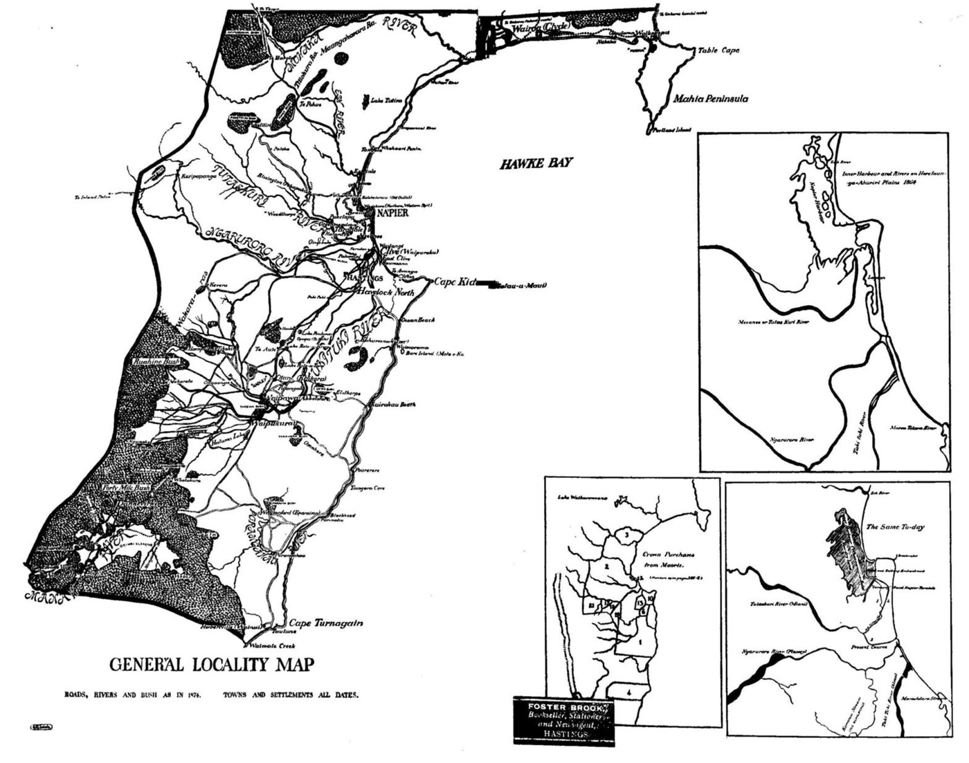
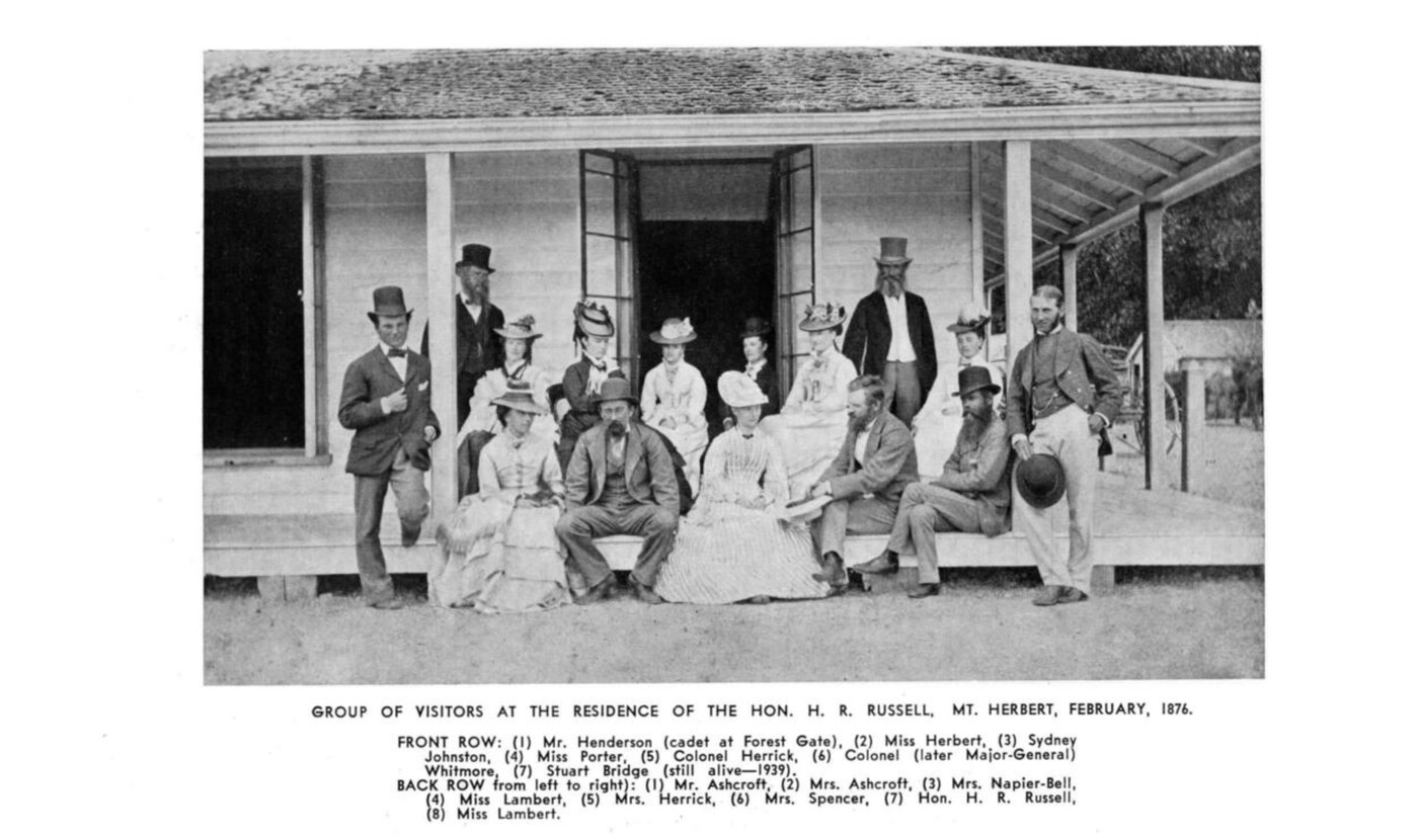
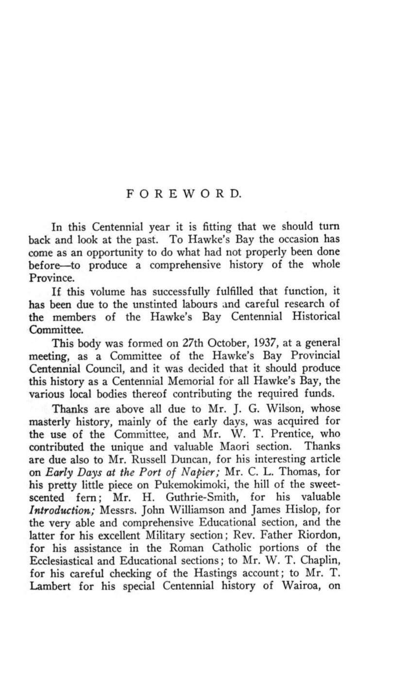
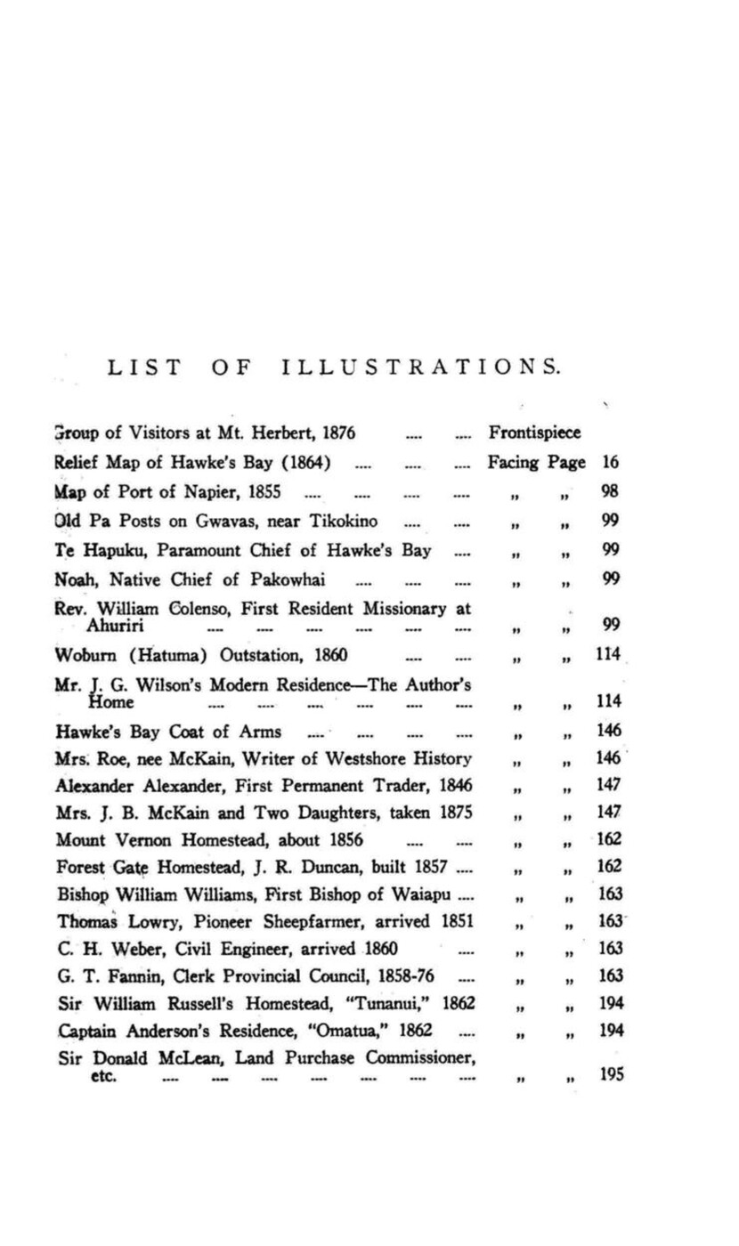
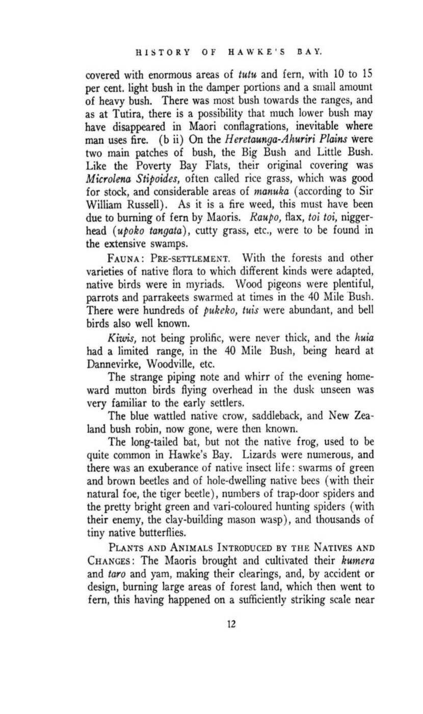
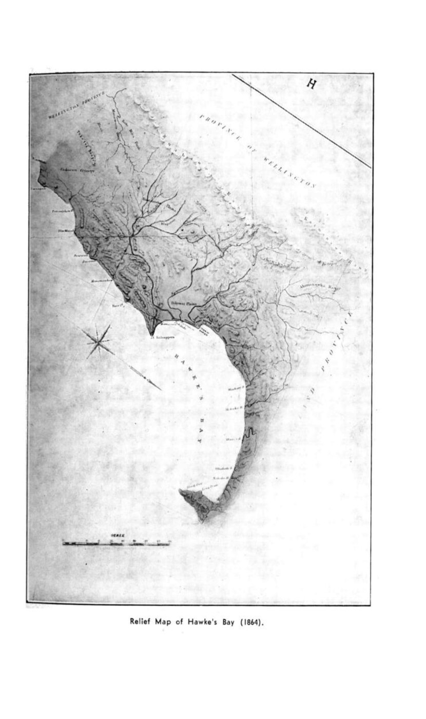
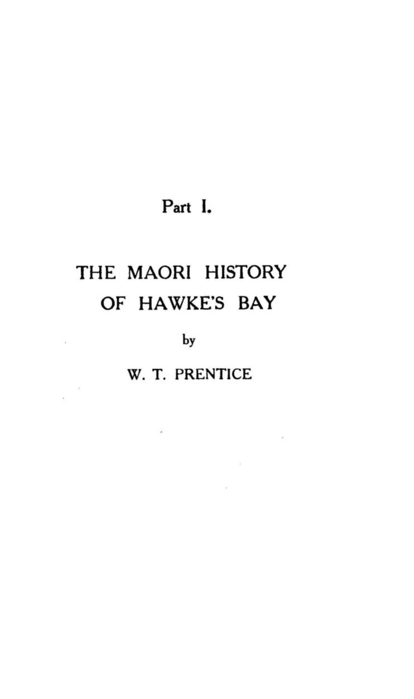
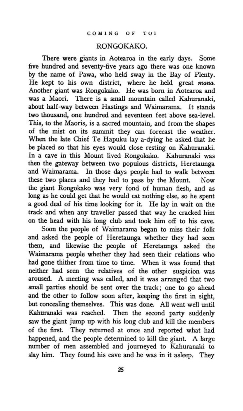
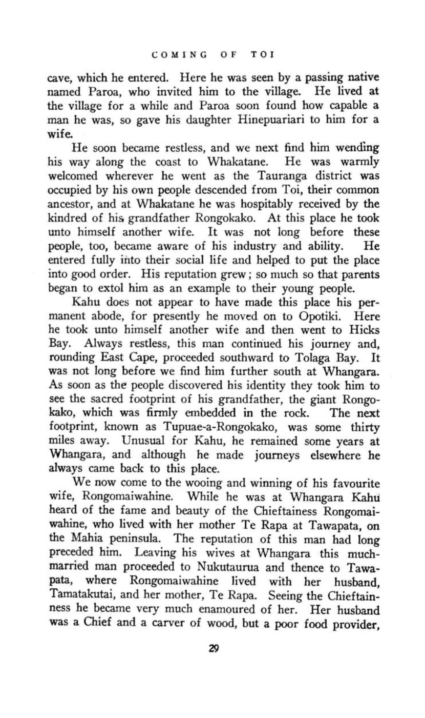
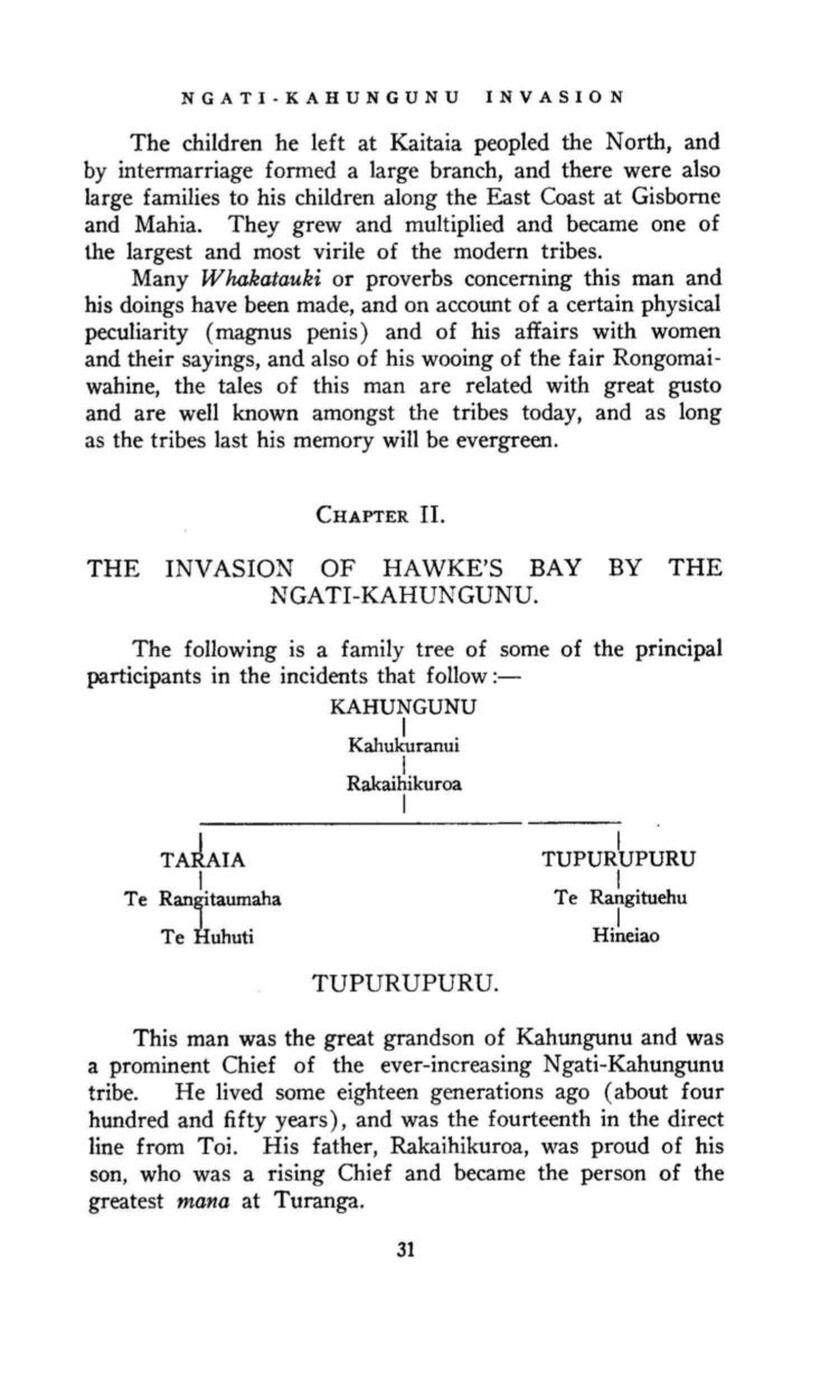
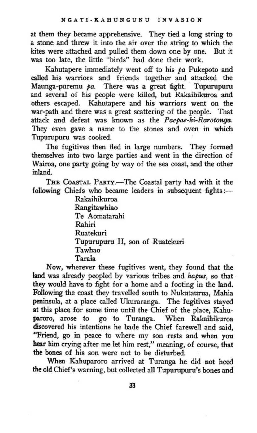
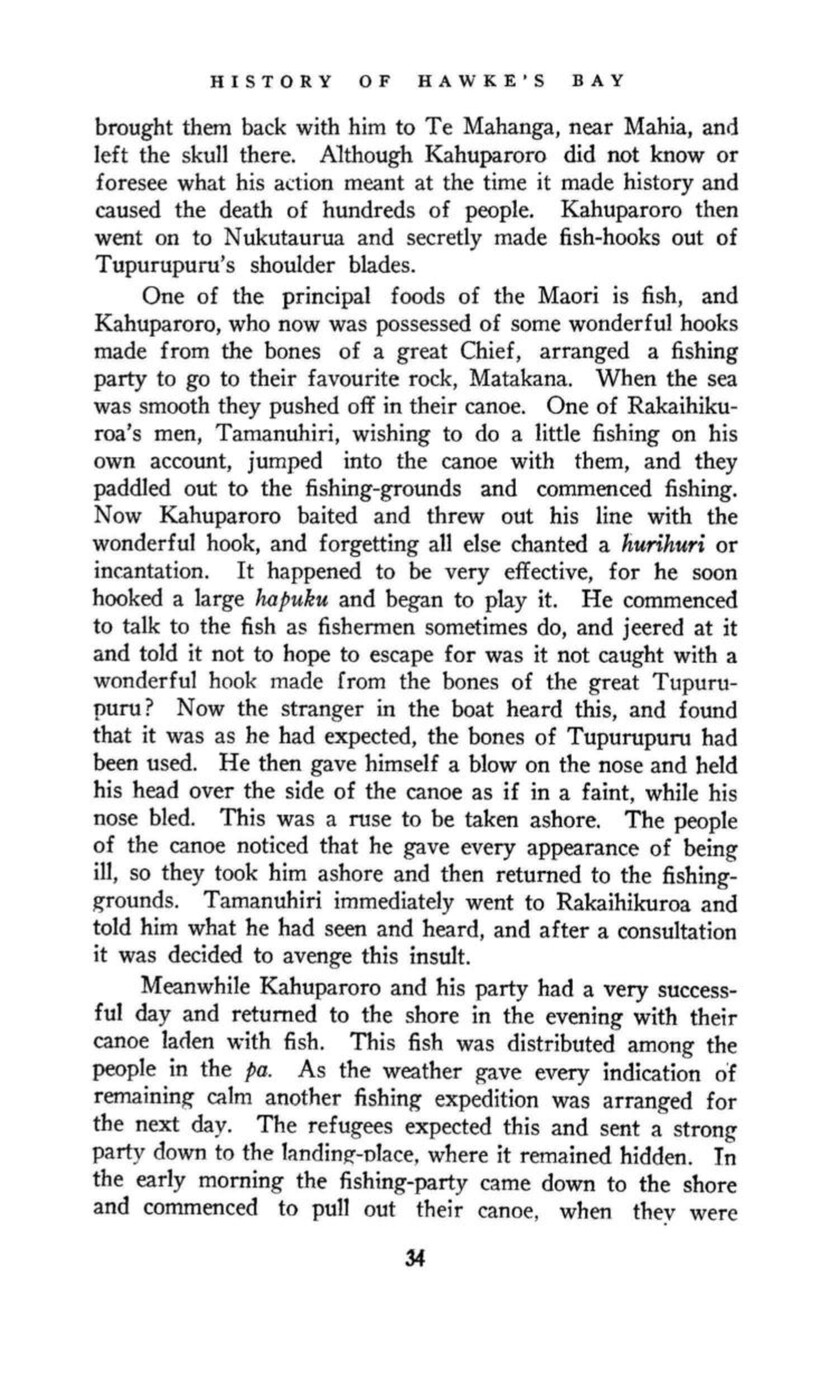
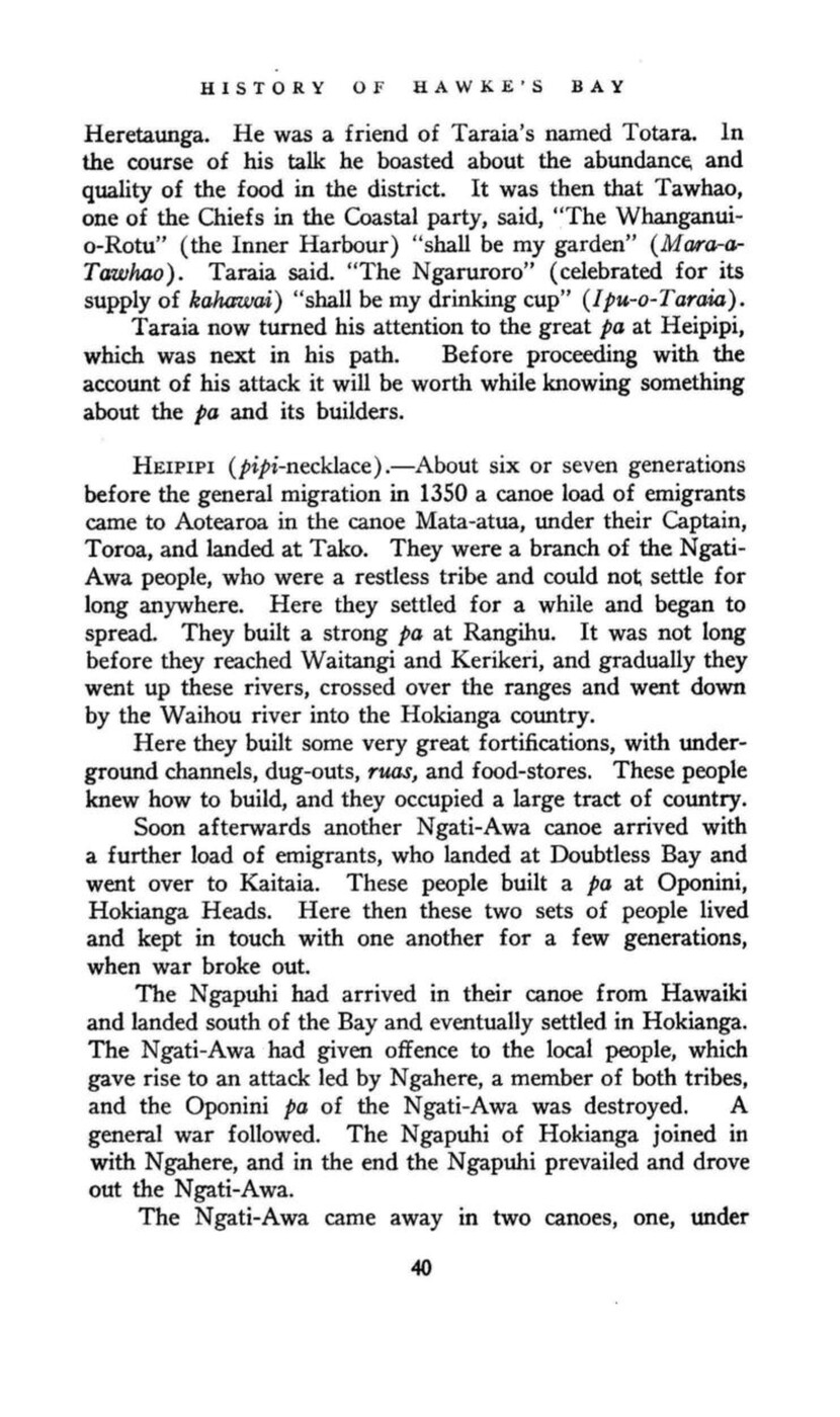
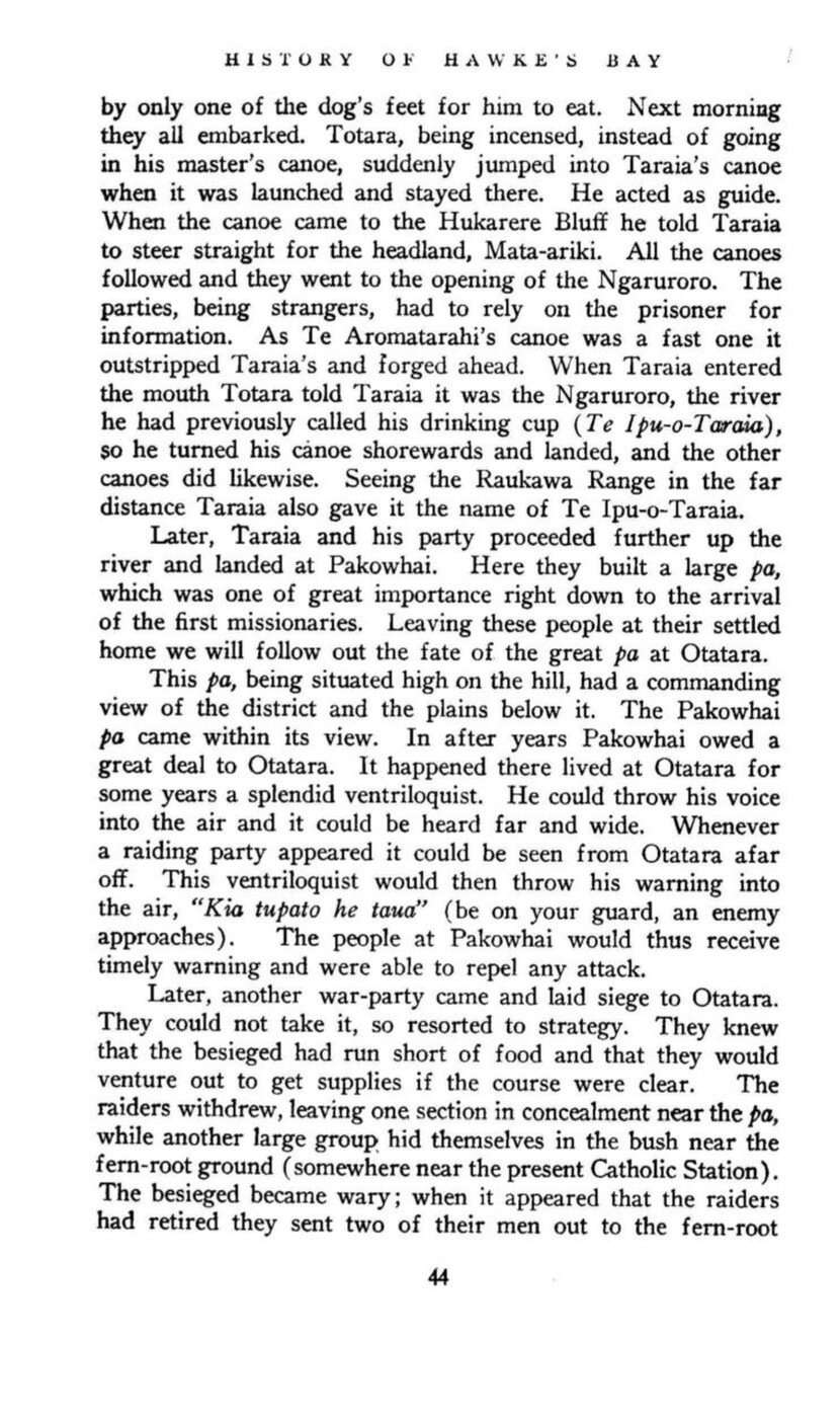
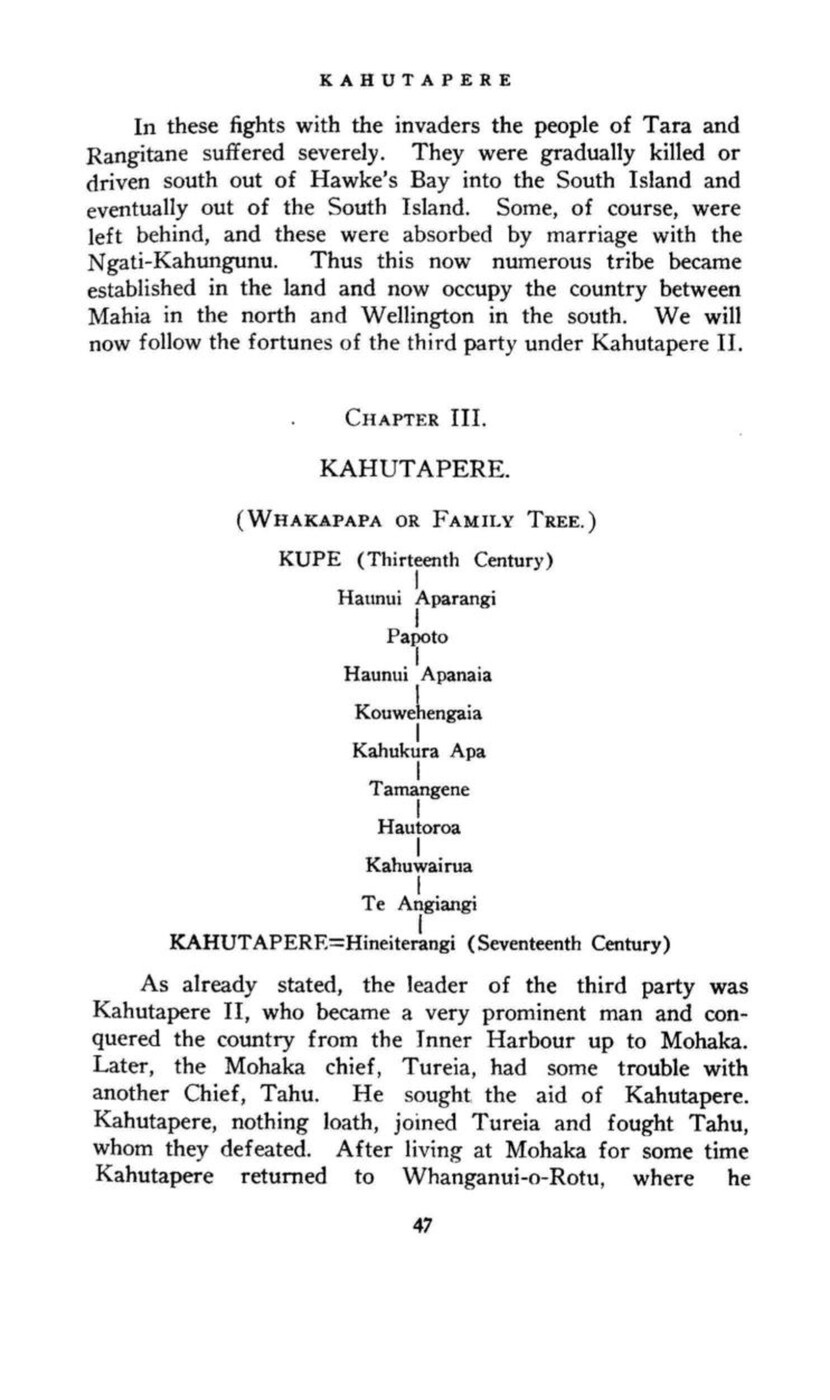
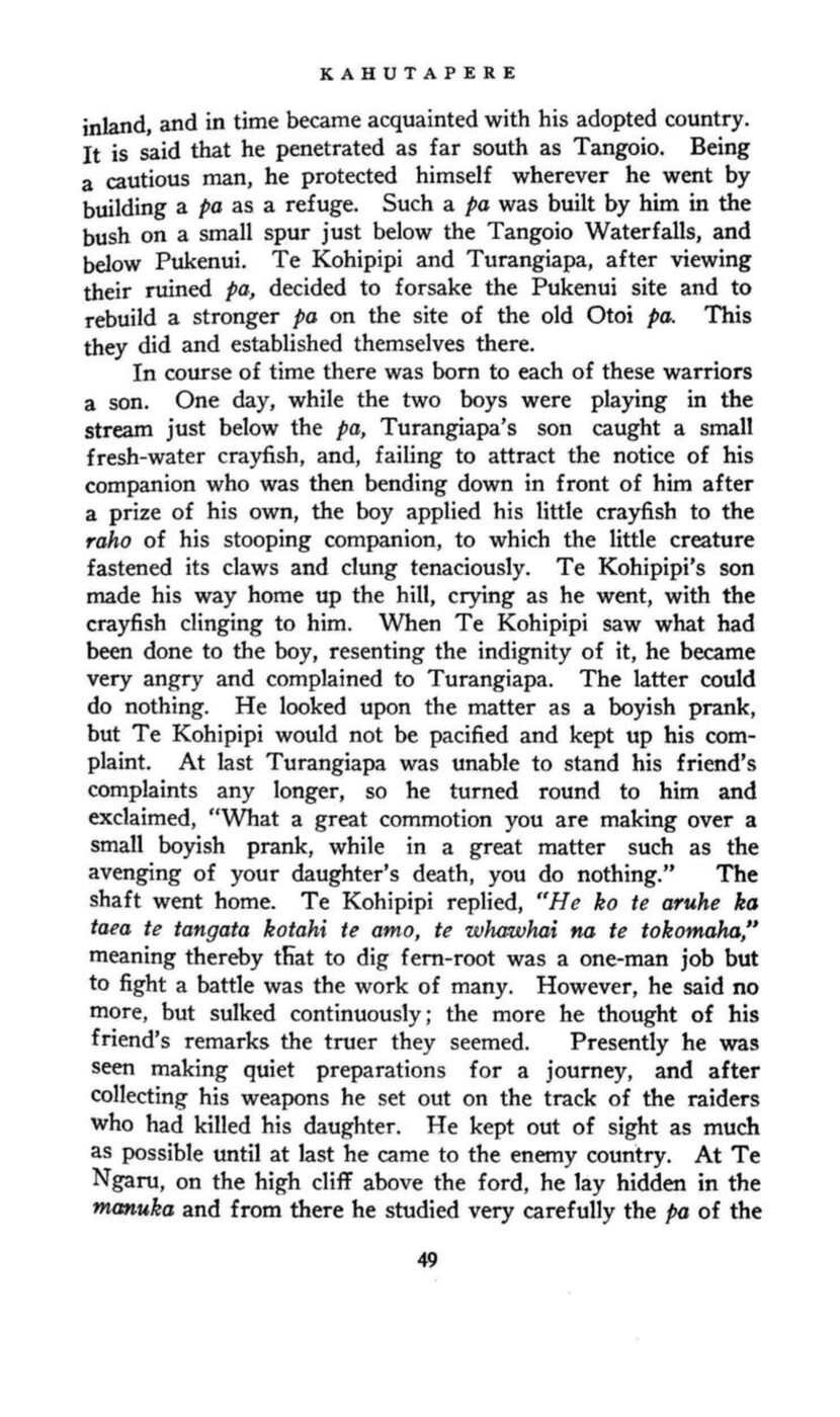
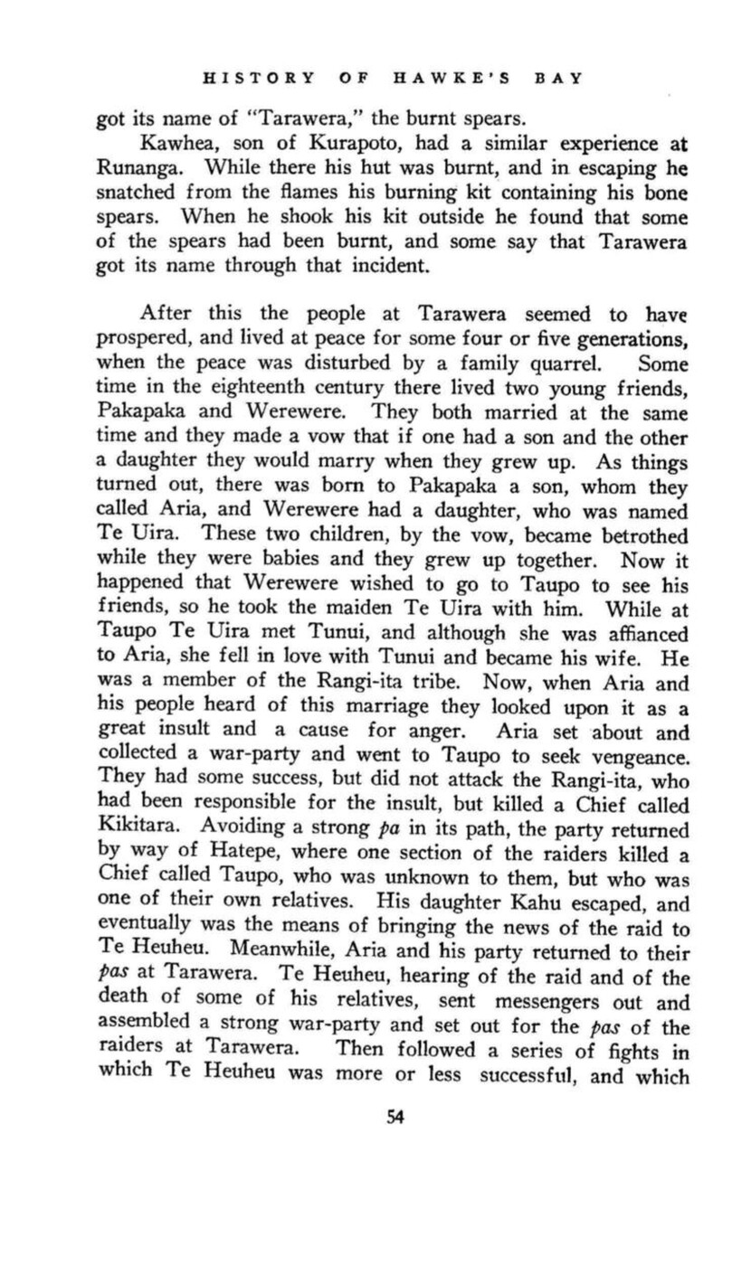
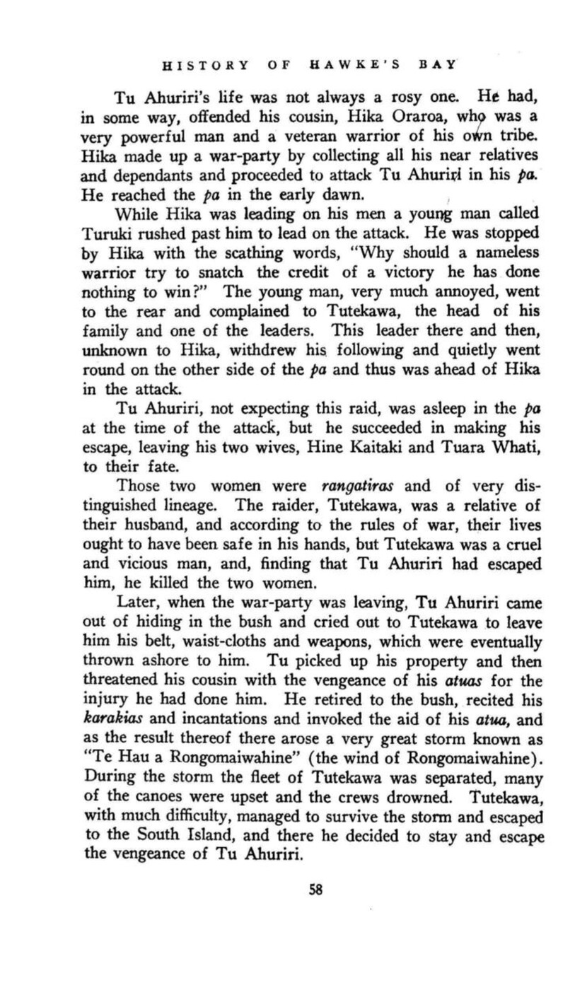
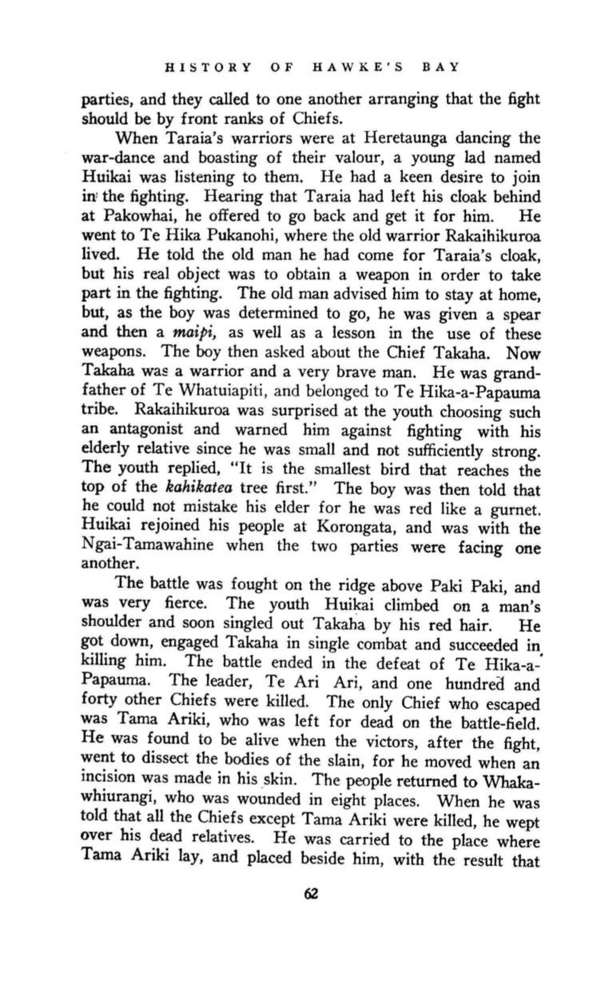
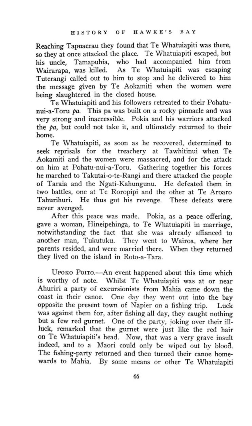
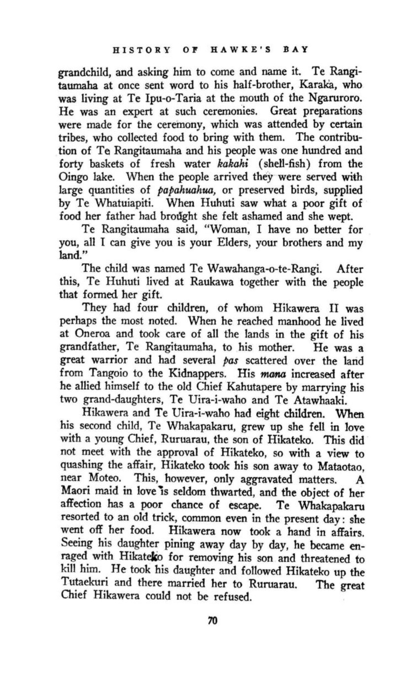
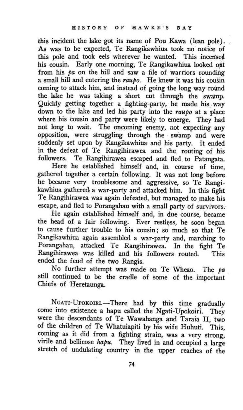
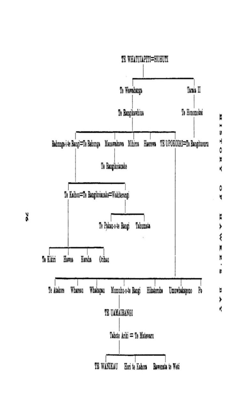
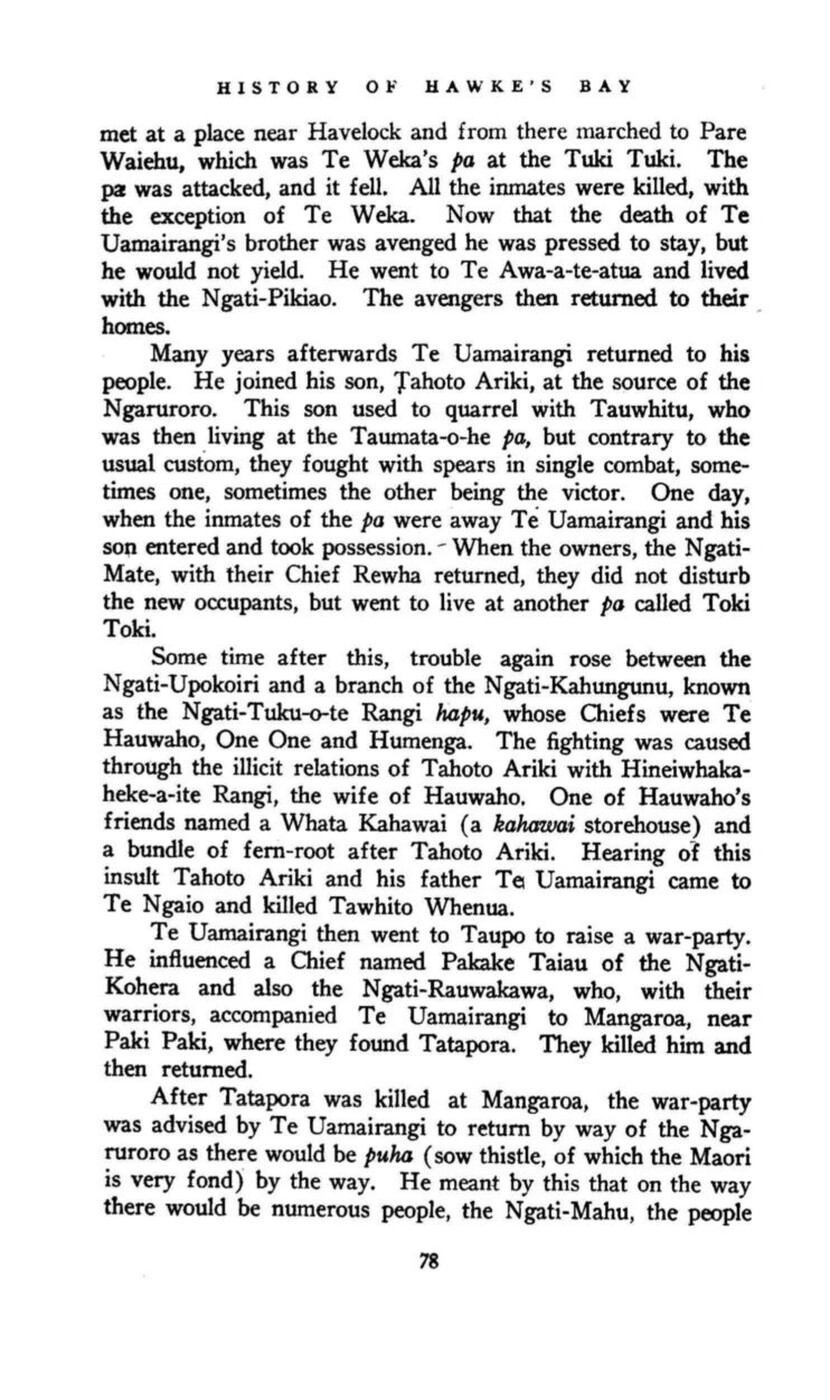
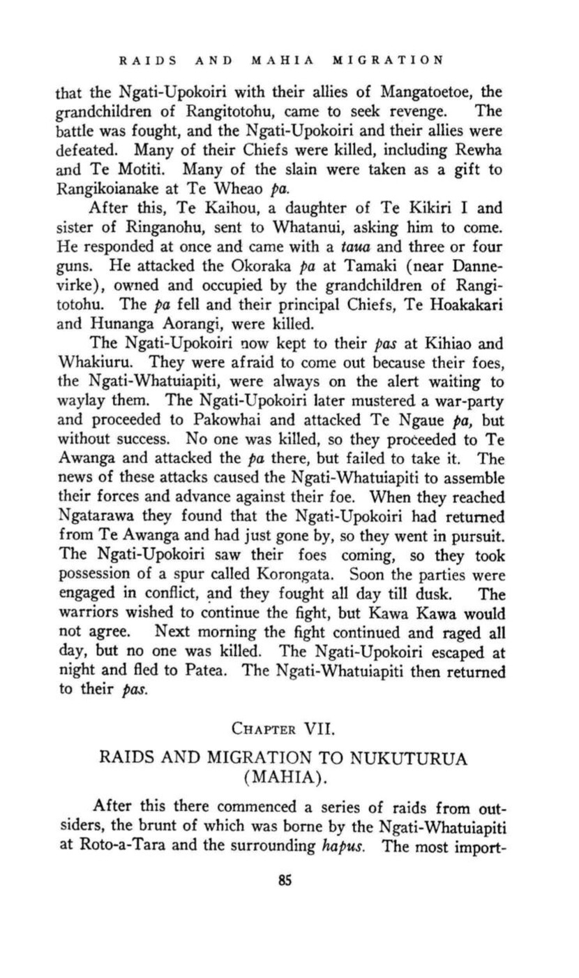
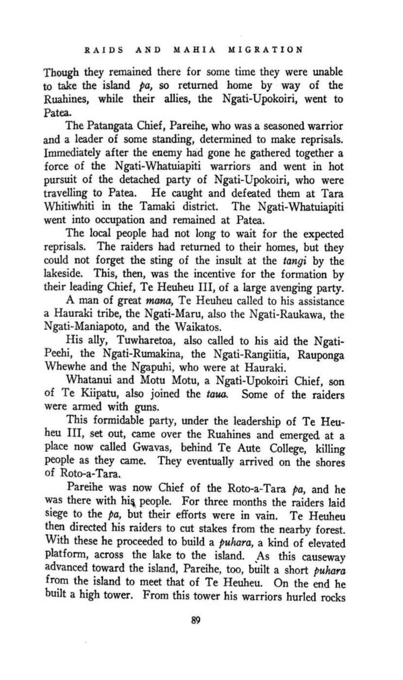
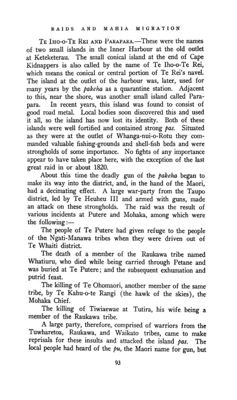
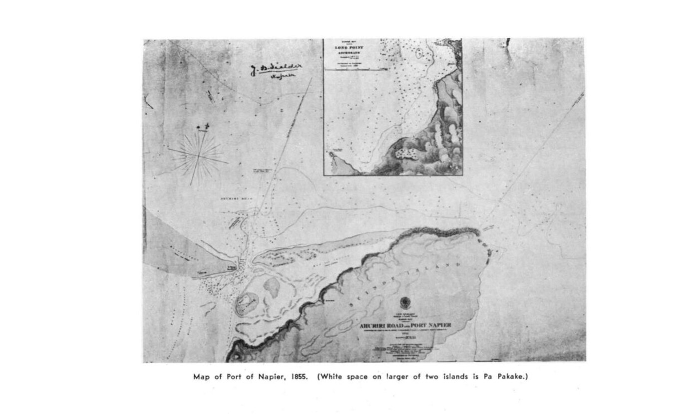
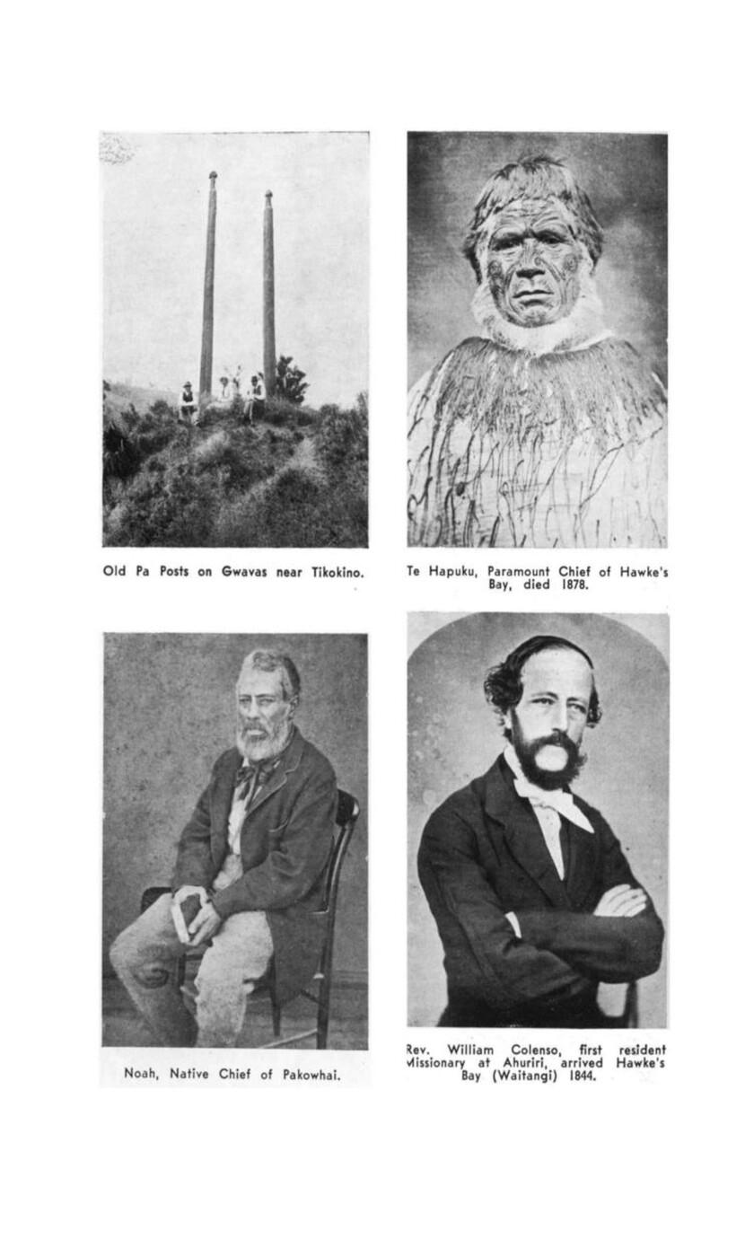
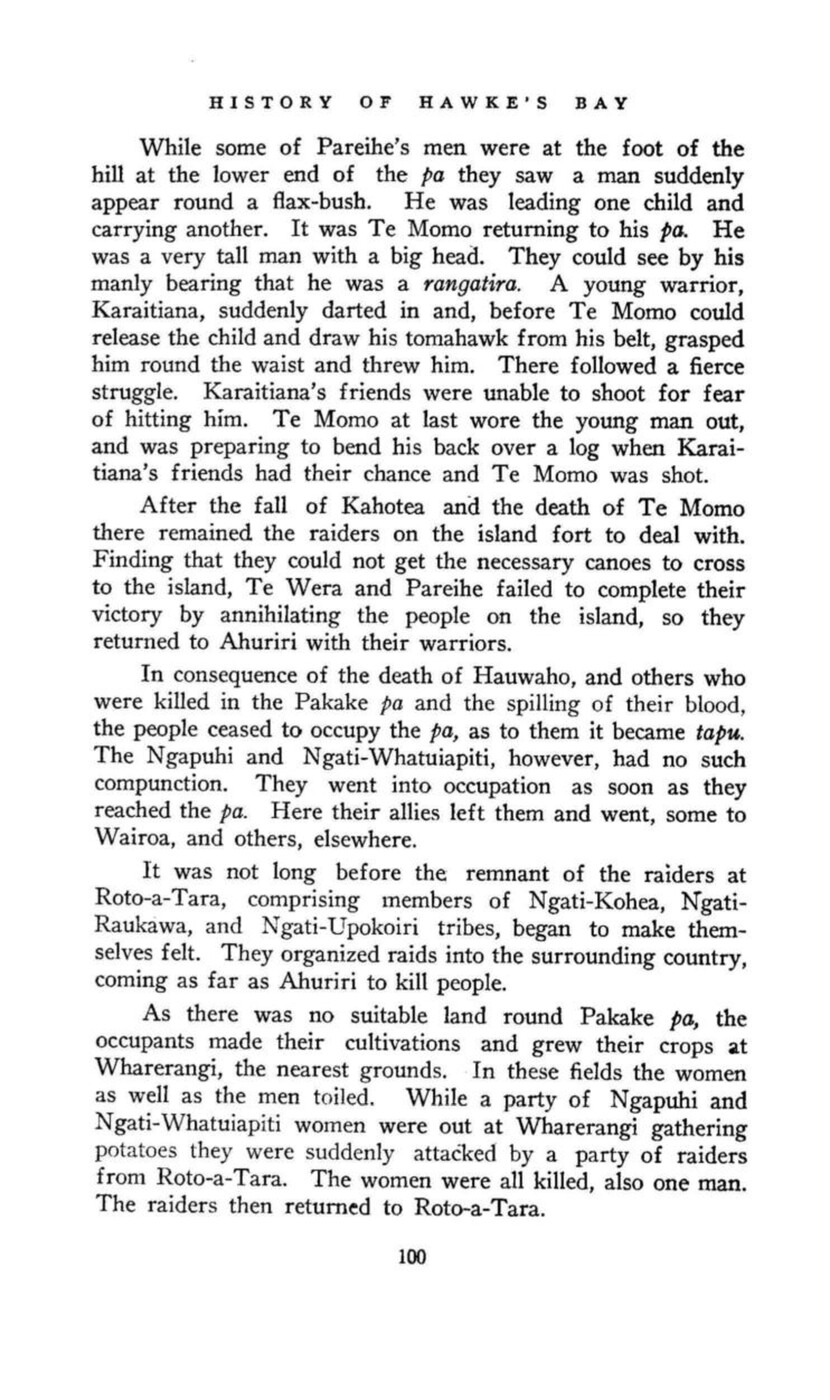
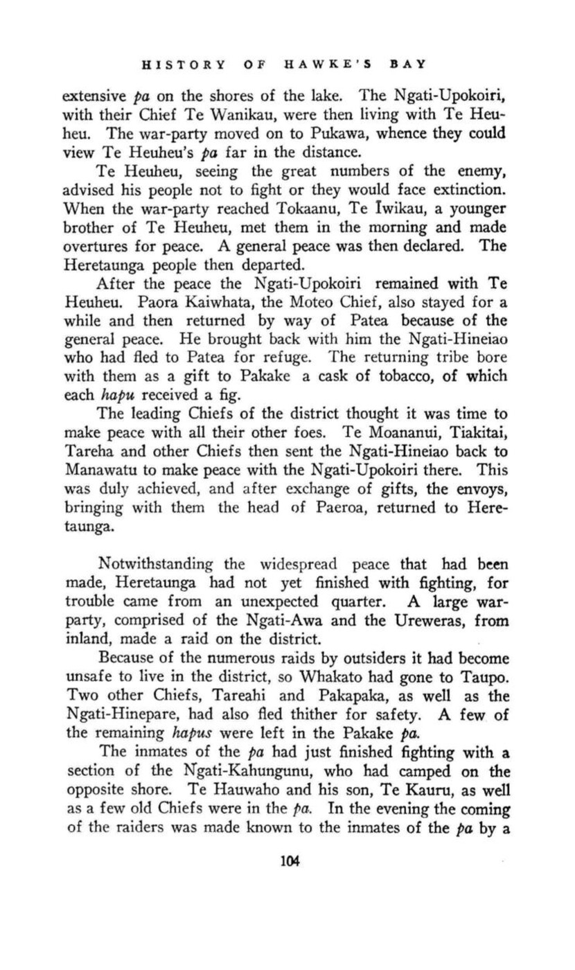
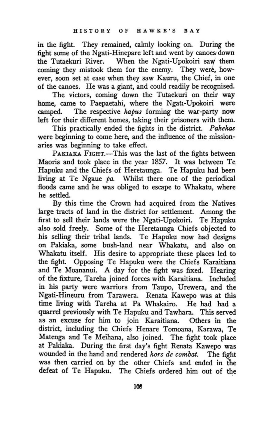
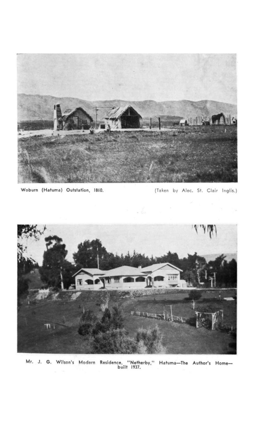
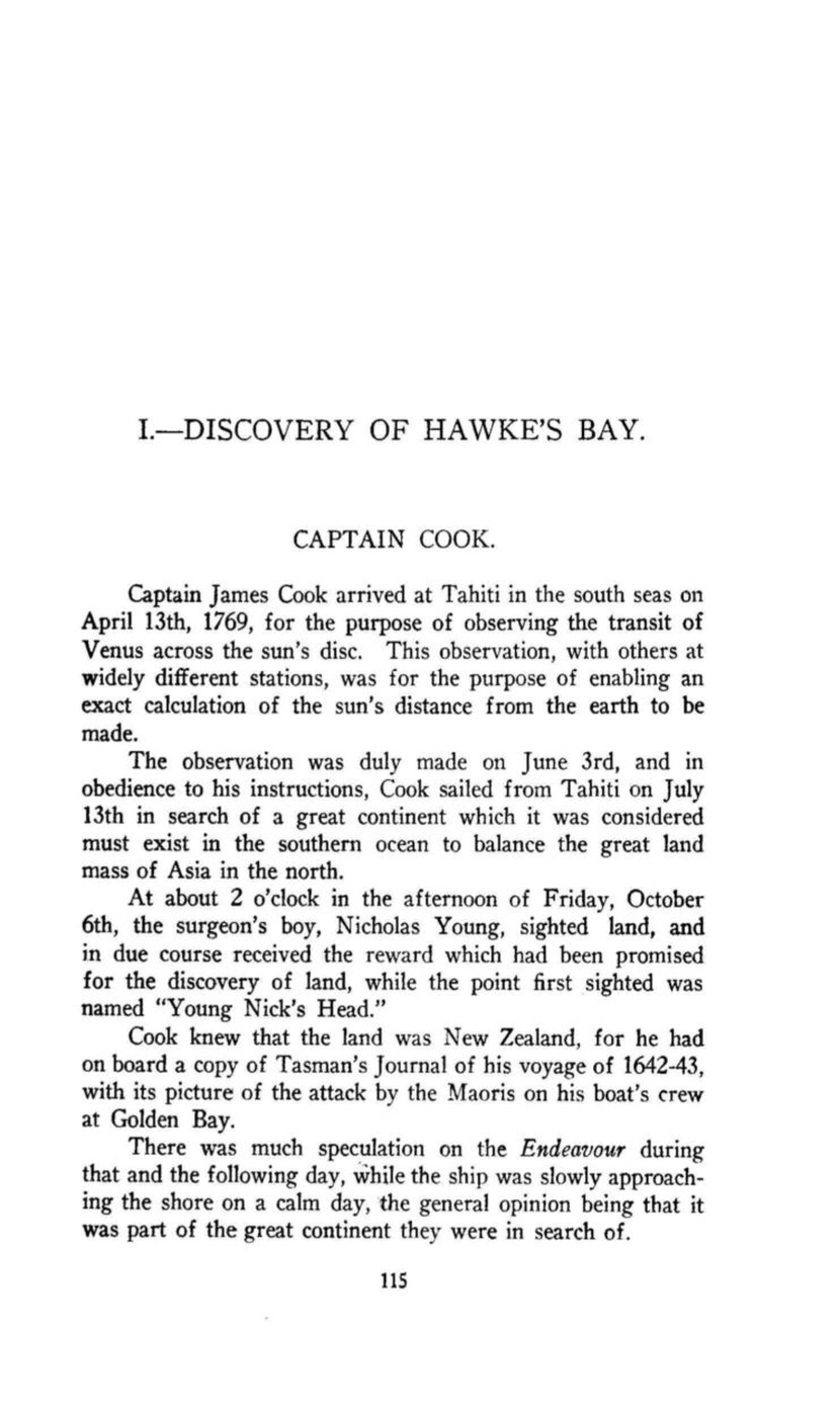
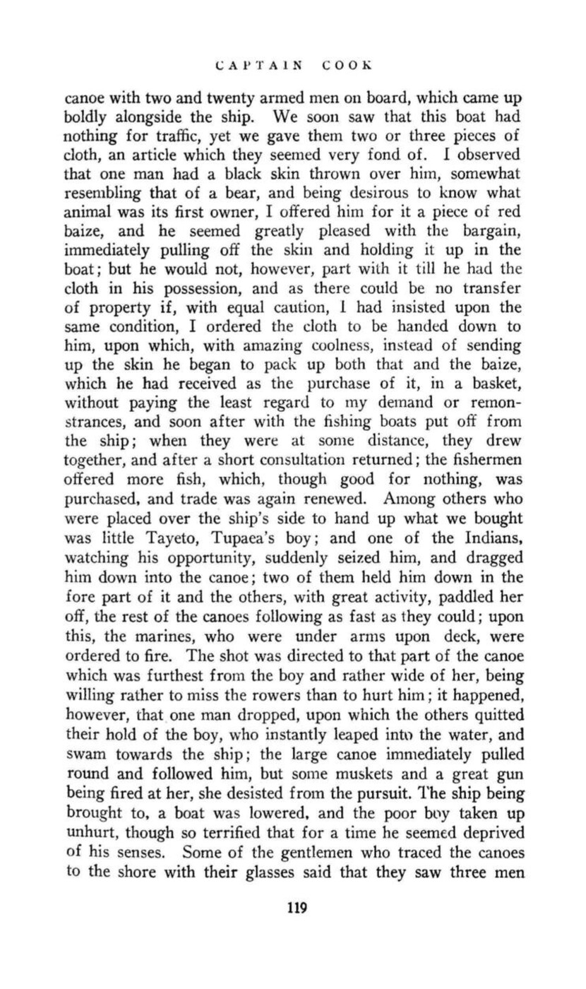
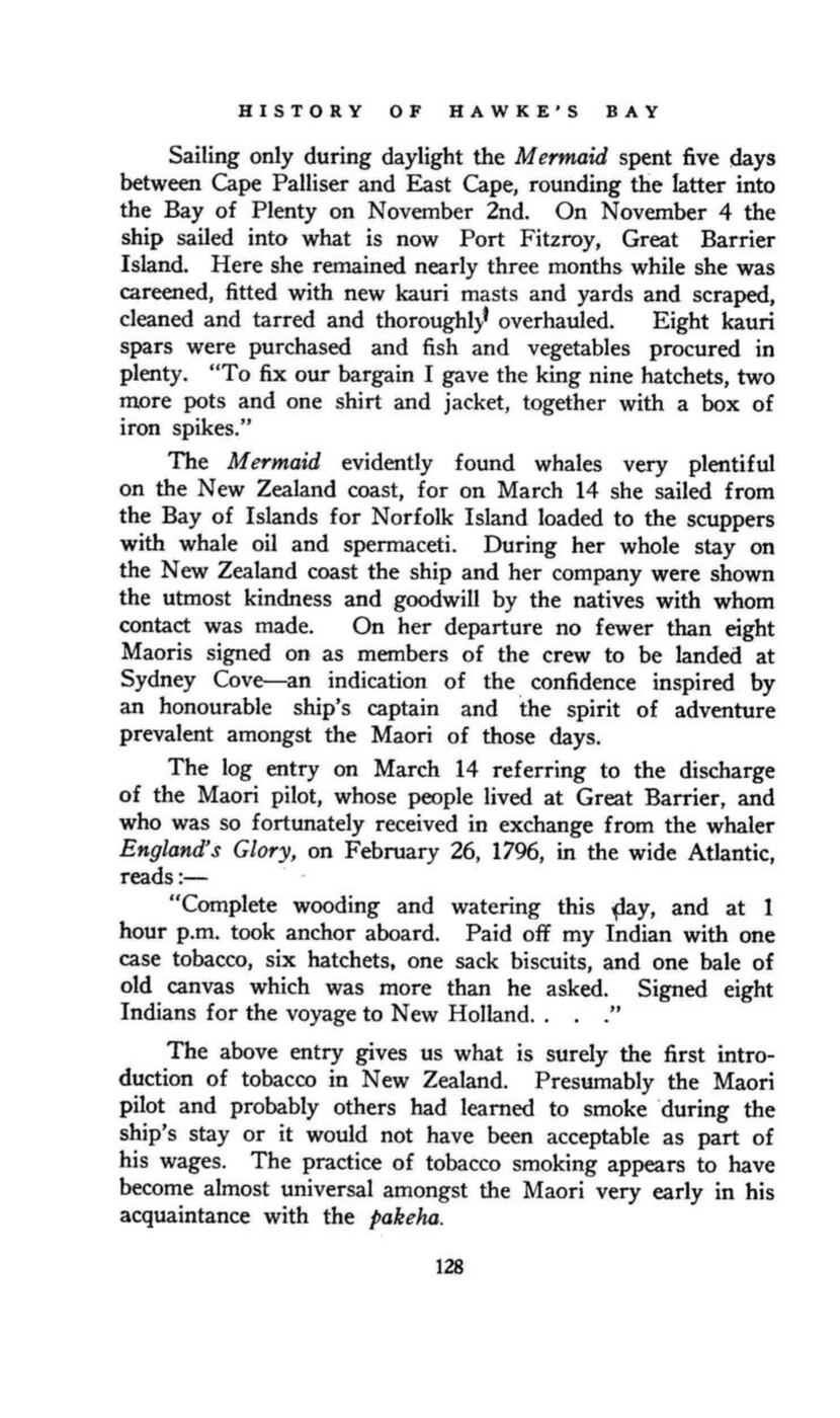
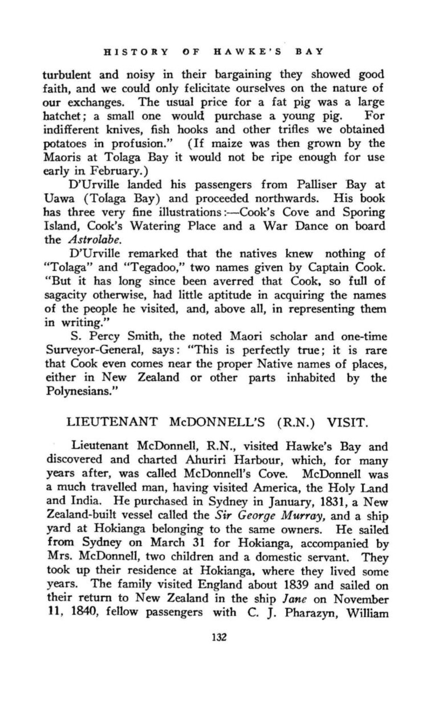
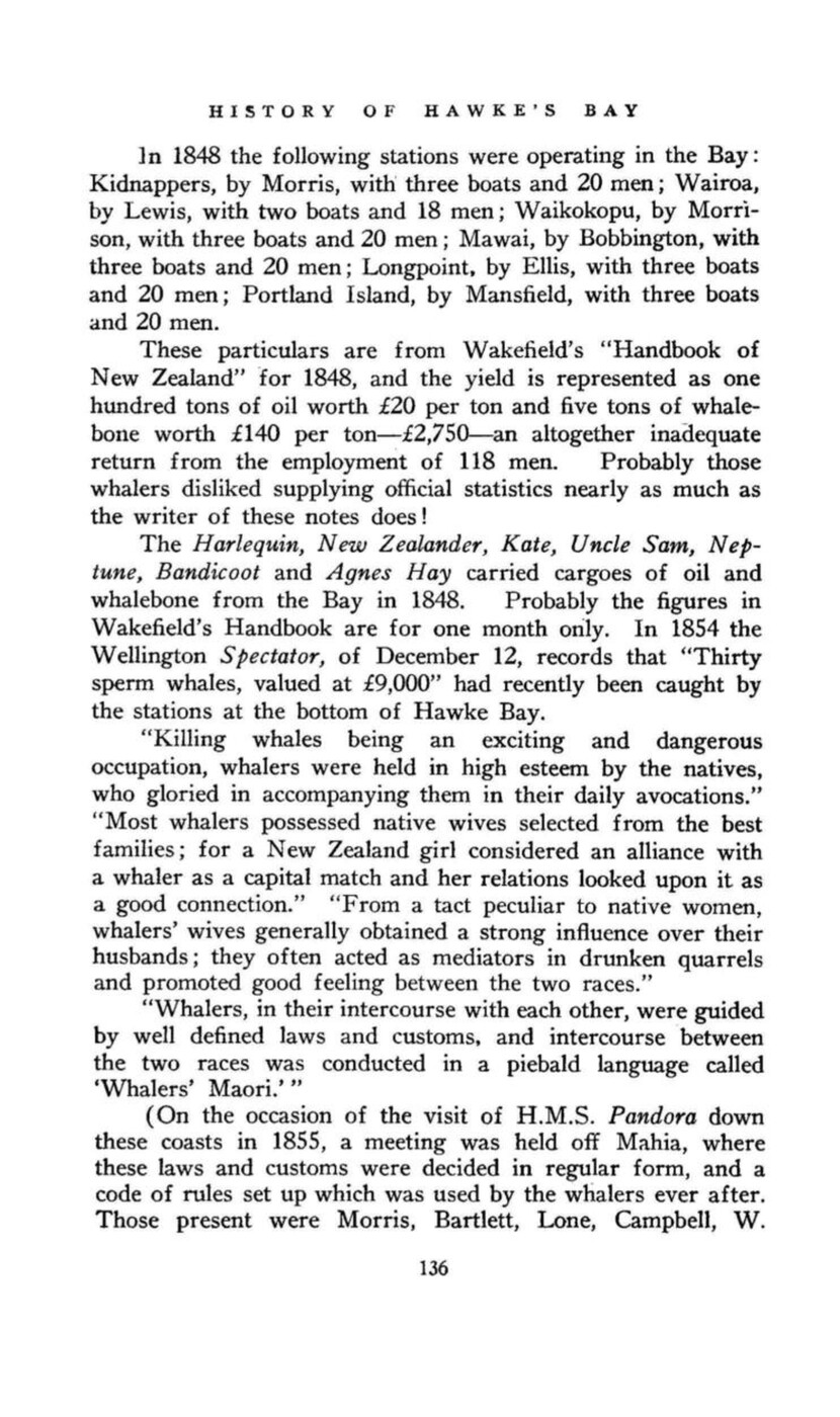
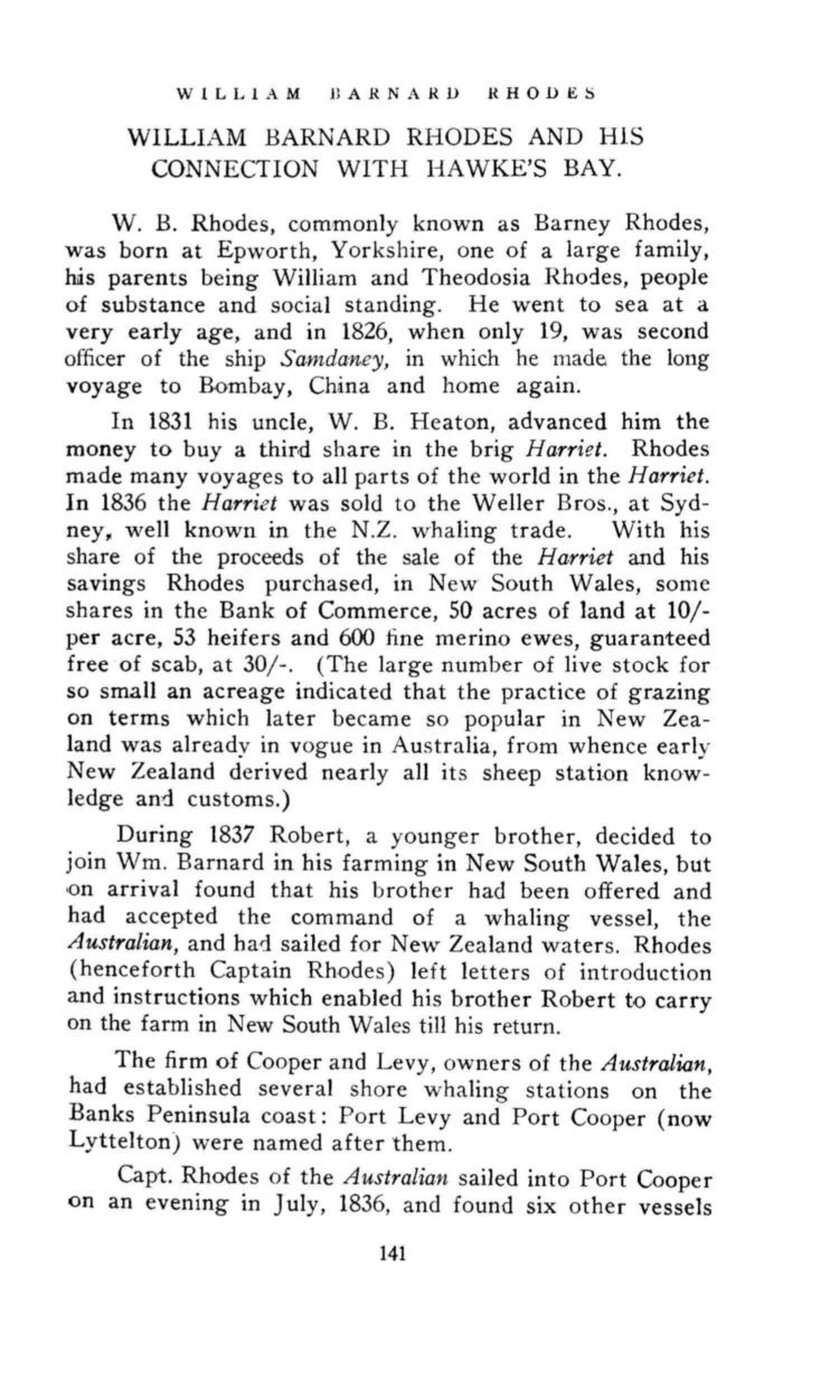
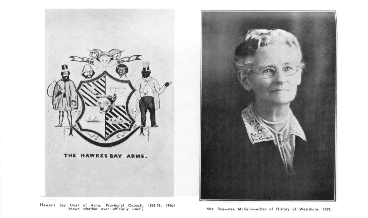
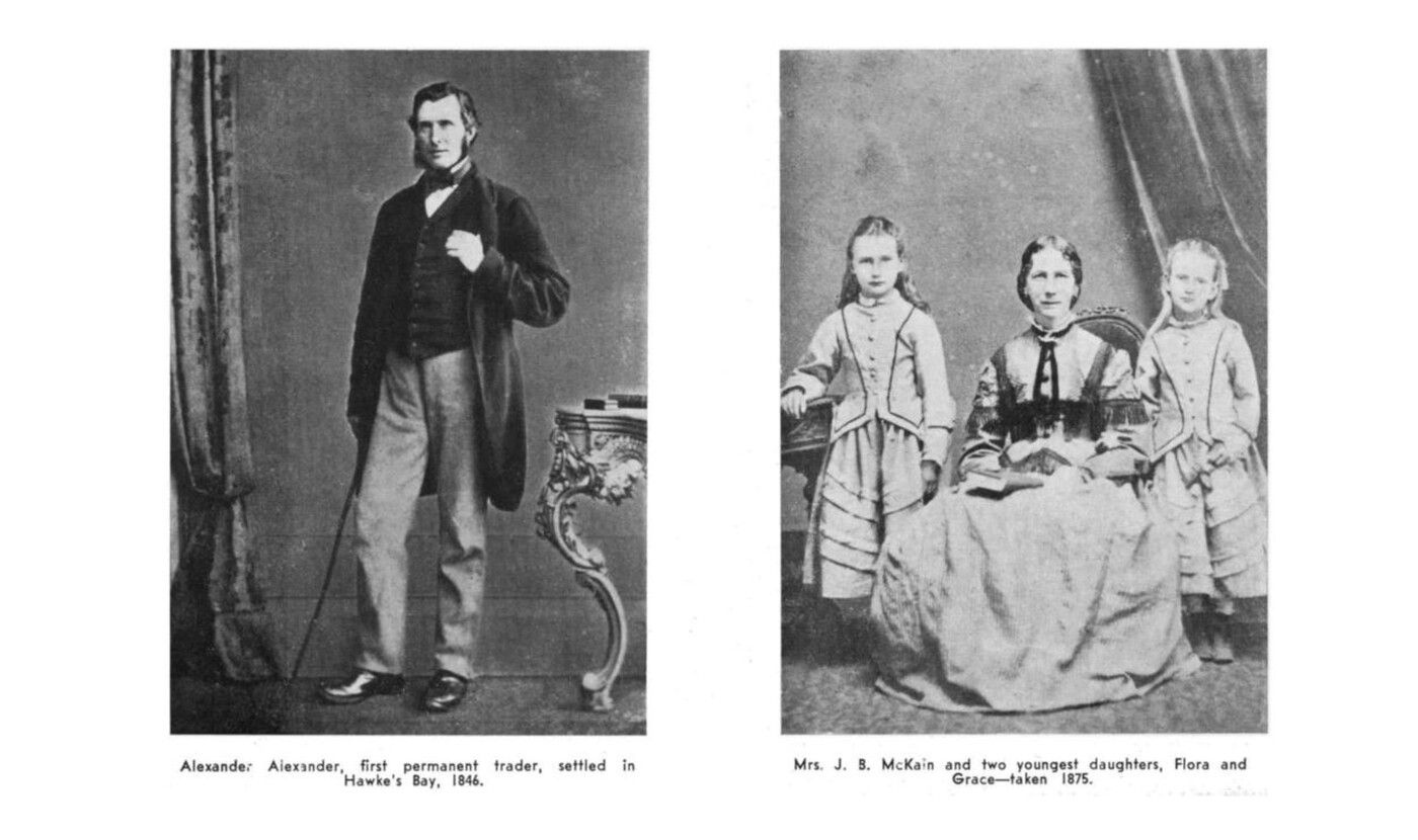
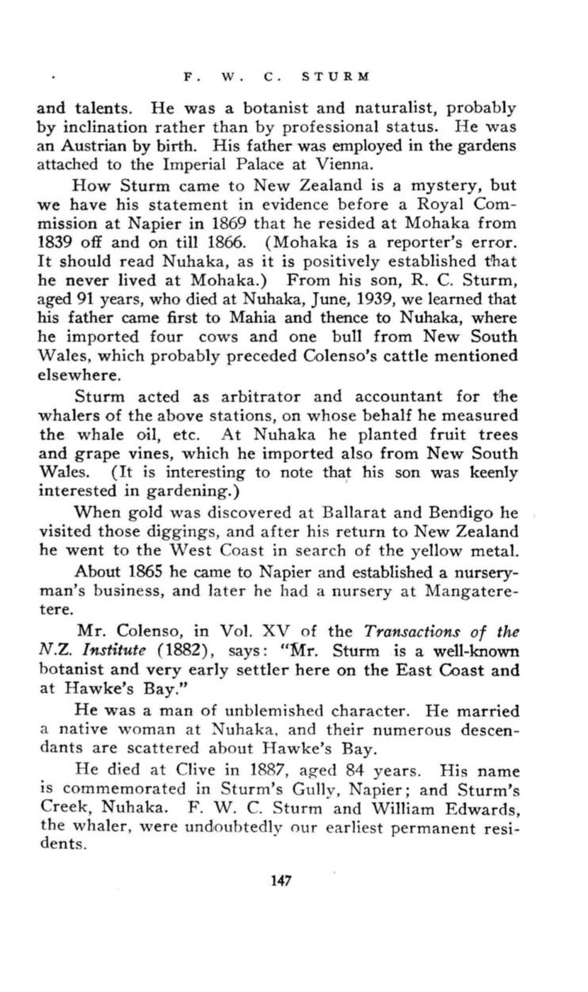
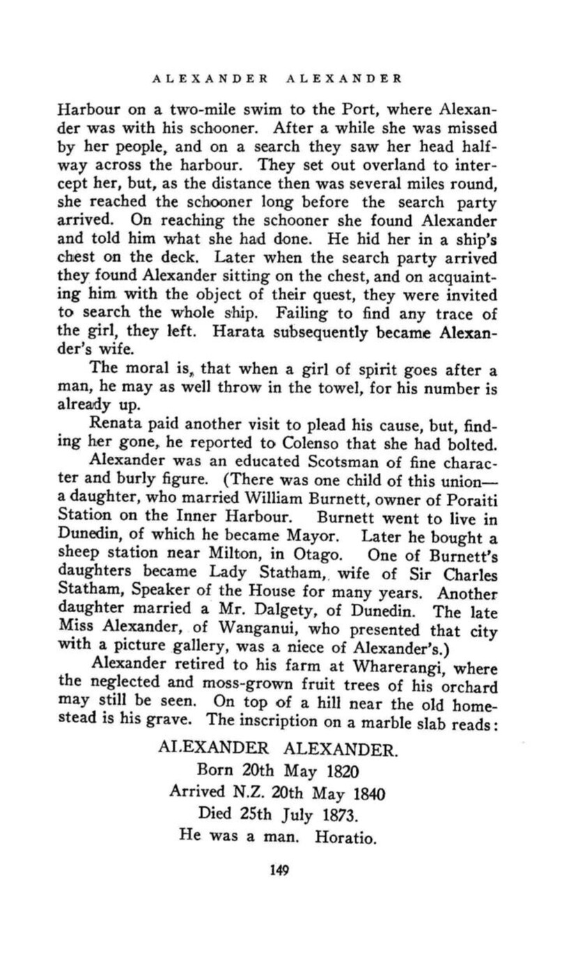
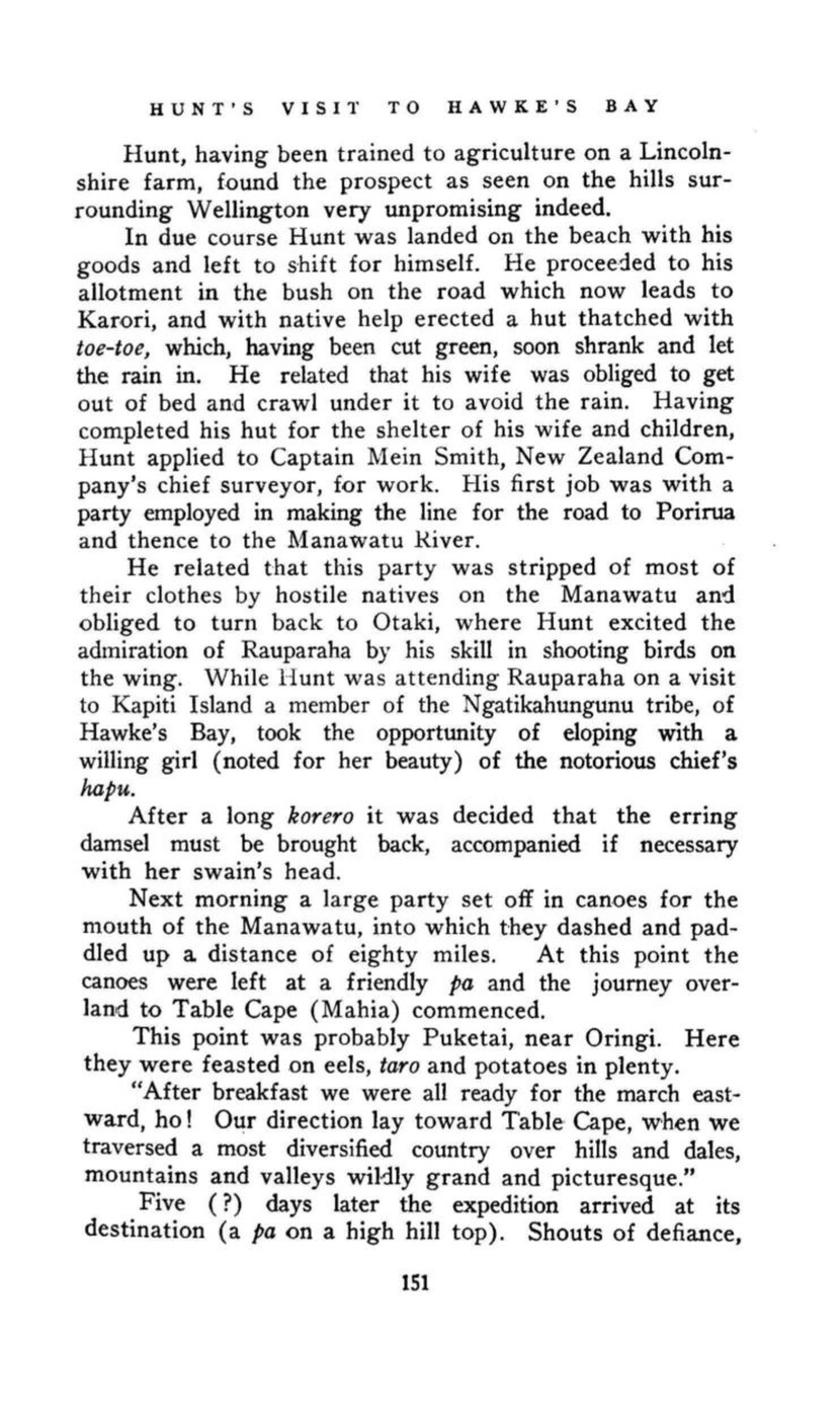
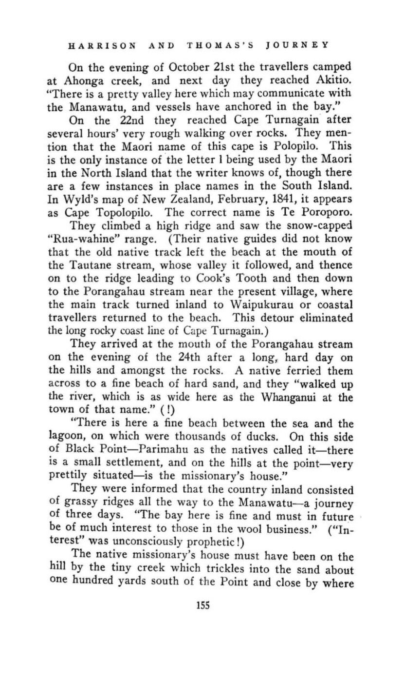
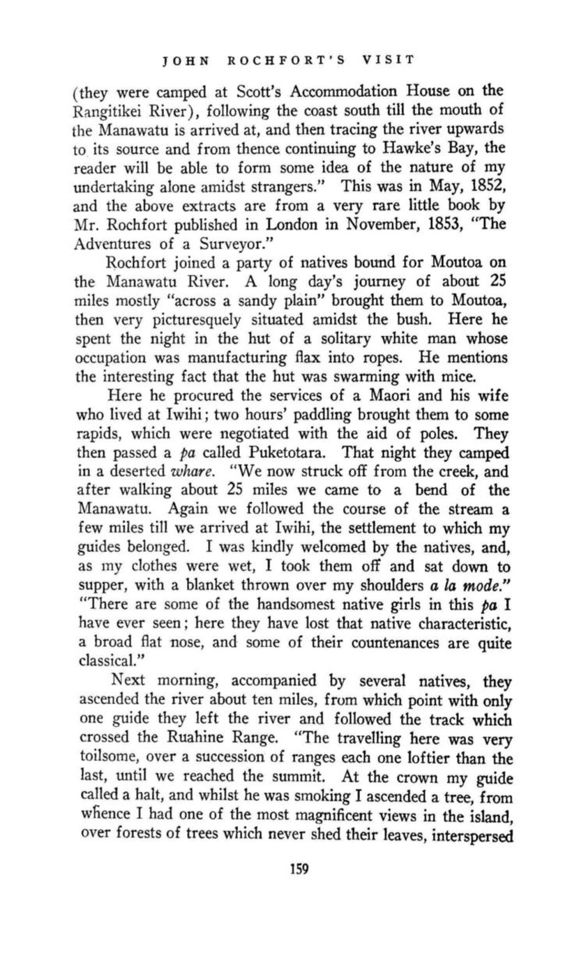
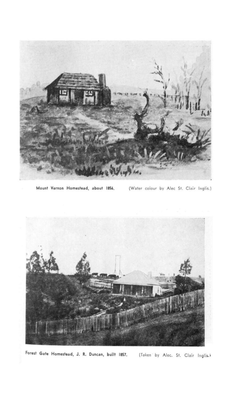
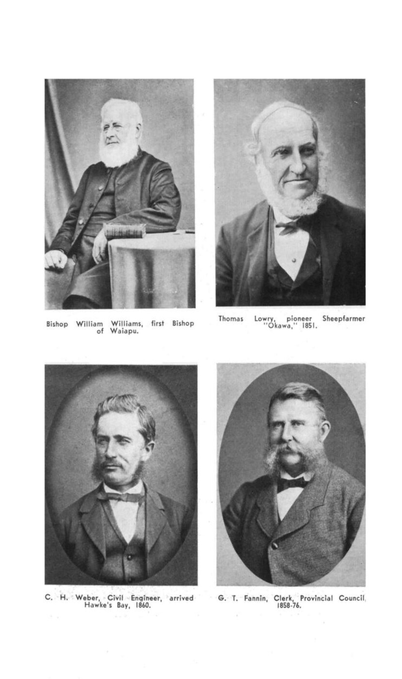
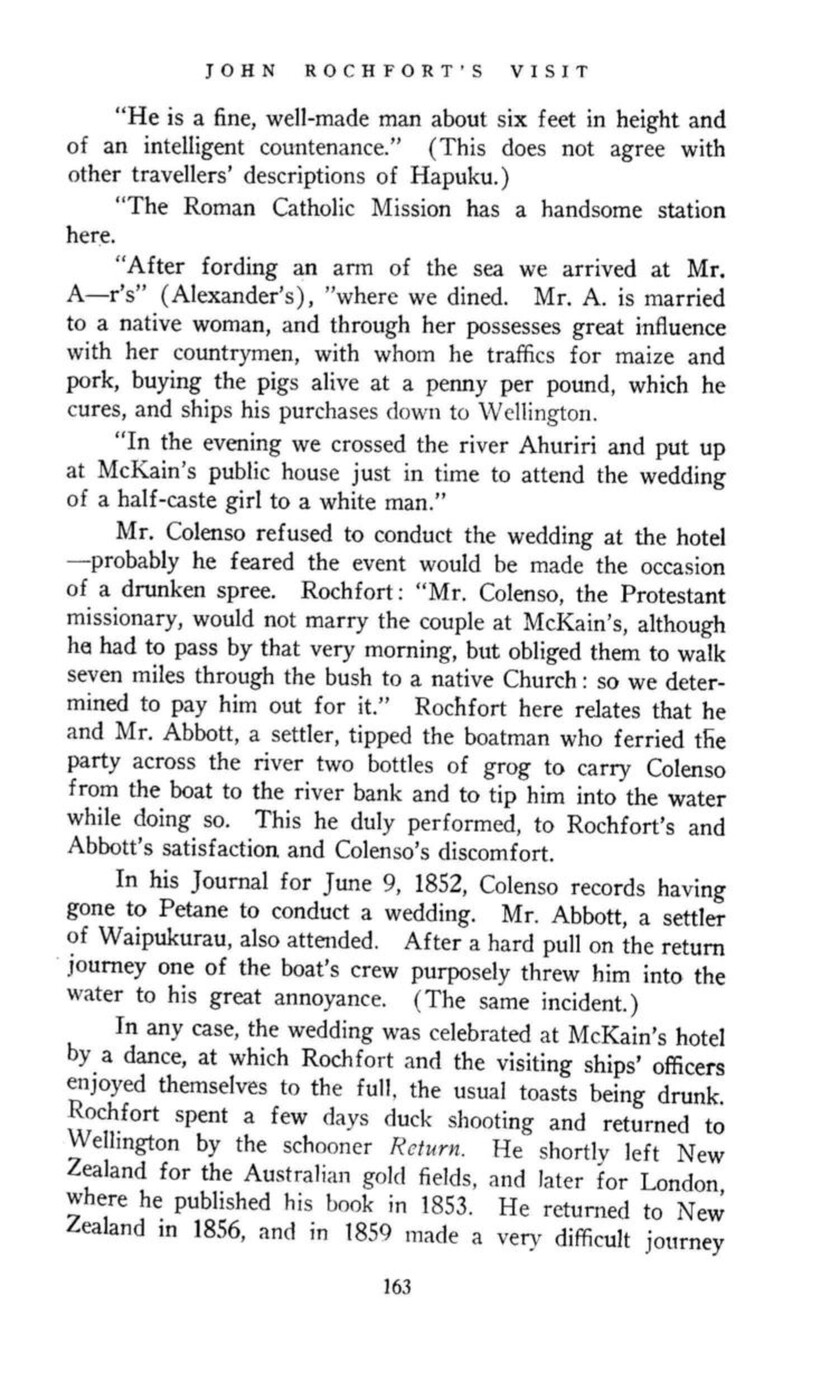
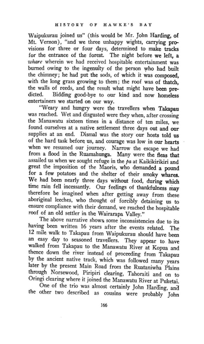
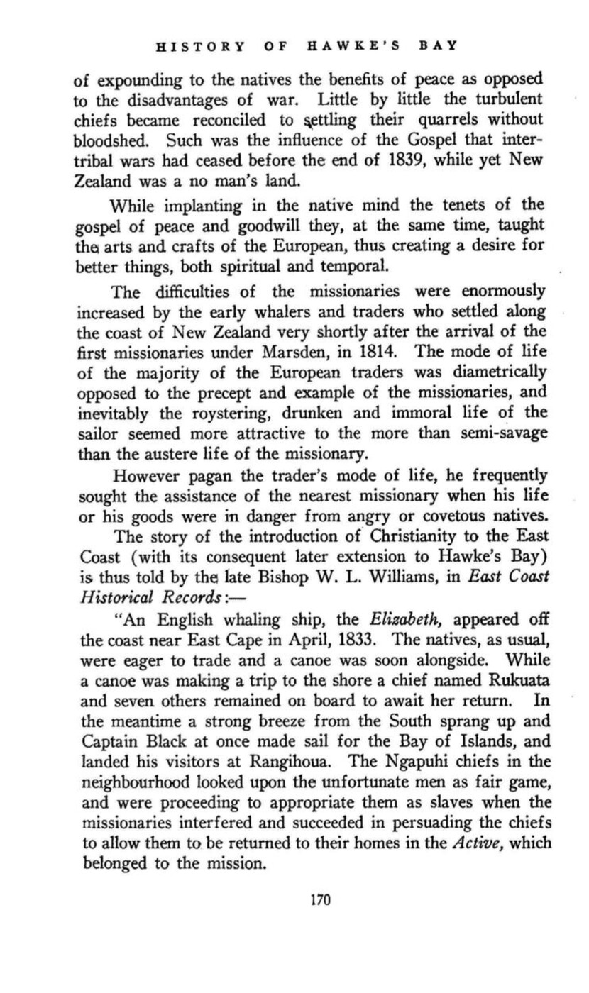
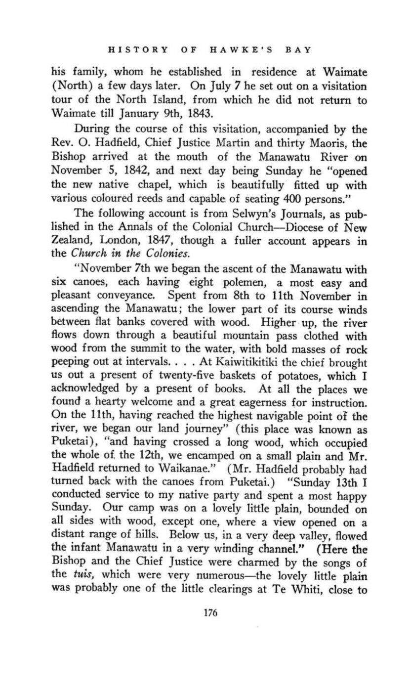
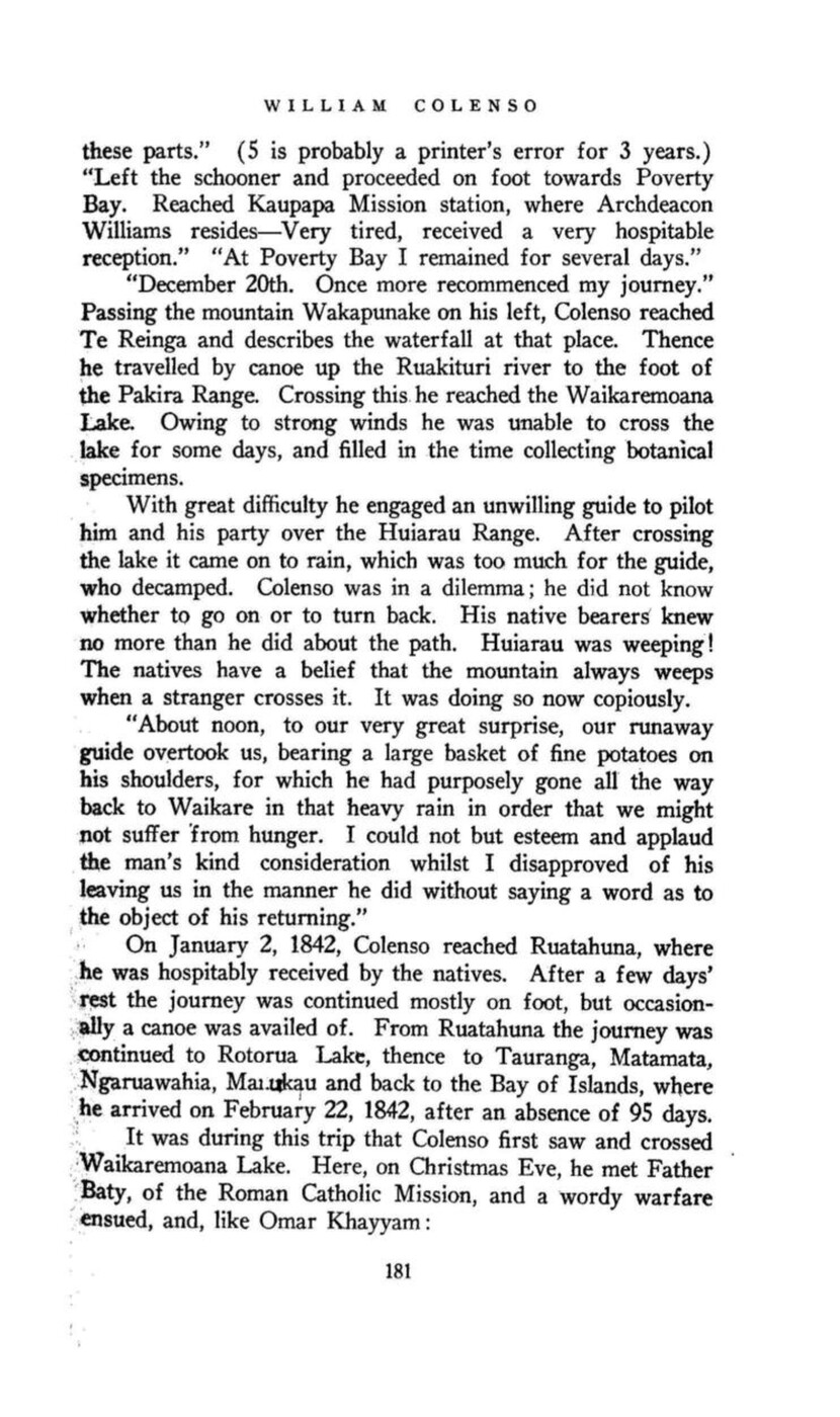
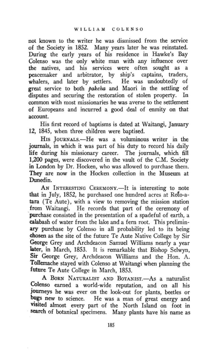
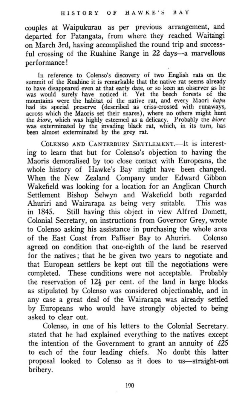
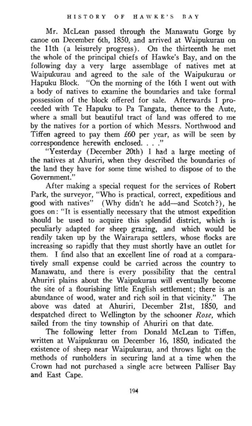
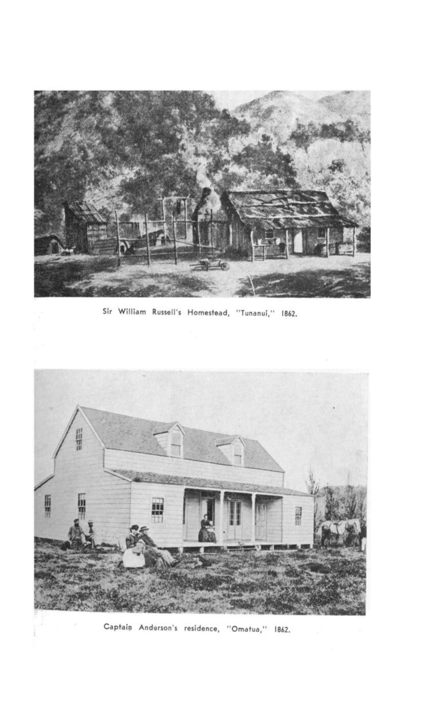
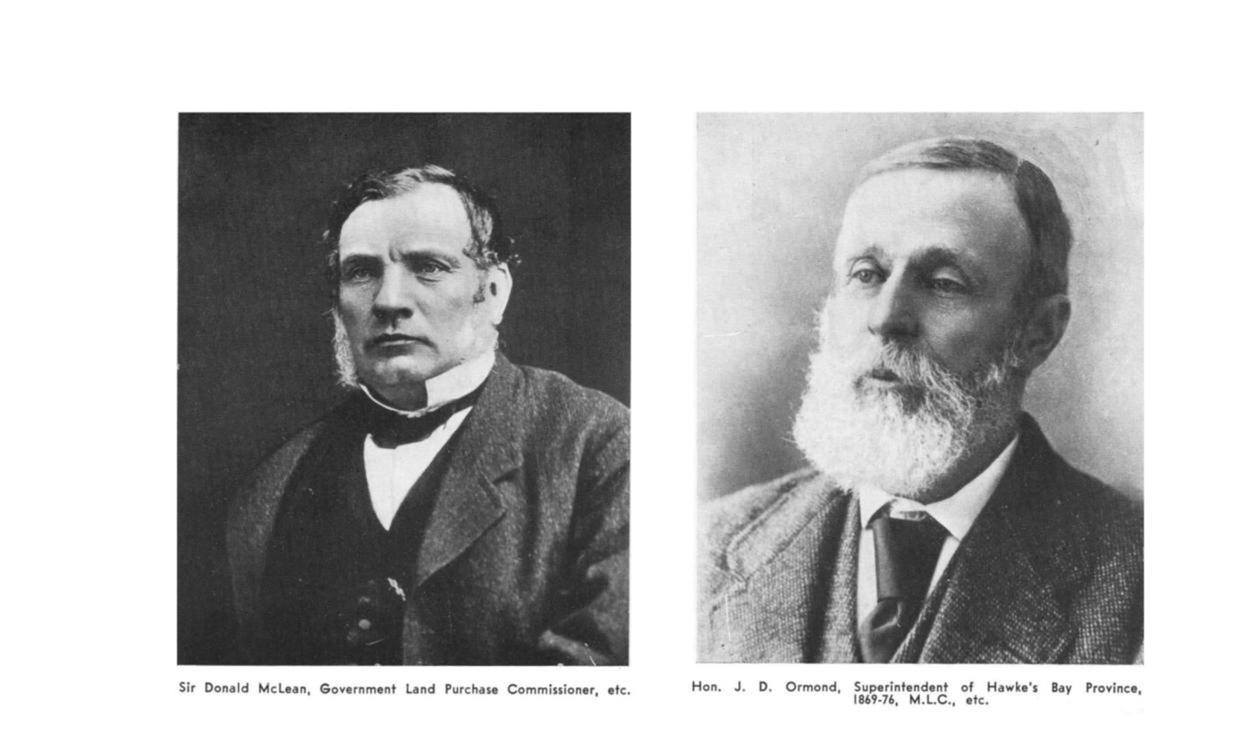
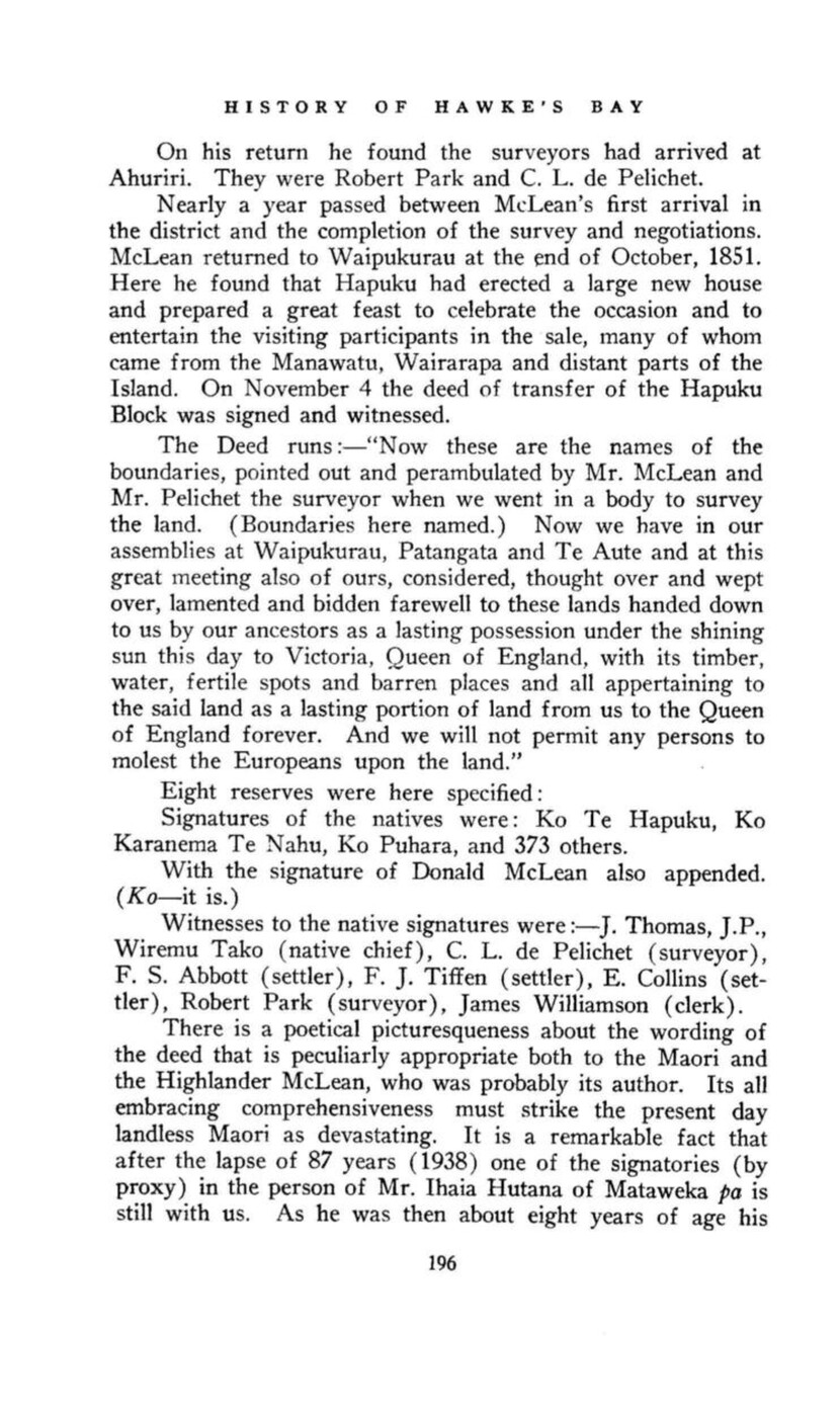
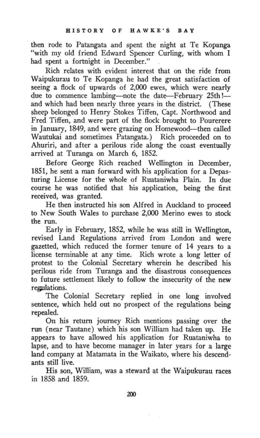
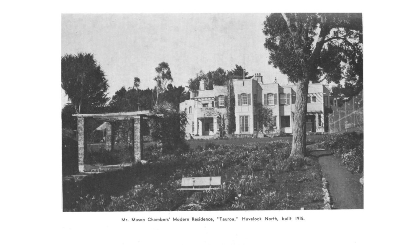
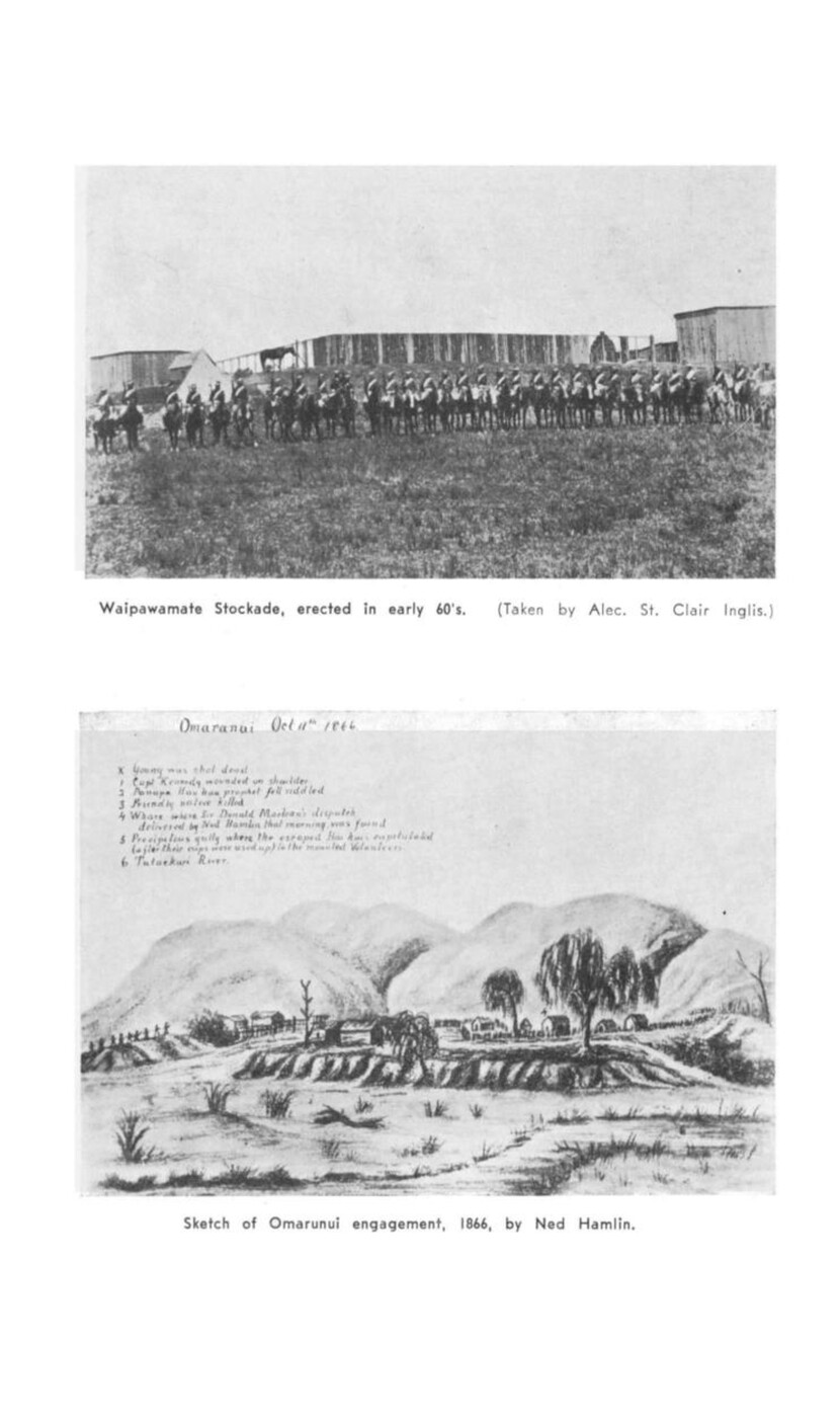
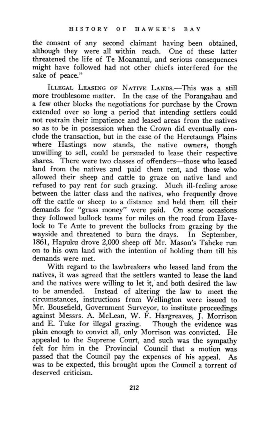
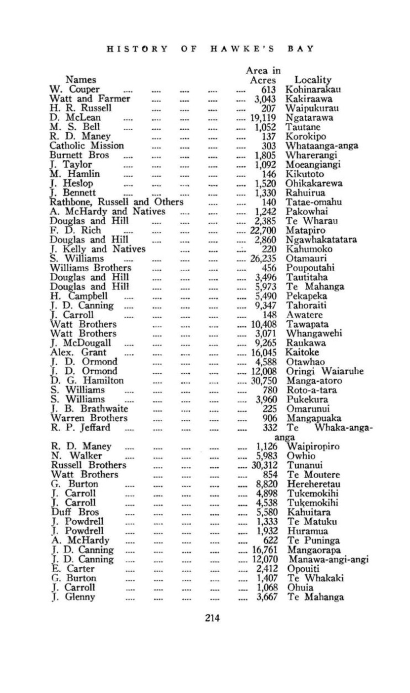
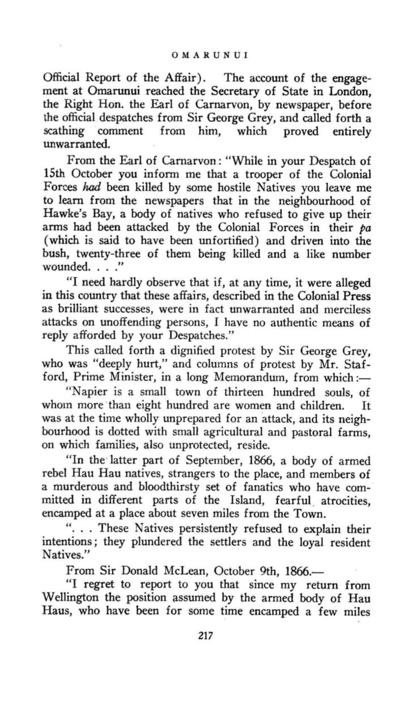
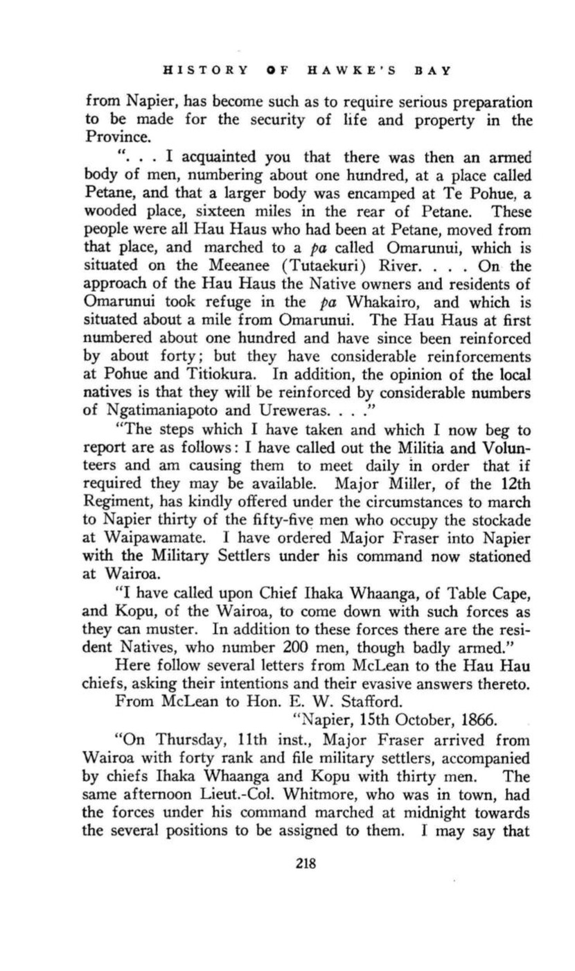
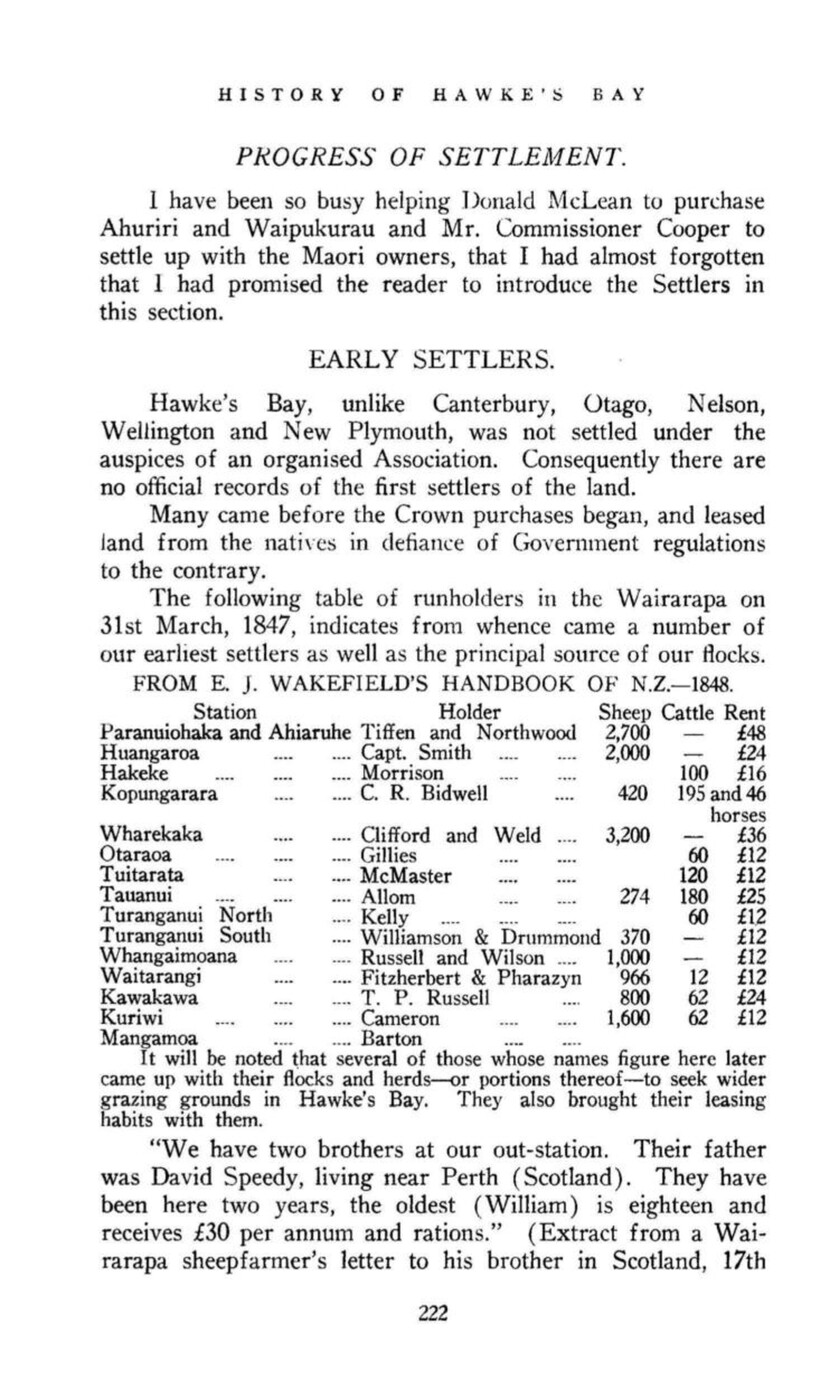
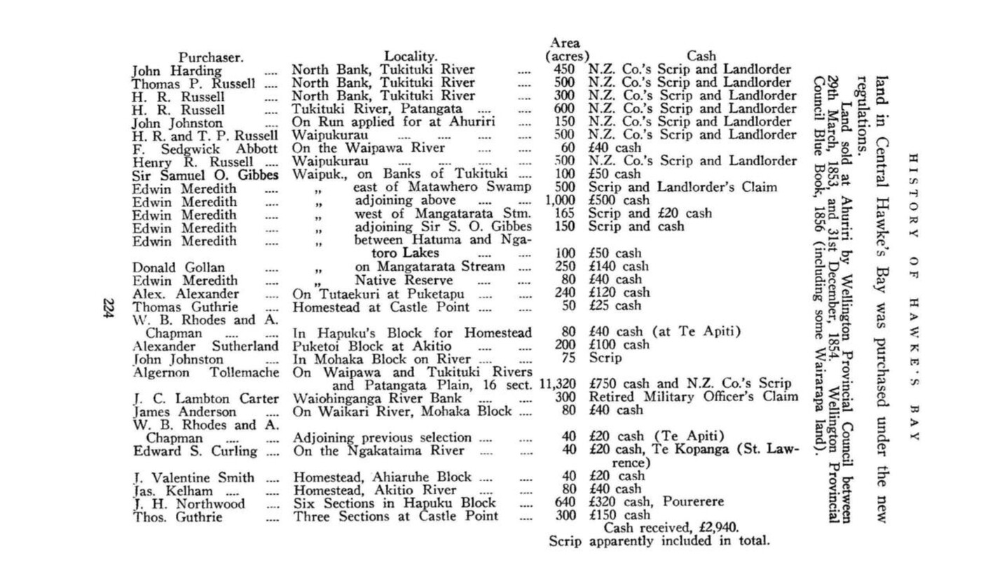
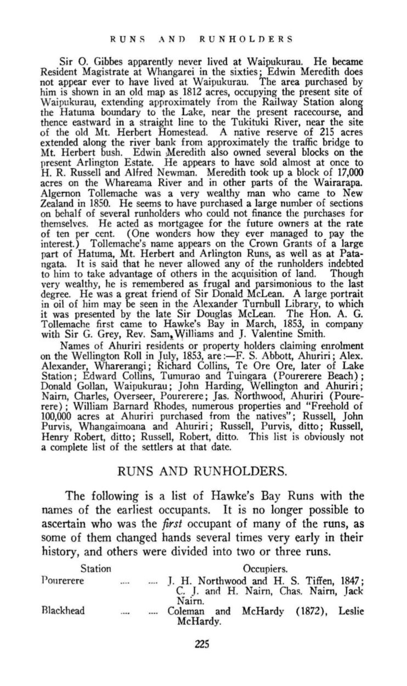
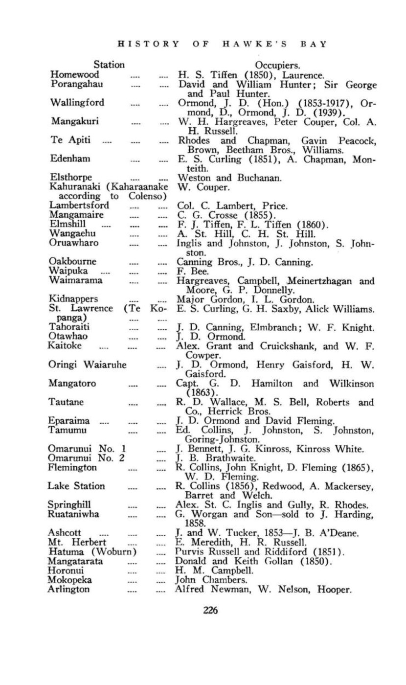
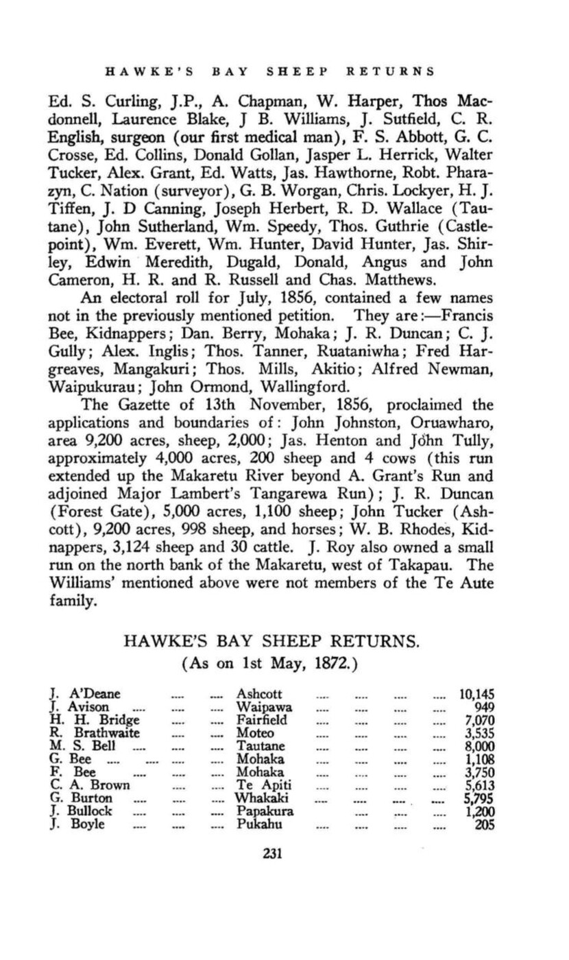
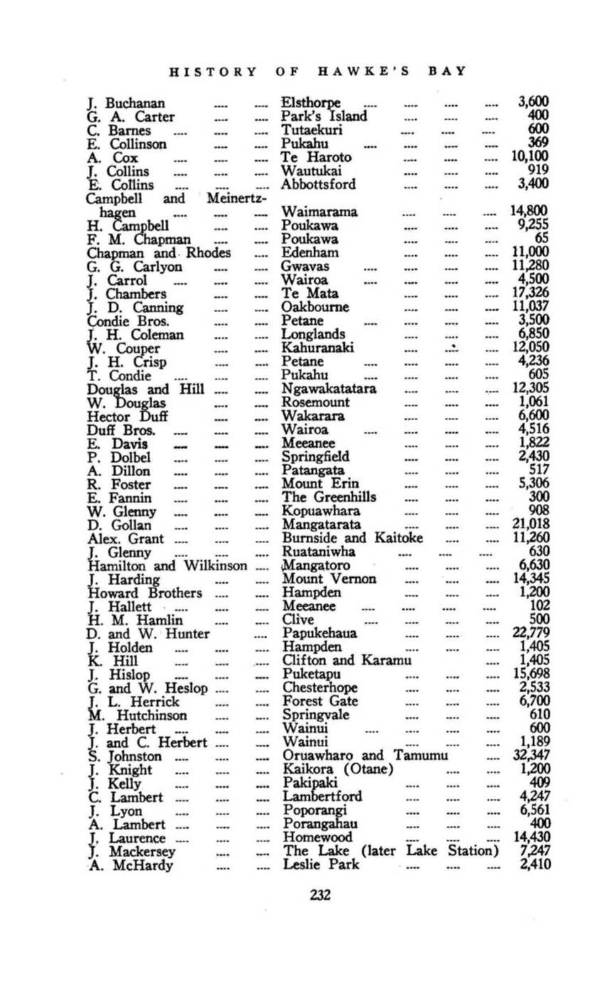
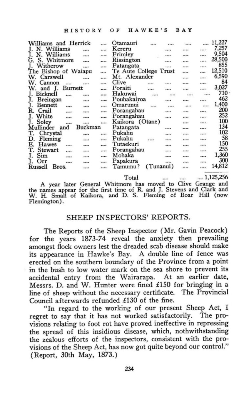
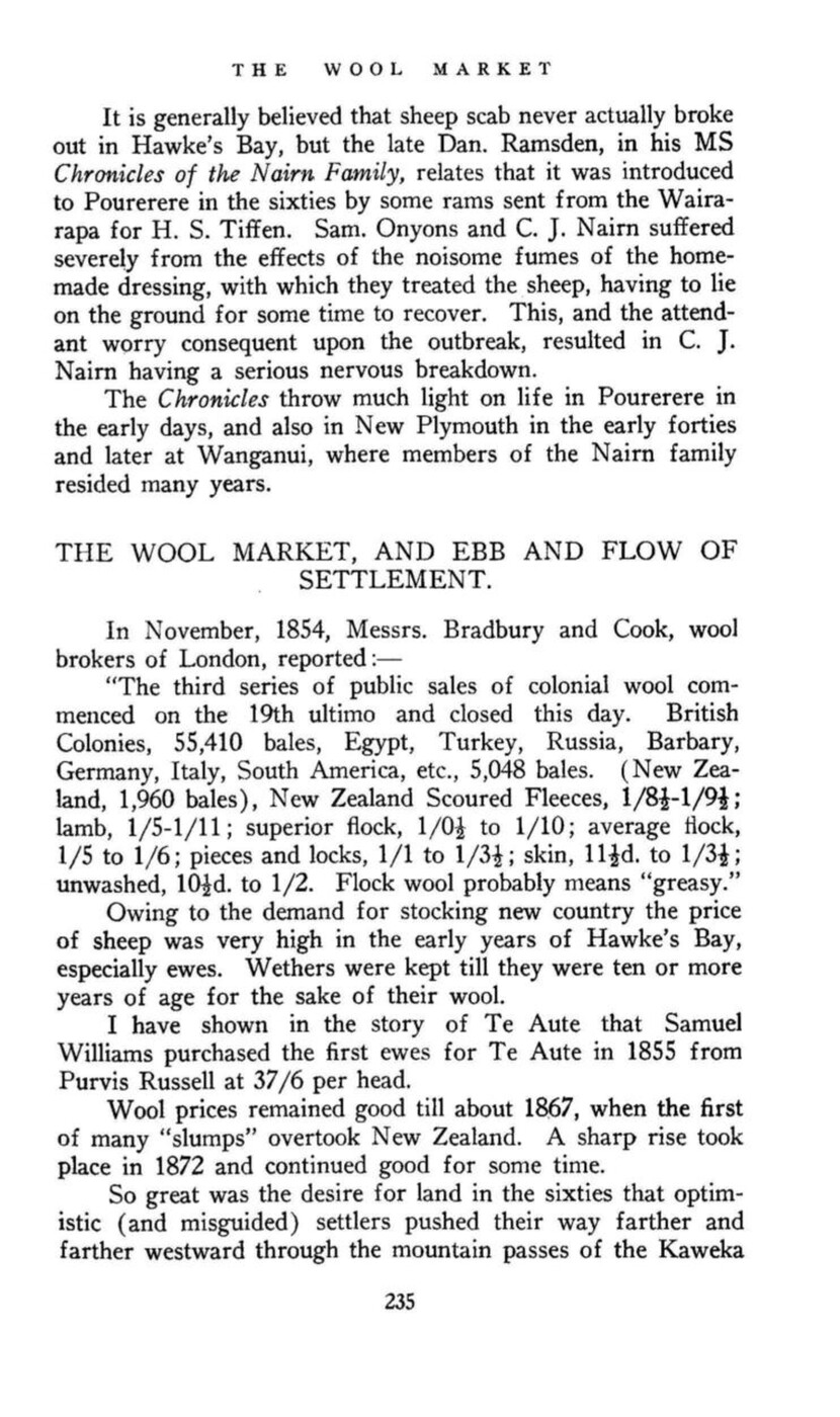
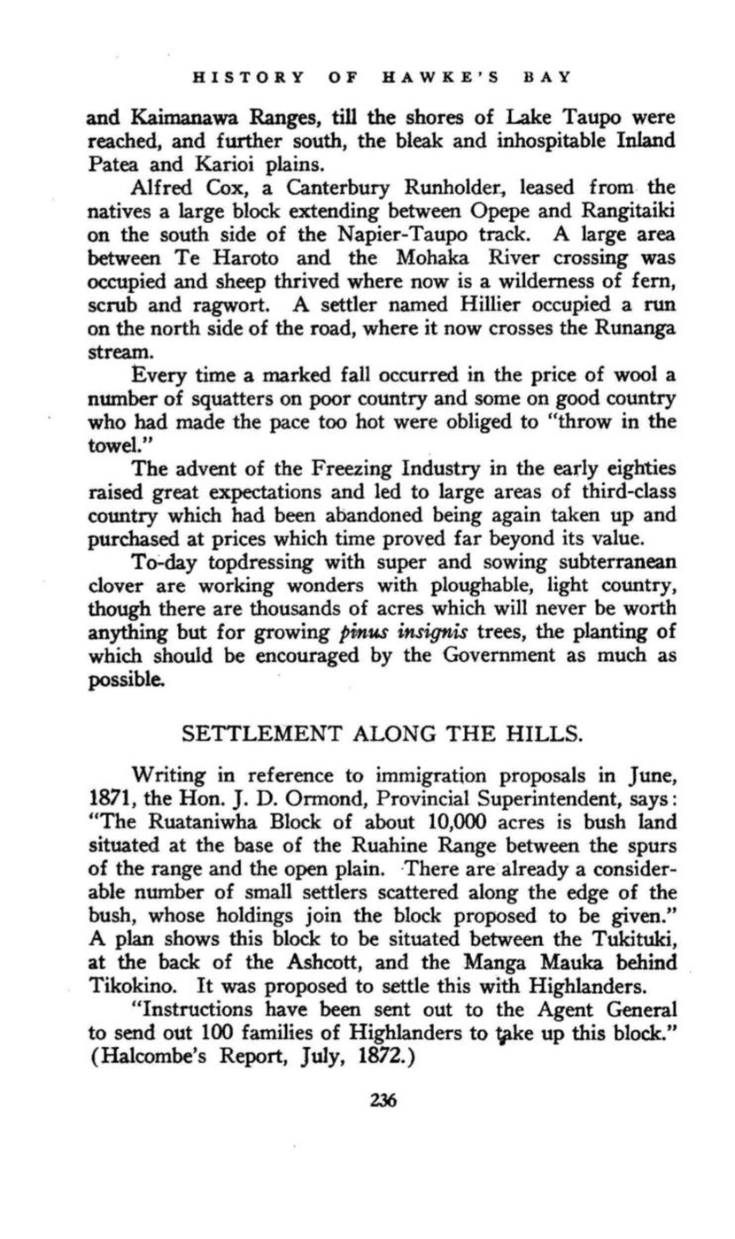
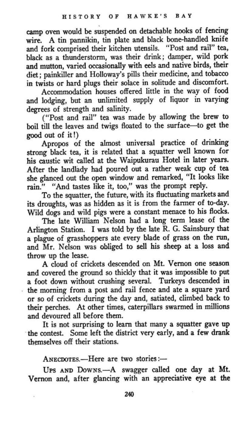
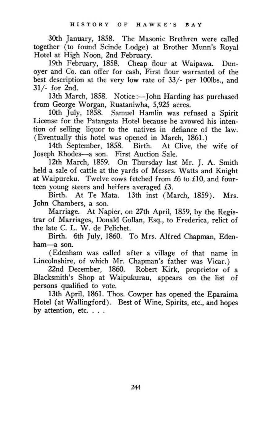
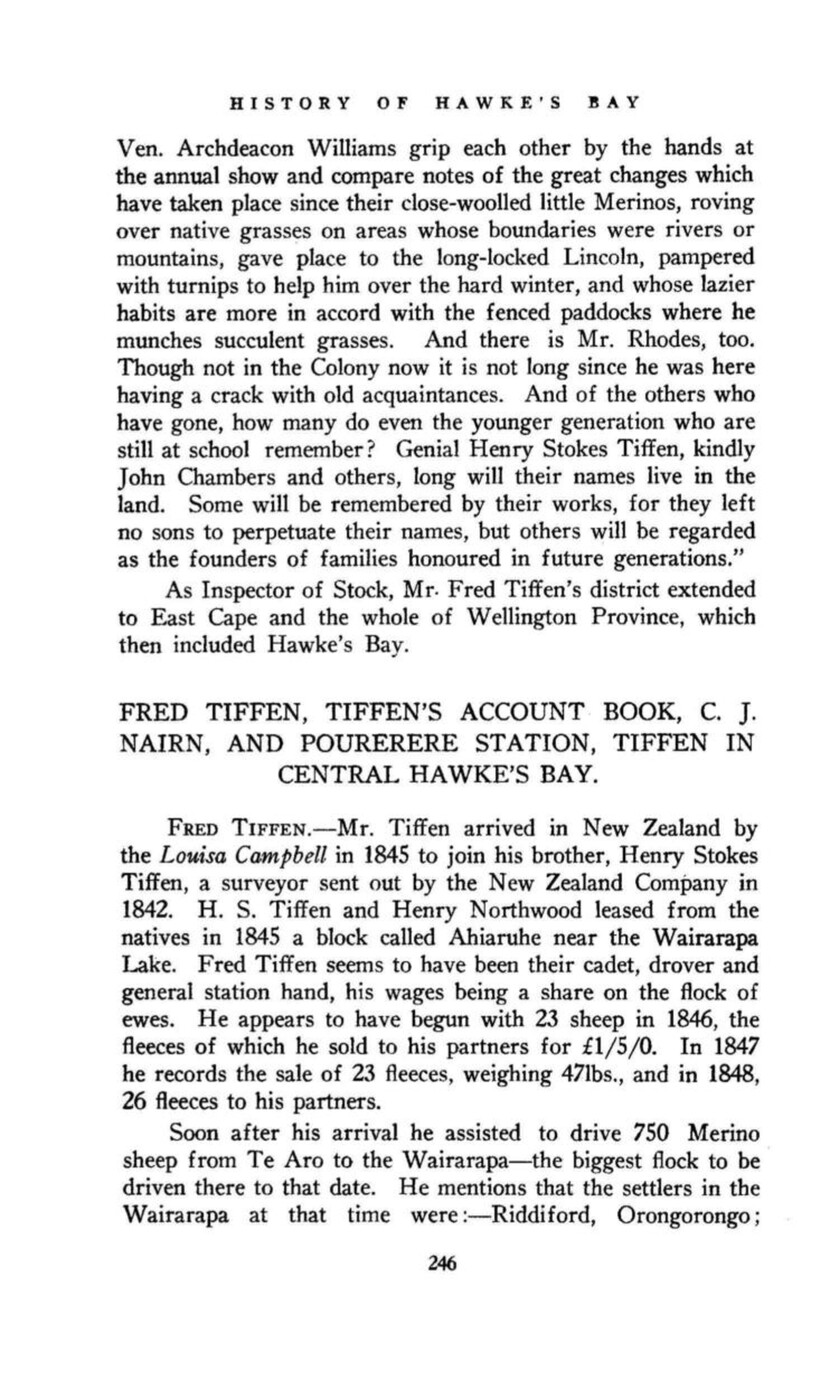
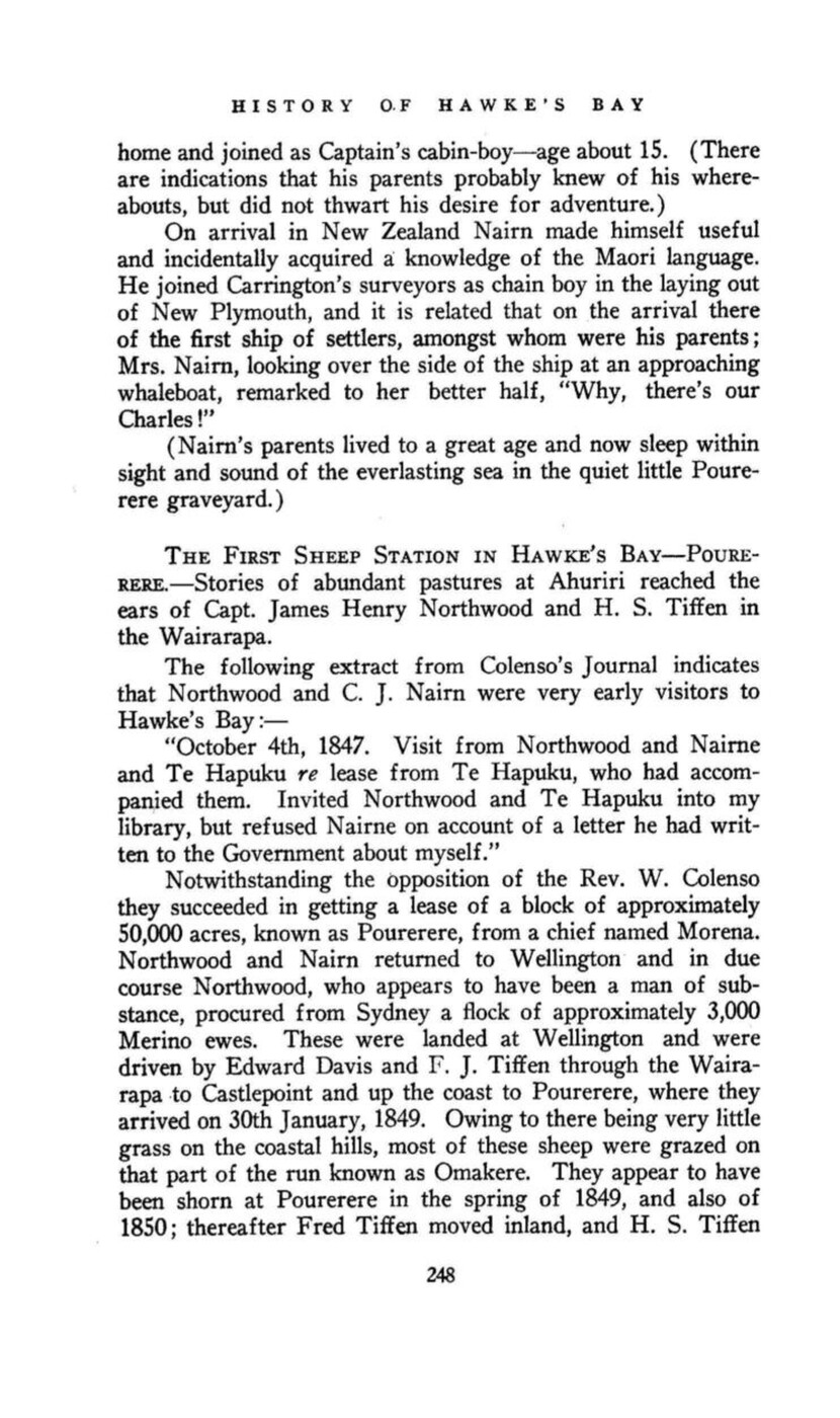
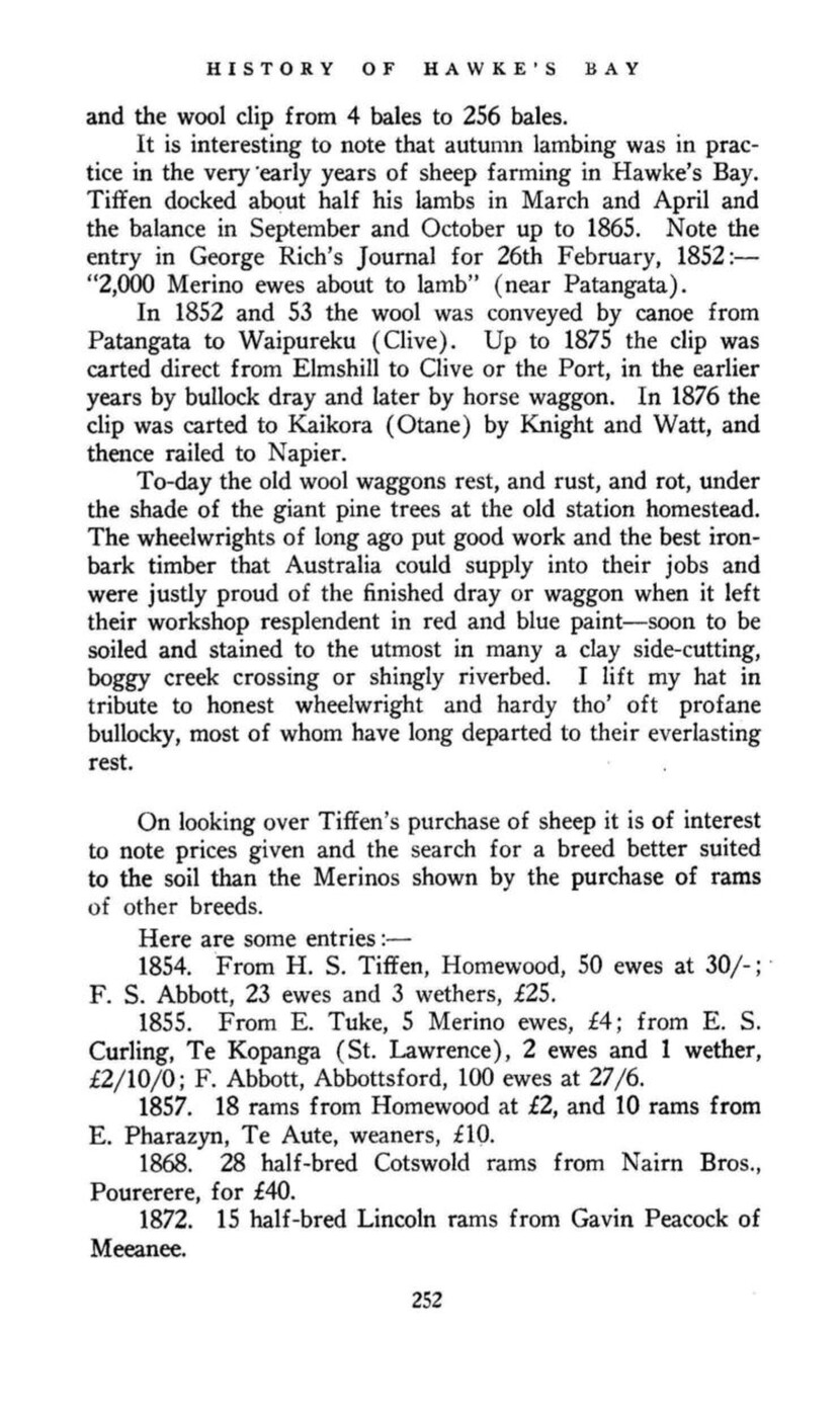
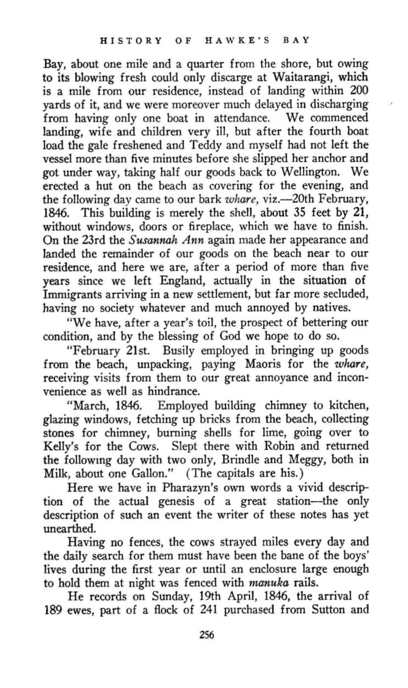
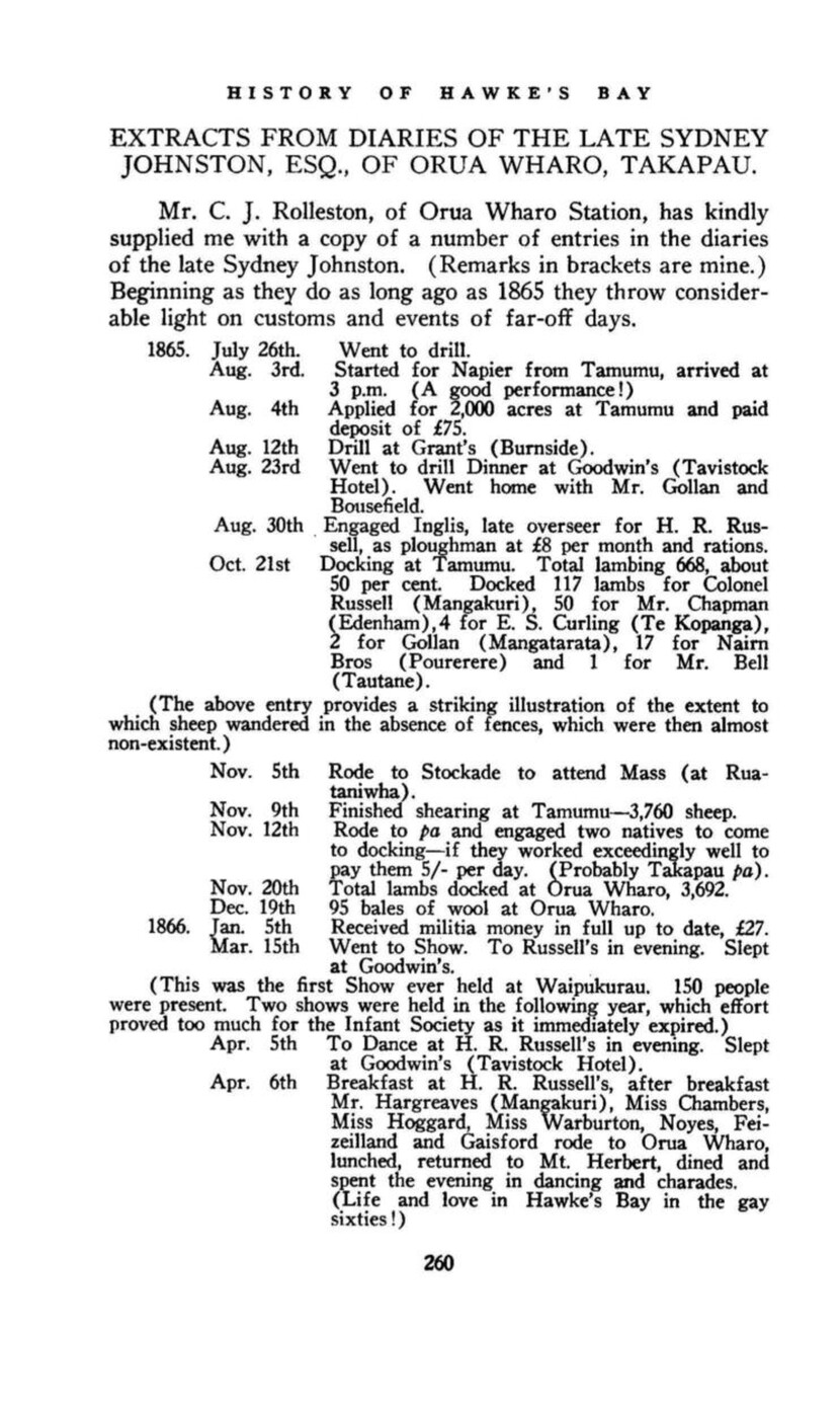
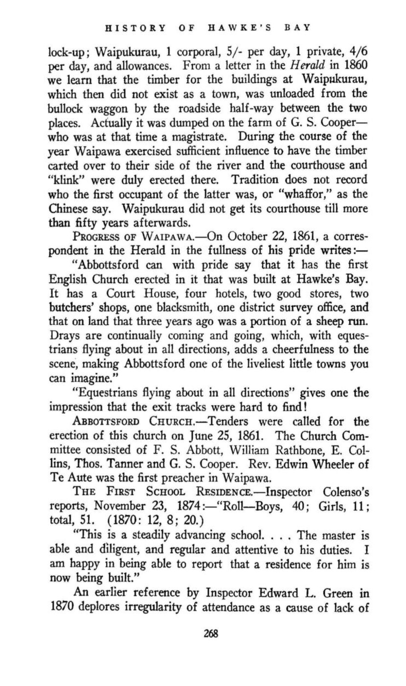
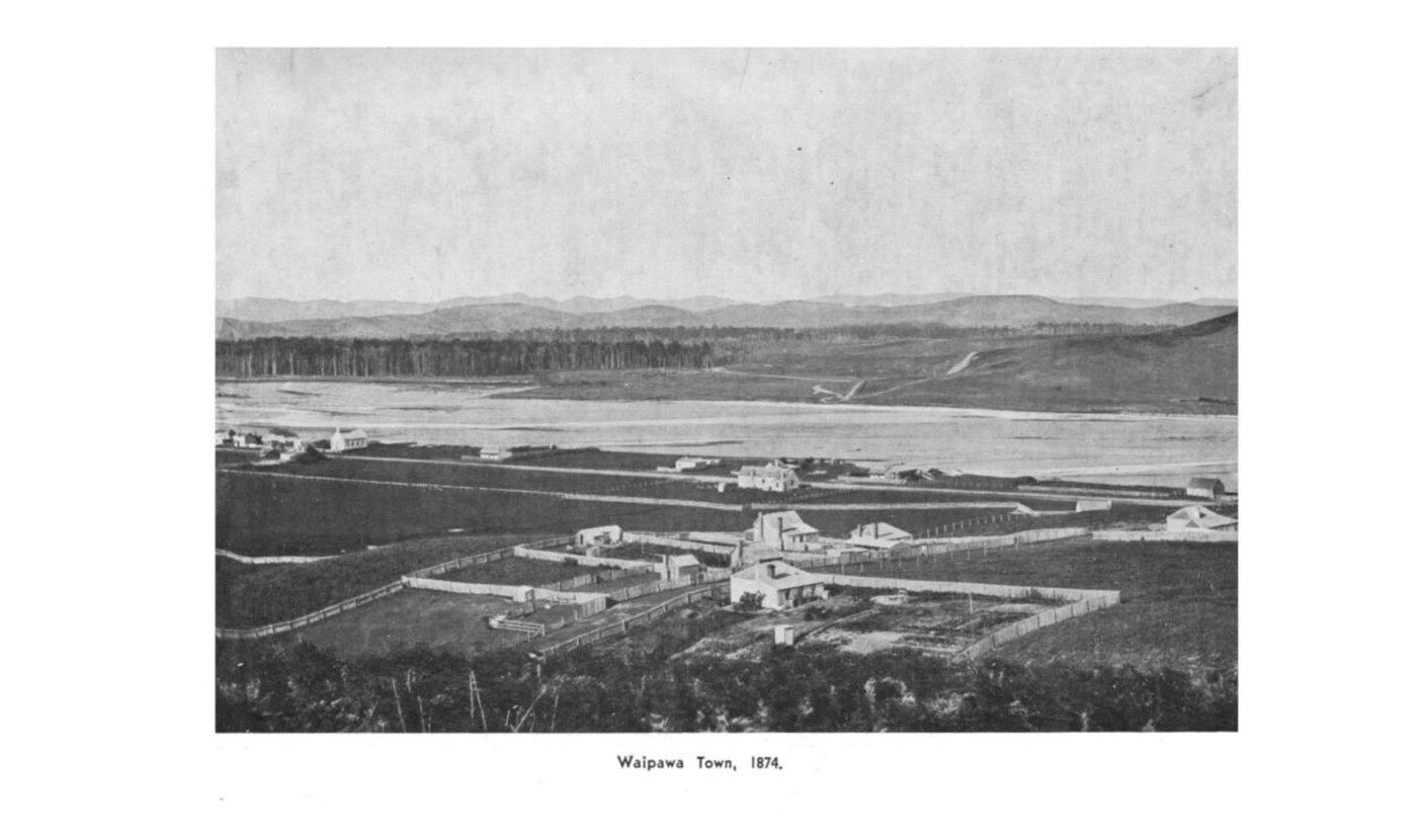
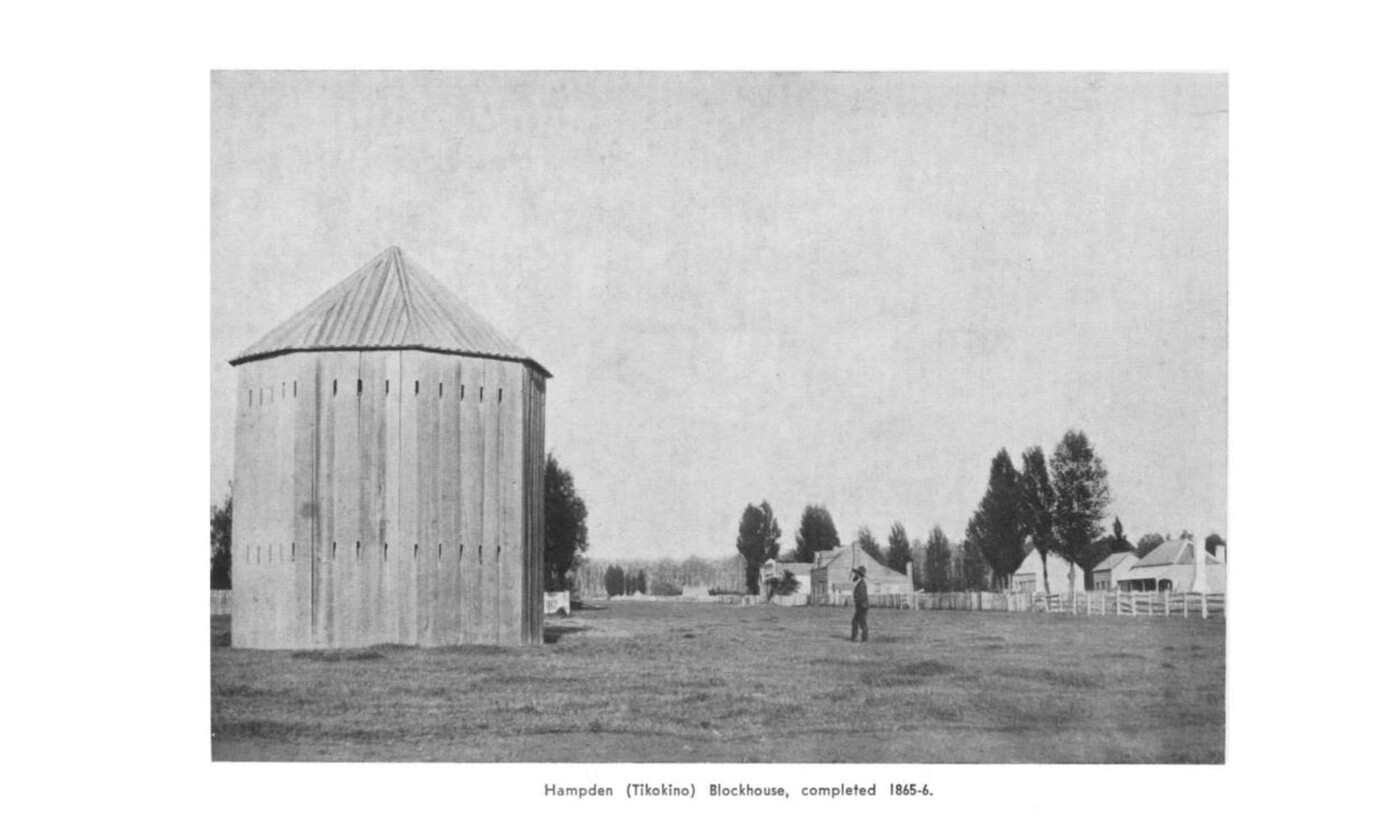
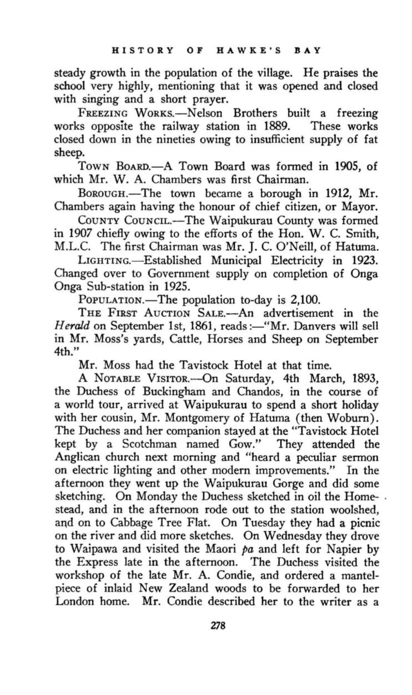
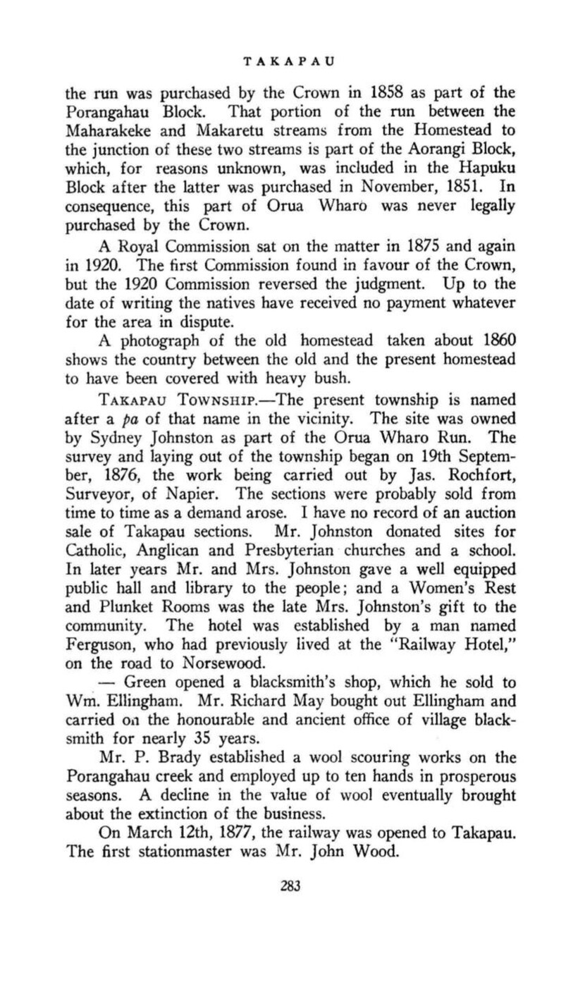
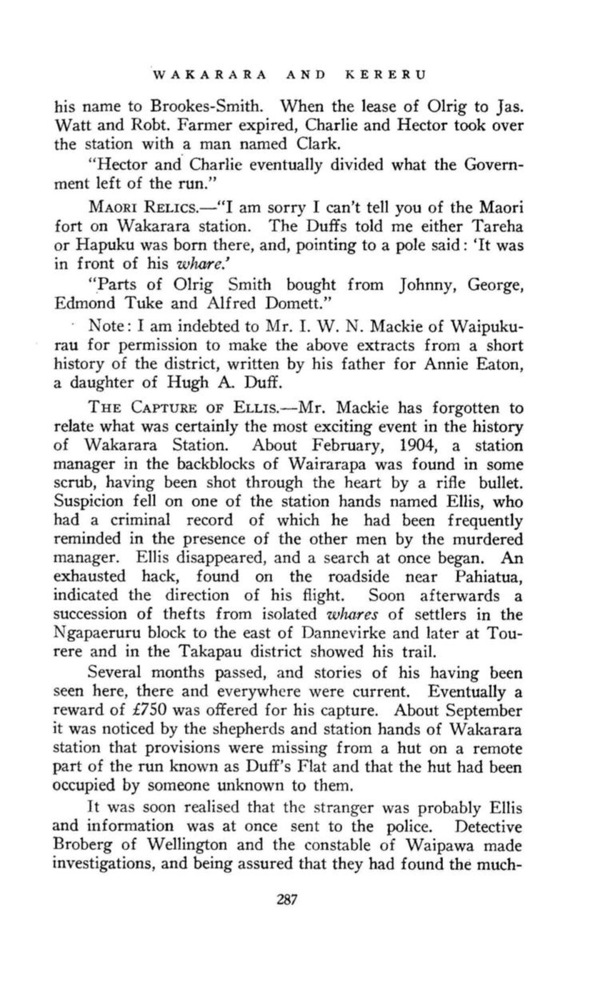
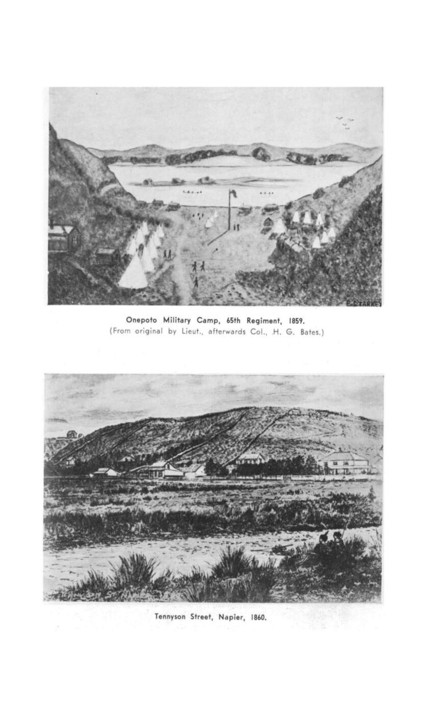
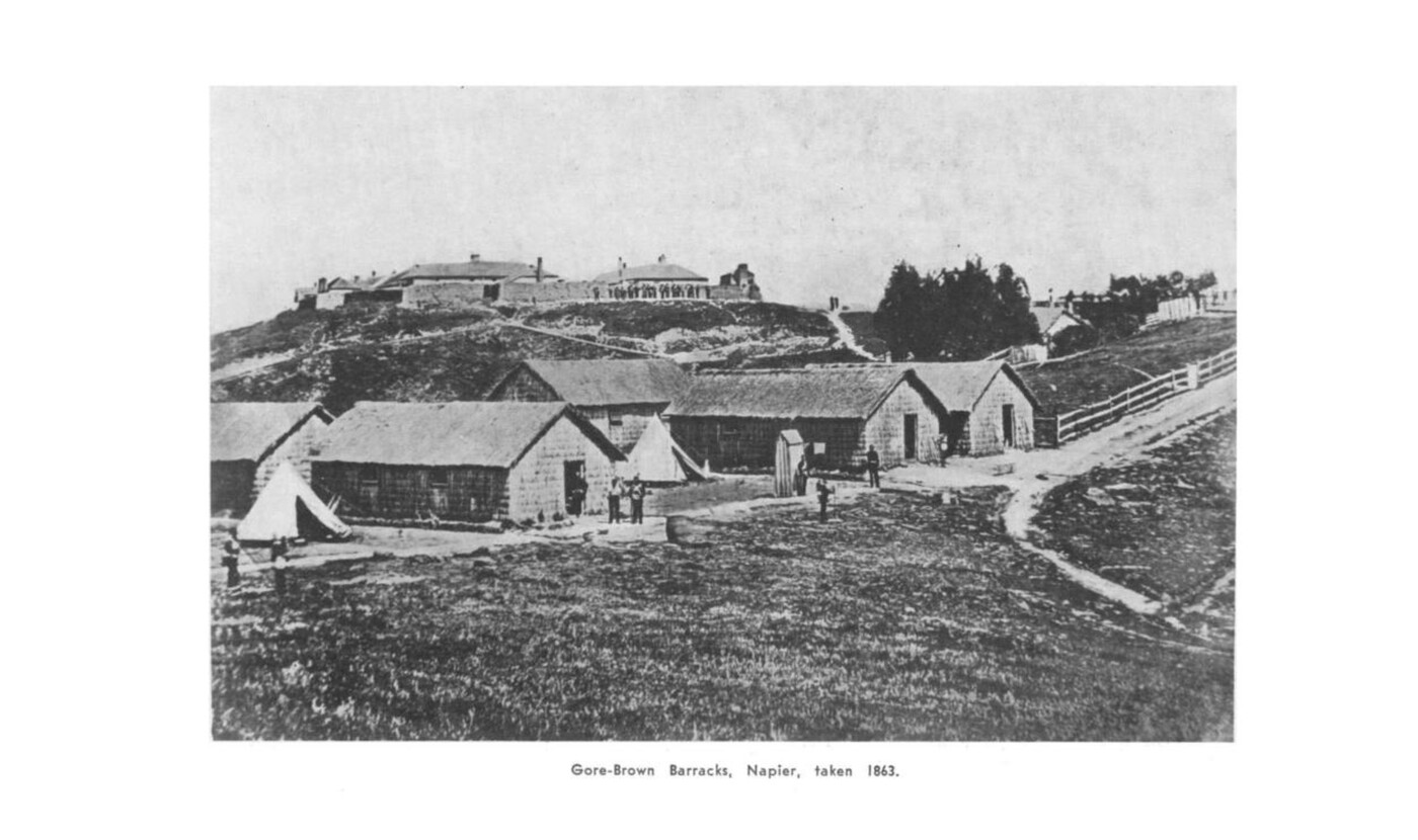
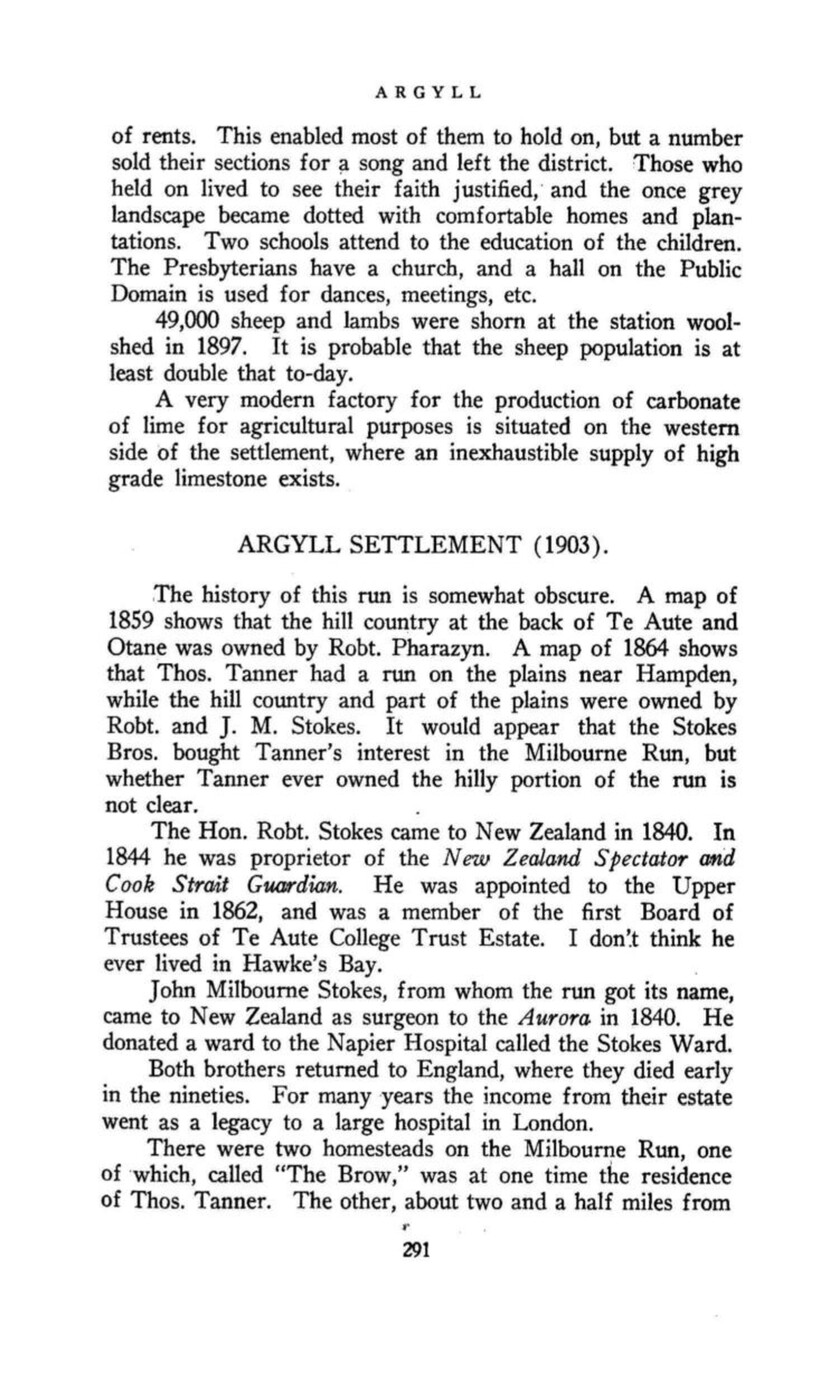
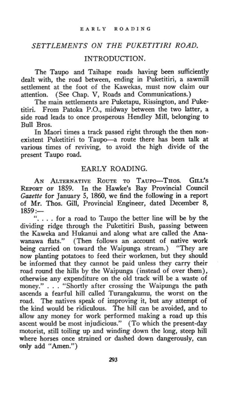
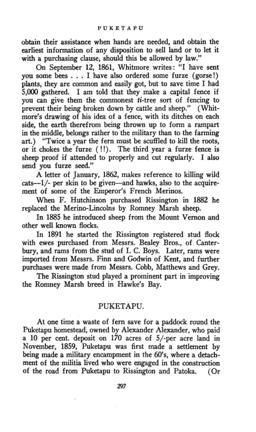
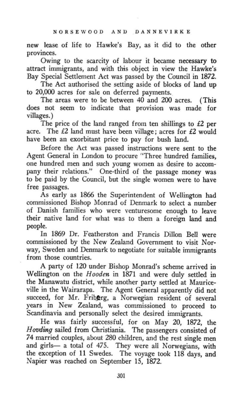
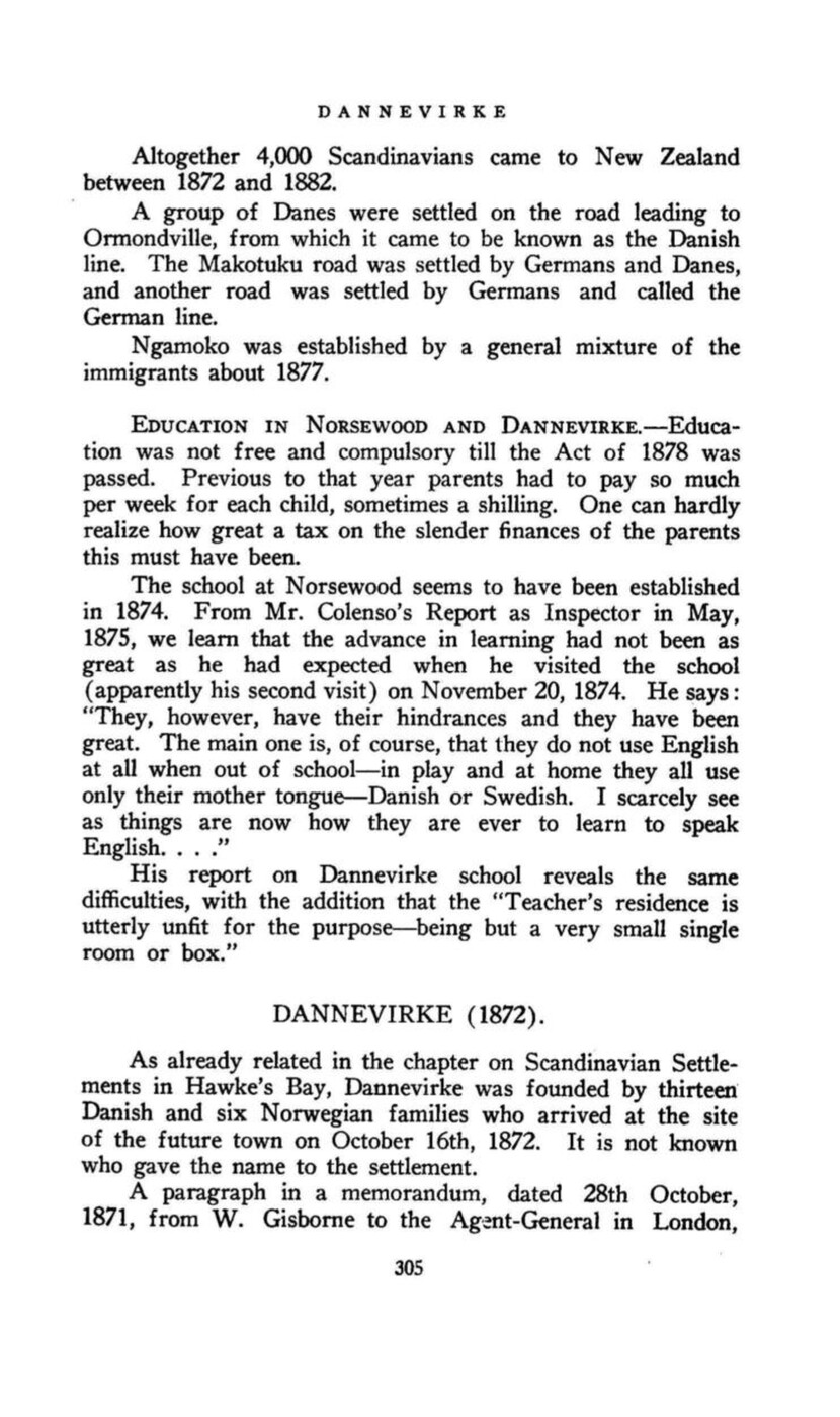
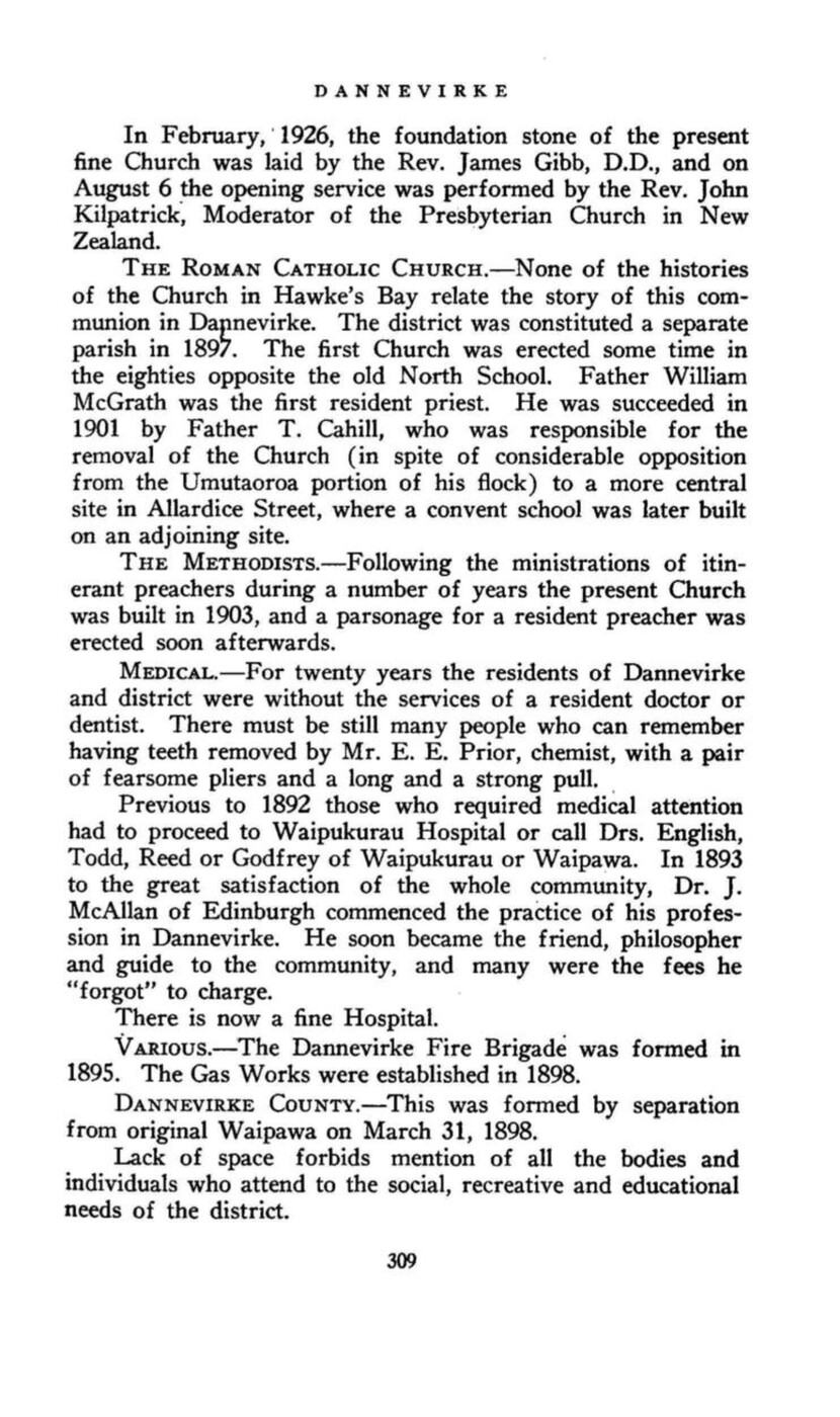
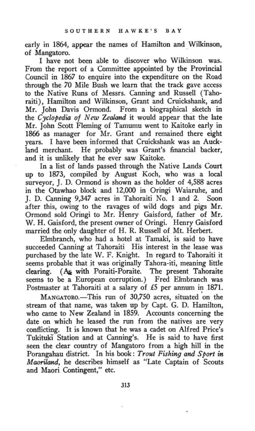
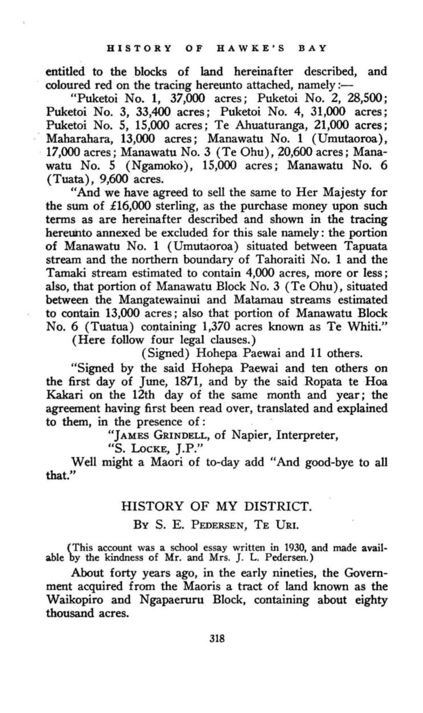
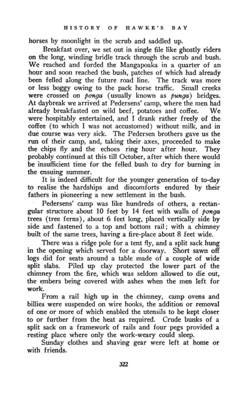
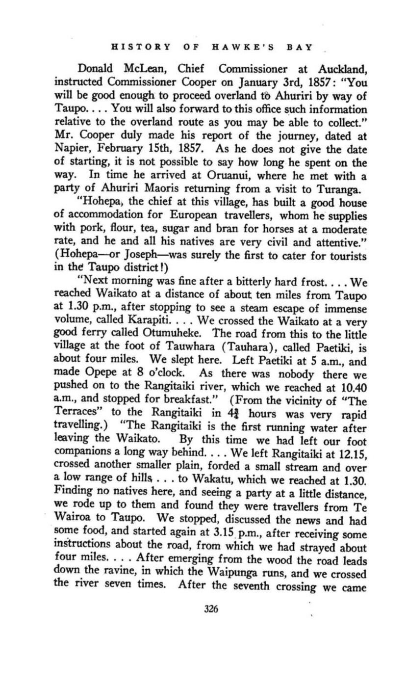
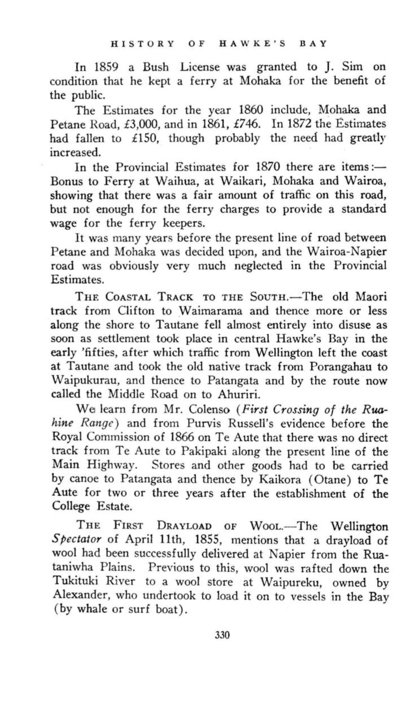
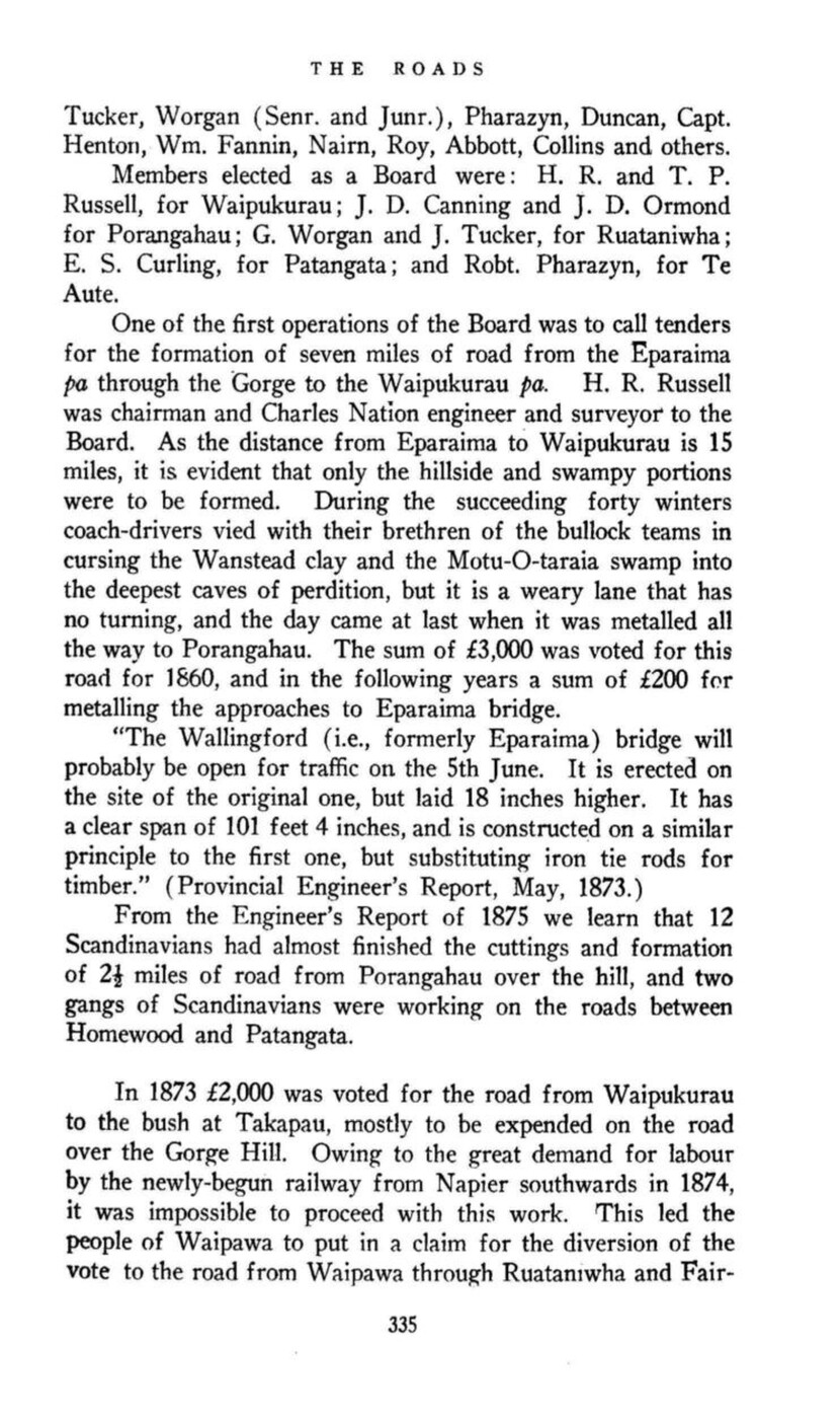
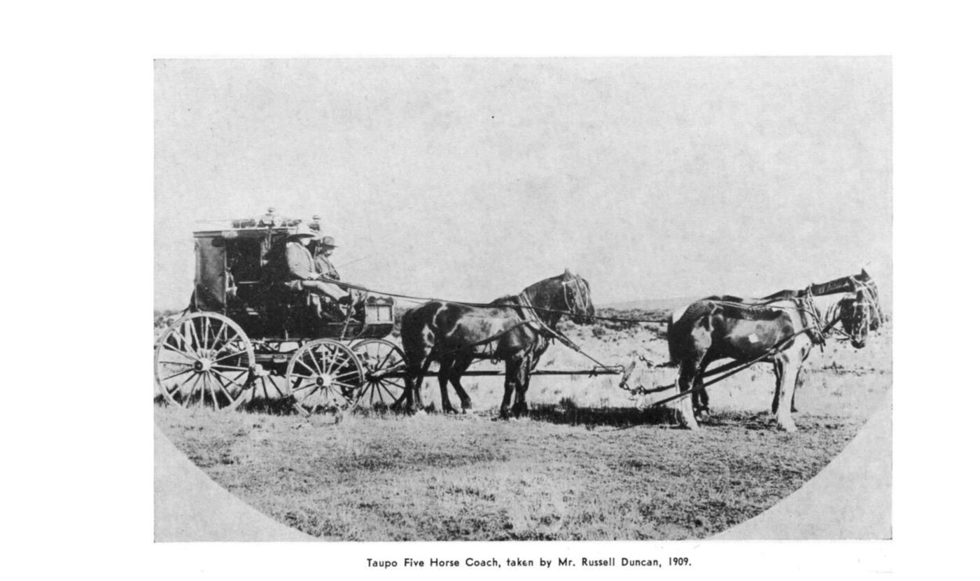
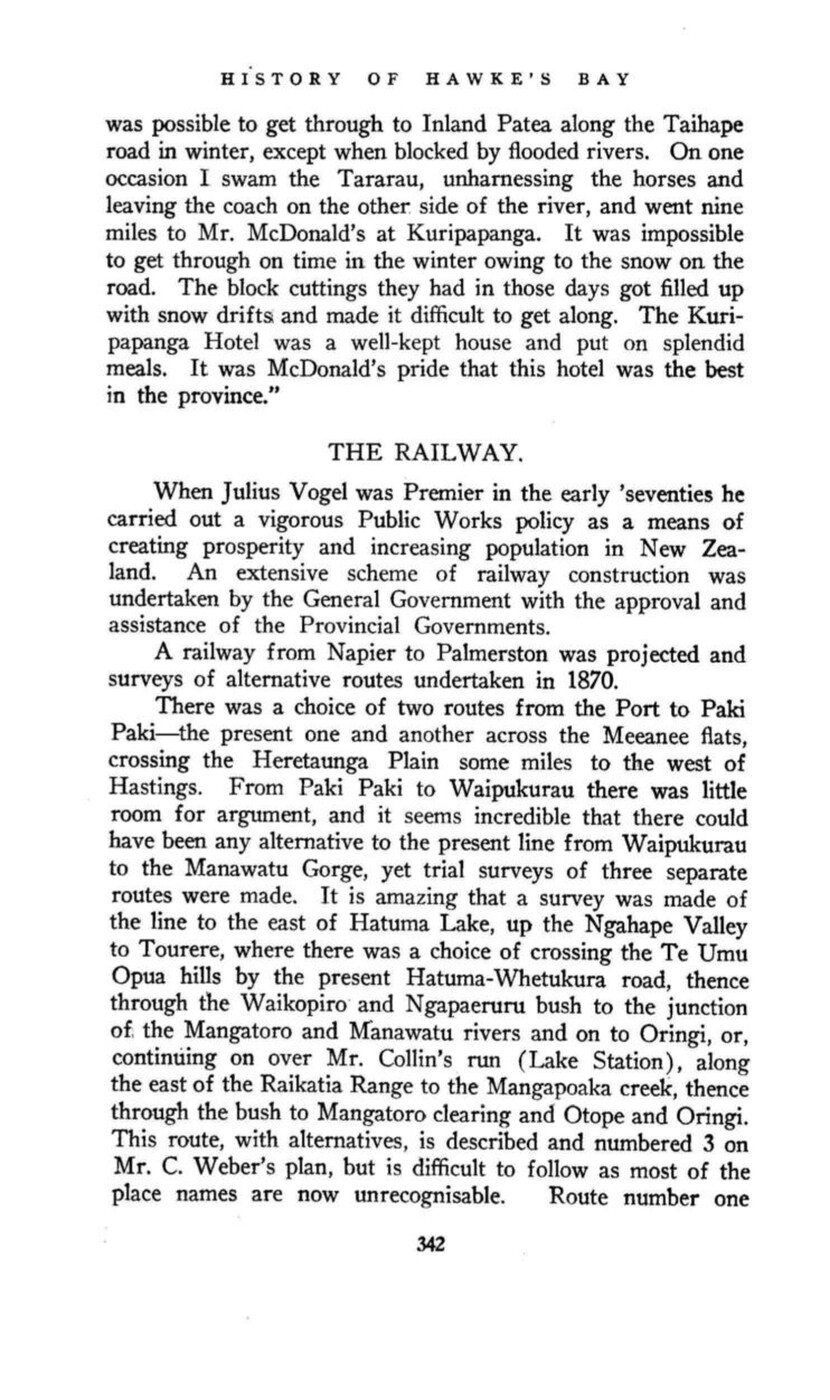
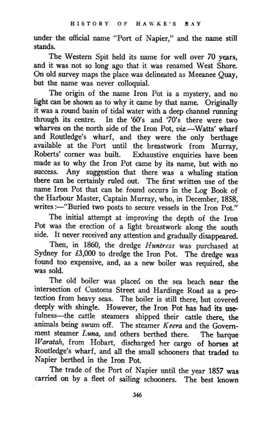
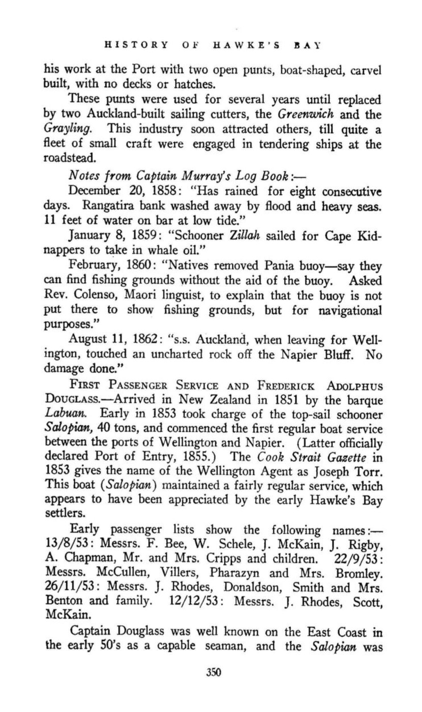
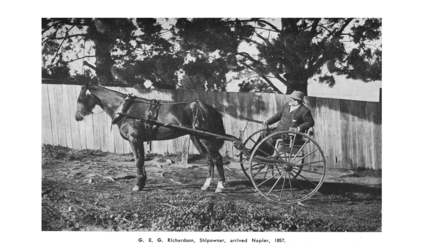
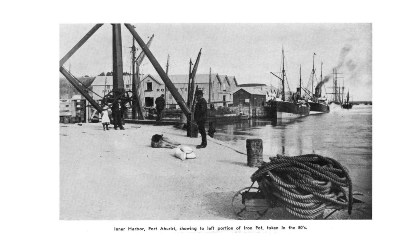
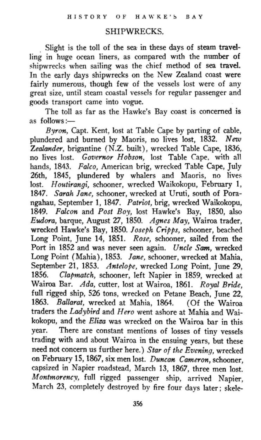
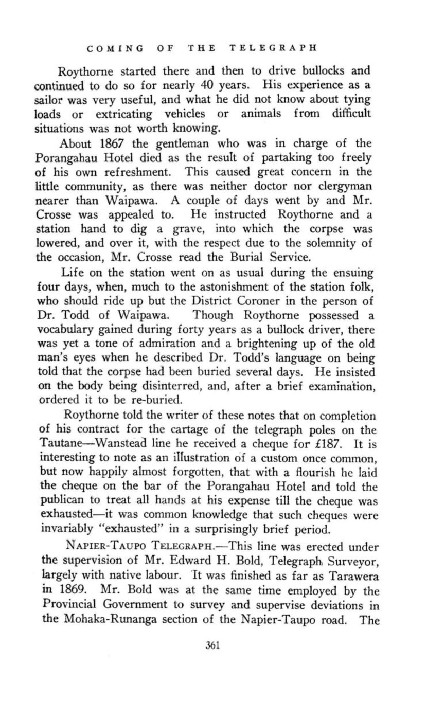
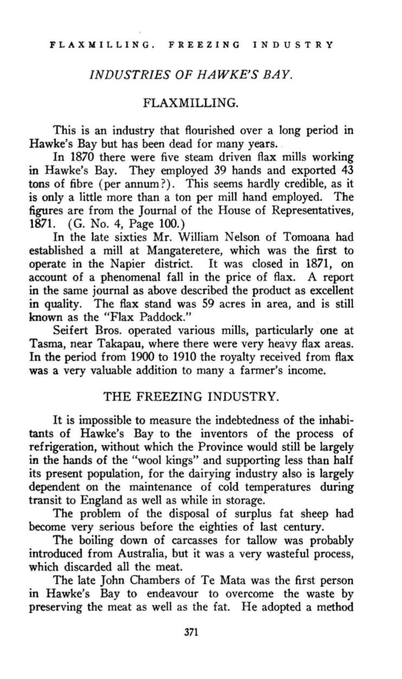
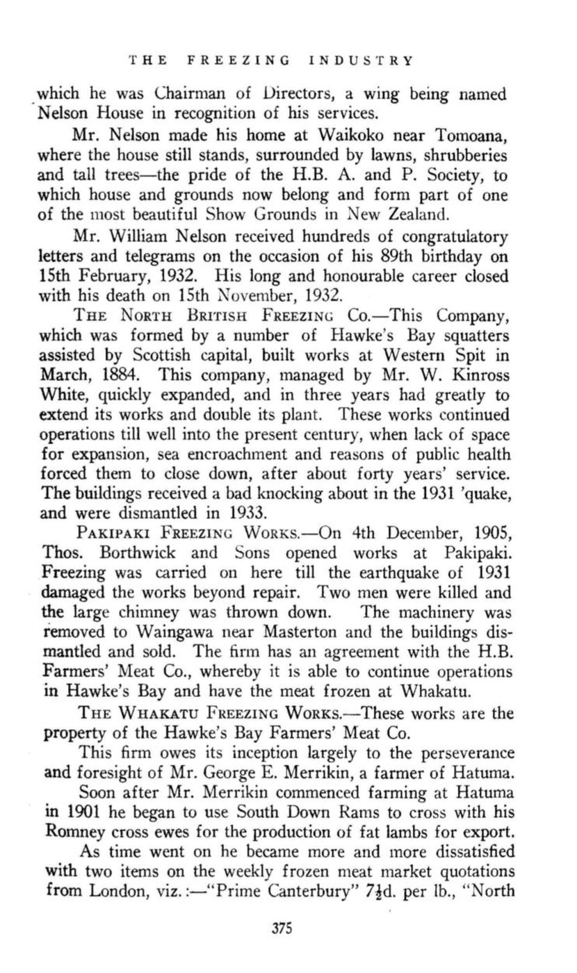
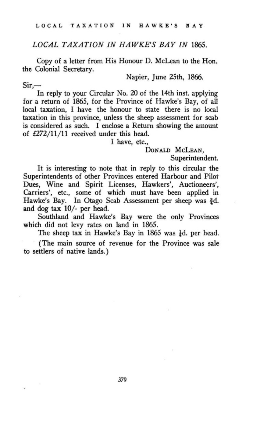
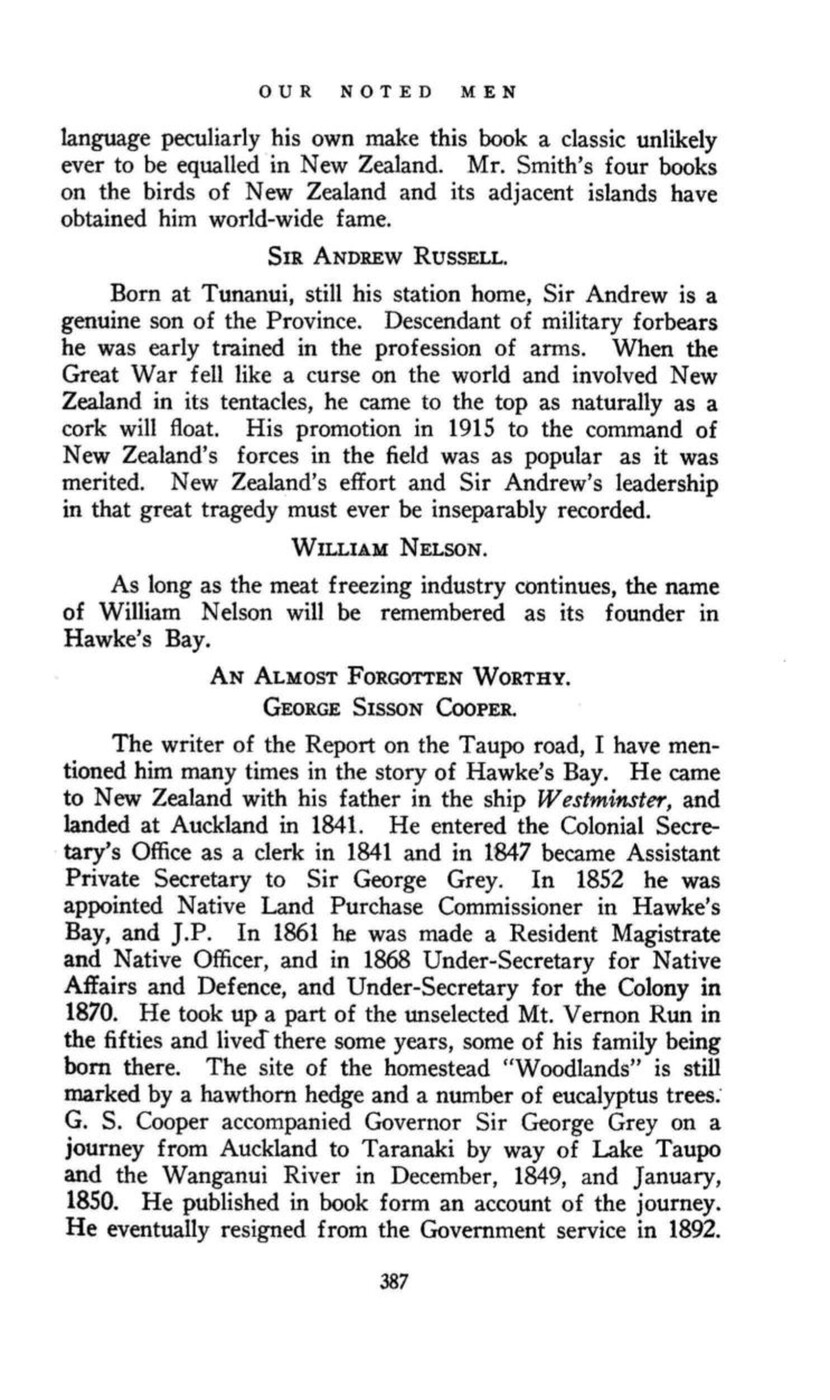
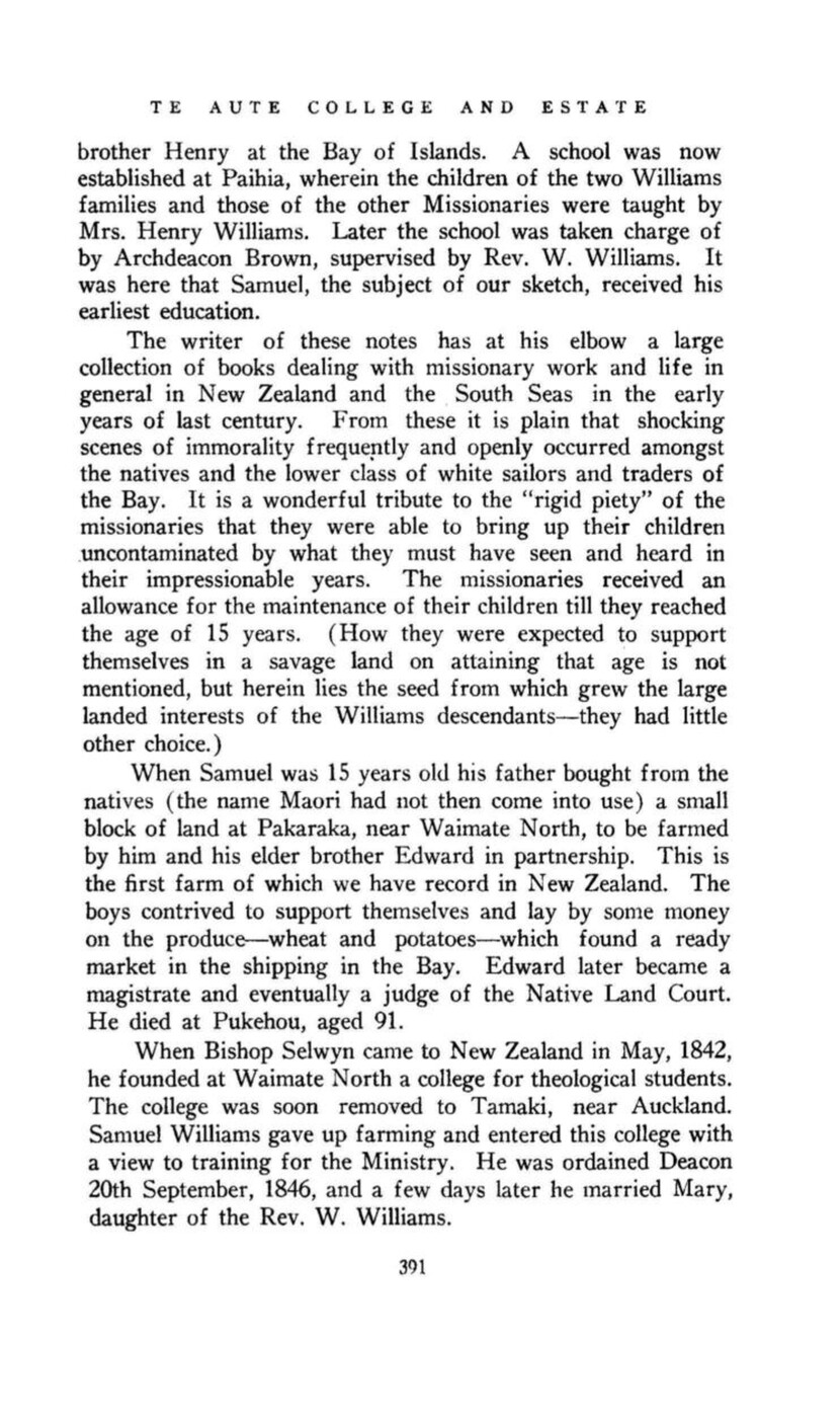
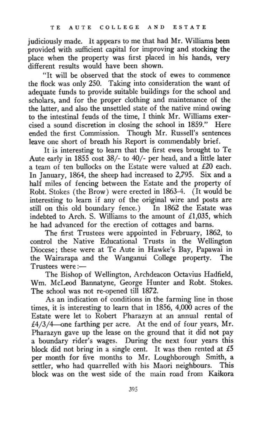
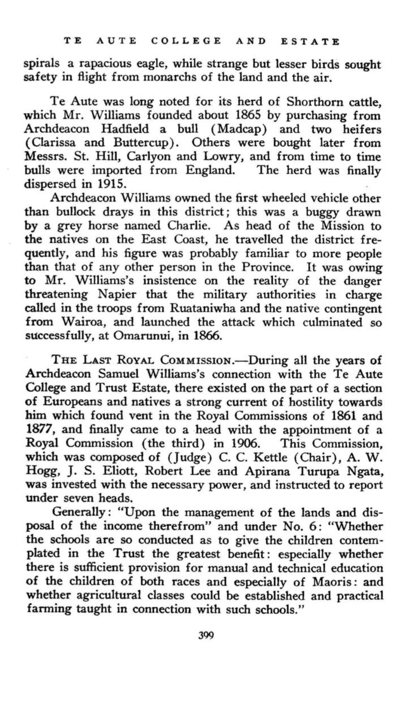
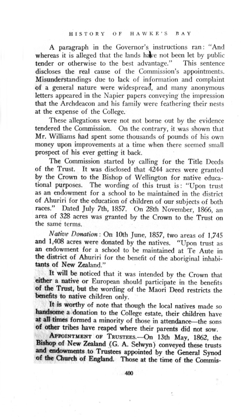
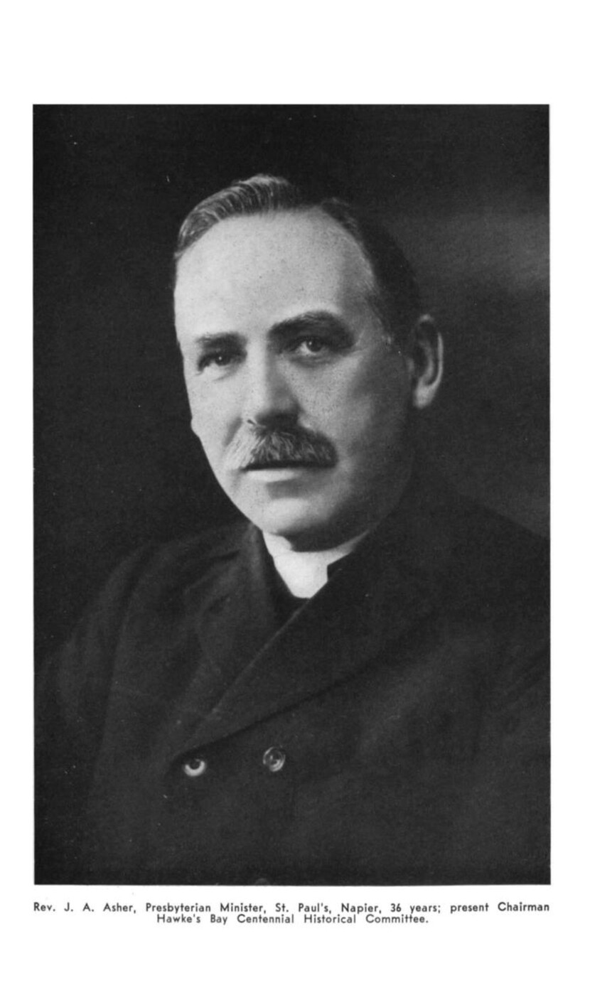
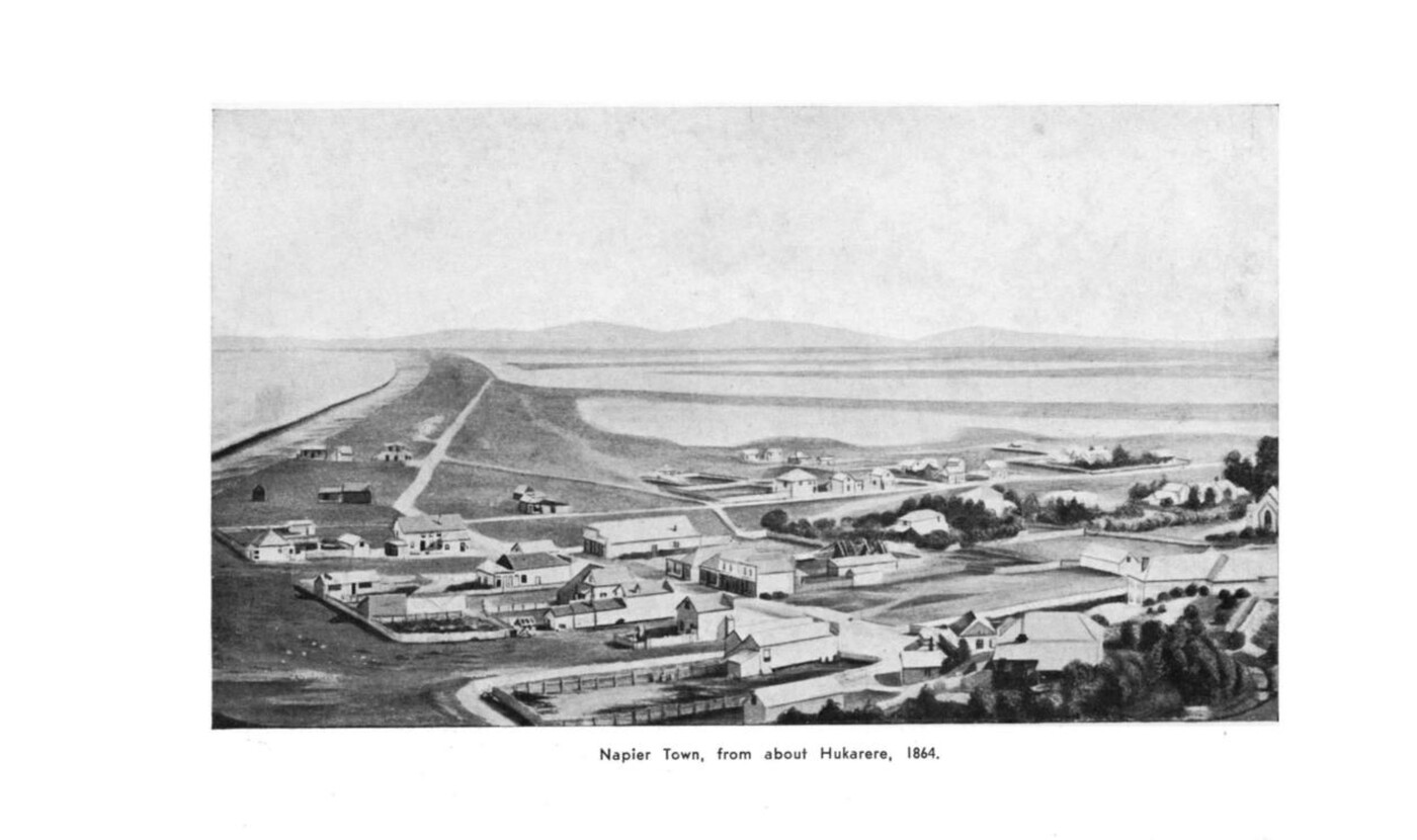
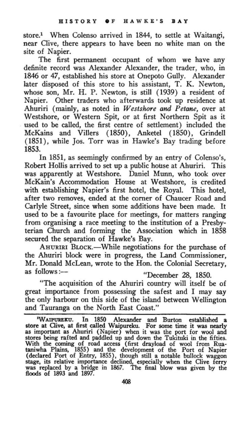
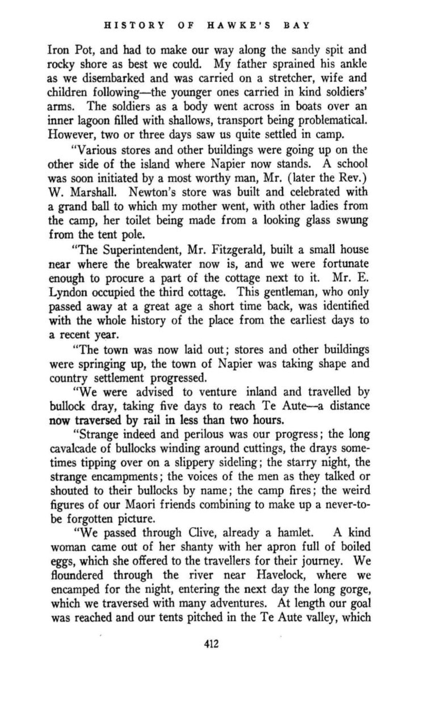
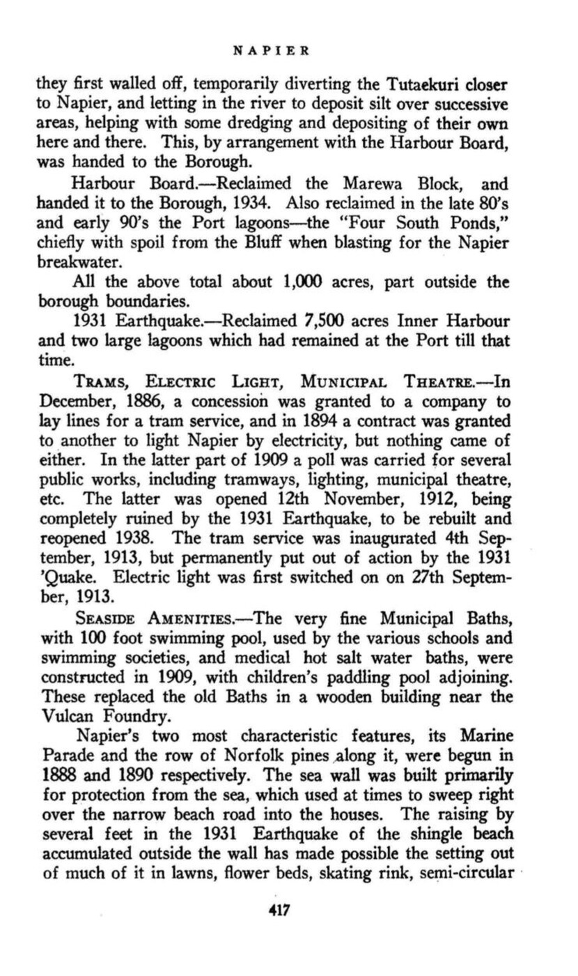
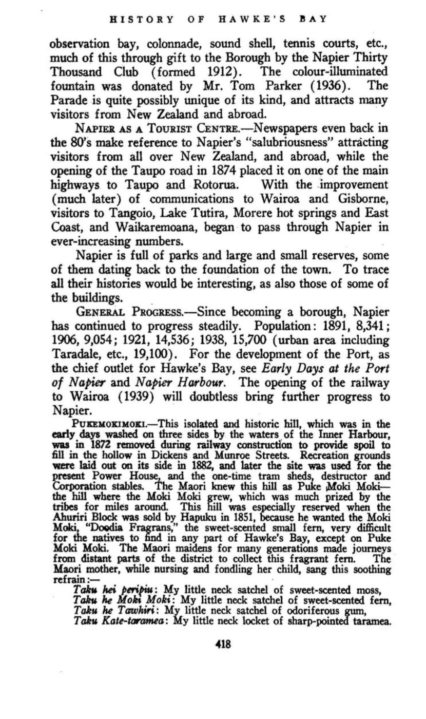
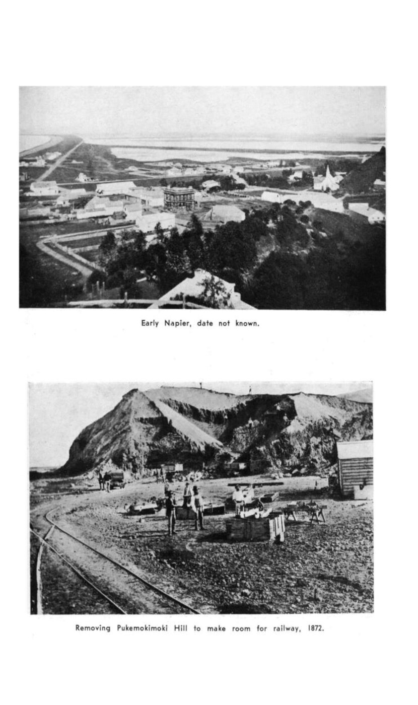
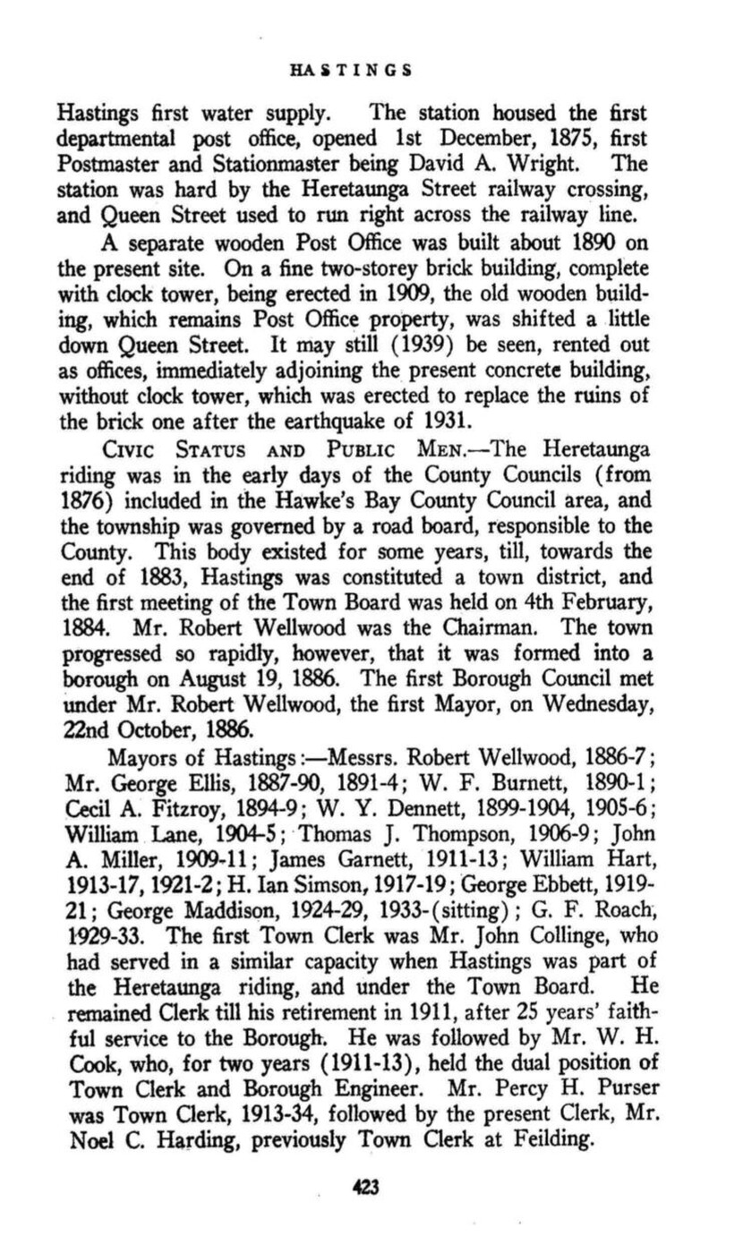
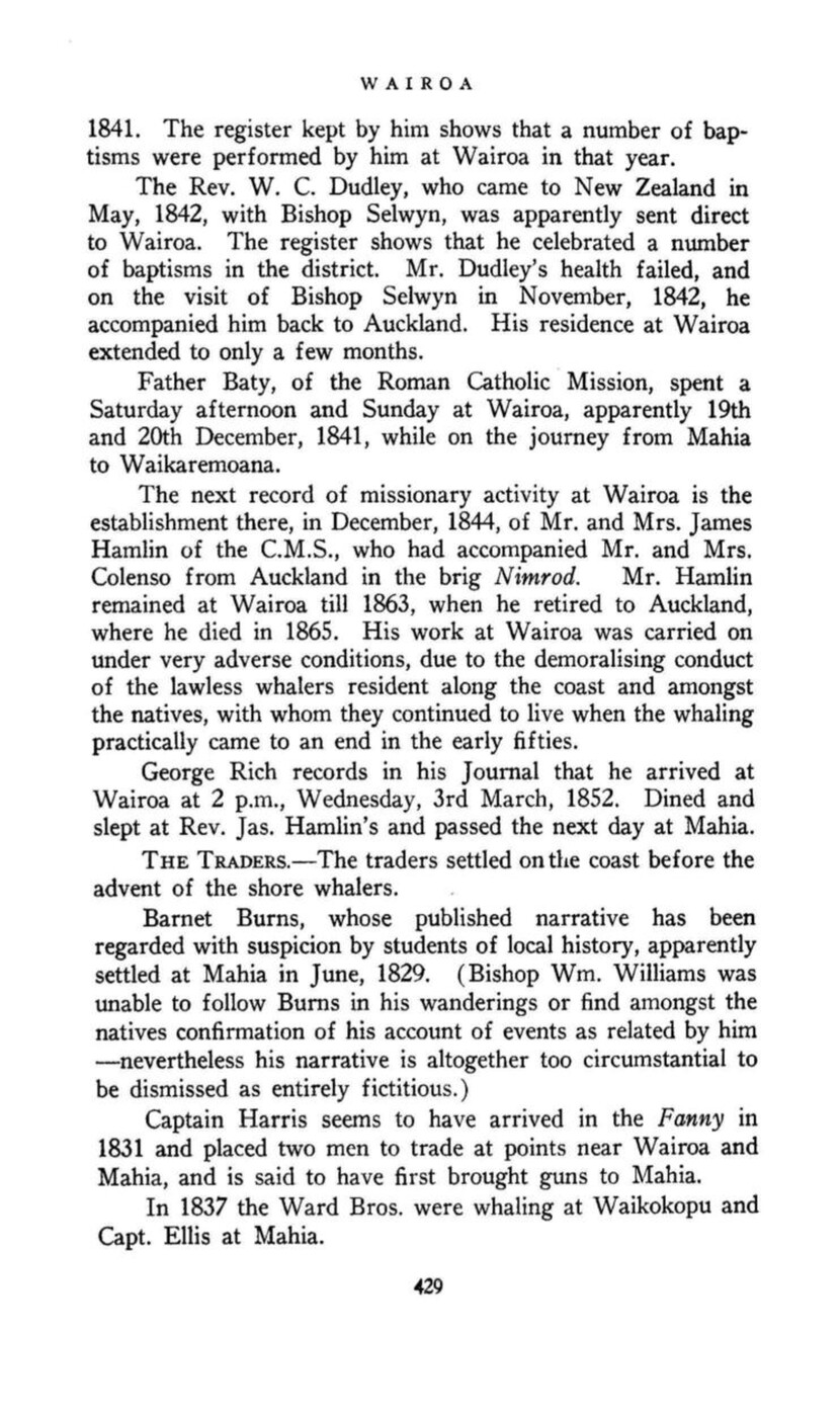
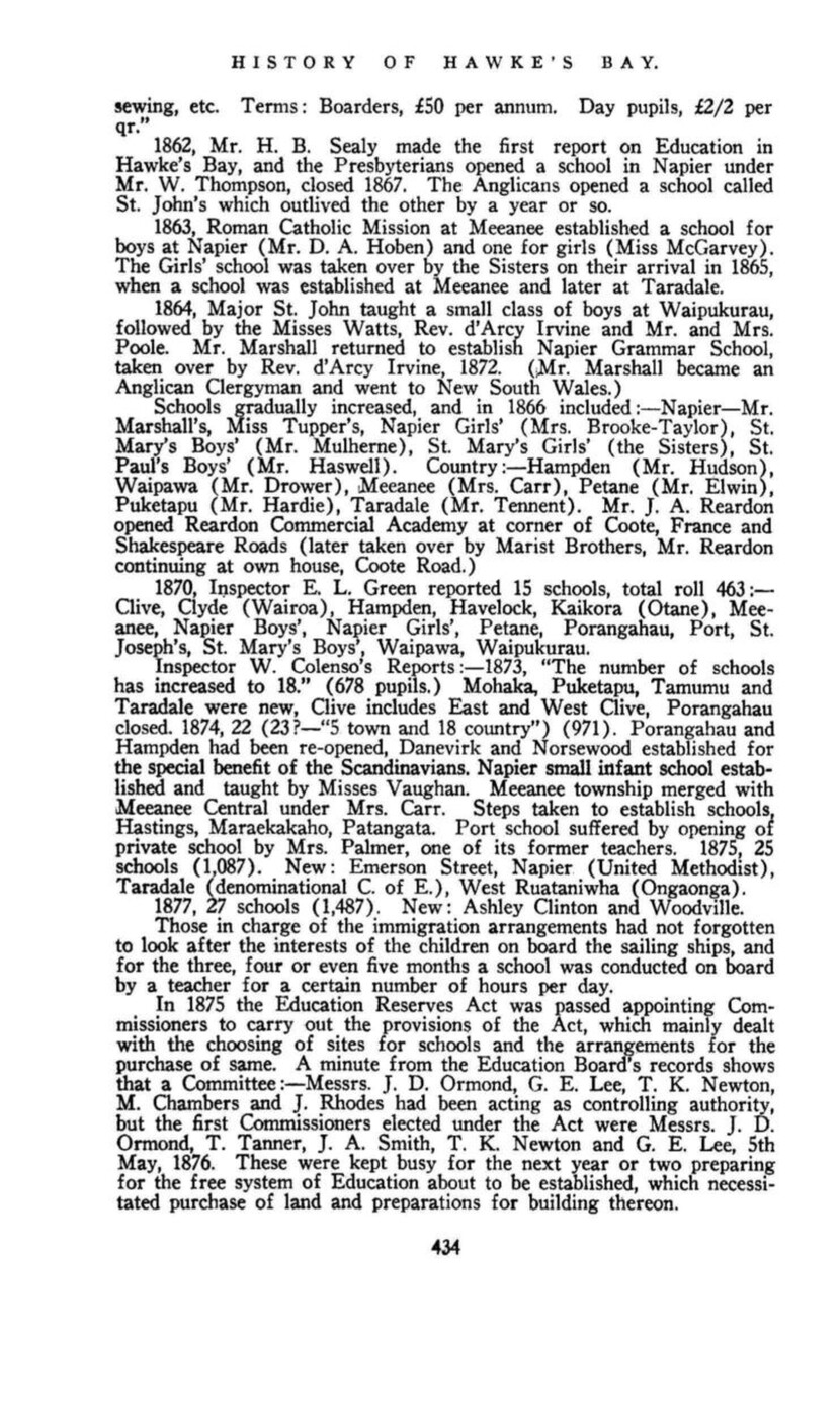
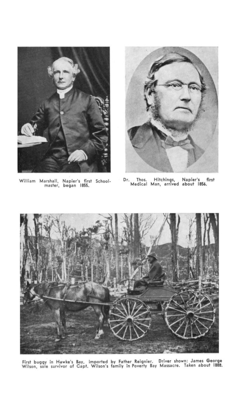
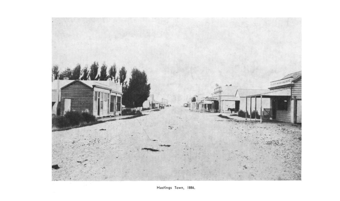
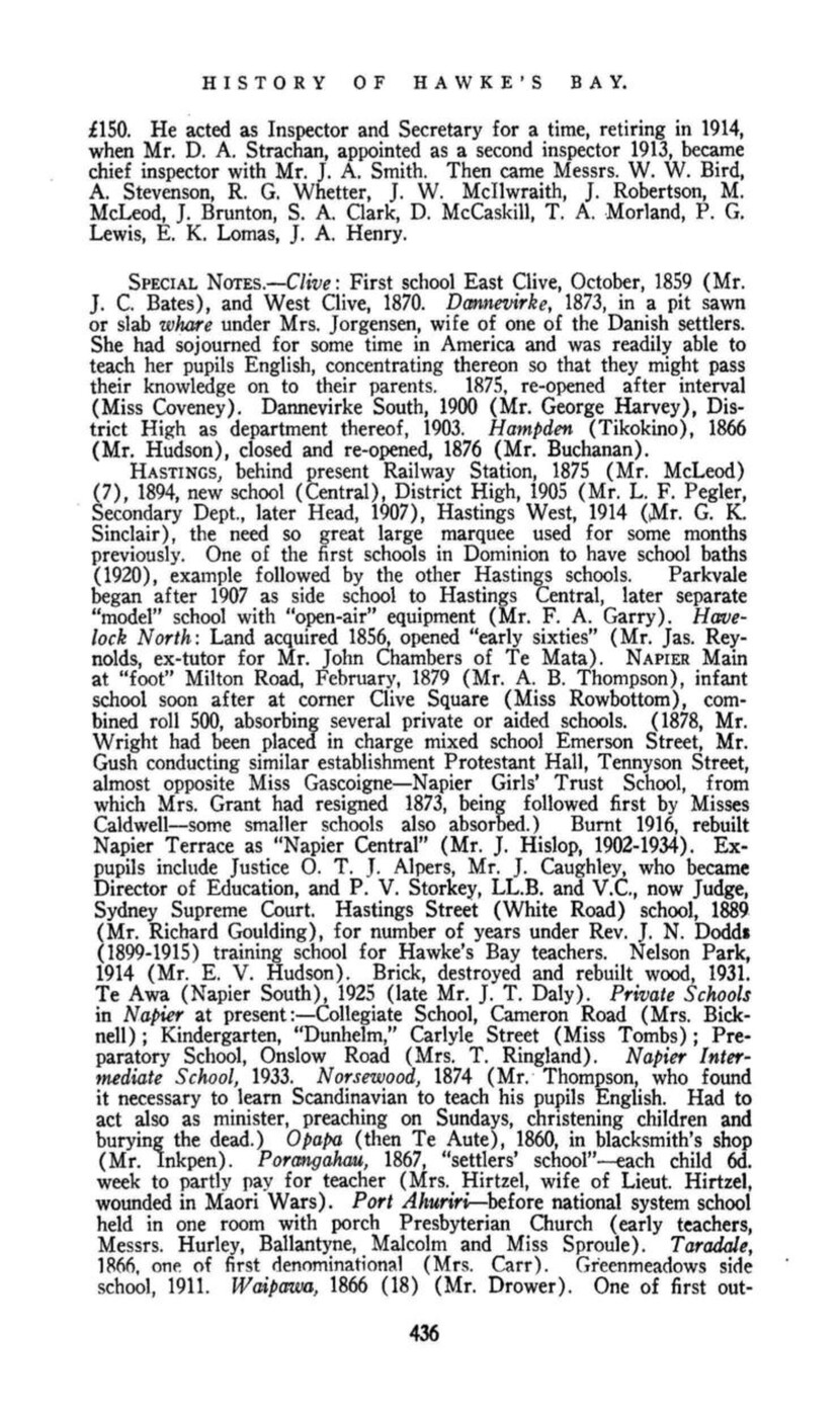
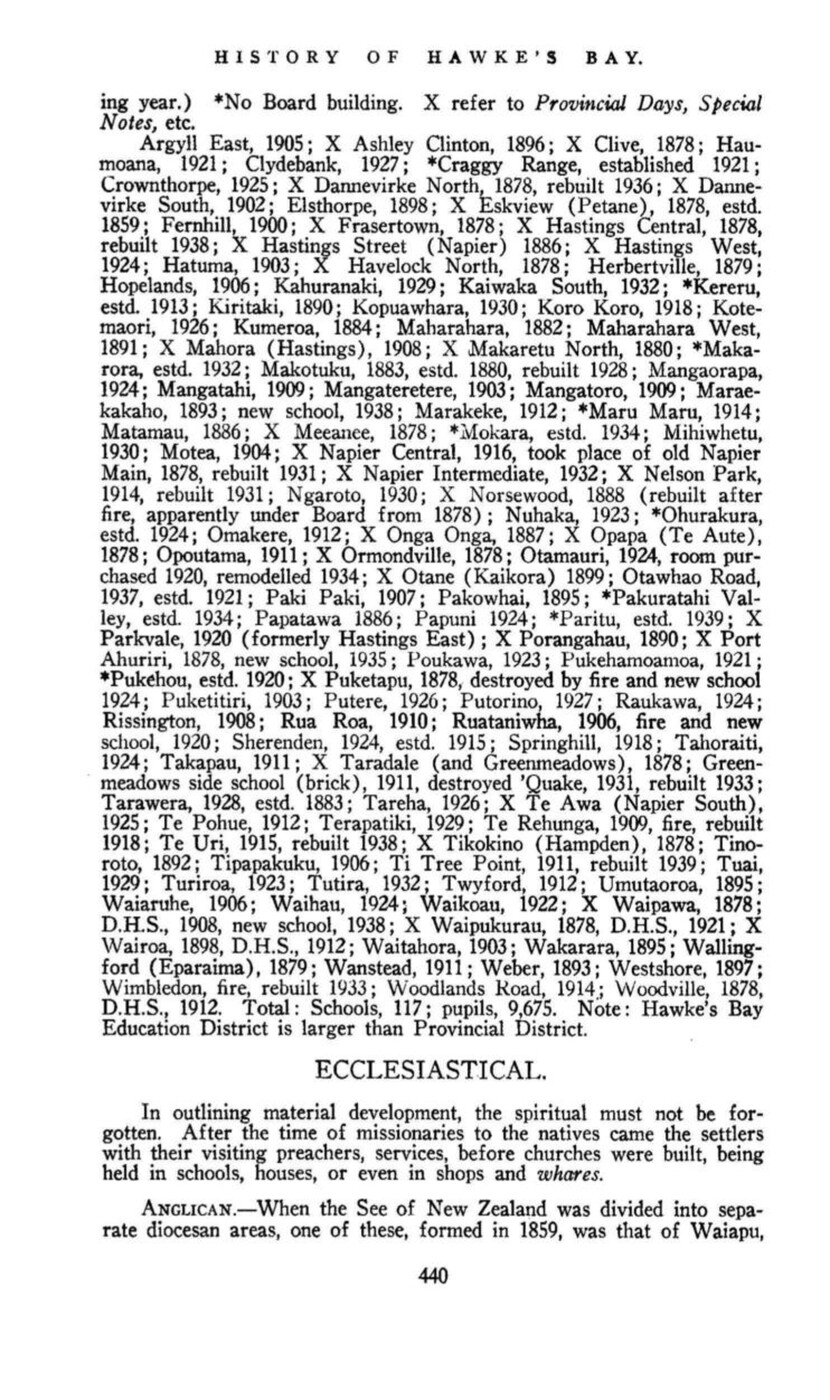
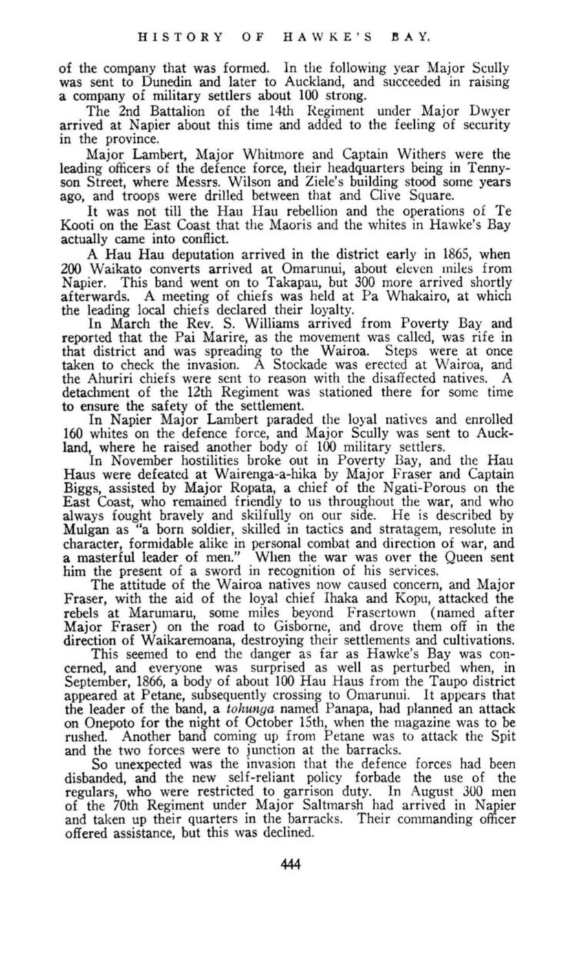
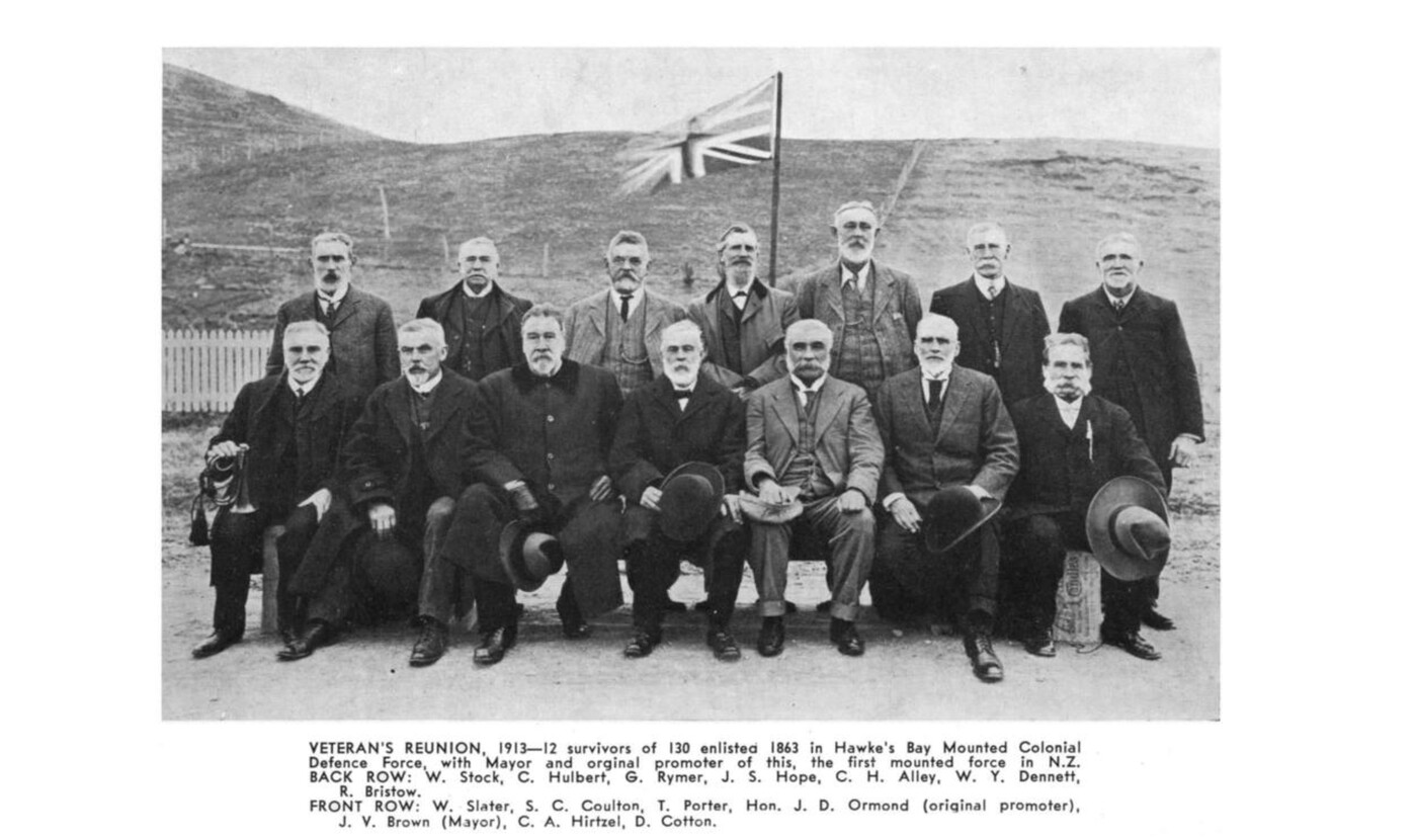
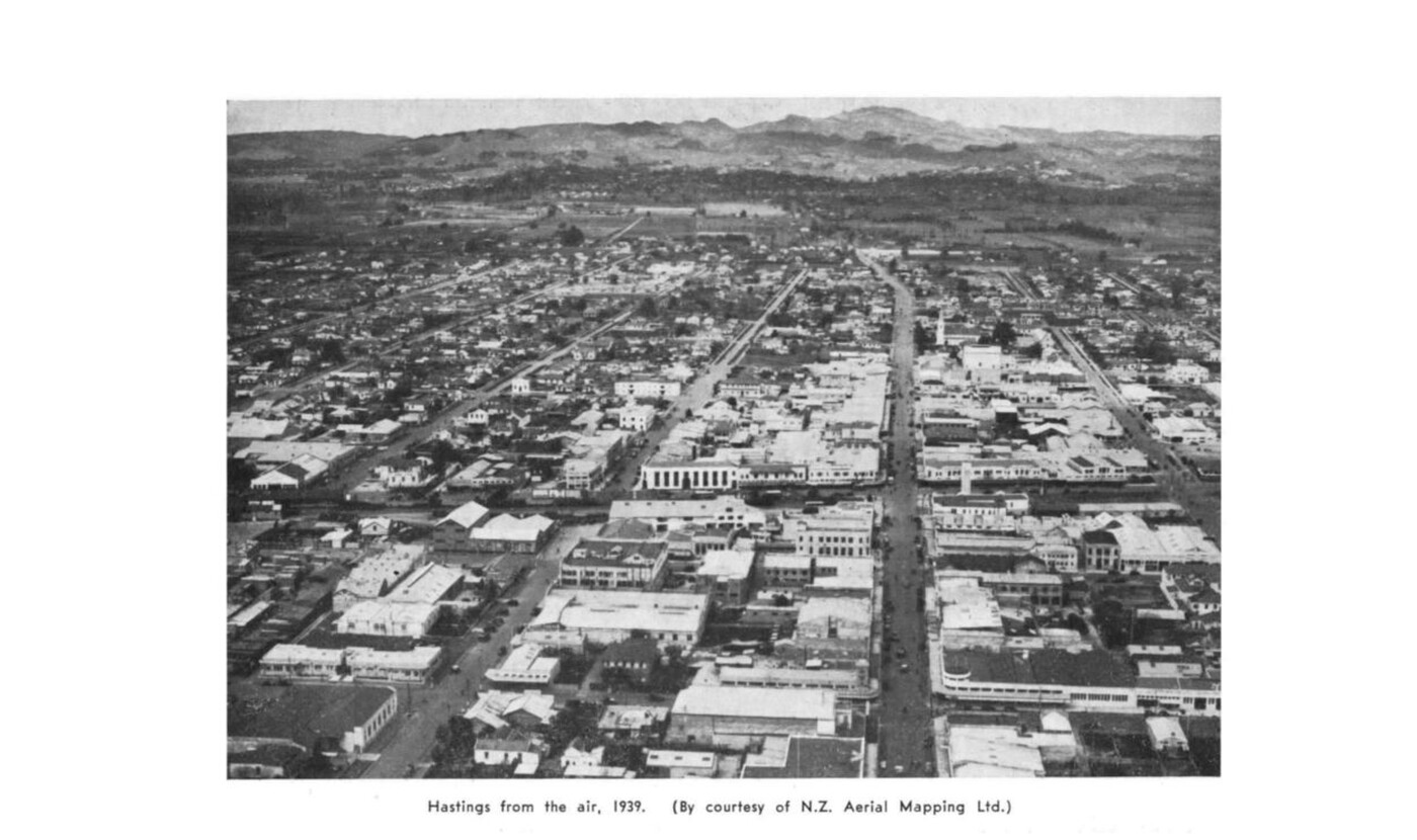
Page 451
EARTHQUAKES IN HAWKE’S BAY
THE EARTHQUAKE OF 3rd FEBRUARY, 1931.
AN OVERWHELMING DISASTER.
SEVERAL TOWNS WRECKED.
COUNTRYSIDE DEVASTATED.
Such newspaper headlines did not exaggerate. The total loss was 246 lives and several millions in property throughout Hawke’s Bay, besides thousands injured and a number permanently unnerved or insane. Napier, which suffered the most heavily, lost probably at least £5,000,000 in property and 151 lives, of which 32 were in the Taradale-Greenmeadows district. Hastings deaths totalled 92, Wairoa 2, Mohaka 1.
The epicentre of the ‘quake appears to have been out at sea, opposite Wairoa and Waikari, where the sea cliffs were lifted bodily 40 feet. This lift decreased towards Napier from six or eight feet to three or four feet, dying out altogether towards Clive. This lifting, as we know, reclaimed the Inner Harbour. The extreme violence of the shock wrecked Napier and Hastings, brick and concrete buildings being reduced to piles of debris, while roads were rendered impassable, the main ones for a short time with cracks and cave ins – soft fillings were completely shattered – the country ones by huge slips. An enormous landslide dammed the Te Hoe River, and made a large temporary lake. Hills slipped into valleys, cliffs were thrown down, streams disappeared. The whole face of the country was cracked and scarred with slips.
Drainage, gas and water services were completely disrupted in Napier, where two small fires, starting in Hastings street, took charge, and in a few hours consumed the entire heart of the business area – a strange and fearful spectacle. In Hastings the water supply was broken at the Havelock North bridge. Three fires simply burnt themselves out, fortunately without spreading through the town.
In Napier, the timely intervention of a highly organised band of sailors from H.M.S. Veronica will never be forgotten, and the Veronica bell on the Parade is an enduring memento of the occasion.
A Committee, under Mr. Wohlman, Commissioner of Police, as Chairman, with Mr. J. Girling Butcher as Secretary, was formed in Napier on 4th February, and began at once to grapple with the situation. A hand-set single sheet Daily Telegraph, issued the very day after the ‘quake, 4th February, gave the names of the Executive. In addition to Hon. W. Masters, as Minister of the Crown, there were also Commodore Blake (H.M.S. Veronica), H.W. the Mayor of Napier (Mr. J. Vigor Brown), the Chairman of the Hawke’s Bay Hospital Board (Mr. C. O. Morse, (Mr. (now Hon.) W. E. Barnard, M.P., with various sub-committees.
The Hawke’s Bay County organised its men so rapidly and effectively that by the end of the first day (3rd February) cars were coming through, and the more seriously injured were being rushed in car-loads to Waipukurau, Dannevirke and Palmerston North for treatment – later as far as Wellington and Wanganui. The exodus of terrified refugees began, and was at its height the following day.
Refugee camps for the homeless were established at Nelson Park (vide news sheet of 5th), etc., in Napier, and in Hastings. The same news sheet also mentions the establishment, to replace Napier Hospital, where a temporary dressing station had been established beside the ruins, of a “permanent” hospital at the Napier Park Racecourse, making use of the existing buildings there and marquees. Food depots – the first organised by Veronica men at the Hastings Street School, Napier, the
Page 452
HISTORY OF HAWKE’S BAY.
very night of the earthquake, were established, and a form of rationing soon introduced.
The authorities, with drainage and water out of commission and organisation of large food supplies difficult, to avoid distress and epidemics ordered evacuation of all but those engaged in essential tasks. By 6th February train services had been re-established, and free passage was given to hundreds of refugees. People in other provinces generously billeted these in their homes, while organisations rushed in food and medical and other supplies. For a time there were little more than two thousand left in Napier, mostly men, and registered by cards.
The Post and Telegraph men quickly had a telegraph service in working order. The Post Office, as well as the main food depot, was the Hastings Street School, till the 7th, when all the Post Office but the Telegraph delivery branch was transferred to the Hawke’s Bay Farmers’ building opposite the Railway Station.
After Napier and Hastings, Wairoa suffered most severely, there being, as noted, three deaths (one, Mohaka), but there was mercifully no fire. Like them, it also suffered severely in the second ‘quake of February 13th.
REHABILITATION. – £400,000 was contributed by the people of New Zealand to help earthquake sufferers, many of whom had lost their all; depots for clothes, crockery, etc., were established by the Red Cross at Napier, Hastings and Wairoa, that at Napier being kept going for a considerable time.
Government loans were made to re-establish businesses and rehabilitate homes. A chimney each was first supplied to returning refugees, and £100 worth of repairs done to their homes. During reconstruction there was a “tin town” period in Napier and Hastings, Napier having a whole temporary shopping area of this type. A heavy burden of debt has long remained to remind these towns of the event.
Commissioners appointed by the Government, Messrs. J. S. Barton and J. Campbell, assisted by a Committee, supervised rebuilding, and in three years a Carnival celebrated a new Napier of wider streets and ‘quake proof reinforced concrete buildings of simple and impressive design, making Napier a town unique.
Page 453
CHRONOLOGICAL SUMMARY.
1840-1850.
23rd June, 1840, Treaty of Waitangi signed by three Hawke’s Bay chiefs, but Hawke’s Bay remained no-man’s land, visited by whalers and traders, who also established shore stations and stores along the coast. Missionaries came; the most noted, William Colenso, arrived 1844, famed as explorer, author, printer, diarist and botanist.
1850-1860.
By 1850 first settlers beginning to come up coast from the Wairarapa, driving their flocks and herds. Donald McLean began Crown purchases of land from the Maoris, and Napier was founded 1855, when much of country already settled for some years. 1st November, 1858, Hawke’s Bay Province formed by separation from Wellington.
1870-1880.
Provincial Council brought Scandinavian immigrants, founding Norsewood, Dannevirke, etc., in great 40 Mile Bush, which now began to disappear: Napier-Wellington railway begun 1872. Taupo road open for coaches 1874. Provincial Governments abolished November, 1876. Four Hawke’s Bay Superintendents: – T. H. Fitzgerald, 1859-61; J. C. Lambton Carter, 1861-62; Donald McLean, 1862-69; J. D. Ormond, 1869-76.
1880-1890.
Sheep farming saved from long and severe depression by introduction Meat Freezing. Tomoana Works opened by William Nelson 1884. Railway completed to Dannevirke 1884, to Woodville 1887. Napier Breakwater commenced 25th January, 1887. Bush destruction now proceeding apace – sawmilling, felling, burning. 1888 tremendous bush fire swept Norsewood area – destroyed much of township.
Page 454
1890-1900.
Large estates now began to be sub-divided, days of squatter were passing away. Railway open to Palmerston 1891, Masterton 1897. 1897 great flood covering much of Heretaunga plains, Clive being isolated and rescue party of ten drowned. Napier becoming tourist centre of ever increasing importance, particularly since opening Taupo road, in 1874, and other routes. Industries developing.
1900-1920.
Several small farm settlements cut up from big estates: – Elsthorpe, Hatuma, Argyll, Ruataniwha, etc. Gas, then electricity, into general use in towns. Motor cars begin, electric tram cars. East Coast Railway commenced 1912. Hawke’s Bay played worthy part Boer and Great Wars. Wooden era in towns giving place to brick and concrete.
1920-1940.
Period of rapid motorisation, improvement of communications, increasing commercial and industrial development. Hawke’s Bay Aero Club 1928. Napier-Gisborne regular aeroplane service 1935. East Coast Railway opened to Wairoa 1st July, 1939. Great earthquake 3rd February, 1931, Hastings wrecked, Napier business area burnt and destroyed, now unique, all modern tinted concrete architecture.
Note re Dates: The question of adjusting Cook’s dates was dealt with in an article entitled “Vexed History” printed in the New Zealand Centennial News, issue dated May 29, 1939, to which the interested reader is referred. This shows the method to be adopted when amending Cook’s dates to allow for “westing,” and also for the two systems of keeping time (“ship’s” and “civil” time) (c.p., page 121, re Sydney Parkinson, where Cook’s date had been “adjusted” by Hawkesworth). The dates quoted herein, taken from the usual authorities, have not been so amended.
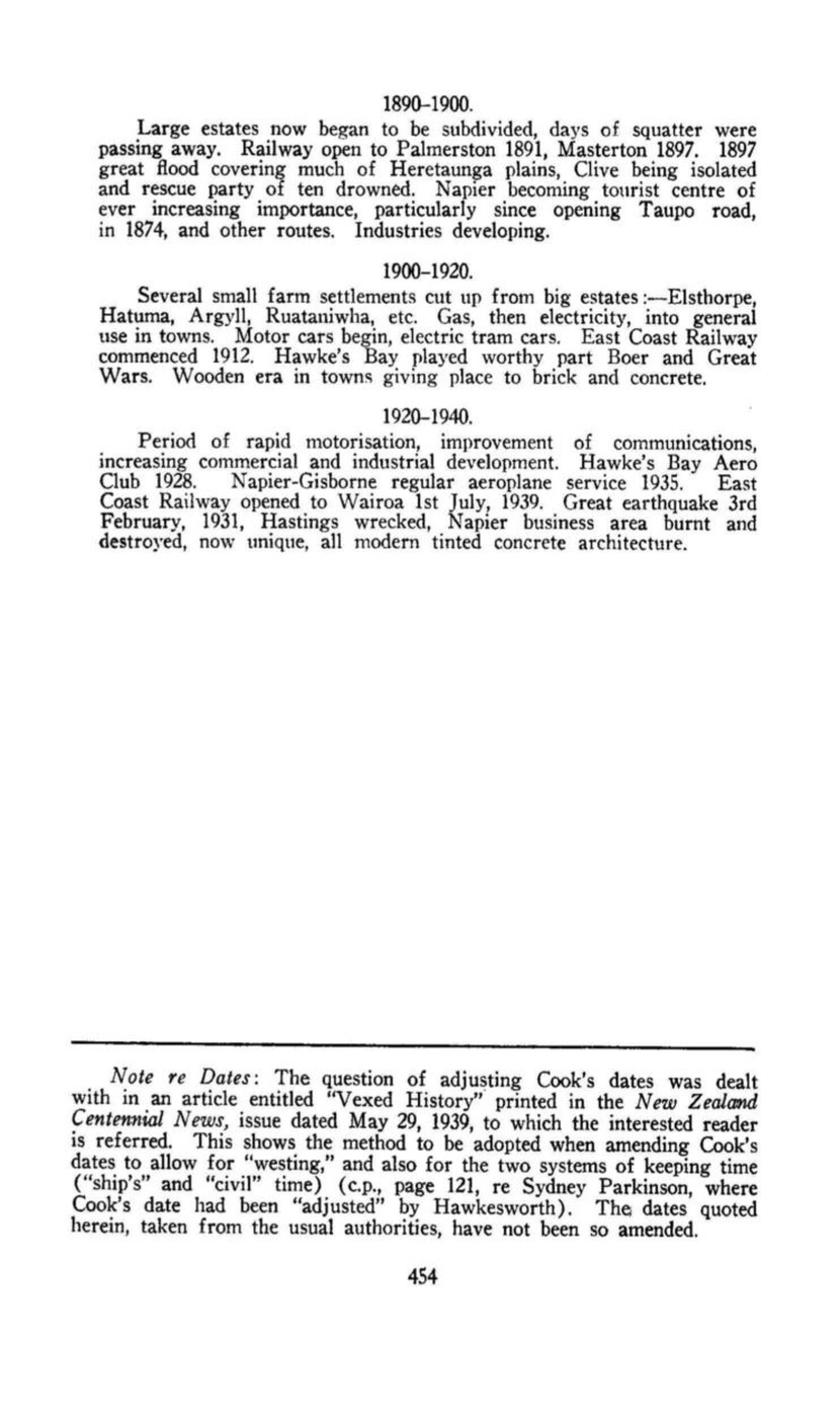
Page 455
BIBLIOGRAPHY.
Books Relating to or Containing References to Hawke’s Bay.
Acland, L. G. D. Early Canterbury Runs 1930
Acts and Proceedings of the Provincial Council of Hawke’s Bay 1859-1875
Adam, James Twenty-five Years South and N.Z. 1876
Alpers, Hon. O. T. J. Three in a Coach 1891
Alpers, Hon. O. T. J. Cheerful Yesterdays 1928
Appendices to Journals of the House of Representatives 1861- –
Appendix to Church Almanac of N.Z. 1867
Asher, Rev. J. A. Presbyterian Church Historical Survey 1935
Banks, Sir Joseph Journal 1 896
Barraud, C. D., and Travers Provincial Views 1877
Bathgate, Alexander Colonial Experiences 1874
Before and After (Daily Telegraph Co.) 1931
Berry, Dr. J. Allan Volcanic Deposit –
Berry, Dr. J. Allan Scinde Island 1928
Blake, A. Hope Sixty Years in N.Z. 1909
Bourke, E. M. A Little History of N.Z. for Children (First Edition date, 1880)
1882
Bradshaw New Zealand as it is 1883
Brett, Sir Henry N.Z. South Pacific Pilot 1886
Brett, Sir Henry White Wings 1924
Browne, Col. G. H. With the Lost Legion in N.Z. 1911
Browne, Col. G. H. Camp Fire Yarns of the Lost Legion 1913
Buckingham, Duchess of Glimpses of Four Continents 1894
Buick, T. Lindsay The Mystery of the Moa 1931
Buick, T. Lindsay The Discovery of the Dinornis 1936
Bull, F. Dominion Ditties 1910
Bunbury, Major Reminiscences of a Veteran 1861
Burns, Barnet A Brief Narrative (Adventures at Mahia, etc.) 1844
Butler, Annie R. Glimpses of Maori Land 1886
Clarkson, Ruth Brick Dust 1931
Colenso, Rev. W. Excursions in the Northern Island of N.Z., 1841-42 1844
Colenso, Rev. W. Fiat Justicia 1871
Colenso, Rev. W. First Crossing of Ruahine Range 1884
Page 456
Colenso, Rev. W. Fifty Years Ago 1888
Colenso, Rev. W. Ancient Tide Lore 1889
Colenso, Rev. W. Church at Ahuriri 1889
Cook, Capt. James First Voyage, 3 vols. 1773
Cook, Capt. James Second Voyage, 2 vols. 1777
Cook, Capt. James Third Voyage, 3 vols. 1785
Cook Capt. James Journal of First Voyage, Wharton, Cap. W. J. Z. (Edition) 1893
Coote, Walter Wanderings South and East 1882
Cowan, James The N.Z. Wars 1922
Cowan, James Travel in N.Z., Vol. I. 1926
Cowan, James Sir Donald McLean 1939
Cox, Alfred Recollections 1884
Coxon, A. E. Provincial Days in Hawke’s Bay (Thesis) 1938
Cyclopedia of New Zealand, Vol VI. 1906
Daily Telegraph (Napier), including Earthquake leaflets, Feb., 1931 1877 –
Dannevirke North School Diamond Jubilee (Booklet) 1936
Dannevirke Presbyterian Church Jubilee (Booklet) 1937
Dickson, Rev. John History of Presbyterian Church in N.Z. 1899
Dinwiddie, W. Old Hawke’s Bay 1916
Dinwiddie, W. Old Hawke’s Bay, Part II. 1923
Douglas, Sir Arthur The Dominion 1909
Duncan, Russell Early Walks 1918
d’Urville, Capt. Dumont Voyage of the Astrolabe 1830
Earthquakes Illustrations – Napier 1933
East Coast Maori War By an Old Veteran –
Elkington, E. W. Adrift in N.Z. 1906
Everybody’s Weekly (H.B.) (W. Dinwiddie Lectures) Jan., 1927
Facsimile of Treaty of Waitangi 1877
Firth Nation Making 1890
Fitton, Edward B. New Zealand, etc. 1856
Forster, George A Voyage Round the World, 2 vols. (with Cook) 1777
Fuller, Francis F. Five Years’ Residence in N.Z. 1859
Gascoyne, Major F., and Preece Soldiering in New Zealand 1916
General Government Gazettes 1853- –
Gill, S. T. Rambles at the Antipodes 1859
Grace, Thos. Saml. (about) A Pioneer Missionary Among the Maoris (by S. J. Brittan, etc.) 1928
Gretton, Lieut.-Col. History of the Royal Irish Regiment 1911
Gudgeon, J. W. Reminiscences of the War in N.Z. 1879
Gully, John N.Z. Scenery, 15 plates 1877
Hamilton, G. D. Trout Fishing … In Maoriland 1904
Handbook of New Zealand 1875
Harrop, A. J. England and the Maori War 1937
Hawke’s Bay Daily Times 1861-1871
Hawke’s Bay Herald 1857 – –
Hawke’s Bay Native Lands Alienation Commission 1873
Hawke’s Bay Provincial Council Blue Books 1859-1875
Hawke’s Bay Provincial Council Gazettes 1859-1873
Hector, James Handbook of N.Z. (Statistics) 1886
Heywood, B. A. A Vacation Tour of the Antipodes 1863
Hickson, Rev. Father Catholic Missionary Work in Hawke’s Bay 1924
Page 457
Hiscocks, E. T. Saints and Sinners –
Hiscocks, E. T. Caricatures of Napier Citizens –
Hitari te Paeratu Battle of Orakau 1888
Horsley, Reginald New Zealand’s Romance of Empire 1908
Hunt, Fred Twenty Five Years in N.Z . 1886
Inglis, Hon. James Our New Zealand Cousins 1888
In Memoriam of Samuel Williams, 1822-1907 1907
Johnston, His. Hon. Judge Address to Grand Jury at Napier 1861
Jourdain, Wm. Robert Land Legislation and Settlement 1925
Jubilee of Primitive Methodism in New Zealand 1883
Kent, Isaac East Coast Maori War (Pamphlet) 1866
Lambert, Thos. Old Wairoa 1925
Lambert, Thos. Pioneering Reminiscences of Old Wairoa 1936
Lambert, Thos. The Northern Area (Additional to H.B. Centennial History MS)
1939
Lawlor, Pat Confessions of a Journalist 1935
Lyng, J. The Scandinavians in N.Z. (from Norden, Melbourne MS Turnbull) 1931
Mackie, J. J. N. History of Kereru and Wakarara (MS) 1933
Malcolm, A. H. Early History of Hawke’s Bay (Thesis) 1930’s
Maps of Hawke’s Bay, 1852-56-61-74-88
Martin, Lady Our Maoris 1884
McLean, P. S. Native Land Laws of N.Z. 1886
McNab, Robt. Tasman to Marsden 1914
Meade, Hon. Herbert R. N. A Ride Through the Disturbed Districts of N.Z. (Tauranga to Napier) 1871
Mennell Dictionary of Australian Biography 1892
Meredith, G. L. Adventures in Maoriland in the Seventies 1935
Morley, Rev. Wm. History of Methodism in N.Z. 1900
Nesfield, Henry W. A Chequered Career 1881
New Zealand Advertiser (Wellington) 1865-1868
New Zealander (Auckland) 1845-1874
New Zealand Herald and Auckland Gazette 1842
New Zealand Index (Every place in N.Z.) 1915
New Zealand Roll of Honour 1924
New Zealand Spectator and Cook Strait Guardian 1844-1865
New Zealand Various Obituaries (Press Cuttings – Turnbull Library) –
Norsewood History (Press Cuttings – Turnbull Library) 1921
Parkinson, Sydney A Journal of a Voyage to the South seas 1773
Payton, E. W. Round About New Zealand 1888
Peppercorne, F. S. Monographs 1879
Polack, J. S. Travels and Adventures in N.Z., 2 vols. 1838
Polack, J. S. Manners and Customs of New Zealanders, 2 vols. 1840
Pow, Doris Hutchinson William Colenso (Thesis, Turnbull Library) –
Purchas, Henry Thos. History of the English Church in N.Z. 1914
Ramsden, Danl. Chronicles of the Nairn Family (MS) –
Reeves, William Pember The Long White Cloud 1898
Reeves, William Pember New Zealand 1898-1908-1927
Report of Royal Commission on Te Aute College Trust 1907
Report of the Enquiry into the Heretaunga Purchase –
Page 458
Rich, George Journal (MS) 1852
Rochfort, John Adventures of a Surveyor 1853
Roe, Robina Agnes (Mrs.) Early Days of Westshore and Eskdale 1929-1938
Ropata, Major Early Days of Poverty Bay 1923
Rusden, G. W. History of N.Z. 1883
Rusden, G. W. Aureretanga 1888
Saunders, Alfred History of N.Z. 1896
Scholefield, Dr. G. H. New Zealand in Evolution 1909
Scholefield, Dr. G. H. Who’s Who in N.Z. 1925- –
Selwyn (Bishop) Annals of the Diocese of N.Z. 1847
Senior, William Travel and Trout 1880
Sherry and Wallace Early New Zealand 1890
Shipping List H.B. (MS). Compiled from Well., 1855-70, and Auck., 1842-64, newspapers.
Shipwrecks – N.Z. Disasters, 1795-1926 1937
Simkin, Kate Louisa Te Makarini, a N.Z. Statesman (Thesis, Turnbull) –
Smith, H. Guthrie Birds of the Water, Wood and Waste 1910
Smith, H. Guthrie Mutton Birds and other Birds 1914
Smith, H. Guthrie Tutira 1921
Smith, H. Guthrie Bird Life on Island and Shore 1925
Smith, H. Guthrie Sorrows and Joys of a N.Z. Naturalist 1937
Taradale Jubilee, 1886-1936 1936
Thomson, Dr. A. S. The Story of New Zealand, 2 vols. 1859
Tinney, J. E. The Wonderland of the Antipodes 1873
Transactions of the Committee of the Ahuriri Settlers’ Association 1856-1858
Transactions of the N.Z. Institute 1868- –
Tucker, Miss Southern Cross and Southern Crown 1855
Turton’s Deeds (Land Purchase Records) –
Vogel, Julius Official Handbook 1875
Votes and Proceedings of Hawke’s Bay Provincial Council 1959-1875
Ward, Sir Joseph (about) Unauthorised Biography –
Wellington Independent 1845-1874
Wellington Provincial Council Blue Books 1854-1876
Wellington Provincial Gazettes 1854-1876
Whitmore, Sir George Letters to McNeil (MS) 1861-1862
Whitmore, Sir George Last Maori War in N.Z. 1902
Williams, Bishop W. L. East Coast Historical Records 1932
Williams, W. T. (Ed.) Pioneering in N.Z. (Biog. Saml. Williams) 1929
Wilson, J. J. The Church in N.Z. 1910
Wood, James Acts of the Province of Hawke’s Bay 1866
Woodhouse, A. E. George Rhodes … and his Brothers 1937
Woodville D.H.S. Diamond Jubilee and Borough Jubilee 1937
Fiction by Hawke’s Bay writers: Ruth and Olive Ellison, nieces of the Very Rev. Dean de Berdt Hovell, the first Dean of Waiapu, two sisters: – “Sandy and Co.” (1925) and the “The Road of Life: (1927) respectively, the former appearing as a H.B. Herald serial in 1924; have also published a wide variety of stories, verses, etc., in journals and magazines. D. Carman – “The Broad Stairway” (1924). Beryl McCarthy’s “Castles in the Soil” (1939) contains references to the Mohaka Massacre.
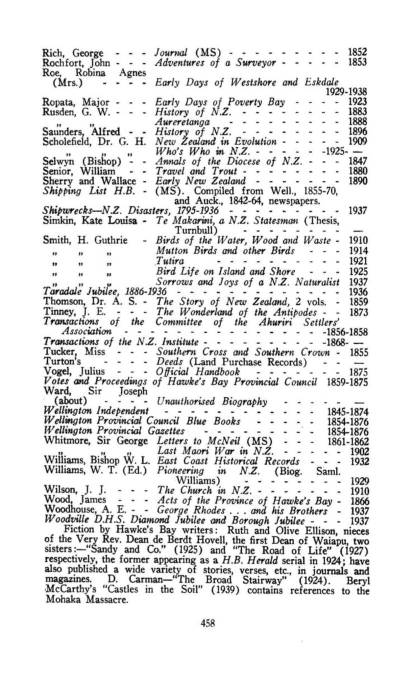
Page 459
INDEX.
The following groupings have been made: –
I. MAORI: Chiefs, Leaders, etc.; Women; Fights; Invasions, Raids, and War Parties; Pas, Kaingas and Place Names; Tribes and Hapus; Lists.
(Note: For attacks on pas, look under name of pa; where battle named after Chief, look under Chiefs. Where well-known Chief or pa (as Waipukurau) missing, look in General Index. Where Maori names are not to be found under own letter, look under “Te,” and vice versa; also “Ngati” for tribes.)
II. GENERAL INDEX: Lists
(Note:” Owing to space limitations, several subjects have been grouped under names of Headings, as Educational, Ecclesiastical, Military, etc.
I. MAORI.
CHIEFS, LEADERS, ETC.
Aria, 54, 81; Awarua-o-Porirua (taniwha), 23-4; Hawea, 71-2, 75-7, 82, 86; Hika Ororoa, 58; Hikateko, 70; Hikawera, 52-3, 64, II, 70, 72, 81; Huikai (lad), 62; Humenga, 78, 83, 95; Hunga Hunga, 90-1; Hura Kohu Kohu, 105; Iwikatere, 36-7; Kahungunu, 24, 26-31; Kahuparoro, 33-4, 39, 51; Kahutapere (32-3), 47-8, 57 (70); Kaiwaru, 84; Karawa, 98, 108; Kawakawa, 71-2, 85; Kii Pata, 80; Koha, 95-6; Kora Kora, 91-2; Koura, 101-2; Manawakawa, 75-6; Maui, 20, 22, 26; Meke, 82, 102-3; Ngamoa, 75-7; Ngaroro, 90; Ngarengare, 37; Nikora (Hauhau), 55-7; One One, 78, 95; Paerikirikiri (spy), 99; Pakapaka, 54, 92, 95, 104-6; Pakaru, 77, 82; Poara Kaiwhata, 56, 104; Pareihe, 56, 84, 90-2, 94, 96, 99, 100-1, 103, 280; Pawa (giant), 25-6; Pokia, 65-6; Potatau (Waikato), 98; Rakaihikuroa, 32-5, 52, 62; Rakai the Ugly, 38-9; Rakaipaka, 36-7; Rangipungangana, 51-2; Rangis, feud of two, 73-4; Rangitane, 24; Rangitaumaha, 65, 69, 70; Rangitawhiao, 35; Rangitotohu, 85; Rewha Rewha, 80, 84; Ringanohu, 85; Rongokako (giant), 20, 24, 25-6, 29, 30; Ruamano (monster), 42; Ruruku-o-te-Rangi, 81; Ruruau, 70, 80-1; Tahoto Ariki, 76, 78, 83-4; Tahumate, 76-7; Takaha, 61-2, 64; Takotoroa, 79, 87-8; Tama Ariki, 62-3; Tamatakutai, 29-30; Tamatea, 27-8, 30, 38; Tamatera, 36-7; Tangi Hararu, 52; Tangi te Ruru, 86(7); Tara (First Maori in H.B.), 21-4, 47, 53-1, 56 (lake of); Taraia, 31, 35-40, 42-6, 59066, II, 74-6, 84;
Tareahi, 80-1, 104; Tarewai (called Tareahi), 81; Tatapora, 78-9; Tauwhao (garden of), 40; Te Amio Whenua, 77; Te Anau, 51-2; Te Aokamiti, 65-6; Te Arawai, 90, 94; Te Ari Ari, 60-3; Te Hauwaho, 78, 80, 83,
Page 460
90-2, 95, 100, 104-7; Te Heuheu, 54-5, 88, III, 89, 93, 96-9, 101, 104, 315; Te Hoeroa, 86, 90; Te Iwikau, 104; Te Kahu-o-te-Rangi (Hawk of the Skies), 93, Te Kaori, 105; Te Kauru, 104; Te Kauru-o-te-Rangi, 80, 83; Te Koau Pari, 27, 41, 48; Te Kohi-pipi (shellfish gatherer), 48-50; Te Matenga, 95, 108; Te Momo, 98-100; Te Motu Motu, 89, 99, 101; Te Nahu, 86-7, 196, 198(9); Te Operoa, 81; Te Paku-o-te-Rangi, 81; Te Puke, 99, 101; Te Rangihirawera, 73-4; Te Rangikamangungu, 71-2, 81-2; Te Rangikawhiua, 73-6; Te Rangikoianake, 71, 76, 81-2, 84-5, 88, 199; Te Rangituoru, 75-6; Te Rehunga, 75-7; Te Rei, 93 (Te Ipu-o-te Rei); Te Rimu, 79-80; Te Ruruku, 82; Te Taha, 77; Te Tomo (servant), 53; Te Uamairangi, 72, 75, 76-8, 80, 83; Te Wanikau, 76, 80, 86-8, 104; Te Waru, 105-6; Te Weka, 77-8; Te Wera, 56, 91-2, 94, 96-7, 99, 100; Te Whakahemo, 84, 86; Te Whaka-whiuranga, 60, 62-3; Te Whatuiapiti, 52-3, 62-70, 73-5; Te Wheao, 71; Te Whiu Whiu, 86; Tiakitai, 97-9, 104, 156; Tiakiwai, 79; Toi Kairakau (Te Huatahi), 20-2, 24, 26, 29, 41, 48; Toirauta, 79; Toromata, 105; Totara, 40, 4304; Tu Ahuriri, 46, 57-9; Tuku, 71; Tukutuku, 66, 68-9; Tumihi, 77; Tunui, 54; Tu-nui-a-Rangi, 41-2; Tupurupuru, 31-5, 51-2; Turangiapa, 48-9; Turauwha, 43; Tureia, 47-8; Tutara, 72; Tutekawa, 58; Tuterangi, 65-6; Werewere, 54; Whakato, 83-4, 90-2, 95, 104-5; Wharepakau, 41; Wharetoetoe, 55 (head of); Whatanui, 85, 89-90, 96, 102-3, 105-7, 156; Whatonga, 21-2, 279; Whiuwhiu Hoia, 99, 101, 148; Wi te Manga, 97; Wharekotore, 51-2.
WOMEN.
Hinahina Ariki, 71; Hinehore, 69; Hinepehinga, 66, 68-9; Hineiroia-te-Rangi, 82; Hineitangihia, 79; Hineiterangi, 47-8; Hinehakoroa (priestess), 51; Hinekatorangi, 42 (lake of); Hinekura, 35(6); Hinepare (Lady of the Plumes), 39, 63-4; Hine Te Aorangi, 65; Hineteko, 69; Hinetemoa, 37, 69; Hirawanui, 103; Huhuti, 65, 69-70, 74-5; Muriwai, 41; Paeora, 102-4; Rongomaiwahine, 29-31, 58; Te Ahi Matutunu, 48, 50; Te Herepou, 79; Te Kaihou, 85; Te Uira, 54; Te Uira a Waho, 52-3; Te Upokoiri, 75-6; Te Wawhanga-o-te-Rangi, 70, 74, 76; Te Whakapakaru, 70, 72; Tiria (daughter of Potatau with European husband), 98.
FIGHTS.
Hauhau (massacre), 35; Herepoho (Eskdale), 57; Heruiwi (destruction Urukehu), 41; Korongata, 85; Mangatoetoe, 84-6, 106; Matau-a-Maui, 280; Ngahape, 83; Otaparoto, 90; Paepae-ki-Rarotonga, 33; Paherumanihi, 72; Panui, 83; Paratuna, 83; Paruparu, 71; Tane-nui-a-Rangi, 37; Tapuaerau, 84; Tara Whitiwhiti, 89; Tawhitinui (massacre), 65-6; Te Awa-a-te-Atua (The River of God) (place, 78, 96), 107; Te Aketia (massacre), 36-8; Te Humatorea (massacre), 35; Te Kaipo, 79; Te Roropipi, 66; Te Umu Inanga, 97; Te Wharemakau, 64; Te Whiti-o-Tu, 92, 96, 280; Tiparehuia, 65, 69; Turning About Faces Fight (Aroarotahurihuri), 45; Upoko Poito, 66-8; Waikoau Fight, 39-40; Waitemoa, 90; Whakamarino, 82.
INVASIONS, RAIDS AND WAR PARTIES.
Fugitives from Turanga, 33-7, 37-40, 43-5, 47-8, 50-4 (Coastal Party, 33-6; Inland Party, 36-7; Main Raid on Heretaunga, 43-5); Various, 38, 43-5, 56, 68, 60-1, 63, 71-2, 75-9, 85-90, 93-106, 108.
PAS, KAINGAS AND PLACE-NAMES.
Aorangi, 86; Arapaonui, 38-9, Aratipi, 88; Awakari, 60; Arapuni, 91; Awapuni, 183; Hatepe, 54; Hauhau, 107; Heipipi, 40-2, 45-6; Hikurangi, 41-3; Kahotea, 99, 100; Kaiorerau, 87, 288; Kai-uku, 92, 96-7; Kapu-te-rangi, 21; Karamea, 86; Kauhanga, 61, 63; Keteketerau (Outlet Inner Harbour), 27, 42, 59, 93; Kihiao, 85; Kohinarakau, 91, Kohukete, 63,
Page 461
95-6; Korongata, 61-2, 77; Koturoa, 82; Kowhai, 75; Manautehi, 103; Maraekakaho, 75, 86, 386; Matairangi, 51-2; Matapane (site Napier), 72; Matapiro, 75, 86; Maunga-a-Kahia, 309; Maungapuremu, 32; Moana-i-Nokia, 87; Motu, 41; Motu Kumara, 82-3; Nukutaurua (Mahia), 22-9, 33-4, 51, 81, 85, 91-2, 94-9, 102-3, Chap. 85-98; Okoraka, 85; Okurarenga, 97; Omahu, 28, 92; Omakukukara, 103; Omana, 75; Omaratairi, 91, Oneroa, 69-70; Oponini, 40; Opunua, 77; Otaia, 72; Otatara, 41, 43-6, 59, 65, 80; Otiere, 27; Otoio, 48-51; Pakake, 91-2, 94-5, 97-8, 100, 102-7, 117, 198; Pakira-a-Hikawera, 53; Papoto, 71; Parapara, 93-4; Pare Waiehu, 78; Parinui-o-Whiti, 77; Paritua, 75; Pawhare, 83; Pohatunui-a-Toru, 65-6; Pukeake, 75; Pukenui, 48-9; Pukepoto, 33; Puketatarariki, 77; Putere, 93-4; Putiki Wharanui (settlement), 28, 32; Rahokatoa (kainga), 107; Rakautihia, 36; Rangihu, 40; Raukawa, 44, 70, 75, 88, 93; Roto-a-Kiwa (lake), 23; Rotowhenua (kainga), 107; Tahau, 51; Tahunamoa, 59-61, 63; Takutai-o-te-Rangi, 66; Tane-nui-a-Rangi, 77, 21-3, 91; Tapuarau, 65-6; Tatakaka, 60; Taumata-o-he, 75, 78-80, 86; Tawhitinui, 71; Te Awahou-a-Te Pourewa, 60; Te Awanga, 73, 77, 83, 85, 87, 135; Te Hika Pukanohi, 62; Te Iho-o-te-Rei, 79, 93-4; Te Iho-Torohanga, 103; Te Kaihou, 107; Te Kairae, 71-2; Te Koau, 105-6; Te Kapua (kainga), 107; Te Kauhanga, 63-4; Te Kopua, 91; Te Kupenga, 51, 55; Te Ngaio, 78; Te Ngaru, 49 (50); Te Ngaue, 85, 108; Te Pou-a-te Rehunga (Onepoto), 103; Te Putere, 48, 93; Te Roto Kari (kainga), 107; Te Umu-o-put, 102; Te Waiharakeke, 88; Te Wheao, 71, 73-4, 77, 85, 107; Tiki Whakairo, 85, 86; Toko Toki, 78, 80; Tokomaru, 83; Tokorangi, 77; Toropapa, 51; Totoapua, 289; Tuki-tuki-o-te-Rangi, 65; Te Koau (place), 106; Turanga (Gisborne), 26-7, 31, 56; Turirau (kainga), 107; Umutaoroa (Dannevirke), 37, 46, 306; Urutomo, 51-2; Waiheu, 78; Waihau, 36, 296; Waihou, 40; Waipuna, 103; Waikoukou, 61; Waipariti, 55; Waitahanui, 103; Whakapoukorero, 41; Whakiuru, 85; Whana Whana, 75; Whanganui-o-Roto (Inner Harbour), 22-3, 27-8, 40, 46-7, 59, 81, 93; Wharepatiri, 27.
TRIBES AND HAPUS.
Arawa, 45; Kurapoto (tribe and chief), 51, 54; Mamoe or Whatumoamoa (pre general migration), 41 (45-6); Marangaranga (aboriginal tribe), 22; Moriori (Maui people, Maruiwi: aboriginal), 22 (46); Ngai-Tahu, 46-57; Ngai-Tamawahine, 61-3; Ngai Tara, 24, 46, 57; Nga-puhi, 40, 87, 89, 91-2, 97, 100-3, 170-2; Ngati Awa, 27, 40-1, 96, 104, 130, 197; Ngati Hawea, 72, 84, 94; Ngati-Hineiao, 72, 75, 104; Ngati-Hinepare, 72, 79 (joining two hapus), 81-94, 104-6, 108; Ngati-Hineru, 103, 108; Ngati Hore, 97; Ngati Hotu (pre general migration), 50-1; Ngati-kahungunu, 24, 26, 31, 46-7, 55, 64-6, 71, 78-9, 80-1, 88, 91, 97-8, 101, 103-6, 130, 151, 279; Ngati Kamangunu, 94, Ngati-Kikiri, 84; Ngati-Kohea, 99-100; Ngati Kohera, 78. 103; Ngati Kurumokihi, 103; Ngati-Mahu, 72, 78-9, 80-1; Ngati-Manawa, 93; Ngati-Manawakawa, 81, 88; Ngati-Maniopoto, 89, 97, 219; Ngati-Maru, 86, 89; Ngati-Maruahine (pre general migration), 48, 50(1); Ngati-Mate, 78; Ngati-Matepu, 94, 106; Ngati-Matuahi (remnant Rangitane), 103; Ngati-Paoa, 87, 96; Ngati-Peehi, 89; Ngati-Pehi, 88; Ngati-Pikiao, 78; Ngati-Porou, 26, 46, 81-3, 86, 90; Ngati-Rangiita, 89; Ngati-Rangikoianake, 72, 84; Ngati-Raukawa, 89, 93, 96, 99-101, 103, 106-7, 393; Ngati-Raupiti, 97; Ngati-Rauwakawa, 78; Ngati-Ruatatora, 88; Ngati-Rumakina, 89; Ngati-Tahu, 26; Ngati-Tahupo, 81; Ngati-Tamatere, 88; Ngati-te-Kurapari, 88; Ngati-Terangi, 105; Ngati-Tu, 81; Ngati-Tuku-o-te-Rangi, 78, 81, 94; Ngati-Tuwharetoa, 88, 91-3, 96, 103; Ngati-Upokoiri, 22-4, 74, 77-80, 83-92, 96, 99-102, 104, 107, 108, 148; Ngati-Whatuiapiti, 72, 84-7, 89, 91-2, 100, 102-3, 107, Ngati-
Page 462
Whiti (of Inland Patea), 86; Raemoiri tribes (aboriginal), 2203; Rangi-ita, 54; Rangitane, 24, 46-7, 64, 103, 279; Rango Whakaato, 83; Rauponga Whewhe, 89; Rongo Whakaato, 81, 97; Tangata Whenua (original natives), 50; Tane-nui-a-Rangi, 37; Te Aranga Kahutari, 38; Te Arawa, 97; Te Hika-a-Papauma, 60-3; Te Hika-a-Ruarauhanga, 61; Te Tauita (aboriginal tribe), 36; Urewera, 94, 96, 104-5, 108, 218; Upokoiri (Raemoiri) (aboriginal), 22-3-4; Waikato tribes, 89, 93-5, 97-8, 172, 279; Waitaha, 45-7.
LISTS.
Chiefs, 33, 43, 80-1, 84-6, 89, 95, 97, 101, 103, 108; Family Trees (Genealogies, Whakapapa), 20, 24, 31, 33, 47, 64, 76; Pas and Kaingas, 75, 84, 86, 107; Tribes and Hapus, 88-9, 96-7.
II. GENERAL INDEX.
Abbott, F. S., 163, 196-7, 223, 243, 266-9
Ahuriri (Te Ahuriri – see Tu), 22 (naming, 59) (meaning, 345, 419), etc.; Block, 199, 207-10, 222-3, 230, 408-10.
Air (transport), 358.
Alexander, Alexander, 148-9, 163, 179, 223, 290, 297, 330, 408, 442.
Anecdotes: 240-2.
Apatu, 134, 198, 428.
Argyll, Settlement, 291-2.
Banks, Sir Joseph, 116, 123-4.
Bare Island, 97, 121, 125, 130.
Biographies: Our Noted Men, 386-7.
Blackhead, 122, 124, 229, 243, 265, 270-1; Road, 337.
Blighted Hopes, 270-1.
Bluff, 68, 118, 133, 157, 183.
Bold, E.H., 329, 361-2.
Boundaries of H.B., 9, 430.
Bullock Waggons (210, 252, 295), 338-9.
Bush, 11-12, 153, 159-161, 176-7, 201; clearing, 13-14, 216, 300-1, 303.
Carnarvon, Earl of, 217, 220.
Castlepoint, 135, 182, 186, 192 (block, 205), 245, 248 (Post Office, 365-6).
Cattle, 147, 183-4; prices, 254-4, 395.
Chambers, John, 244, 246, 262-3, 265, 371-2.
Clifton, 135, 156, 183, 330.
Climate, 9.
Clive (Waipureku) (144, 148, 172, 211, 229, 234, 252, 259), 265 (290, 330, 407-8, 412, 415).
Coaching (296, 336, 365), 339-42; Taupo Road, 340-1; Inland Patea Road, 341; Mr. Wylie’s coaching career, 341-2.
Colenso, Rev. Wm. (41, 101, 121, 123, 138, 140, 147-9, 163-4, 172-4); Introductory, 179-80; Second Trip to East Coast, 180-1; Decides to Become Missionary, 182-4; Native Argument, First Horse, His Parish, 184; Work as a Missionary, 184-5; Journals, 185; Born Naturalist and Botanist, 185-6; First Crossing Ruahine, 186-90; Canterbury Settlement, 190; A Unique Link, 191 (228, 242, 248, 266-73, 282, 299, 324-5, 330, 345, 382-4, 408, 433-5, 450).
Cook, Captain, 115-124; Second Visit, 124-5 (126, 129-32, 134, 150, 191, 407).
Cooper, G. S. (195, 203-13, 249, 326-8), 387.
Counties (308, 431, 4510, System, 385, 192.
Country Townships: Introd., 265-6.
Crown Purchases (222-3); Introd., 192; Wairarapa to H.B., 192-3; Hapuku’s Letter, 193; Donald McLean’s Letters, 194-5; Hapuku Block, Deed of Transfer, 196; Witnesses, 197-9; Ahuriri and Mohaka Blocks, 199; Geo. Rich, 199-201.
Dairying (9307, 311), 377 (432).
Dannevirke (Umutaoroa), 161, 274, 300-5; Scandinavian Settlement, 305-6; Sawmilling, 306-7; Dairying, 307 (377); Population and Progress, Civic Status, 307; Press, 307-8; Churches, 308-9; Medical, Hospital, Various, County, 309 (378), 37, 46.
Dog, Maori, 12, 43-4.
Page 463
de Pelichet, C. L., 1564, 196-9, 204, 300.
Domett, A., 190, 229, 287, 396, 410, 416.
Douglass, F. A., 357.
Drower (storekeeper), 273, 303, 365.
Duff, Jack, 150.
d’Urville, Dumont, 129, 131-2.
Early Settlers, 222-5; Pre-emption (215-6), 223; Depasturing Licenses and 1853 Regulation (230), 223-4.
Earthquakes, 16; General Notes, 450; 1931 ‘Quake (131, 144, 407, 417, 426, 432), 451-2; Rehabilitation, 452.
East Cape, 128-9, 133, 170-8, 180, 191-4.
Ecclesiastical (298); Anglican (169-73, 268, 274, 281, 308, 437-8), 440-1; Baptists, 442; Catholic (44, 173-5, 309, 438-9), 441; Congregational, 443; Gospel Hall, 442-3; Lutherans (3890, 443; Methodist (3090, 442; Presbyterians (274, 282, 291, 308-9, 437-8), 442; Salvation Army, 442; Seventh Day Adventists, 443.
Education and Schools (268-9, 271-2, 274-5, 277-8, 282-3, 291-2, 305, 308, 311-2, 320, 431 – Schools, in Towns, etc.); Before Provincial Council, 433; Provincial Days, 433-4; Commissioners, 434; Observations on Provincial System, National System, School Committees, Education Boards, 435; Inspectors of Schools (268-9, 272, 282, 434), 435-6; Special Notes, 436-7; Secondary Schools, Technical Schools, 437; Havelock Schools (Iona, Woodford, Hereworth) (266), 437-8; Catholic Education (175), 438-9; Maori Education (380-404), 439; List Public Schools in H.B., 439-40.
Edwards, Wm., 139, 147-8.
Electric Light, 278, 281, 417, 424.
Elmbranch, 263, 313, 334.
Flaxmilling, 371.
First Township, 300.
Floods, 16, 80, 108, 172, 204, 374, 421.
Forest (see Bush, and see 70 Mile).
Forty-Mile Bush (and see 70 Mile), 153, 165, 188.
Freezing (Meat) (236, 253, 262, 278), 371-6 (432).
Friberg, E., 301, 303-4, 306.
Gill, Thos., 293, 337-8.
Gisborne (Turanga), 26-7, 31, 56, 178, 195, 209, 373-4, 418, 444.
Gisborne, Hon. W., 305-6, 315-6, 396.
Gorge Bridge Village, 310.
Greenmeadows, 420 (451).
Grey, Sir George, 109, 185, 190-3, 211, 217, 223, 235, 230, 394.
Guthrie-Smith, H., 387-7 (Foreword).
Hadley, 14, 267.
Hamilton, Capt. G. D., 312-4.
Hamilton, Rev. Jas., 172, 183, 4290.
Hampden (Tikokino) (87, 89, 236, 254, 265, 269-70), 271-2 (291, 378).
Hapuku, 25, 86, 95, 103, 108-9, 134, 140, 162-3, 175, 187, 194, 198-9, 206-9, 211-2, 248, 257, 287, 325, 293-4, 402, 419, 443; Block, 158, 158, 196, 201-3, 283, 409; Letter, 193-4; Line, 229, 290.
Harding, John, 160, 16(5)-(6-7), 240-1, 244, 249, 258-9, 289.
Harrison, H.S., and Thomas, J. (140, 153); Journey, 154-8 (188, 196, 198).
Hastings (25, 204, 212-5, 261, 270, 300, 450-2; Heretaunga Block, 421-2; First Sale Secs., 422; First House, Business, etc., 422-3; Civic Status and Public Men, 423; Borough Area and Progress, 424-5; Parks, 425-6; Fires, Earthquake, 426; “Progressive Hastings,” 427.
Hatuma (Woburn) (225, 229, 238, 257, 275, 279), 288-91.
Hau Haus, 55-7 (109, 217-20, 229, 295, 431, 444-7).
Havelock North (78, 204, 212, 242), 265-6 (312-3, 437-8); Road, 331.
H.B., Before the Settler, 201-2.
H.B. Herald (165, 180), 242-5 (266-7, 271, 275, 281).
Heretaunga, 23-5, 37-8, 40, 52-3, 55, 80, 83, 86-7, 90, 92, 95-8, 101-4, 107-8, 193, 212, 215, 377; Block, 421-2; Main Raid, 43-5, 38-47.
Highland Settlement Scheme, 236-7.
Hineipaketia, “Queen,” 162, 193.
Hunt, Fredck., Visit, 150-3.
Immigration, see Scandinavians.
Inglis, A. St.C., 16(5)-(6)-7, 243, 282.
Inner Harbour (23, 27-8, 40, 42, 46-7, 59, 71-2, 79, 81, 93-5, 105, 131, 144, 148-9, 229), 344-355 (407-13, 417-9, 452).
Interesting Description, 167-9.
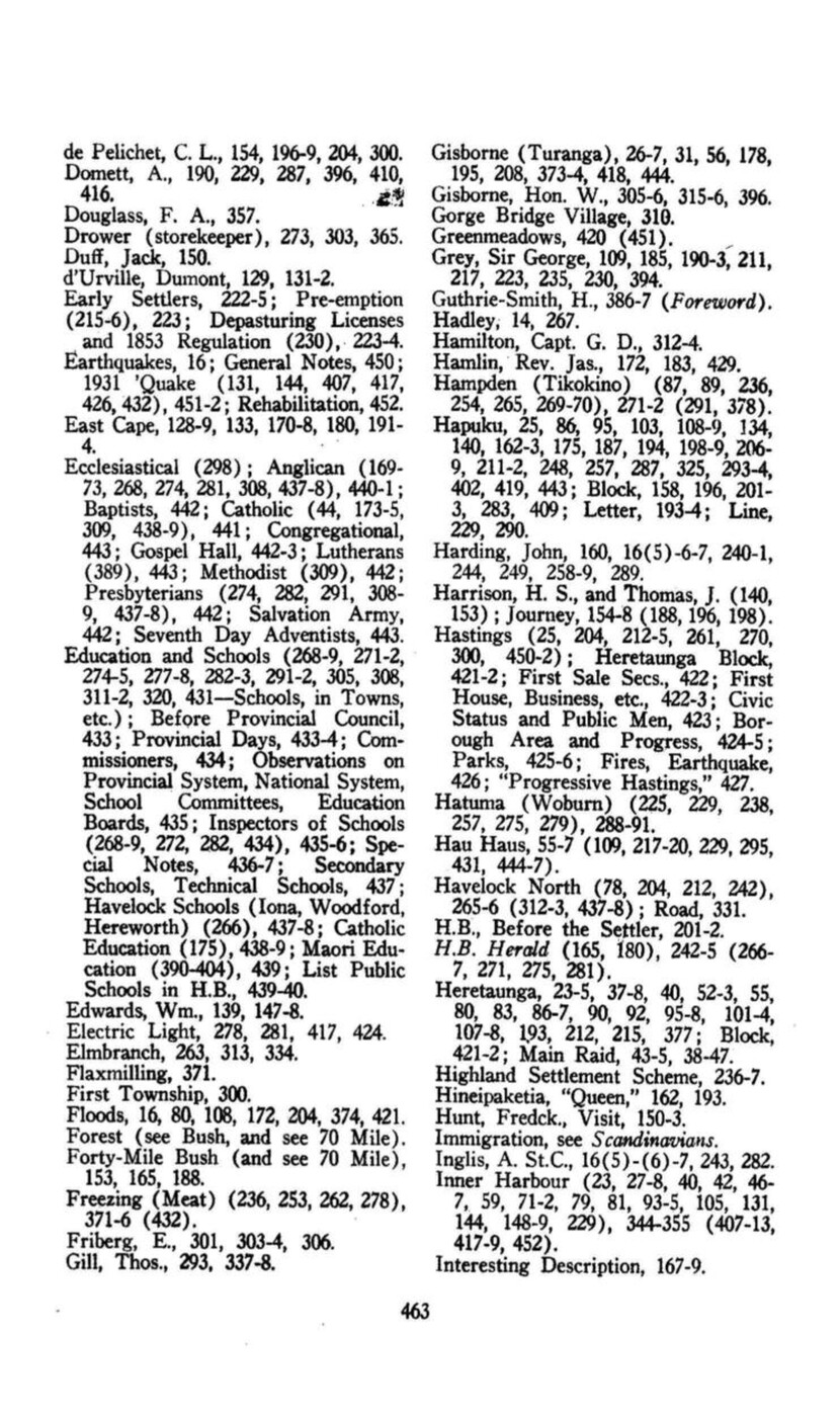
Page 464
Introduction: Boundaries, Climate, 9; Structural and Soil, 9-10 (Mountains, etc.); Lakes, 11; Vegetation, 11-12; Fauna, pre-settlement, 12; Plants and Animals, by Natives and Changes, 12-13; Post-Settlement Changes, 13-16 (Clearing and Shallowing and Shingling Rivers), 13-4; Sowing and Weeds, Maori Cultivation, 14; Fauna – destr. Native, 14-5; Intr. European, 15; Drainage, Reclamation, Rivers Control (Floods) and Earthquakes, 16.
Iron Pot, 346, 351, 412-3.
Johnston, John, 16 (5)-7, 201, 282.
Johnston, Sydney, 282-3; Diaries, 260-2 (279-80, 343).
Kahuranaki, 25, 67, 228.
Karaitiana (Christian), 100, 108, 168, 209, 317, 402, 445, 447.
Karanema, 134, 196, 198, 264.
Karauria, 56, 445.
Kettle, C. H., Journey, 153-4 (157, 188).
Kidnappers, Cape (Matau-a-Maui), 26, 42, 70, 93, 97, 130, 136, 138-9, 143, 179, 407; Naming, 118, 120-2, 125; Fight, 280.
Lakes, 11, 451 (see Ruataniwha, Roto-a-Tara).
Land Purchase Troubles, 211-5; Illegal Leasing Native Lands, 212-3; Native Lands Act, 1862, 213-6 (275).
Locke, S. (219, 314), 315-6.
Maharahara, 311; Copper Mine, 378.
Mahia, 22, 26, 29, 31, 33-4, 47, 51, 66-7, 81, 83, 85, 92, 116, 131, 133, 135, 137, 147, 151, 154, 172, 174, 198, 279, 428-9, Chap. 85-98; near Te Hauke, 69; Township, 431.
Mails, 363-5; Lists, 363; Overland, 364, Steam Subsidy, 364; Inland services, 364-5. (See also Post Offices).
Manawatu, 101-4, 146, 150-1, 163-61, 166, 176-7, 188, 196, 261, 301, 312, 314, 325, 393; Blocks, 315-8; Road, 194, 331-3, 334; Village, 310.
Mangatoro (307), 312, 313-4.
Maps (151, 167), 202-4.
Marshall, William, 262, 412, 433-4.
Mataikona, 64, 154, 182-3.
McDonnell, Lieut., 132-3, 345, 407. Cove, 144-5, 299, 345.
McLean, Sir Donald, 38, 158, 193, 203, 213, 223, 225, 249, 299, 316, 326, 329, 382, 384, 409, 445; Biog., 386; Letters, 194-5, 204-5, 209-11, 217-8, 218-20, 222.
McKain, 163, 223, 298-300, 327, 408.
Medical and Doctors, 167, 207, 273, 275, 298, 309, 320, 361, 404, 414, 416, 430, 431-2.
Meeanee (175, 218, 238, 242, 275, 410, 414, 419), 420 (438-9, 441, 446).
Meredith, Edwin, 225, 275.
Milbourne Run (Argyll), 228, 291-2.
Military (56, 210-11, 216-21, 260-3, 271-4, 279-80, 294-5, 297-8, 362, 411-3), 443-8; Maori Wars, 443-7; Hau Haus, 444-7; Omarunui, 444-5; Te Kooti, 446-7; False Alarms and Presentations, 447; Volunteer Period, 447-8; Territorial, Boer War, Great War, Sir Andrew Russell, 448.
Missions, Missionaries (108, 139, 154-5, 163 (4); Ang., 169-73; Catholic, 173-5, 441 (325, 428-9, 433).
Mohaka, 46-7, 51-3, 81, 93, 105, 107, 133, 147, 157, 177, 184, 202, 236, 294, 409, 428, 446, 451-2; Block, 199; Blockhouse, 362.
More Early Visitors, 165.
Morris, Wm., 135-6, 139-40, 179.
Musical and Dramatic (Napier), 448.
Nairn, C. J. (125, 138, 235), 245-54 (262, 337).
Napier (50, 56-7, 66-7, 157, 300, 330, 343-5, 359-62, 363-5, 373, 441-5, 447-52), 407-19; Earliest Descriptions, 407; First Settlement, 407-8; Waipureku (Clive), 408; Ahuriri Block, 408-10; Mataruahou (Scinde Island), 410; First Sale Secs., 410-11; Westshore, 410-11; Mrs. Dunlop’s Narrative, 411-3; Pessimistic Description, 413; Main Lines Communication, 413-4; Awatoto, Lines of Development, 414-5; Clive, Provincial Days, Napier Borough, 415; First Council and Mayors, 415-6; Work of Council, 416; Reclamation, 416-7; Electr., and Theatre, Seaside Amenities, 417; Norfolk Pines and Parade, 417-8; Tourist Centre and General Progress, 418; Pukemokimoki, 418-9; Taradale and Greenmeadows, 419-20; Other Suburbs, 420.
Napier Harbour (see Port).
Page 465
Native Discontent, 207-11; Native Hostilities (Pakiaka), 207-8; King Movement (198), 208-11.
Native Lands Act, 1862, 213-6 (275).
Nelson, William (240, 253), 371-6, (378, 438, 450).
Newspapers, 269-70, 307-8, 311; The First, and Items, 242-4.
Ngaruroro (Plassey, Awapuni), 40, 44, 46, 70, 75, 78, 107, 157, 167-8, 204, 243, 275, 407, 413, 421; Bridge, 331.
Noah, 167-9.
Norsewood (and Dannevirke) (13, 161, 166, 177, 377, 378), 300-5; Scandinavian Immigration, 300-3; Settlers, 303-4; Other Settlements, Schools, 305.
Northwood, J. N., 165, 194-5, 200-1, 245-9, 257, 265.
Nuhaka, 133, 147, 174, 178, 432.
Omarunui (56-7, 109), 216-221 (229, 263, 295, 399, 414, 444-5).
Onepoto, 57, 103, 105, 148, 165, 179, 183, 408, 411-3, 443-4.
Ongaonga (269), 280-1.
Oringi, 150-3, 160-2, 303, 307, 313, 333.
Ormond, J. D., 204, 215, 236, 238, 243, 245, 262, 313, 315-8, 352, 382, 384-5, 415, 421, 434-5,; Mrs., 447.
Ormondville, 305, 310.
Otane (Kaikora) (270), 281-2, (291).
Pakiaka (fight), 108-9. 119, 199, 207.
Pakipaki, 37, 61-2, 77-8, 187, 261, 375.
Pakowhai, 34, 62, 85, 99, 102, 107, 162, 174, 257.
Parimahu, 42, 155, 201.
Park, Robt., 153-4, 158, 194, 196-7, 201-2, 300, 409.
Parkinson, Sydney, 120-1, 123.
Patangata, 99, 101, 162, 197, 200, 244, 249-50, 252.
Patea (Inland), 85-6, 89-90, 104-5, 189, 236; Road, 324, 341-2, 364.
Patoka (Stockade), 293-4, 296-8.
Pa Whakairo, 56, 108, 218-9, 444.
Peep at the Past, 245-6.
Petane, 23, 41, 56, 59, 87, 90, 92, 105, 117, 163-4, 218-9, 221, 407, 444-6; and Westshore, 298-300.
Pharazyn, C. J., 132, 247; Diary, 254-8
Polack, 133-4 (428).
Poraiti, 148-9, 295, 313.
Porangahau (22-3, 42, 65, 90, 97, 155, 210, 221, 263-5), 270-1 (325, 335, 360); Block, 229, 290.
Port of Napier (Ahuriri), Early Days (59, 117, 140, 146, 148-9, 165, 172, 179, 199; of Entry, 243; 407, 413, 318), 344-51; Trade, 346; Sailing Days (168, 184, 194, 243), 346-7; First Steamer, 347; Wool Ships, 347-8; Passenger Ships, 348-9; Steamers and Services, Pilots, 349; Lightering, 349-50; Murray’s Log, 350; First Pass. Ser., 250-1; First Harb. Commssn., 251.
Napier Harbour, 351-5; Trade, 355.
Portland Id., 116, 120, 122, 125, 136.
Poukawa, 23, 37, 73-4, 77, 88, 99, 101, 162, 187, 199.
Pourerere (122), 246-54 (365, etc.).
Poverty Bay, 116, 135, 171, 180, 195, 444-6.
Provincial Government (146, 212-3, 264-6, 301, 313, 328, 337-8, 359-60, 415, 419, 430, 433-4), 380-5; Revenue, 380-1; Wellington Province, 381-2; General Assembly and Leg. Ccl., 384; Separation, 382-3; Council, 384; Superintendents, 384-5; Abolition Provinces, 285.
Pukekaihau, 84, 279-80, 443.
Puketai, 151-3, 160-1, 186, 325, 333, 393.
Puketapu (107), 297-8 (293-6).
Puketitiri (72); Road, Settlements on, 293-8.
Rabbits, 15, 257, 296.
Railway (261, 277, 283, 304, 306, 335), 342-4 (418, 423, 452).
Rangitikei, 158-9, 186, 188-9.
Rats, native, 27, 190.
Rauparaha, 151-2, 156.
Reclamation, 16, 144, 398, 416-8, 452.
Renata Kawepo, 101, 108, 148-9, 209, 220, 324, 394, 445.
Rhodes, J., 146, 242, 244, 246, 265, 382-4.
Rhodes, W. B., 141-6 (165, 345, 407, 428).
Rich, Geo., 199-201, 223, 249, 292, 329, 429.
Rissington (Pekapeka) (77, 146, 229), 295-7.
Rivers and Control, 10, 13, 14, 16, 167, 374.
Page 466
Roads (210, 267, 293, 320, 413-4, 419), 324-38; Main Maori Tracks (161, 166), 324-5; Taupo Track (293, 361-2, 364, 418), 325-9; Cooper’s Report, 326-8; Select Committee, Sam. Graham’s Trip, and Bold’s Report, 328; Napier-Wairoa, 329-30 (418, 430); Coastal Track, 330; Main Highway (161, 166, 177, 194, 303, 397), 331; Seventy-Mile Bush Road (194, 204, 262-3, 313), 331-3 (Agreement, 332-3); Roads and Hotels, Southern H.B., 333-4; Manawatu Gorge Road, 334; First Public Body – Road Wardens, 334-5; Waipukurau-Takapau, 335-6; C. H. Weber, 336-7; Blackhead road, 337; First report, Gill, Prov. Engineer, 337-8.
Rochfort, J., Visit, 158-64 (167, 198).
Roto-a-Tara, 16, 23, 52-3 (Chap. 53-5), 66, 69, 85, 86-9, 91-2, 94, 98-9, 100-3, 107, 148, 177, 185, 187-8, 393, 398-9.
Ruahine, 28, 64-5, 72, 75, 78-80, 84, 86-91, 99, 107, 146, 155, 159, 186-90, 197, 202, 204, 216, 236-7, 273, 314.
Ruataniwha (Lindsay sttmt. And Plains) (161-7, 177, 187, 199, 200-2, 210, 223, 236, 239, 244, 250, 259-61, 267, 273, 282), 292 (332-3, 335, 443).
Russell, 165, 173, 220, 445; H. R., 225, 228 (Mrs., 258), 260, 274-6, 280, 359, 394-6; Purvis 215, 235, 242-3, 247, 257, 289-90, 330, 382, 396-7, 421; Sir Andrew, 387 (448); Sir Wm., 215, 298, 421.
Sawmilling, see Timber.
Scandinavians, 300-310 (321-23, 335); Settlement before in Southern H.B., 312-4.
Schools, see Education.
Scinde Id. (Mataruahou) (118, 130, 407, 409), 410.
Selwyn, Bishop (137, 154, 164, 172), 175-9 (190, 393, 429, 441); Stone, 178-9.
Settlement Along the Hills, 236-8.
Settlers, Early – See Early Settlers.
Seventy-Mile Bush, 11-13, 37, 88, 194, 204, 262, 333; Block – Correspondence and Purchase, 315-8. (See also Roads.)
Sheep, Breeds, 200, 246, 252-3, 261, 297, 375; Prices, 235, 252-3, 261-2, 395; Inspectors’ Reports, 234-5; Returns, 231-4; Scab, 234, 238, 430; Machine shearing, 262.
Shipping (see Port), Building, 271.
Shipwrecks, 356-8.
Soldiers (see Military), Settlement Scheme, 1868-9, 237-8.
Southern H.B., Roads and Hotels, 333-4; Settmt. Before Scandinavians, 312-4.
Speedy Bros., 222-3, 257.
Sports, 200, 210, 333, 403-4, 448-50.
Squatter, 128-242; Subdivision and Passing Reign, 238-9; Conditions, Living, 239-40; Anecdotes, 240-2.
Stafford, Prime Minister, 217, 220-1.
Stokes, J. M., and R., 228, 291-2.
Stories, 388-9.
Subdivision, Notes on, 238.
Table Cape, 116, 125, 143-4, 151-4, 157.
Tahoraiti, 153, 262-3, 303, 313, 318, 334.
Takapau (91, 260-3), 282-4 (444); Road, 335-6; Sawmilling, 374, 378.
Tangoio, 39, 48-9, 69-70, 81, 102-3, 139-40, 148, 312-8.
Taradale, 419-20 (414, 451).
Tarawera, 50-6, 94, 103, 108, 189, 219, 327, 361-2.
Tareha, 56, 95, 104, 108, 187, 209, 220, 287, 402, 414, 445.
Taupo, 28, 45-6, 50-1, 54-6, 78, 87-8, 90-2, 95-6, 101-4, 108, 157, 172, 189, 236, 263, 279, 293, 325, 340-1, 361-2, 364, 401, 444.
Tautane (155, 183, 200, 204, 260), 270.
Taxation, Local, 1855, 379.
Te Aute (37, 88-9, 185, 208, 212, 235, 239, 291, 330-1, 412-3), 390-404; Introduction, 390; Samuel Williams, 390-2; Te Aute, 392; Genesis College, 392-6; Native Donors, 394; Commission, 1861, H. R. Russell’s Report, 394-5; First Trustees, 395; Lease, 395-6; Commission, 1869, 396-7; Genl. Progress, 397-8; Drainage L. Roto-o-Tara, 389-9; Last Commission, 299-402 (Native Donation, Trustees, Witnesses, Result); Native Township (Milltown), 402; Death Saml. Williams, 402; Recent, 402-3; Distgshd. Old Boys, 403-4.
Page 467
Te Haroto, 55, 89, 236, 362.
Te Hauke, 69, 71, 73, 77, 107, 109, 198-9, 208.
Te Kooti, 55, 229, 239, 263, 279, 432, 443-5.
Telegraph, 359-62; Napier-Wellington, 359-60; The Line, 360-1 (Roythorne); Napier-Taupo, 361-2; Blockhouses, 362.
Te Moananui, 95, 101-2, 104, 108-9, 187, 199, 207-8, 211-2, 411, 443.
Te Pohue (22, 189, 218-20), 298 (327, 452).
Te Rangihiroa, 57, 219-21, 445.
Te Uri, 318-21; Early Visit, 321-3.
Te Whiti clearing, 161, 176, 333.
Thomas, J. – See Harrison.
Tiffen, Nairn, and Pourerere, 245-54; Fred Tiffen (165, 194-7, 245-54, 299), 246-7 (H.S., 198, 200-1, 235, 238, 242, 245-54, 265, 281, 419);
Tiffen’s A/c. Book, 247; C. J. Nairn, 248-9; Tiffen, Ctl. H.B., 249; A/c. Book, contin. (Wool 249-52; Sheep, 522-3; Cattle, 253-4); Fin. Notes F. Tiffen, 254.
Tikokino – See Hampden.
Timber, 75, 96, 145, 196, 201-2, 216, 230, 254, 272, 284-5, 294, 306-7, 310, 374, 377-8.
Tolaga Bay, 29, 123, 129, 131-4, 191.
Tomoana, Captain Henare, 108, 447. Freezing Works, 373-6, 427.
Totoapua, 289.
Trade, Traders, 98, 131, 133-4, 141-6, 148-9, 150, 163, 168, 170, 184, 192, 298-300, 408, 411, 428-30, 346, 355, Chap. 368-70; Early Trade, 368-9; First Export Wool, 369; Inward Cargo, 369-70; Customs, 370.
Tuki Tuki (Alma), 46, 61, 78, 91, 101, 123, 140, 146, 156-7, 167, 185, 201-2, 211, 225, 236, 249, 259, 275, 279, 288-90 330, 407.
Turnagain, C., 121-2, 125, 130, 155, 203.
Tutaekuri (Miani), 23, 27, 42, 74, 75, 79, 80-1, 107-8, 117, 123, 148, 218, 221, 275, 294, 298-9, 352, 407, 419.
Twelve Apostles, 215-6.
Waiapu, 83, 171, 178, 182, 440-1.
Waikato, 28, 51, 89, 93-5, 97-8, 106, 141, 146, 172, 183, 208-9, 279, 325, 401.
Waikokopu, 116, 135-7.
Waipawa (Abbottsford) (175, 331, 335-6, 359-60, 363-6), 266-70; Beginnings, 266-7; Rivalry Waipuk., 267; Courthouse, 267-8; Progress, Church, 268; School, 268-9; First White Woman, 269; Exhibition, 269-70; River, 177, 187, 189, 201-2, 236.
Waipukurau, 65, 84, 107, 173, 199-200, 202, 223-5, 243, 259-61, 266-8, 335-6, 359-60, 363-6, 374, 443, 272-80; Early, 272-3, First Buildings, etc., 273; Military, 273-4; H. R. Russell’s Model Village, 274-5; Police, Courthouse, 275-6; Early Celebration, Residents, 276; Opening Rly. Stn., 277; School, 277-8; Frzng. Works, Civic Status and Public Bodies and Work and Progress, First Auct. Sale, 278; Notable Visitor, 278-9; Pukekaihau, 279-80.
Wairarapa, 11, 12, 24-6, 36, 63-4, 91, 125, 129, 133-4, 166, 190, 192-45, 205, 221-2, 246-8, 254-8, 263, 279, 315, 331-3.
Wairoa (22-3, 33-7, 43, 66-8, 79-80, 95, 97, 100, 102, 105, 133-6, 166-7, 172, 174, 178, 300, 329-30, 377, 4518, 438-9, 444-7, 451-2), 428-32; Beginnings, 428; Missns., 428-9; Traders, 429; Settlers, 430; Township, 431; Public Bodies, 431-2; Railway Gen. Development, Earthquake, 432.
Wakarara (9, 236, 401), and Kereru, 284-8; W., 284-5; K., 285-6; Smiths Olrig, 286-7; Maori Relics, 287; Capture Ellis, 287-8.
Wallingford (Eparaima), 270-2, 335, 337.
W(h)anganui, 155, 157-8, 235, 262-3, 401.
Weber, C. H., and Town (271), 336-7 (352, 364).
Wellington (Harbour, Provincial Council, and Port Nicholson), 24-6, 47, 143, 145-6, 192, 224-5, 230, 255, 381-2.
Westshore (346, 351, 375, 408, 410-1, 419-20); and Petane, 298-300.
Whakaari (39, 42-3, 102, 135), 139-40.
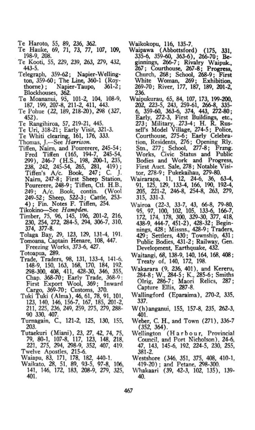
Page 468
Whakatu (108, 162, 193, 199, 208), 375-6 (443).
Whalers, Whaling, 135-9 (154, 156-7, 168, 180, 184-5, 192, 299, 369, 428, 430; Ship, earliest recorded visit to N.Z., 126-9.
Wharerangi, 95-6, 100, 107, 148-9, 414.
Wheat growing, 14, 168, 195, 299, 369.
Whitmore, Sir George (215, 218-20, 229, 234, 276), 294-8 (312, 443-6).
Williams (Henry, William, W.L.), 169-72, 175, 177-8, 180-3, 258, 390-1, 428-9, 441; Archd. Samuel (158, 185, 215-9, 225, 235, 239, 246, 386, 441, 444), 390-404.
Wing, Capt., Survey, 133, 407.
Woodthorpe, 298.
Woodville and District (164, 178, 269, 374, 377), 310-2; Ballance and Ngawapurua Bridges, 312.
Wool Market (and Ebb and Flow of Settmt.), 235-6; Prices, 249-52; First Drayload, 330; Export, 369; Store, 148; Ships, 347-8.;
LISTS.
Ahuriri names on Wellington Roll, 1853, 225.
Boundaries of – procld., Gazette, 1856, 231.
Crown Purchases, 205-7.
Electoral Roll for July, 1856, 231.
Export Figures, and Exports and Imports, 370.
Lands disposed by Natives, 1862-74, 213-5.
Land sold Ahuriri by Wellington Prov. Council, 1853-4, 224-5.
Mails, 363.
Mayors, Hastings, 423; Napier, 415-6.
Petition re land tenure, 1855, 230-1.
Post Office Returns, 366.
Rhodes’ Purchase, 143-4.
Runs and Runholders, 225-9.
Schools, Native Primary, 439; Provincial Days, 433-4; Public in Board District, 439-40; Spcl. Notes, 436-7.
Sheepfarmers, H.B., and numbers flocks, 1856, 245.
Sheep Returns, 1872, 231-4
Shipwrecks, 356-8.
Stock Returns, First, 229-31.
Superintendents, H.B. Prov., 384-5.
Surveyors before 1860, 198.
Te Aute, distinguished old boys, 403-4.
Trade, Port of Napier, 355.
Wairarapa Runholders, Wakefield’s Handbook, 1848, 222.
Wairarapa Settlers, 246-7.
Witnesses, Hapuku Block, 197-9.
Wool Market, 235.
Wool Prices, 251.
GENEALOGICAL KEY TO MAORI SECTION. +++
TOI alias KAIRAKAU
Rongoueroa
Whatonga
Tara
Rangitane
Awanui-a-Rangi
Hingunui-a-Rangi
Rauru
Miru
Rere
Tata
Tato
Rongokako
TAMATEA
KAHUNGUNU
Kahukuranui
Rakaihikuroa
TARAIA=Hinepare
Te Rangitaumaha
TE HUHUTI=WHATUIAPITI
Te Wawahanga-o-te Rangi
HIKAWERA II
Tuku-o-te Rangi
Numiaiterangi
Te Rangikoianake
Hawea
Tutura-o-te-Rangi
Te Rangikamangungu
Te Ua te Awha
Te Kauru
Hineiaia
Te Heipora
Karanema te Nahu
Arihi te Nahu
Mepera Maku
Hori Tupaea
Ehau Tupaea
Te Hauwaho
Te Ringatuhi
Wi Ngamaiaia
One One
Te Wiki Tahutahu
Kaururia=Haromi
Iraia Kaurauria
Rii Karauria
Arini Tonore
Maud A. T. Perry
Pani Kaurauria
Ruonihia
Whitiwhiti Hauwaho
Tuhitio Hauwaho
Tuiri
Tareha te Moananui
Te Roera Tareha
Kurupo Tareha
Keko
TARAIA II=Punakiao
Hinemanu
Te Ngahoa
Tukokoki
Pakake
Tarahe=Te Nawe
Ruaiti
Taneuma (1st wife)
Piko
Te Hianga
Kato
Noa Huke
one Karaka
Tuterangi Moepo (2nd wife)
Te Hirangi=Hineiao
Tumanokia=Paka Paka
Renata Kawepo
Erena
Haromi=Karauria
Airini Tonore (and others)
Maud A. T. Perry
Hinehe=Whiuwhiu Hoia
Hetariki Ngarangi
Atareta
Harata
Harata=Alexander
Raiha Keokeo=Burnett
L. Harata Hine te Aho=Sir Charles Statham +++
Maata Kato
Peke
Rameka=Mangaone
Ruiha
Hiraka
Rora
Mapeka
Nohoke (3rd wife)
Ngunguru
Rewi te Uru
Wiari Turoa
Raruraru=Te Kikiri II
Paerikiriki
Naonao
Paramena
Tangatake
Erena Ngotukutuku
Pirika Toatoa
Te Kea
Mataora
Tauranga
Harata Ruaiti
Kohinui=Tangatake
Retapu
Wi Wheko
Kararauria
Paki
Hinemanu
Taorangi
Nikorioua
Meihana
Hori Taorangi
Wirihana Toatoa
Te Otene
Whenga
Pautama
Whitirangimaro
Kupe
Tukoroua
Heumea Taumata
Hingaoraroa
Tuteihanga
Rumakina
Kearoa
TURAUWHA=Kuratawhiti II
Tumahuki
Puketuna
Tamakanohi
Tataeata
Kaunino
Taukia
Te Matoe
Te Hinu=Te Ahuhu
Te Umurangi
Tamaiira=Hineterangi
Tamarakai=Te Mahue
Te Mahukihuki Wehi Hariata Tami Ana te Here Ihakara Timu Ihakara Nohomoke
Te Mu
Pahau
Rakai te Kura=Rangituehu
Hineiao
Huhuti Te Ruatiti Te Maniriti-a-Toe Parengeenge Taraia II HINE HORE Hineteko
Te Wawahanga o te Rangi
Te Rangitohumare Te Whakapakaru Takuterangi Kata Hinehore Kaipawe Hinetare Tamaki Tahanga
HIKAWERA=Te Uira I waho
Keko
Tuaka
Mahina-a-rangi
Kahu
Tuteaorere
Awatope
Maruiwi
Rakaumoana
Paritararoa
Tupouriao=Tuteihanga
Rumakina
Kearoa=Kuratawhiti I
TURAUWHA
Rakaipakaa

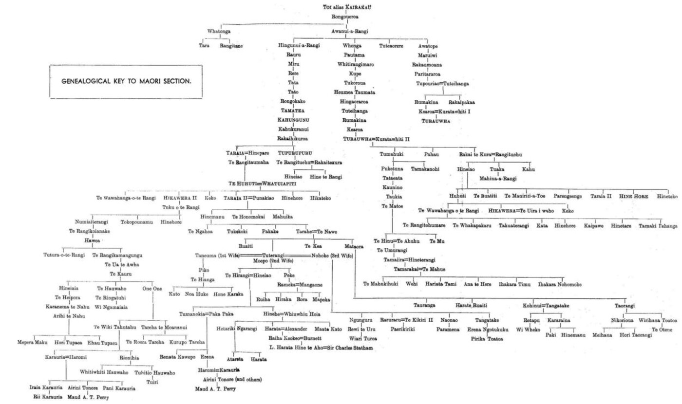
Original digital file
JacksonDL1302-4_HistoryOfHB.pdf
Non-commercial use

This work is licensed under a Attribution-NonCommercial 3.0 New Zealand (CC BY-NC 3.0 NZ).
Commercial Use
Please contact us for information about using this material commercially.Can you help?
The Hawke's Bay Knowledge Bank relies on donations to make this material available. Please consider making a donation towards preserving our local history.
Visit our donations page for more information.
Subjects
Tags
Format of the original
Book hardbackDate published
1939Accession number
623272Supporters and sponsors
We sincerely thank the following businesses and organisations for their support.


Do you know something about this record?
Please note we cannot verify the accuracy of any information posted by the community.