Magazine Article 2019 – Exploring Hawke’s Bay – Te Pohue
Exploring Hawke’s Bay: Te Pohue
Story by Bridget Freeman-Rock. Photos by Florence Charvin.
Before the old coach road was shifted further west in 1893, travelling from Napier to Te Pohue required 43 river crossings along the Esk River route. From Napier to Taupo was a three-day journey with overnight stops at Te Pohue, Tarawera and Rangitaiki.
By 1913 automobiles had replaced horse-drawn coaches, and Te Pohue Hotel provided luncheon (notified by carrier pigeon) on what was then down to an eight-hour haul, still hazardous, still steep, but increasingly busy, with up to six vehicles a day passing through!
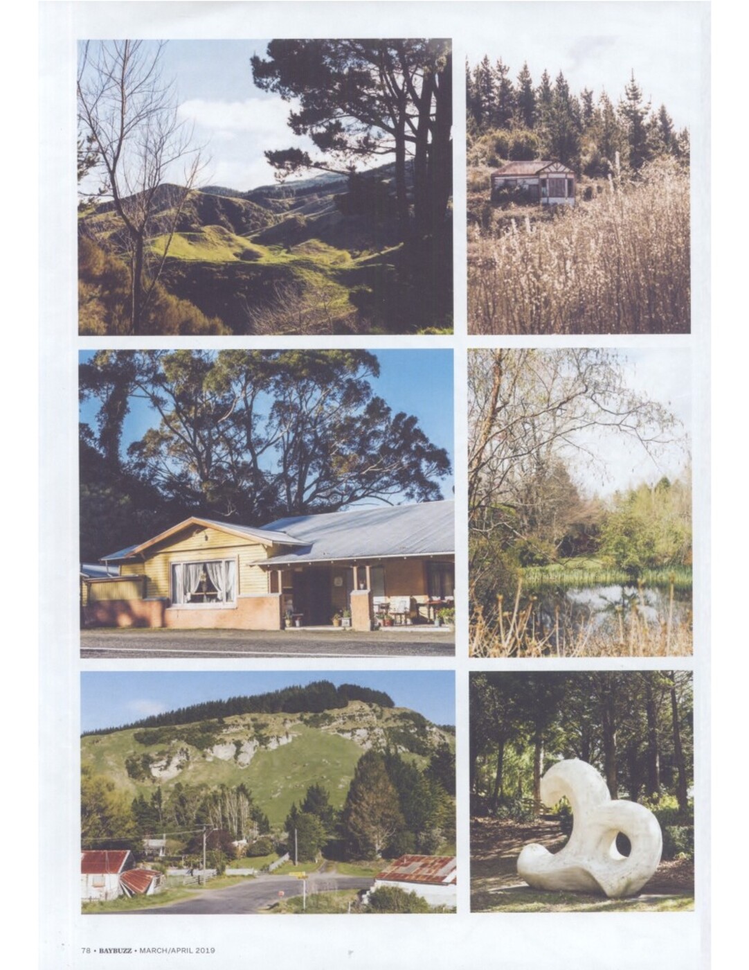
In the 1980s, Te Pohue was a rest stop by a lake with black swans before an arduous, invariably car-sick journey to the (now boarded-up) Summit Kiosk tea rooms by Turangakumu (halfway!) on the Napier-Taupo highway. In a 1980s childhood, Te Pohue was also the turn-off across farmland to Camp Te Waka, with its tremendous rocky outcrops, waterfall and mysterious, dense bush – a remnant of the vast red beech forest that once covered this area.
Now the lake (on private land) is set back behind willows, and Te Pohue is a smooth north-west curve on a wide sealed road through a panoramic sweep of rolling paddocks and various stages of plantation pine – from the cornbraid rows of baby trees to ravaged, clear-felled hills.
But it’s worth turning off the high-way for a moment to explore this hamlet nestled ‘in the shadow of Te Waka’ – the awesome ridgeline to the west that meets at the Titiokura pass with the Maungaharuru ranges in that dramatic run of road down to the vertiginous Mohaka Bridge and across up to Te Haroto and beyond to the highest point on the journey, Tupurupuru (908m).
Place of intrigue
For this is an area thrumming with ghosts and geological intrigue and an eventful storybook history – from famous rebels (Te Kooti) and celebrated writers (Sylvia Ashton-Warner, Katherine Mansfield), to infamy (bootleg grog, murder) and legend (moa bones and floating islands).
Te Pohue is located directly on an old Maori walking track from the interior of the island to the coast. A track taken by William Colenso in 1847, the first recorded European to do so, and upgraded to a road in 1869 by the Armed Constabulary when the Napier-Taupo route became strategically important. Five garrisons were built along it in order to contain the Pai Marire movement for Maori self-determination, the so-called Hauhau or ‘native threat’.
When the Armed Constabulary built their stockade at Te Haroto, a major Ngati Hineuru village, they were after the resistance leader Te Kooti, who, it is said, was sheltered numerous times by the hapu right under their noses – he himself named their meeting house, Rongopai (peace).
In 1887 the bush at Te Haroto was described as: “full of large sound matai and rimu and white pine, with a beautiful luxuriant undergrowth, and here and there heavy clusters of white star-like flowers gleamed through the green foliage.”
By the turn of the 19th century it was a bustling timber town. Now that the forests have gone, it’s pared back to the marae and a cluster of homes, several old wooden houses abandoned to the bracken and long grass.
While Te Haroto and Titiokura each got a military blockhouse, Te Pohue got a pub, which burnt down in 1897. Its replacement blew down in a gale; the third collapsed in the 1931 earthquake; the one left standing has closed. It had better luck with its school, which is still going strong. Curiously no church or cemetery. In its heyday as the closest native source of timber to Napier, it was a thriving community – when the natural resource was exhausted, the place declined, along with the birdlife that had once been so prolific.
In pre-European times Te Pohue was occupied seasonally. Kereru were plentiful, as well as mutton birds (titi), and once upon a time, moa (an almost complete skeleton was found here in 1910). At the time of the Ahuriri land purchase in 1851, which opened up the area for European settlement, iwi had sought to reserve 500 acres of the Pohui Bush beside the lake as a bird-snaring ground (a condition neither formalised nor honoured).
With the bush cleared and much of the steep surrounding land, with its friable soils, poor for farming, Te Pohue pioneered radiata pine in the 1920s. Following torrential rains in the ’30s that led to severe erosion, Esk Forest was planted in 1948 to stabilise the hills. It’s one of our ex-state forests, owned now by Forest Enterprises under Pan Pac, and about four years away from ‘peaking’.
Before the Te Pohue golf course (established 1967, and famous for its browsing sheep on the fairway), look out for the Old Coach Road, which will take you 5km through Esk Forest to Trelinnoe Park, one of the largest private gardens in the southern hemisphere, with a huge collection of rare and exotic plants, totara topiary, stone cherubs, sculptures.
The land was ‘broken in’ for farming in the 1950s by the Wills brothers, the first tree planted in 1960. It’s for sale, but apparently still open to the public. For two hours we strolled the 12 hectares of landscaped gardens, following paths named ‘Walk of the South Wind’ and ‘Vale of Xanadu’ to Daffodil Fields and the Bridge of Reflection. We didn’t see a soul, though we heard the nearby sounds of forestry and farm dogs.
Sylvia Ashton-Warner, a pupil at Te Pohue school 100 years ago, sums up the sentiment of bygone days in her memoirs, written as John and Fiona Wills began planting their garden idyll: “Cars swoop through, soft-tyed [tyred] and swift, their drivers thinking of something else, not knowing the lost population; not seeing their faces when they stop for gas, not hearing the whispering voices. Not as I who have lived here do.”
CLOCKWISE FROM TOP: The view from State Highway 5 near Titiokura; Te Haroto; Trelinnoe Park, one of the largest private gardens in NZ; one of the many artworks at Trelinnoe Park; Te Pohue settlement beneath the Te Waka ranges; the former Te Pohue or ‘Lake View’ Hotel, now a private residence.
MARCH/APRIL 2019 BAYBUZZ 79

Original digital file
MA201903TePohue.pdf
Non-commercial use

This work is licensed under a Attribution-NonCommercial 3.0 New Zealand (CC BY-NC 3.0 NZ).
Commercial Use
Please contact us for information about using this material commercially.Can you help?
The Hawke's Bay Knowledge Bank relies on donations to make this material available. Please consider making a donation towards preserving our local history.
Visit our donations page for more information.
Subjects
Format of the original
Magazine articleDate published
March 2019Publisher
BayBuzzAcknowledgements
Published with permission of Bay Buzz
People
- Sylvia Ashton-Warner
- William Colenso
- Katherine Mansfield
- John Te Kooti
- John and Fiona Wills
Accession number
630060Supporters and sponsors
We sincerely thank the following businesses and organisations for their support.


Do you know something about this record?
Please note we cannot verify the accuracy of any information posted by the community.