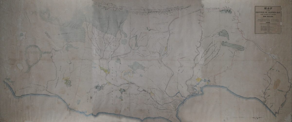
Map of the Province of Hawke’s Bay 1859
MAP
OF THE
PROVINCE OF HAWKE’S BAY,
(LATE DISTRICT OF AHURIRI)
NEW ZEALAND.
Compiled from the latest Surveys, and lithographed by C.M. IGGLESDEN and E. ANDERSON, Surveyors, Wellington.
1859.
NOTES.
Native Reserves are tinted YELLOW.
Land acquired by Government is edged with PINK.
Boundaries of Runs are dotted thus ___ . ___ . ___
Boundaries of Purchases are dotted thus – – – – –
Roads and Tracks are dotted thus ……………….
SCALE ½ [?] an inch to a mile.
Names/Locations
[NB only text that is easy to read has been included here – it will be updated if more information becomes available]
THE SEVENTY MILE BUSH
The Natives describe this by far the most eligible [?] of Road to Wairarapa
RIVER MANAWATU
OTARANGA BLOCK
About 50,000 Acres
J Alexander
J Williams
RUAHINE BLOCK
RUA TANIWHA
TR Russell
KW Russell
KE Tiffen
PORANGAHAU BLOCK
About 145,000 Acres
Native Reserve
2000 Acres
MARAEKAKAHO BLOCK
About 30,000 acres
Ormond
D McLean
HAPUKU BLOCK
E Collins
ROTO ATERA
Tanner
C Pharazyn
Poporangi
Clive River
Ngaruroro or Plassey
Domett
KAWEKA RANGE 2000 to 3000 [?] high
Mohaka River
Supposed course of the Mohaka
Waikare
J Chambers
G Moore
WAIMARAMA BLOCK
KIDNAPPER BLOCK
Rhodes
Awanga
MSE Hill
CLIVE
Waipureka
AORANGI
AHURIRI PLAINS
Lowry
Matapiro
A Alexander
PORT NAPIER
AHURIRI BLUFF
AHURIRI BLOCK
About 265,000 Acres
Villers
Cockburn
Ogilvy
Marshall
Blair
HB Sealy
Gray
Dyson
T Couper
PUKETITIRI BUSH
Imrie
Original digital file
GordonAJ1063_Map1859.jpg
Non-commercial use

This work is licensed under a Attribution-NonCommercial 3.0 New Zealand (CC BY-NC 3.0 NZ).
Commercial Use
Please contact us for information about using this material commercially.Can you help?
The Hawke's Bay Knowledge Bank relies on donations to make this material available. Please consider making a donation towards preserving our local history.
Visit our donations page for more information.
Description
Surnames in this map –
Alexander, Anderson, Awanga, Blair, Chambers, Cockburn, Collins, Couper, Domett, Dyson, Gray, Igglesden, Imrie, Lowry, Marshall, Matapiro, McLean, Moore, Ngaruroro, Ogilvy, Ormond, Pharazyn, Plassey, Poporangi, Rhodes, Russell, Sealy, Tanner, Tiffen, Villers, Waikare, Waipureka, Williams
Subjects
Tags
Format of the original
MapDate published
1859Accession number
1063/1392/38033Supporters and sponsors
We sincerely thank the following businesses and organisations for their support.


Do you know something about this record?
Please note we cannot verify the accuracy of any information posted by the community.