Newspaper Article 1988 – Napier pre-1931 Earthquake
Napier pre-1931 Earthquake
NIE
NEWSPAPERS IN EDUCATION
A Hawke’s Bay Herald-Tribune Educational Project
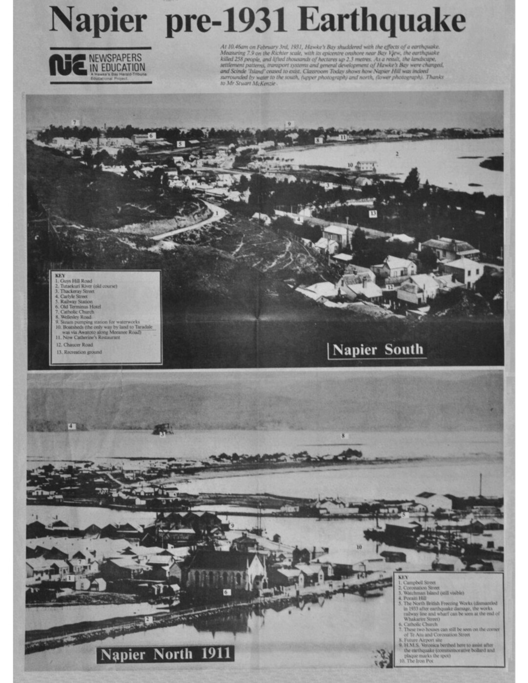
At 10.46am on February 3rd, 1931, Hawke’s Bay shuddered with the effects of a earthquake. Measuring 7.9 on the Richter scale, with its epicentre onshore near Bay View, the earthquake killed 258 people, and lifted thousands of hectares up 2.3 metres. As a result, the landscape settlement patterns, transport systems and general development of Hawke’s Bay were changed, and Scinde ‘Island’ ceased to exist. Classroom Today shows how Napier Hill was indeed surrounded by water to the south, (upper photograph) and north, (lower photograph). Thanks to Mr Stuart McKenzie.
Napier South
KEY
1. Guys Hill Road
2. Tutaekuri River (old course)
3. Thackeray Street
4. Carlyle Street
5. Railway Station
6. Old Terminus Hotel
7. Catholic Church
8. Wellesley Road
9. Steam pumping station for waterworks
10. Boatsheds (the only way by land to Taradale was via Awatoto along Meeanee Road)
11. Now Catherine’s Restaurant
12. Chaucer Road
13. Recreation ground
Napier North 1911
KEY
1. Campbell Street
2. Coronation Street
3. Watchman Island (still visible)
4. Poraiti Hill
5. The North British Freezing Works (dismantled in 1933 after earthquake damage, the works railway line and wharf can be seen at the end of Whakarire Street)
6. Catholic Church
7. These two houses can still be seen on the corner of Te Atu and Coronation Street
8. Future airport site
9. H.M.S. Veronica berthed here to assist after the earthquake (commemorative bollard and plaque marks the spot)
10. The Iron Pot

Napier – Post 1931 Earthquake
NIE
NEWSPAPERS IN EDUCATION
A Hawke’s Bay Herald-Tribune Educational Project.
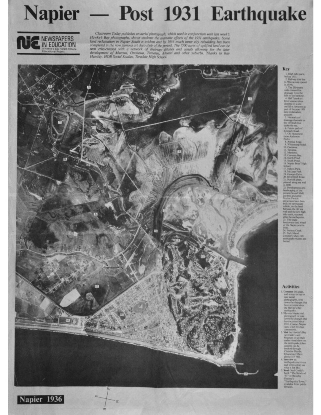
Classroom Today publishes an aerial photograph, which used in conjunction with last week’s Hawke’s Bay photographs, show students the dramatic effects of the 1931 earthquake. Some land reclamation in Napier South is evident and by 1936 much inner city rebuilding has been completed in the now famous art deco style of the period. The 7500 acres of uplifted land can be seen criss-crossed with a network of drainage ditches and canals allowing for the later development of Marewa, Onekawa, Tamatea, Ahuriri and other suburbs. Thanks to Ray Hambly, HOB [HOD – Head of Department] Social Studies, Taradale High School.
Napier 1936
Key
1. High tide mark, before 1931.
2. Railway (the line to Wairoa was opened in 1939).
3. The 250-metre wide channel for drainage from the hills to the harbour.
4. Old Tutaekuri River course (since diverted to a new outfall at Awatoto as part of the post 1931 land reclamation project).
5. Networks of drainage channels to dry off land once under the sea.
6. Future path of Kennedy Road.
7. Old racecourse (now Anderson Park).
8. Avenue Road.
9. Wharerangi Road.
10. Onekawa.
11. Tamatea.
12. Maraenui.
13. Corunna Bay.
14. North Pond.
15. South Pond.
16. Napier Boy’s High School.
17. Nelson Park.
18. McLean Park.
19. Georges Drive.
20. Riverbend Road.
21. Norfolk pines, planted along sea wall in 1890.
22. Development and landscaping of the present Sound Shell, gardens and other Marine Parade attractions have been built on earthquake rubble, on the land between the old sea wall and the new high tide mark, exposed after the earthquake.
23. The single breakwater and wharf of the Napier port in 1936.
24. Purimu Creek.
25. Park Island Cemetery where 101 earthquake victims are buried.
Activities
1. Compare this page, and a map (of up to date aerial photograph), note down the changes that have occurred since the Hawke’s Bay earthquake.
2. Fly over Napier and photograph or note down the changes that have occurred since 1931. Contact Napier Aero Club for class concessions.
3. Visit the Hawke’s Bay Art Gallery and Museum to see their audio-visual show on the earthquake (class sessions can be booked through Christine Hardie, Education Officer, phone 357 781).
4. Interview an earthquake survivors and write a story on what if felt like.
5. Read Geof [Geoff] Conly’s book “The Shock of ‘31” or Beverley Dunlop’s “Earthquake Town,” available from public libraries.

Original digital file
TobinJS662-6_Clippings_002-003.pdf
Non-commercial use

This work is licensed under a Attribution-NonCommercial 3.0 New Zealand (CC BY-NC 3.0 NZ).
Commercial Use
Copyright on this material is owned by Hawke's Bay Today and is not available for commercial use without their consent.Can you help?
The Hawke's Bay Knowledge Bank relies on donations to make this material available. Please consider making a donation towards preserving our local history.
Visit our donations page for more information.
Subjects
Format of the original
Newspaper articleDate published
3 and 9 February 1988Publisher
The Hawke's Bay Herald-TribuneAcknowledgements
Published with permission of Hawke's Bay Today
People
- Geoff Conly
- Beverly Dunlop
- Ray Hambly
- Christine Hardie
- Stuart McKenzie
Accession number
626248Supporters and sponsors
We sincerely thank the following businesses and organisations for their support.


Do you know something about this record?
Please note we cannot verify the accuracy of any information posted by the community.