Land gifted so track ran through it
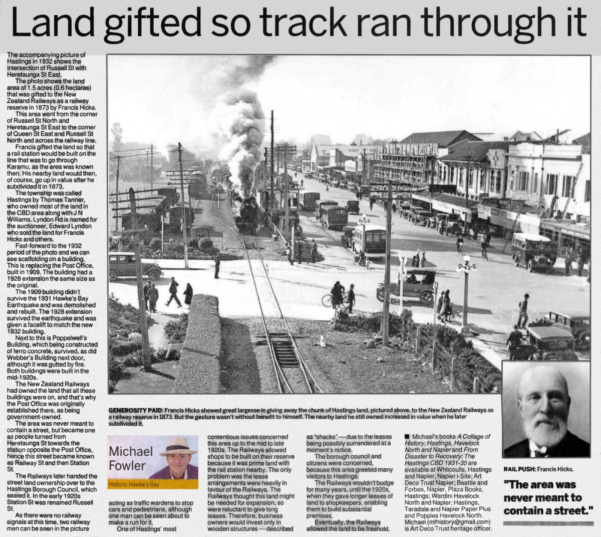
The accompanying picture of Hastings in 1932 shows the intersection of Russell St with Heretaunga St East.
The photo shows the land area of 1.5 acres (0.6 hectares) that was gifted to the New Zealand Railways as a railway reserve in 1873 by Francis Hicks.
This area went from the corner of Russell St North and Heretaunga St East to the corner of Queen St East and Russell St North and across the railway line.
Francis gifted the land so that a rail station would be built on the line that was to go through Karamu, as the area was known then. His nearby land would then, of course, go up in value after he subdivided it in 1873.
The township was called Hastings by Thomas Tanner who owned most of the land in the CBD area along with J N Williams. Lyndon Rd is named for the auctioneer, Edward Lyndon who sold the land for Francis Hicks and others.
Fast-forward to the 1932 period of the photo and we can see scaffolding on a building. This is replacing the Post Office, built in 1909. The building had a 1928 extension the same size as the original.
The 1909 building didn’t survive the 1931 Hawke’s Bay Earthquake and was demolished and rebuilt. The 1928 extension survived the earthquake and was given a facelift to match the new 1932 building.
Next to this is Poppelwell’s Building, which being constructed of ferro concrete, survived, as did Webber’s Building next door, although it was gutted by fire. Both buildings were built in the mid-1920s.
The New Zealand Railways had owned the land that all these buildings were on, and that’s why the Post Office was originally established there, as being government-owned.
The area was never meant to contain a street, but became one as people turned from Heretaunga St towards the station opposite the Post Office, hence this street became known as Railway St and then Station St.
The Railways later handed the street land ownership over to the Hastings Borough Council, which sealed it. In the early 1920s Station St was renamed Russell St.
As there were no railway signals at this time, two railway men can be seen in the picture acting as traffic wardens to stop cars and pedestrians, although one man can be seen about to make a run for it.
One of Hastings’ most contentious issues concerned this area up to the mid to late 1920s. The Railways allowed shops to be built on their reserve because it was prime land with the rail station nearby. The only problem was the lease arrangements were heavily in favour of the Railways. The Railways thought this land might be needed for expansion, so were reluctant to give long leases. Therefore, business owners would invest only in wooden structures—described as “shacks”—due to the leases being possibly surrendered at a moment’s notice.
The borough council and citizens were concerned, because this area greeted many visitors to Hastings.
The Railways wouldn’t budge for many years, until the 1920s, when they gave longer leases of land to shopkeepers, enabling them to build substantial premises.
Eventually, the Railways allowed the land to be freehold.
Michael’s books A Collage of History: Hastings, Havelock North and Napier and From Disaster to Recovery: The Hastings CBD 1931-35 are available at Whitcoulls, Hastings and Napier; Napier i-Site; Art Deco Trust Napier; Beattie and Forbes, Napier, Plaza Books Hastings; Wardini Havelock North and Napier; Hastings, Taradale and Napier Paper Plus and Poppies Havelock North. Michael ([email protected]) is Art Deco Trust heritage officer.
“The area was never meant to contain a street.”
Photo captions –
GENEROSITY PAID: Francis Hicks showed great largesse in giving away the chunk of Hastings land, pictured above, to the New Zealand Railways as a railway reserve in 1873. But the gesture wasn’t without benefit to himself. The nearby land he still owned increased in value when he later subdivided it.
RAIL PUSH: Francis Hicks.


Do you know something about this record?
Please note we cannot verify the accuracy of any information posted by the community.