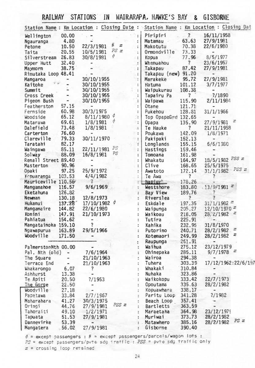
RAILWAY STATIONS IN WAIRARAPA, HAWKE’S BAY & GISBORNE
Station Name Km Location Closing Date
Wellington 00.00
Ngauranga 4.80
Petone 10.50 22/3/1981 # x
Taita 20.55 10/5/1981 PS x
Silverstream 26.83 30/8/1981 c
Upper Hutt 32.40
Maymorn 38.75
Rimutaka Loop 48.41
Mangaroa 30/10/1955
Kaitoke 30/10/1955
Summit 30/10/1955
Cross Creek 30/10/1955
Pigeon Bush 30/10/1955
Featherston 57.15
Fernside 60.98 30/3/1975
Woodside 65.12 8/11/1980 c
Matarawa 69.61 1/8/1981 c
Dalefield 73.48 1/8/1981
Carterton 76.60
Clareville 79.33 30/11/1970
Taratahi 82.17
Waingawa 85.11 22/11/1981 PS
Solway 88.09 16/8/1981 PS
Renall Street 89.40
Masterton 90.96
Opaki 97.25 25/9/1972
Kopuaranga 103.53 4/4/1982
Mauriceville 110.56 ?
Maungamohe 116.57 9/6/1969
Eketahuna 126.32
Newman 130.18 12/8/1973
Hukanui 137.28 17/10/1982 c
Mangamaire 144.82 22/6/1980
Konini 147.91 21/10/1973
Pahiatua 154.62
Mangatainoka 159.10 ?
Ngawapurua 163.89 29/5/1966
Woodville 171.50
PalmerstonNth 00.00
Pal Nth (old) 7/6/1964
The Square 21/10/1963
Terrace End 21/10/1963
Whakarongo 6.07 ?
Ashhurst 13.38
Te Apiti 20.50 ?/1953
The Gorge 22.50
Woodville 27.18
Papatawa 33.84 2/7/1967
Maharahara 41.27 30/3/1975
Oringi 44.76 27/9/1981 PSS x
Tahoraiti 49.10 1/2/1971
Tapuata 51.53 27/9/1981
Dannevirke 53.59
Mangatera 56.02 27/9/1981
Piripiri ? 16/11/1958
Matamau 63.68 27/9/1981
Makotutu [Makotuku] 70.38 22/6/1980
Ormondville 73.33
Kopua 77.96 8/5/1977
Whenuahou ? 23/6/1981
Takapau (new) 91.20
Marakeke [Maharakeke] 95.72 27/9/1981
Hatuma 101.12 3/7/1977
Waipukurau 108.38
Tapairu Pa ? ?/1890
Waipawa 115.90 2/11/1984
Otane 121.71
Pukehou 128.81 31/1/1966
Top Opapa Grd 132.65
Opapa 135.90 27/9/1981 x
Te Hauke ? 21/11/1958
Poukawa 142.09 1/8/1971
Pakipaki 152.13
Longlands 155.15 6/6/1980
Hastings 159.46
Tomoana 161.98
Whakatu 164.97 18/5/1982 PSS x
Clive 168.65 25/5/1975
Awatoto 172.14 31/1/1982 PSS x
Te Awa ? ?
Napier 178.26
Westshore 183.80 13/9/1981 x
Bay View 189.76 ?
Riverslea ? ?
Eskdale 197.35 31/1/1982 x
Waipunga 205.27 12/10/1980 x
Waikoau 218.05 28/2/1982 x
Tutira 225.91
Kahika 232.95 31/8/1970
Putorino 240.71 28/2/1982 x
Kotemaori 249.99 28/2/1982 x
Raupunga 261.91
Waihua 275.12 23/12/1970
Ohinepaka 285.11 9/7/1978 x
Wairoa 294.38
Tuhara 303.39 17/12/1962:22/6/1970
Whakaki 310.84
Nuhaka 323.63 28/2/1982
Kopuawhara 338.17
Paritu Loop 341.28 ?/1982
Beach Loop 357.41
Bartletts 363.59
Maraetaha 364.98 23/12/1979
Muriwai 373.73 28/2/1982
Matawhero 385.16 28/2/1982 PS x
Gisborne 390.40
c = except passengers # = except passengers/parcels/wagon lots
PS = except passengers/pvte sdg traffic PSS = pvte sdg traffic only
x = crossing loop retained.
24


Do you know something about this record?
Please note we cannot verify the accuracy of any information posted by the community.