State Highway 5 – Napier to Te Pohue
Transport time-line
1872: Ships arrive in Napier carrying Scandinavian migrants to settle in Dannevirke and Norsewood.
1878: Napier Gas Company supplies 36 street lamps, lit each night by a lamp lighter on horseback.
1880: Westshore Bridge built at a cost of £12,000 with a swing bridge at each end to allow ships to pass, and recesses at half-way point to allow pedestrians to stand aside when a herd of cattle comes through.
1882: Railway bridge opened over Tukituki River, with an excursion train running from Napier to Waipukurau.
1884: Dannevirke rail link established.
1889: Road bridge to Waipukurau over Tukituki River opened.
1895: New wharf and breakwater at Napier officially opened by Governor-General.
1913: First tram leaves Shakespeare Road for Ahuriri. Horse drawn vehicles now compete directly with trams and motorcars.

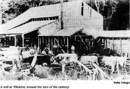
NATIVE SAWMILLS – A brief history along THE NAPIER TAUPO ROAD.
Forestry of one kind or another has always been a major contribution to New Zealand’s rural economy. Initially, the cutting of great indigenous forests of the North Island was regarded as a necessary operation in clearing land for family farms. The best of the timber could be salvaged and pit sawn for building purposes. What was left was simply burnt off in massive fires and the ashes were then seeded to grow pastures.
The scars of the burning, in the form of left-over logs, disfigured the hillsides until well into the twentieth century.
Though much of the Hawke’s Bay bush had been burnt in the days before the European, and even Maori, occupation, good stands of bush remained in the interior.
Hawke’s Bay was too far south for the majestic Kauri, but there were good supplies of Rimu, Totara, Matai, Red Beech, and Kahikatea on the Tarawera, Tataraakina and other inland blocks.
The milling of native timber began with the most accessible forests.
Around 1900, a sawmill was established to cut the native Te Pohue bush near the southern boundary of the Kaiwaka block on the Napier Taupo Road, and in combination with another sawmill at Lake Tutira, they produced in excess of one million feet of sawn timber a year. The Te Pohue sawmill closed in 1921.
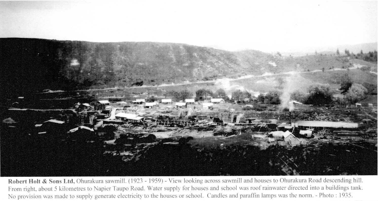
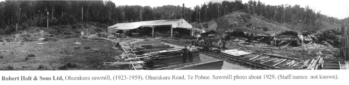
Robert Holt & Sons in 1923 purchased the Ohurakura native block 28miles (45Kms) from Napier – near Te Pohue and established a sawmill. In its latter years of operation logs were carted from Runanga Block – Rangitaiki Plains. The sawmill closed in 1959.
George Gardner & Sons, King Country sawmilling operations were coming to a close.
In 1927 the company purchased a large native block of bush at Te Haroto, 42 miles (68Kms) from Napier on the top of the Turangakumu Range, but it was not until 1935 before they established a sawmill and started cutting. In 1937 the company obtained cutting rights over a native block at the base of Turangakumu Hill (Waipunga Valley) and established another sawmill, calling it Tarawera Timber Co, – the sawmill was rebuilt after a fire in 1953. The mills became known as Gardner’s Top mill, and Bottom mill. Both mills closed in 1963.
Tuck Bros Ltd, native sawmill – Tataraakina Timber Co, Tarawera, 52 miles (84Kms) from Napier. Established a large modern sawmill, the last native sawmill to be built in NZ. Commenced cutting in1948. Selective logging was carried out in the Tataraakina block.
Sold to Fletcher Timber Co in 1960, the sawmill cut out the Tataraakina bush and closed, December 1966.
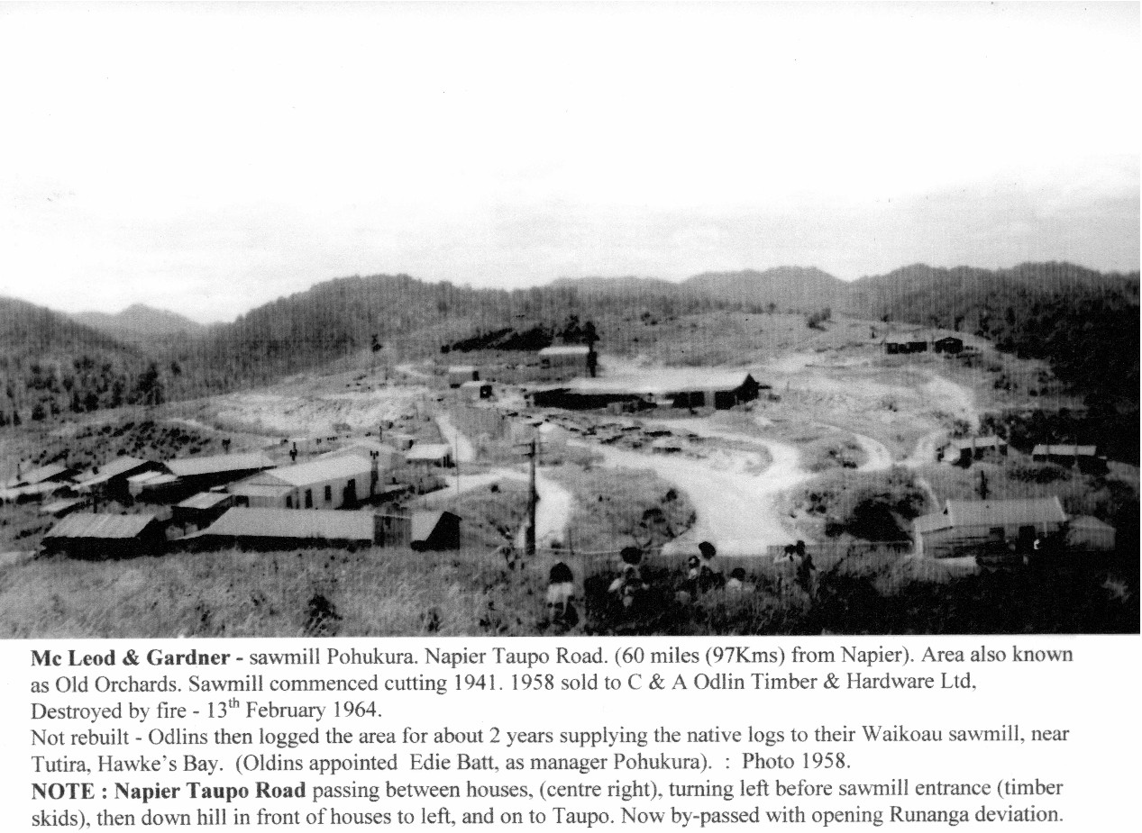
McLeod & Gardner Ltd, native sawmill, – Pohokura Timber Co (No connection to the Te Haroto Gardner’s) commenced sawmilling in 1941, at Pohokura. (also known as Old Orchards), 61miles (98kms) from Napier.
During 1958 McLeod & Gardner sold to C & A Odlin Timber & Hardware Ltd.
The sawmill was destroyed by fire, on the night of 13th February 1964, it was not rebuilt, but logging was continued from the Pohokura bush for approximately the next 2 years. The logging contractors, F.G Ware Ltd, then later Odlin’s, carting 118 miles (190 Kms) to Odlin’s Waikoau sawmill, near Lake Tutira, Hawke’s Bay.
Exotic forests – Pinus Radiata tree – approximately a 28 year cycle or (Crop).
Much planting took place in New Zealand during the depression years of the early 1930’s.
In the central North Island, the Kaingaroa Forest, the largest man made forest in the Southern Hemisphere spreads through to the Rangitaiki Plains on the Napier Taupo Road.
As early as 1924 at Te Pohue, on Rukumoana farm a small experimental block of Pinus Radiata was planted. In 1950 large plantings took place creating Rukumoana Forest of approximately 3,000 acres.
From the mid 1960’s onwards, ongoing plantings have taken place along many areas off the Napier Taupo Road. These forest areas of Radiata Pine are logged mainly, to supply the Napier Whirinaki Mill, and log exports through Napier Port, creating important overseas earning for New Zealand.
(Mileages (Kms) measured along the Old Napier Taupo Road).
Michael Palmer Tuck. May 2014.
Robert Holt & Sons Ltd, Ohurakura, – 5 kilometres down the Ohurakura Road. opposite the Te Pohue Golf links. 1,250 feet above sea level. (381 meters). – 28 miles (45 kilometres) from Napier.
Commenced cutting 1923. In the latter years were drawing native logs from the Runanga block. on the Rangitaiki Plains. Sawmill closed. 1959. Photo taken from Ohurakura Road. 1935.
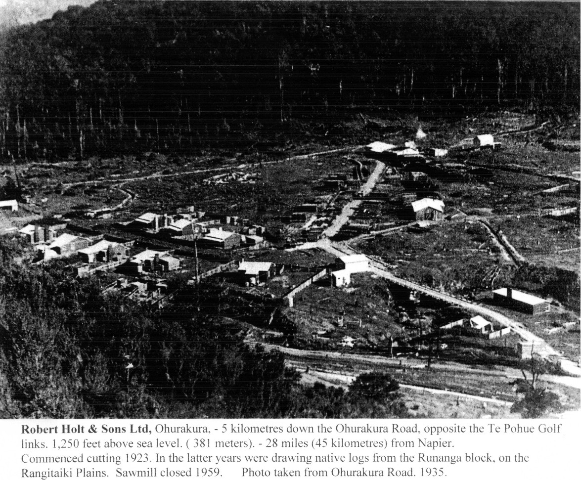
Robert Holt & Sons Ltd, Ohurakura sawmill. (1923 – 1959) – View looking across sawmill and houses to Ohurakura Road descending hill. From right, about 5 kilometres to Napier Taupo Road. Water supply for houses and school was roof rainwater directed into a buildings tank. No provision was made to supply generate electricity to the houses or school. Candles and paraffin lamps was the norm. – Photo: 1935.

George Gardner & Sons Ltd, Te Haroto, Napier Taupo Road. – Also known as “Top Mill”. Te Haroto 2,150 feet above sea level. (656 meters). 42 miles (68 kilometres) from Napier.
Sawmill commenced cutting 1935. Closed 1963 – bush cutout.
Southerly view from near to the Summit Kiosk tearooms, (moved to this site 1961- road deviation).
Photo: K & J Smith, Te Haroto school teachers 1958.

Tuck Bros Ltd, sawmill – Tataraakina Timber Co, Tarawera. Napier Taupo Road. 1,375 feet above sea level. (420 meters). – 52 miles (84 Kilometres) from Napier.
Sawmill commenced cutting 20th November 1948.
Selective logging was carried out in the Tataraakina bush block.
This sawmill was the last big native sawmill to be built in New Zealand.
Sold to Fletcher Timber Co, June 1960. – Bush cut out, sawmill closed 20th. December 1966.
Photo taken from the old Napier Taupo Road. 1955. Note school in foreground.

McLeod & Gardner – sawmill Pohukura [Pohokura]. Napier Taupo Road. (60 miles (97Kms) from Napier). Area also known as Old Orchards. Sawmill commenced cutting 1941. 1958 sold to C & A Odlin Timber & Hardware Ltd.
Destroyed by fire – 13th February 1964.
Not rebuilt – Odlins then logged the area for about 2 years supplying the native logs to their Waikoau sawmill, near Tutira, Hawke’s Bay. (Oldins [Odlins] appointed Edie [Eddie] Batt, as manager Pohukura). : Photo 1958.
NOTE: Napier Taupo Road passing between houses, (centre right), turning left before sawmill entrance (timber skids), then down hill in front of houses to left, and on to Taupo. Now by-passed with opening Runanga deviation.

Radiata Pine sawmilling & log export – Napier Taupo Road.
In the 1950’s New Zealand’s large Radiata Pine forests, planted mainly during the depression years were coming into maturity. There was very little planning for their ultimate use. A battle ensued with government departments to get radiata pine timber accepted and conserve our native timbers.
Tuck Bros Ltd, in 1951 pioneered the way by obtained [obtaining] the harvesting rights to the 25 thousand acres. (10.000 hectares) Tauhara Radiata Pine Forest, on Broadlands Road, near Taupo.
Stan Tuck. Managing Director Tuck Bros Ltd, designed and built a modern sawmill on the company’s property, Tauhara Road Taupo. The sawmill was named Tuck Bros (Exotics) Ltd.
This was New Zealand’s first, privately owned sawmill, purpose built with special machinery to handle radiata pine logs with speed and minimal man power. High grade timber was planer gauged to ensure uniform size with chamfered corners for safer and ease of handling. The timber was available in either Boric or Tanilith treatments according to required durability and end use.
The company established two pre-cut house factories at Taupo and Napier to manufacture Tuck Bros Pre- Cut Homes using pine timber. In the 1950’s it was extremely difficult to get planer gauged treated radiata pine accepted by Government Housing Department and local authorities. They still demanding [demanded] rough sawn native Rimu framing timber.
Two American built International LF 190 trucks were purchased by Tuck Bros Ltd, – 1951 / 52.
One carted timber over the Napier Taupo Road from the company’s sawmill to their retail timber yard at Corruna [Corunna] Bay, Napier. The International LF190 truck and trailer, built for rugged conditions, carted loads of approximately 12,000 feet of timber with ease over the old Napier Taupo Road. Travel time, approximately six and three quarter hours. This was the first truck to tow a four wheel flat deck trailer over this road. Government Transport Department bureaucracy had to be cleared first to allow this truck to tow a trailer.
LOG EXPORT Taupo Tauhara Pine Forest. Stan Tuck negotiated and exported from Tauranga port New Zealand’s first trial shipment of 158 tons (60,000 feet) of Radiata Pine logs to Toyo Menka Kaisha Ltd, Japan. Shipped on the “Tenwa Maru” sailing, 24th of November 1957.
From this trial shipment the New Zealand radiata log export trade started. The demand for logs was so great that Tuck Bros Ltd also exported through Napier port, starting on 20th June 1959 with an export contract to supply 100 million log feet to Japan’s fifth largest company, Toyo Menka Kaisha Ltd.
This created the strong case to Government to improve the Napier Taupo Road.
Stan died at his home, Greenmeadows, Napier on 11th October 1965 in his 60th year.
Stan’s vision was to commence the exporting of logs and then for the country to progress to building up infrastructure to add value to New Zealand’s radiata pine timber rather than just being an exporter of raw material. This would provide jobs/careers for New Zealanders.
Sadly 55 years on political and other considerations mean we are still largely an exporter of logs.
20/06/2013. M.P.T.

MILITARY POSTS ALONG THE NAPIER TAUPO ROAD : 1869 -1886.
MAORI WARS : THE HAU HAU WARS 1864 – 72.
(SOURCE: The NZ Wars: A History of the Maori Campaign and Pioneering Period: Volume II).
(Chapter 34) : Posts on the Taupo – Napier Road.
OPEPE- twelve miles (19 kilometres) from Taupo.
Te Kooti and his Hau Hau followers massacred 9 Armed Constabulary soldiers from the Bay of Plenty Regiment camped at Opepe on the 7th June 1869. The graves may be visited in off the Napier Taupo Road (sign posted).
1869 – 70 – Stockades built of strong timber were then established along the 100 mile (161 kilometre) length of the Napier Taupo Road.
Opepe stockade constructed in 1869 and maintained up to 1886, became a depot for the Armed Constabulary Field Force of up to 140 men and stabling for 50 horses. A large settlement grew up around the stockade and by the 1880’s Opepe had a population of about 600 people. The town had several shops, a licensed hotel, dance hall, and a race course.
RUNANGA – thirty six miles (58 kilometres) from Taupo. The Military Stockade was built on the hill at the edge of the bush overlooking the Waipunga and Runanga Streams and Falls. A sheep station was near by. The fort built in 1869 by the No 2 Division Armed Constabulary, under Sub-Inspector D. Scannell (formally of the 57th Regiment). Timber was hauled from the bush and the stockade was built after the Maori pattern, as there was no fern handy to bind the loose pumice soil into parapets. The palisade timbers were 10-11 feet high, with two horizontal rails inside lashed to the uprights with Aka-Vines and Kareao (supplejack) in the native manner. The main posts were large timbers, and saplings were set between them. Inside the stockade a trench was dug, and the earth was heaped up against the fence, which was loopholed at the ground-level. There were flanking bastions at two diagonally opposite angles of the works. One weak feature of the post was its distance from water.
TARAWERA – forty eight miles (77 Kilometres) from Taupo and 54 miles (87 kilometres) from Napier. The site is near the present hotel – (burnt to the ground July 1965) now site of Tarawera Café (2014). This strong stockade built in 1869 had a one story loopholed blockhouse in two angles; these blockhouses were constructed of thick logs, roofs as well as walls, for protection from bullets fired down from the higher hills.
TE HAROTO – fifty four miles from Taupo (87 kilometres) and 50 miles (80 kilometres) from Napier. (The Ngati-Hineuru Tribe). A blockhouse had been erected earliest [earlier] than the posts already mentioned, of 1869. This post was a square building with an upper storey projecting 2 – 3 feet over the lower building. A deep well was dug inside the blockhouse. The position was a commanding one, with a panorama of the mountainous country for many miles (kilometres) around. A mile away (1.609 kilometres) is the highest point on the Napier -Taupo Road, Tupurupuru 2,980 feet (909 meters) on the Turangakumu Range.

THE NEW ZEALAND WARS: A HISTORY OF THE MAORI CAMPAIGNS AND THE PIONEERING PERIOD: VOLUME II: THE HAUHAU WARS, (1864-72)
PAGE 514
(CHAPTER 34): POSTS ON THE NAPIER-TAUPO ROAD
When Armed Constabulary posts were established in the Taupo district in 1869 a number of fortified stations were erected to protect the line of communication with Napier across the plains and the lofty ranges intervening, a distance of nearly one hundred miles. At Opepe, twelve miles from Taupo, a strong timber stockade was constructed. At Runanga, about thirty-six miles from Taupo, a stockade was built on a hill overlooking the Waipunga and Runanga Streams. There was a sheep-station there. The fort was built in 1869 by No. 2 Division Armed Constabulary, under Sub-Inspector D. Scannell (formerly of the 57th Regiment). The Armed Constabulary hauled timber from the bush and built a stockade after the Maori pattern, as there was no fern handy to bind the loose pumice soil into parapets. The palisade timbers were 10 feet or 11 feet high, with two horizontal rails inside lashed to the uprights with aka-vines and kareao (supplejack) in the native manner. The main posts were large timbers, and saplings were set between them. Inside the stockade a trench was dug, and the earth and sods were heaped up against the fence, which was loopholed at the ground-level. There were flanking bastions at two diagonally opposite angles of the work. The one weak feature of the post was its distance from water. Its position was on the edge of the bush.
The next post was that at Tarawera (forty-eight miles from Taupo and fifty miles from Napier). The site is near the present hotel. This strong stockade had a one-storey loopholed blockhouse in two of the angles; these blockhouses were constructed of thick logs, roofs as well as walls, for protection from bullets fired from the higher hills.
At Te Haroto (fifty-four miles from Taupo), near the kainga of the Ngati-Hineuru Tribe, a blockhouse had been erected earlier than the posts already mentioned. This post was a square building with an upper storey projecting 2 feet or 3 feet over the lower. A deep well was dug inside the blockhouse. The position was a commanding one, with a panorama of the mountainous country for many miles around. A mile away is the highest point on the Taupo-Napier road, Tupurupuru (2,980 feet), on the Turangakumu Range.
At Titiokura, on the Maunga-haruru Range, a stockade was built in a prominent position, about 2,450 feet above sea-level, and about thirty miles from Napier.

NAPIER TAUPO ROAD TO WAIRAKEI. (State Highway 5).
State Highway 5. Starts/ends – Wairoa, Taupo road junction – Eskdale Valley).
Wairakei Hotel was a terminal for coaches and later buses. – Napier, Taupo, Wairakei. North bound passengers changed services travelling up the now steam valley, past Oruanui timber settlement, Hamilton, Auckland. – Eastern bound passengers Rotorua, Tauranga.
First ‘Coach Service’ to Taupo started 1872 by Mr. A. Peters. – Many ‘Transport Services’ were already established delivering supplies to Armed Constabulary, Construction Gangs, Hotels.
TRAVELLING TO TAUPO BY COACH SERVICE.
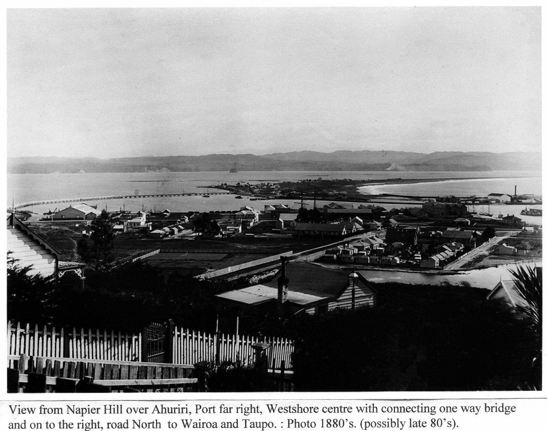
Early Ahuriri/Westshore : A regular ferry service ran between eastern and western spits.
Passengers for the 6 am Tuesday and Friday, Taupo Stage Coach Service crossed the estuary the night before, on the 7.30pm ferry. The ferry service could be delayed due to the weather. Passengers stayed at the Westshore Ferry Hotel.
The crossing itself was sometimes an unpleasant part of the journey for risks were run when horses were tied behind the boat and swam across. February 1874, horrified passengers watched helplessly while one of the swimming horses was attacked by sharks.
Leaving Ferry Hotel at 6am the journey took 2 days with an overnight stop at the Tarawera Hotel.
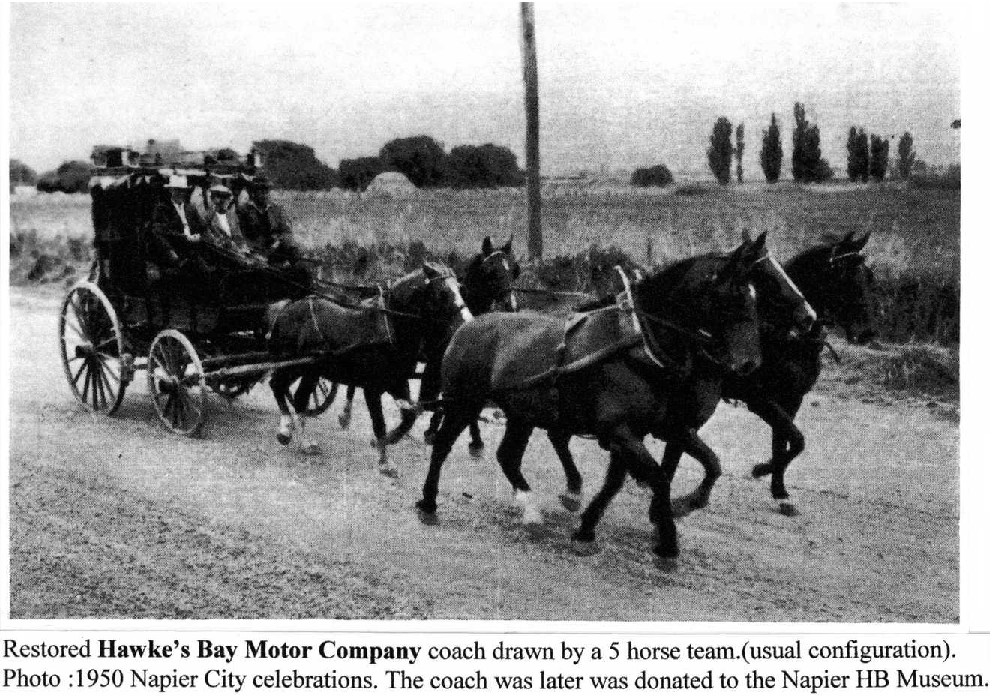
A Stage Coach on the Napier Taupo service, drawn by a team of 5 horses with 6 changes used 30 horses. Horses changed at Petane (Eskdale) Te Pohue, (Lunch) Mohaka, Tarawera, (Overnight).
Day 2 – Rangitaiki. (Lunch). Opepe, Taupo, Wairakei.
(References “Story of Napier 1874-1974. & One Hundred Years on the Napier Taupo Road, 1855- 1955.)
1880 : The Ferry hotel can be seen at the far end of the bridge. In pre bridge days this was the starting point for the coach service to Taupo.
The shingle spit stretching from centre to right is the route to Taupo.
FIRST NOTICE OF TAUPO COACH SERVICE, 1872.
“After the 1st of January 1872 Cobb and Co’s Telegraph line of Royal Mail Coaches will COMMENCE RUNNING on the Taupo Road, leaving Benker’s Ferry Hotel, Western Spit, every TUESDAY and FRIDAY Mornings early, returning on WEDNESDAY and SATURDAY.
Passengers and Parcels booked to the following places: PETANE, POHUE, TE HAROTO, TARAWERA, RUNUNGA [RUNANGA], OPEPE and TAUPO.
Intending Passengers for Taupo will please remember that a part of the Road has yet for a while to be performed on horseback.
Booking Office, Port Ahuriri: Borrough’s Commercial Hotel.
A. PETERS, Proprietor.

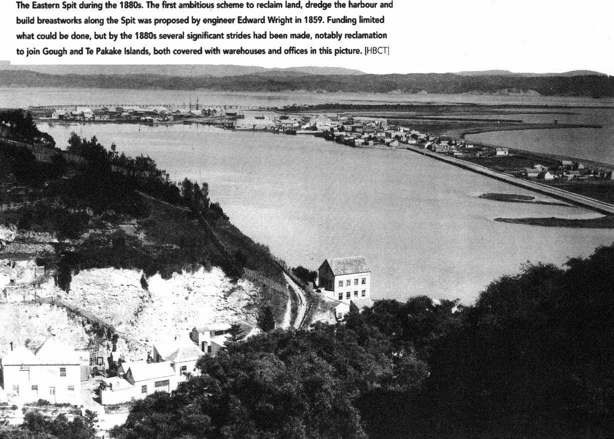
The Eastern Spit during the 1880s. The first ambitious scheme to reclaim land, dredge the harbour and build breastworks along the Spit was proposed by engineer Edward Wright in 1859. Funding limited what could be done, but by the 1880s several significant strides had been made, notably reclamation to join Gough and Te Pakake Islands, both covered with warehouses and offices in this picture. [HBCT]

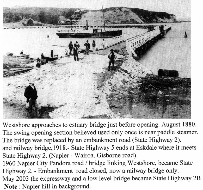
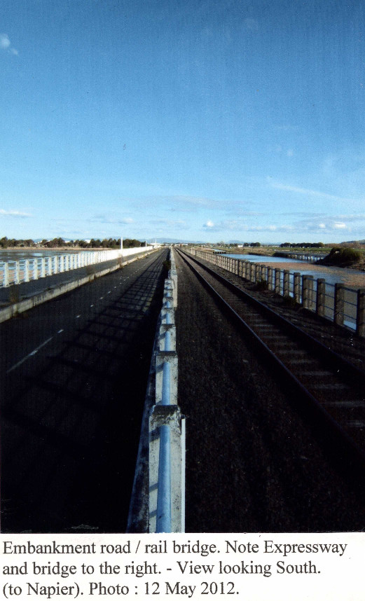
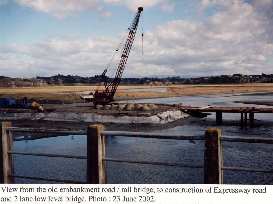
Westshore approaches to estuary bridge just before opening. August 1880. The swing opening section believed used only once is near paddle steamer. The bridge was replaced by an embankment road (State Highway 2). and railway bridge, 1918.- State Highway 5 ends at Eskdale where it meets State Highway 2. (Napier – Wairoa, Gisborne road).
1960 Napier City Pandora road / bridge linking Westshore, became State Highway 2. – Embankment road closed, now a railway bridge only.
May 2003 the expressway and a low level bridge became State Highway 2B
Note : Napier hill in background.


NAPIER TAUPO ROAD – Brief History. (A reference : book “Coaches North”)
The first established stage coach passenger transport service was started by a Mr Peters on 1st January 1872 leaving Napier at 6am for Taupo. A two day journey, involving some walking. Over the years there were also many other stage coach operators.
1906 – The Hawke’s Bay Motor Co, to launch onto the Napier Taupo Road, purchased the well founded coaching firm of Crowther & McCauley who had traversed the Napier Taupo road for nearly 20 years.
Hawke’s Bay Motor Co’s Stage Coach journey over the Napier Taupo road involved at least 30 horses to give 5 changes over a 2 day journey, with a night stay at the Tarawera Hotel. Passengers travelling South of Taupo stopped at the Terraces Hotel, carrying on by Lake steamer to Tokaanu, or to National Park Train Station. The journey ended at the Wairakei Hotel where travellers changed to coaches travelling to Rotorua and Hamilton.
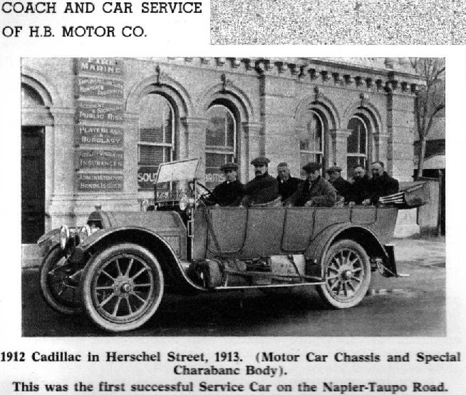
1913 – The Hawke’s Bay Motor Co introduced a Cadillac 9 seater service car. In good conditions, departed Napier 8.00am arrived Taupo same day at 5pm. Ending the journey at Wairakei Hotel. The vehicle carried spade, rope and chains.
Present day : year 2012. – The modern powerful diesel air conditioned Coaches, carrying 42 passengers on air-bag suspension ensuring comfortable travel, complete the Napier Taupo Road in 2 hours.
(Michael Palmer Tuck: May 2012).
CROWTHER, JOSEPH, Manager of the Taupo Branch for Messrs Crowther and McCauley, Coach Proprietors. Mr. Crowther was born in 1862, in Wellington. In 1883 he established himself in Taupo as a butcher, and conducted the business for sixteen years. Since 1896 Mr. Crowther has been in charge of the business of the firm at the Taupo end. He has been a member of the Taupo Domain Board since its commencement. Mr. Crowther was married, in 1896, to a daughter of Mr. G. Hobbs, of Napier, and has one son and one daughter.

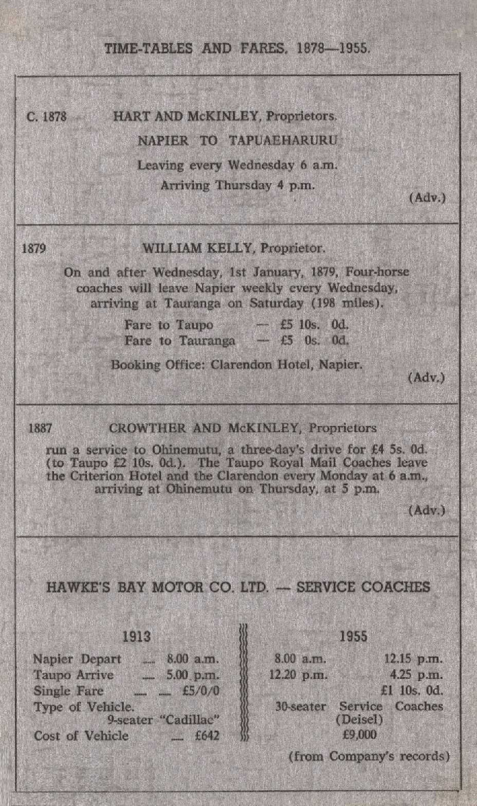
TIME-TABLES AND FARES. 1878-1955;
C. 1878 HART AND McKINLEY, Proprietors.
NAPIER TO TAPUAEHARURU
Leaving every Wednesday 6 a.m.
Arriving Thursday 4 p.m.
(Adv.)
1879 WILLIAM KELLY, Proprietor.
On and after Wednesday, 1st January, 1879 Four-horse coaches will leave Napier weekly every Wednesday, arriving at Tauranga on Saturday (198 miles).
Fare to Taupo – £5 10s. 0d.
Fare to Tauranga – £5 0s. 0d.
Booking Office: Clarendon Hotel, Napier.
(Adv.)
1887 CROWTHER AND McKINLEY, Proprietors
run a service to Ohinemutu, a three day drive for £4 5s. 0d (to Taupo £2 10s. 0d.) The Taupo Royal Mail Coaches leave the Criterion Hotel and the Clarendon every Monday at 6 am, arriving at Ohinemutu on Thursday, at 5 pm.
(Adv.)
HAWKE’S BAY MOTOR CO. LTD. – SERVICE COACHES
1913 1955
Napier Depart 8.00 a.m. 8.00 a.m. 12.15 p.m.
Taupo Arrive 5.00 p.m. 12.20 p.m. 4.25 p.m.
Single Fare £5/0/0 £1 10s. 0d.
Type of Vehicle. 9-seater “Cadillac” 30-seater Service Coaches (Deisel [Diesel])
Cost of Vehicle £642 £9,000
(from Company’s records)

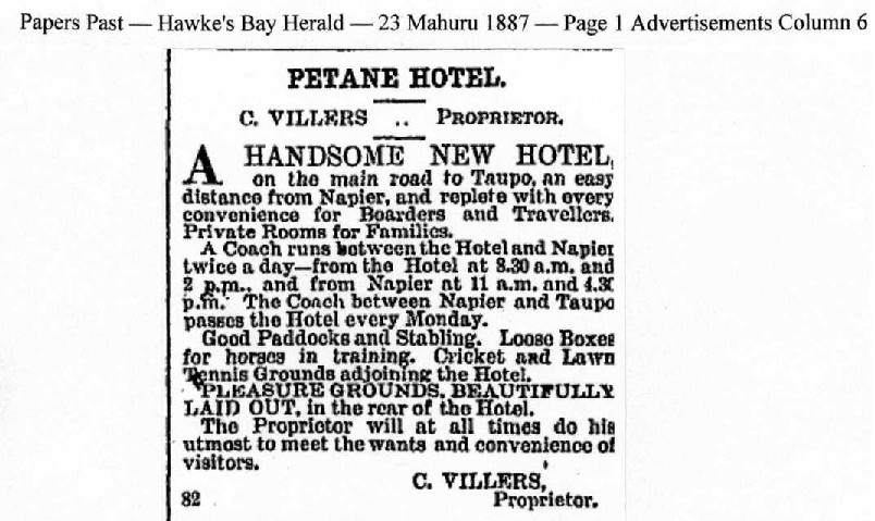
Papers Past – Hawke’s Bay Herald – 23 Mahuru 1887 – Page 1 Advertisements Column 6
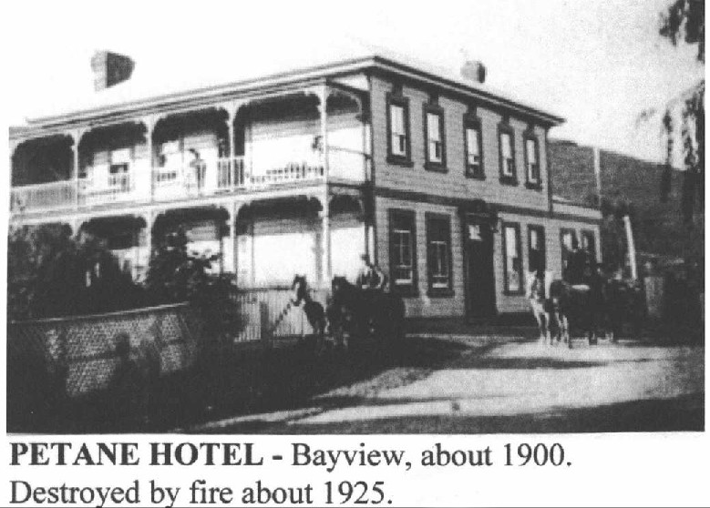
PETANE HOTEL.
C. VILLERS – PROPRIETOR.
A HANDSOME NEW HOTEL on the main road to Taupo, an easy distance from Napier, and replete with every convenience for Boarders and Travellers. Private Rooms for Families.
A Coach runs between the Hotel and Napier twice a day – from the Hotel at 8.30 a.m. and 2 p.m. and from Napier at 11 a.m. and 4.30 p.m. The Coach between Napier and Taupo passes the Hotel every Monday.
Good Paddocks and Stabling. Loose Boxes for horses in training. Cricket and Lawn Tennis grounds adjoining the Hotel.
PLEASURE GROUNDS, BEAUTIFULLY LAID OUT, in the rear of the Hotel.
The Proprietor will at all times do his utmost to meet the wants and convenience of visitors.
C. VILLERS, Proprietor.
82

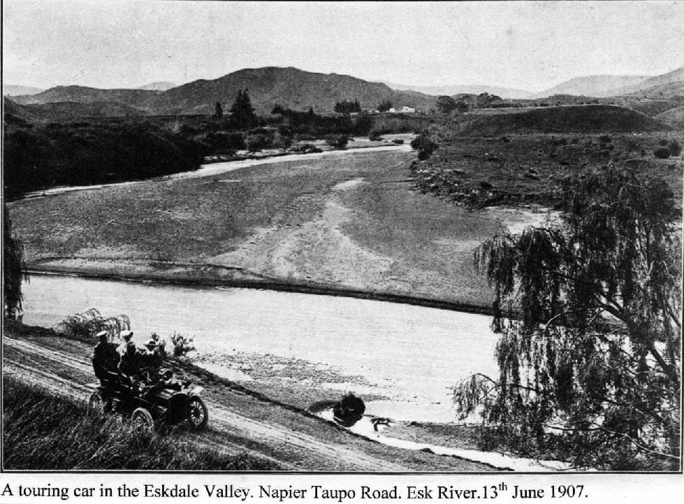
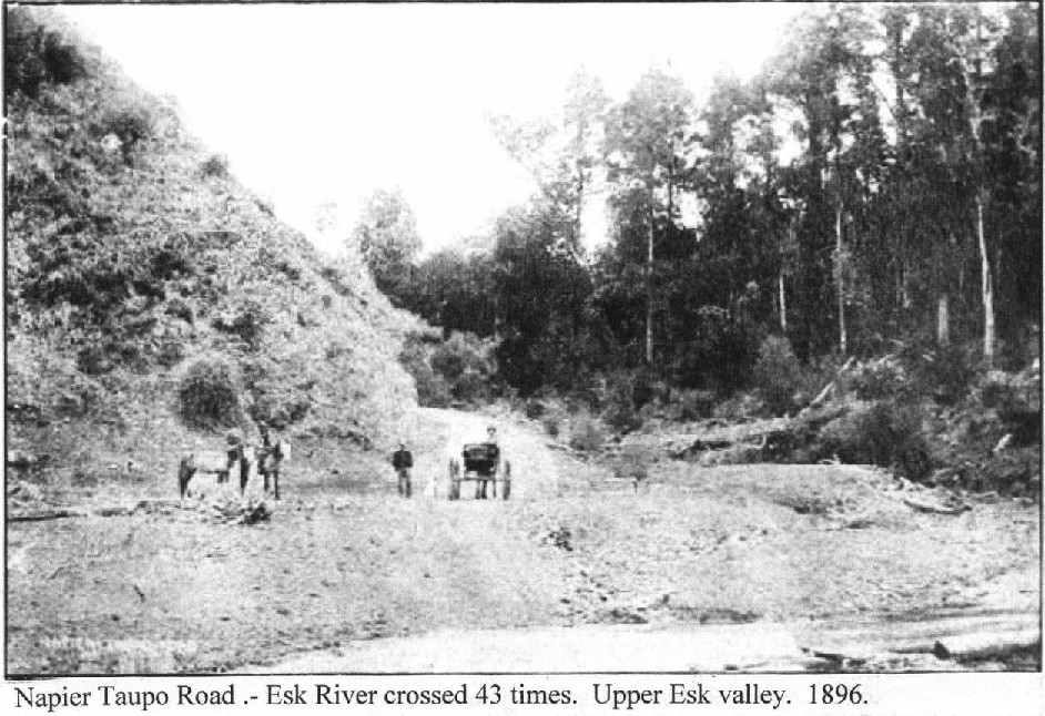
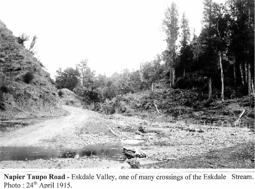
Napier Taupo Road – Eskdale Valley. View to Taupo. Centre – before, where road rises and disappears, road crosses Munns bridge, the stream flows to right into Esk River.
Now days (2013) top of rise – left – airstrip, to right Ellis Wallis Road.
Over years road seen realignments particularly after the devastating 1938 Esk Valley floods.


Robert Holt & Sons Ltd, Ohurakura, – 5 kilometres down the Ohurakura Road, opposite the Te Pohue Golf links. 1,250 feet above sea level. (381 meters). – 28 miles (45 kilometres) from Napier.
Commenced cutting 1923. In the latter years were drawing native logs from the Runanga block, on the Rangitaiki Plains. Sawmill closed 1959. Photo taken from Ohurakura Road. 1935.

Robert Holt & Sons Ltd, Ohurakura sawmill. (1923 – 1959) – View looking across sawmill and houses to Ohurakura Road descending hill. From right, about 5 kilometres to Napier Taupo Road. Water supply for houses and school was roof rainwater directed into a buildings tank. No provision was made to supply generate electricity to the houses or school. Candles and paraffin lamps was the norm. – Photo : 1935.


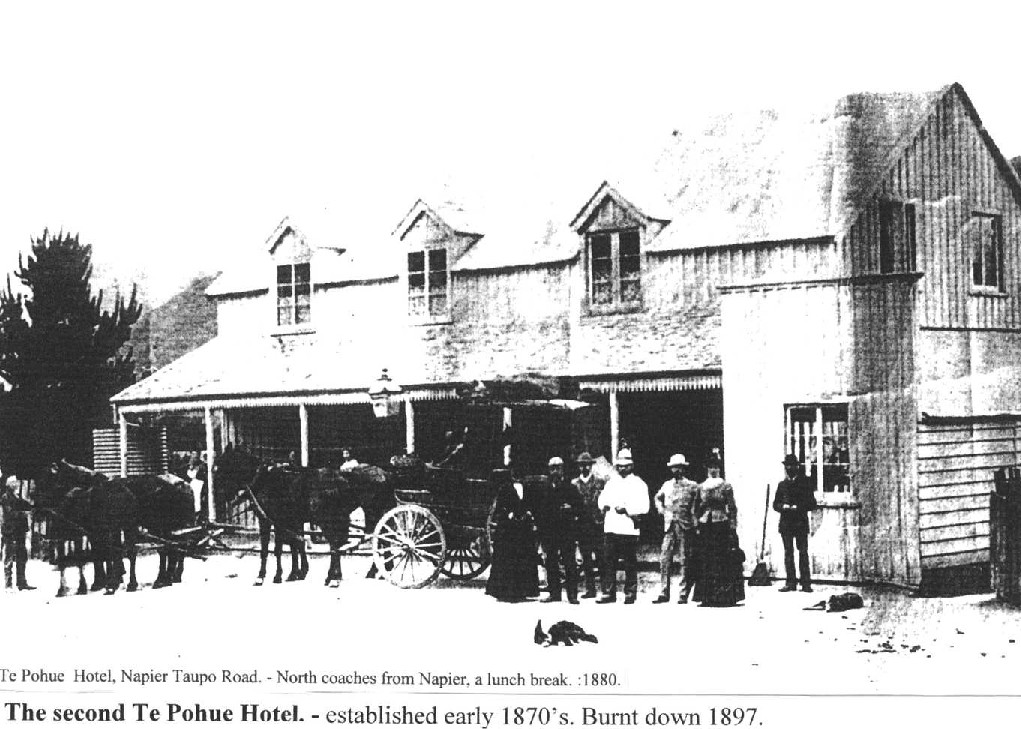
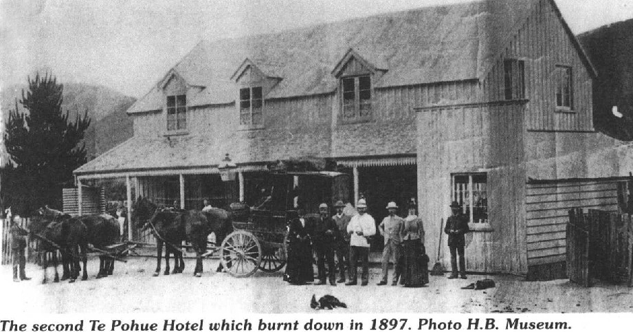
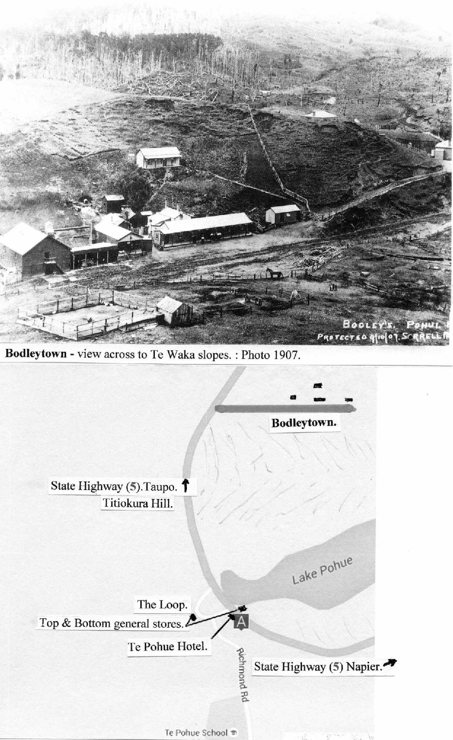
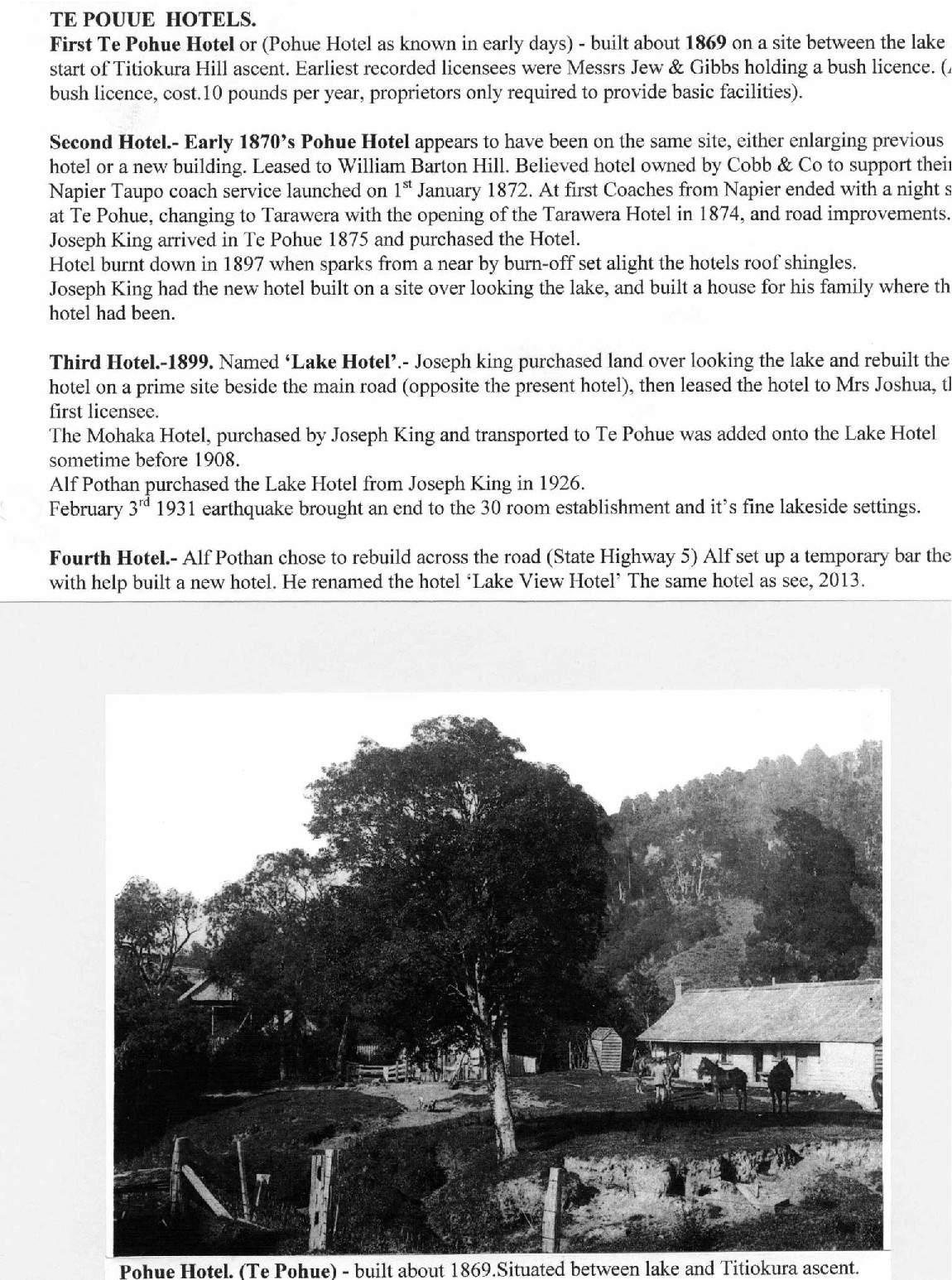
TE POUUE [POHUE] HOTELS.
First Te Pohue Hotel or (Pohue Hotel as known in early days) – built about 1869 on a site between the lake start of Titiokura Hill ascent. Earliest recorded licensees were Messrs Jew & Gibbs holding a bush licence. (A bush licence, cost. 10 pounds per year, proprietors only required to provide basic facilities).
Second Hotel. – Early 1870’s Pohue Hotel appears to have been on the same site, either enlarging previous hotel or a new building. Leased to William Barton Hill. Believed hotel owned by Cobb & Co to support their Napier Taupo coach service launched on 1st January 1872. At first Coaches from Napier ended with a night at Te Pohue, changing to Tarawera with the opening of the Tarawera Hotel in 1874, and road improvements.
Joseph King arrived in Te Pohue 1875 and purchased the Hotel.
Hotel burnt down in 1897 when sparks from a near by burn-off set alight the hotels roof shingles.
Joseph King had the new hotel built on a site over looking the lake, and built a house for his family where the hotel had been.
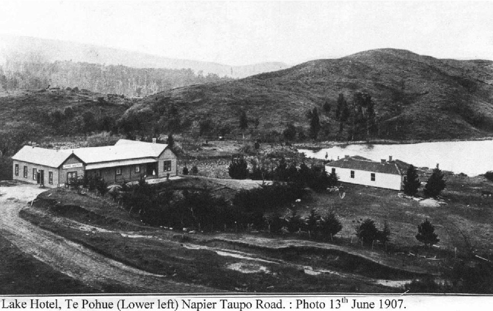
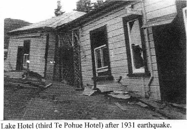
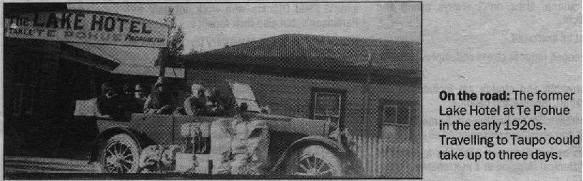
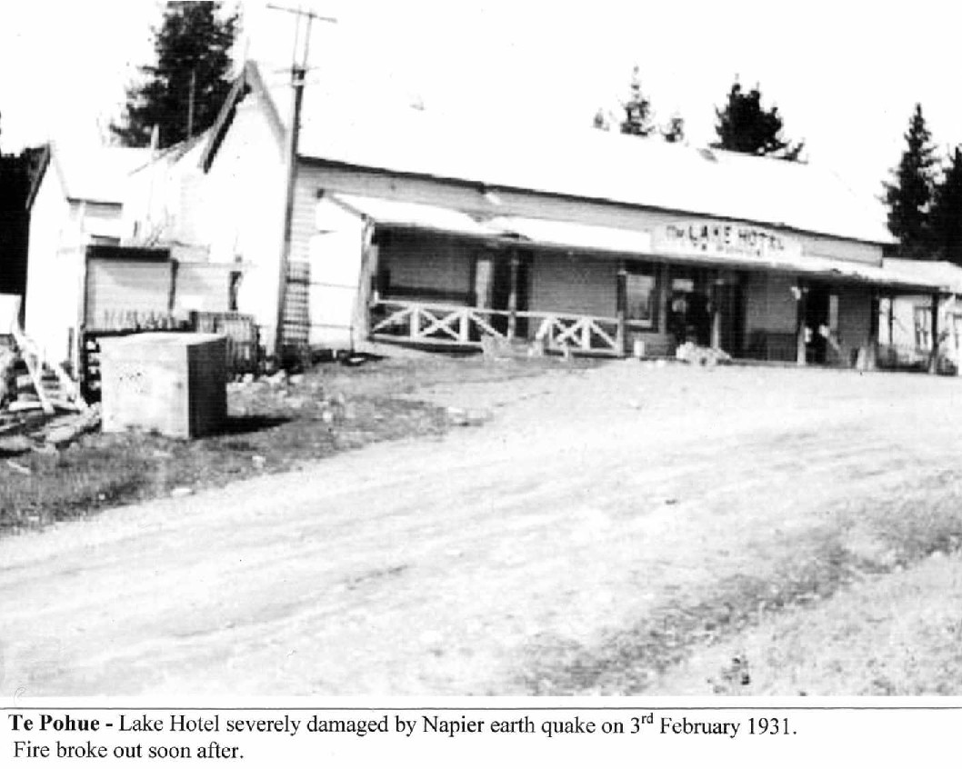
Third Hotel. – 1899. Named ‘Lake Hotel’. – Joseph king [King] purchased land over looking the lake and rebuilt the hotel on a prime site beside the main road (opposite the present hotel), then leased the hotel to Mrs Joshua, the first licensee.
The Mohaka Hotel, purchased by Joseph King and transported to Te Pohue was added onto the Lake Hotel sometime before 1908.
Alf Pothan purchased the Lake Hotel from Joseph King in 1926.
February 3rd 1931 earthquake brought an end to the 30 room establishment and it’s fine lakeside settings.
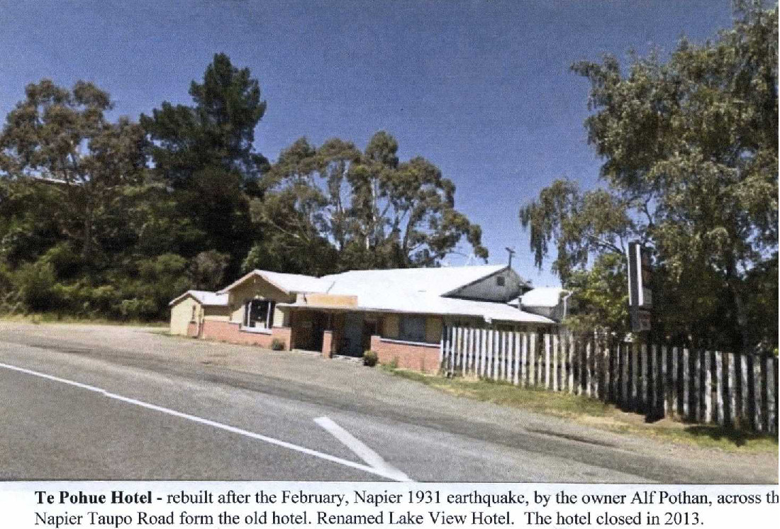
Fourth Hotel. – Alf Pothan chose to rebuild across the road (State Highway 5) Alf set up a temporary bar the[n] with help built a new hotel. He renamed the hotel ‘Lake View Hotel’ The same hotel as see [seen], 2013.
Pohue Hotel. (Te Pohue) – built about 1869. Situated between lake and Titiokura ascent.

MAP – Te Pohue 28 miles (46 kilometres) from Napier.- Napier Taupo Road (State Highway 5).
Mohaka R.
S.H.5.
Mangawhata S [Stream]
MAUNGAHURURU RANGE
TITIOKURA
TE WAKA RANGE
Microwave Station
Kings S
Te Pohue
Ohurakura Road
Berry Road
Claymore Road
Deep S
Esk R [River]
Waikinakitangata S
Te Waka Road
Old Coach Road
Pokopoko S
Waipuna S
Mangaone R
WAHI TAPU LOCATION MAP
A Urupa and fortification; B Bird-snaring camp; C Te Waka; D Pirinoa Pa; E Taurua O Ngarengare; F Tauira – Mateawha; G Pa on Little Richmond Hill; H Pits on Big Richmond Hill; I Kainga on the Waikinakitangata Stream; J Motuoruru Pa; K Pokopoko Ravine; L Te Pohue Lake; M Te Pohue Pa; N Urupa below Pohue Pa; O Other urupa; P Te Kooti’s Fortress; Q Waka A Te O; R Te Ahimanawa A Kohipipi; S Urupa at Waitara; T Kahungunu – Rongomaipapa; U Ngakokako Stream; V Pa on Island Farm; W Pa on site on Berry Road; X Posts at junction of North Block Gorge and Esk.

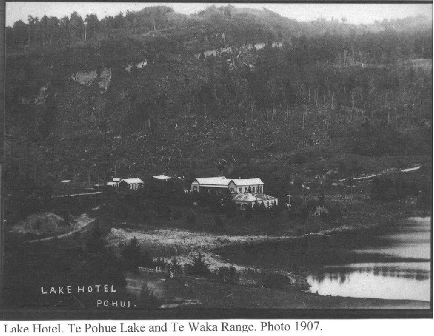


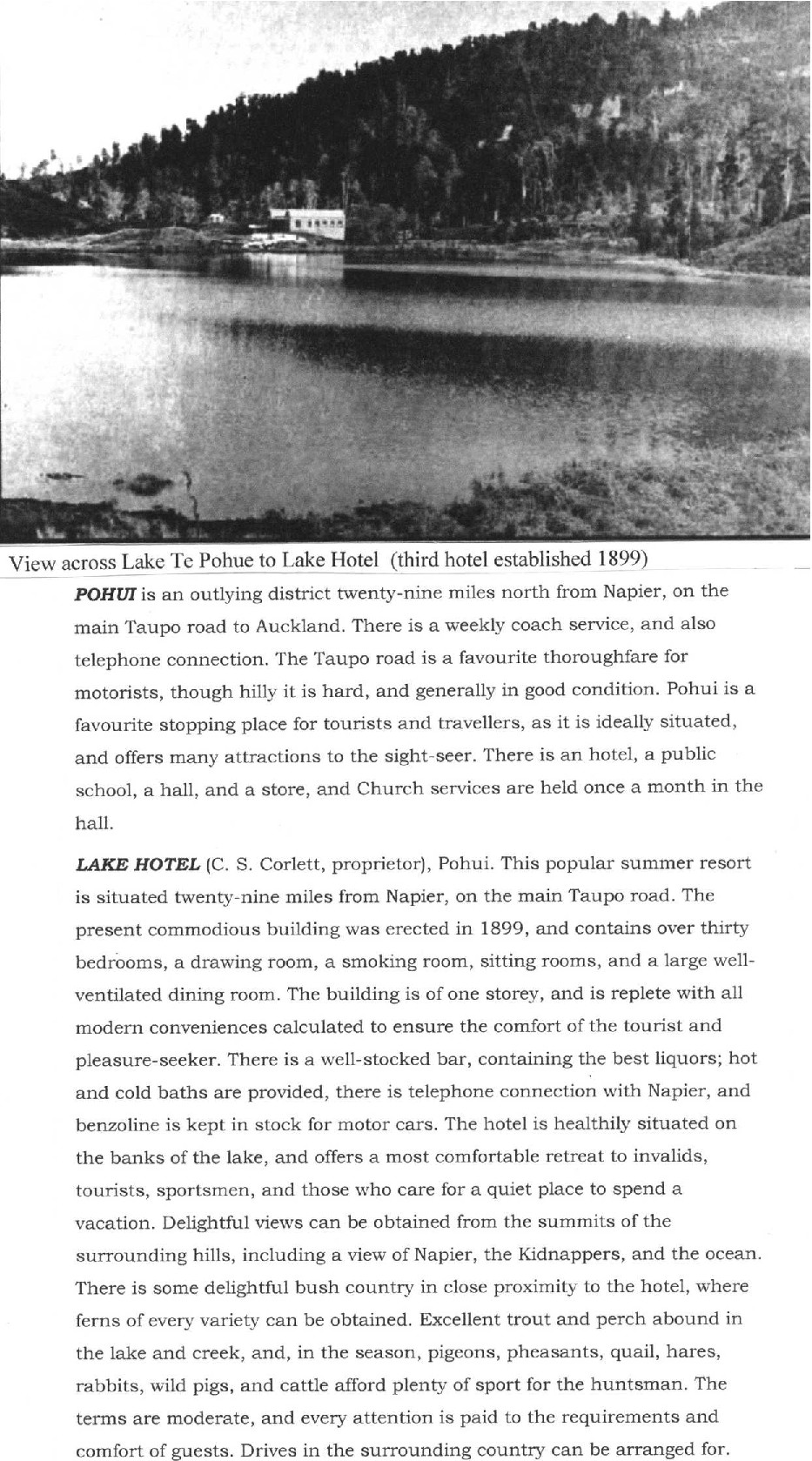
View across Lake Te Pohue to Lake Hotel (third hotel established 1899)
POHUI is an outlying district twenty-nine miles north from Napier, on the main Taupo road to Auckland. There is a weekly coach service, and also telephone connection. The Taupo road is a favourite thoroughfare for motorists, though hilly it is hard, and generally in good condition. Pohui is a favourite stopping place for tourists and travellers, as it is ideally situated, and offers many attractions to the sight-seer. There is an hotel, a public school, a hall, and a store, and Church services are held once a month in the hall.
LAKE HOTEL (C. S. Corlett, proprietor), Pohui. This popular summer resort is situated twenty-nine miles from Napier, on the main Taupo road. The present commodious building was erected in 1899, and contains over thirty bedrooms, a drawing room, a smoking room, sitting rooms, and a large well-ventilated dining room. The building is of one storey, and is replete with all modern conveniences calculated to ensure the comfort of the tourist and pleasure-seeker. There is a well-stocked bar, containing the best liquors; hot and cold baths are provided, there is telephone connection with Napier, and benzoline is kept in stock for motor cars. The hotel is healthily situated on the banks of the lake, and offers a most comfortable retreat to invalids, tourists, sportsmen, and those who care for a quiet place to spend a vacation. Delightful views can be obtained from the summits of the surrounding hills, including a view of Napier, the Kidnappers, and the ocean. There is some delightful bush country in close proximity to the hotel, where ferns of every variety can be obtained. Excellent trout and perch abound in the lake and creek, and, in the season, pigeons, pheasants, quail, hares, rabbits, wild pigs, and cattle afford plenty of sport for the huntsman. The terms are moderate, and every attention is paid to the requirements and comfort of guests. Drives in the surrounding country can be arranged for.

Te Pohue General Store & Post Office. – About 1899 built as a billiard saloon. 1910 converted into a general store to replace the burnt down store. Known as ‘Bottom’ store. Road realignment in 1947 left the store in a loop road denying direct passing traffic. Hawke’s Bay Motor Co, buses still called because of the Post Office and to collect stores for delivery to the sawmills and road workers along the Napier Taupo Road. The store closed in 1967, the Post Office was moved to the ‘top’ store. : Photo 1910.


TE POHUE SCHOOL, JUNE 1930. Welsh, HASTINGS.
Te Pohue School 1930. From left – Back row: Eric Eaton, Ron Pothan, Jean King, Mrs Palmer (nee Rubick), Jim Howell, Terry Pothan, Pat Howell. Front row: Joe King, Peter King, Pat McRae, Jessie King, Bunty McRobbie, Jim McRobbie, Doris McRobbie, Jeanette McRobbie, Reah McRobbie. Photo Eileen Bruce.


Original digital file
TuckMP1085_SH5_Napier-TePohue.pdf
Non-commercial use

This work is licensed under a Attribution-NonCommercial 3.0 New Zealand (CC BY-NC 3.0 NZ).
Commercial Use
Please contact us for information about using this material commercially.Can you help?
The Hawke's Bay Knowledge Bank relies on donations to make this material available. Please consider making a donation towards preserving our local history.
Visit our donations page for more information.
Description
More items in this collection will be added in due course
Other surnames in this folder – Benker, Burrough, Crowther, Dempsey, Gibbs, Jew, Joshua, McCauley, Nichol, Palmer (nee Rubick)
Tags
Format of the original
Folder of photocopied photos and typed textDate published
2016People
- Eileen Bruce
- C S Corlett
- Eric Eaton
- G Goff
- William Barton Hill
- George Hobbs
- Robert Holt
- Jill Howell
- Pat Howell
- Jack Izatt
- William Kellly
- Jean King
- Jessie King
- Joe King
- Joseph King
- Peter King
- Pat McRae
- Bunty McRobbie
- Doris McRobbie
- Jeanette McRobbie
- Jim McRobbie
- Reah McRobbie
- A Peters
- Aidan Pothan
- Alf Pothan
- Ron Pothan
- D Scannell
- K & J Smith
- C Villers
- Edward Wright
Accession number
454905Supporters and sponsors
We sincerely thank the following businesses and organisations for their support.


Do you know something about this record?
Please note we cannot verify the accuracy of any information posted by the community.