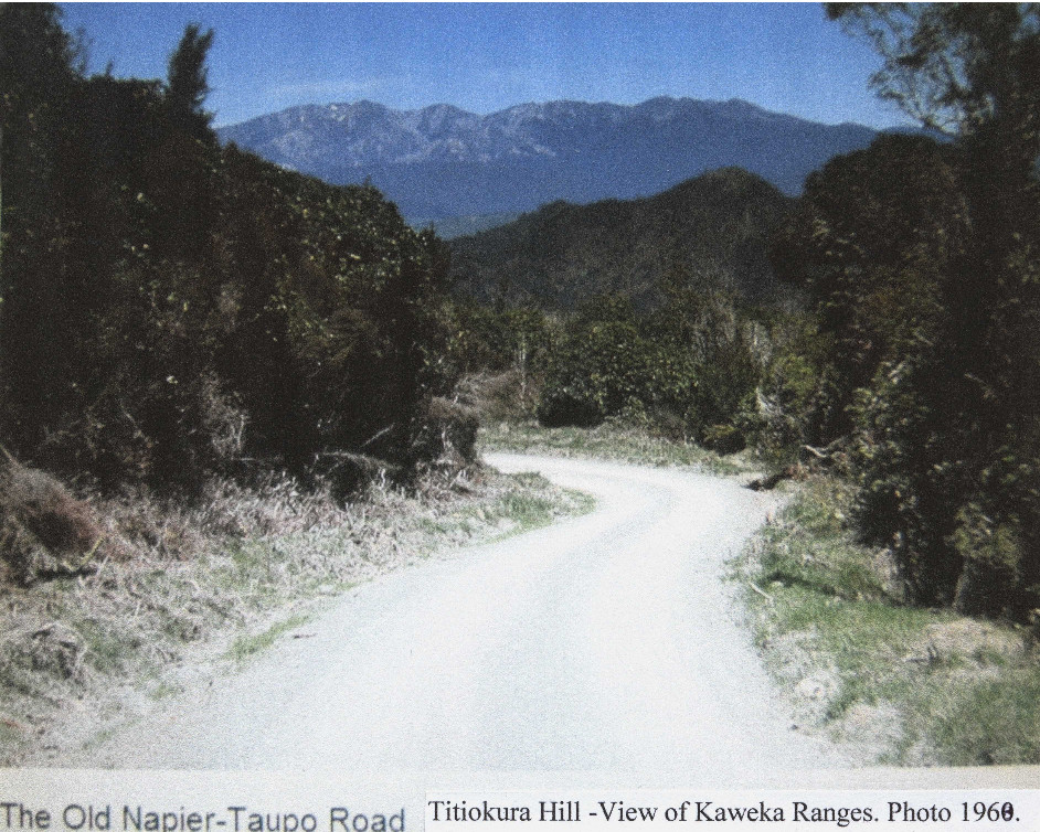
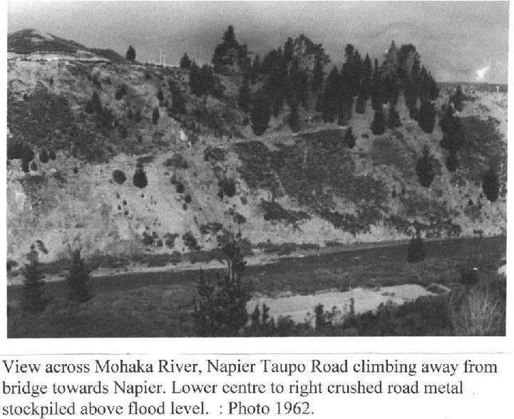
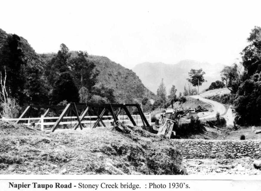
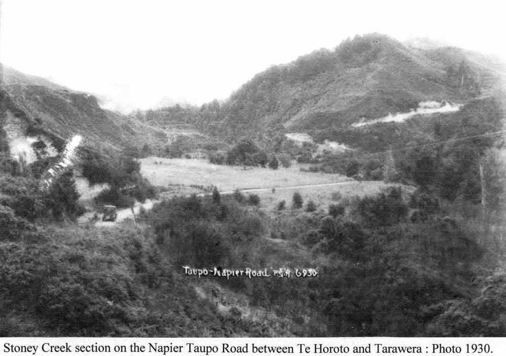
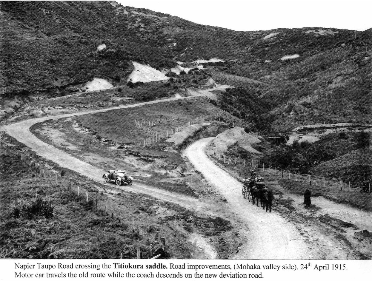
State Highway 5 – Titiokura to Stoney Creek
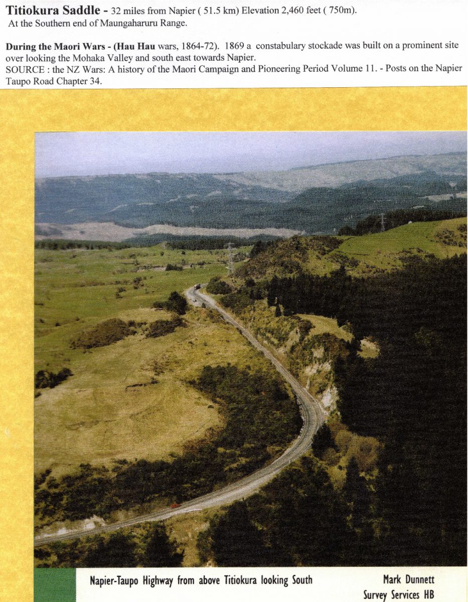
Titiokura Saddle – 32 miles from Napier (51.5 km) Elevation 2,460 feet (750m).
At the Southern end of Maungaharuru Range.
During the Maori Wars – (Hau Hau wars, 1864-72). 1869 a constabulary stockade was built on a prominent site over looking the Mohaka Valley and south east towards Napier.
SOURCE : the NZ Wars: A history of the Maori Campaign and Pioneering Period Volume II. – Posts on the Napier Taupo Road Chapter 34.
Napier-Taupo Highway from above Titiokura looking South
Mark Dunnett
Survey Services HB


PAGE TEN THE DAILY TELEGRAPH, WEDNESDAY, MAY 11, 1966
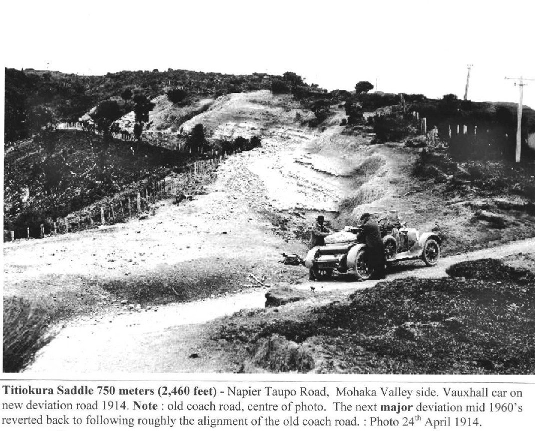
Titiokura deviation to open tomorrow.
With the raising of two barriers tomorrow morning, the Ministry of Works will eliminate one of the worst sections of the Napier-Tau po highway – the tortuous north-western side of the Titiokura Saddle.
Traffic will be able to use a giant deviation for the first time when barriers at both ends are raised about 9.15 am.
Wet weather in the past few days had prevented the whole deviation from being sealed, the Ministry of Works district engineer, Mr R.D. Grant, said today.
The 30 chains of unsealed surface would, however, be “perfectly all right,” he said.
It was unlikely that this section could be sealed before the Winter proper, “but sealing is not completely out of our minds. We might get a dry spell. It would take some weeks to clean up the area,”
FIRST TO CROSS
The first vehicle to use the new deviation would be a bus bound for Wairakei, he said.
The Titiokura Saddle is where the highway crosses the Maungaharuru Range about 33 miles north-west of Napier.
A huge improvement project on the Taupo side of the new deviation has been in use for some time. The complete Titiokura scheme will have grades no steeper than one in 11- a feature to be welcomed by heavy traffic.
The twisting, steep section to be replaced by the deviation has always been a hazard, particularly in wet weather. It has grades of one in seven.
NEXT TASK
With the near completion of the Titiokura deviation the focus of attention on the highway will be Stoney Creek and the mammoth Runanga deviation.
Work at Stoney Creek, where the highway consists of some of the worst grades on the whole route is well under way.
Involving 3,000,000 cubic yards of earthworks, the Stoney Creek project is expected to be finished by next Christmas.
It has involved the installation of probably the biggest semi-elliptical culvert of its kind in the Southern Hemisphere.
The first formation contract for the Runanga deviation, about 36 miles south-east of Taupo, will be called soon. It will be for the formation of 1½ miles at the Napier end. Tenders closed last month for a clearing contract, mainly in the middle section.
Tenders will probably be called in September for the formation of two miles at the Taupo end. Surveyors are working in this section.
MR A. I. KENNARD, secretary of the Automobile Association (Hawke’s Bay), with traffic signs to be positioned today on the Titiokura deviation which is to be opened this week. Mr Kennard is holding the first sign of its kind to be used in Hawke’s Bay. It tells motorists the three-lane road is changing to two-lanes.


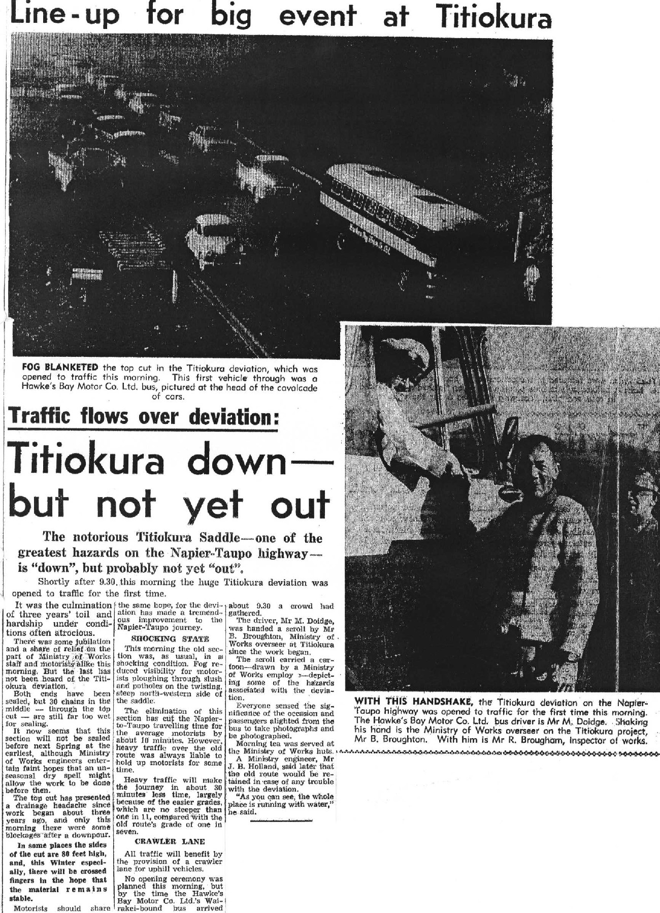
Line-up for big event at Titiokura
Traffic flows over deviation:
Titiokura down – but not yet out
The notorious Titiokura Saddle one of the greatest hazards on the Napier-Taupo highway is “down”, but probably not yet “out”.
Shortly after 9.30. this morning the huge Titiokura deviation was opened to traffic for the first time.
It was the culmination of three years toil and hardship under conditions often atrocious.
There was some jubilation and a share of relief on the part of Ministry of Works staff and motorist alike this morning. But the last has not been heard of the Titiokura deviation.
Both ends have been sealed but 30 chains in the middle – through the top cut – are still far too wet for sealing.
It now seems that this section will not be sealed before next Spring at the earliest, although Ministry of Works engineers entertain faint hopes that an unseasonal dry spell might allow the work to be done before then.
The top cut has presented a drainage headache since work began about three years ago, and only this morning there were some blockages after a downpour.
In some places the sides of the cut are 80 feet high, and, this winter especially, there will be crossed fingers in the hope that the material remains stable.
Motorists should share the same hope, for the deviation has made a tremendous improvement to the Napier-Taupo journey.
SHOCKING STATE
This morning the old section was, as usual, in a shocking condition. Fog reduced visibility for motorists ploughing through slush and potholes on the twisting steep north-western side of the saddle. The elimination of this section has cut the Napier-to-Taupo travelling time for the average motorists by about 10 minutes. However, heavy traffic over the old route was always liable to hold up motorists for some time.
Heavy traffic will make the journey in about 30 minutes less time, largely because of the easier grades, which are no steeper than one in 11, compared with the old route’s grade of one in seven.
CRAWLER LANE
All traffic will benefit by the provision of a crawler lane for uphill vehicles.
No opening ceremony was planned this morning, but by the time the Hawke’s Bay Motor Co. Ltd.’s Wairakei-bound bus arrived about 9.30 a crowd had gathered.
The driver, Mr M. Doidge, was handed a scroll by Mr B. Broughton, Ministry of Work overseer at Titiokura since the work began. The scroll carried a cartoon – drawn by a Ministry of Works employee – depicting some of the hazards associated with the deviation.
Everyone sensed the significance of the occasion and passengers alighted from the bus to take photographs and be photographed.
Morning tea was served at the Ministry of Works huts.
A Ministry engineer, Mr J. B. Holland, said later that the old route would be retained in case of any trouble with the deviation.
“As you can see, the whole place is running with water,” he said.
FOG BLANKETED the top cut in the Titiokura deviation, which was opened to traffic this morning. This first vehicle through was a Hawke’s Bay Motor Co. Ltd. bus, pictured at the head of the cavalcade of cars.
WITH THIS HANDSHAKE, the Titiokura deviation on the Napier-Taupo highway was opened to traffic for the first time this morning. The Hawke’s Bay Motor Co. Ltd. Bus driver is Mr M. Doidge. Shaking his hand is the Ministry of Works overseer on the Titiokura project, Mr B. Broughton. With him is Mr R. Brougham, Inspector of works.


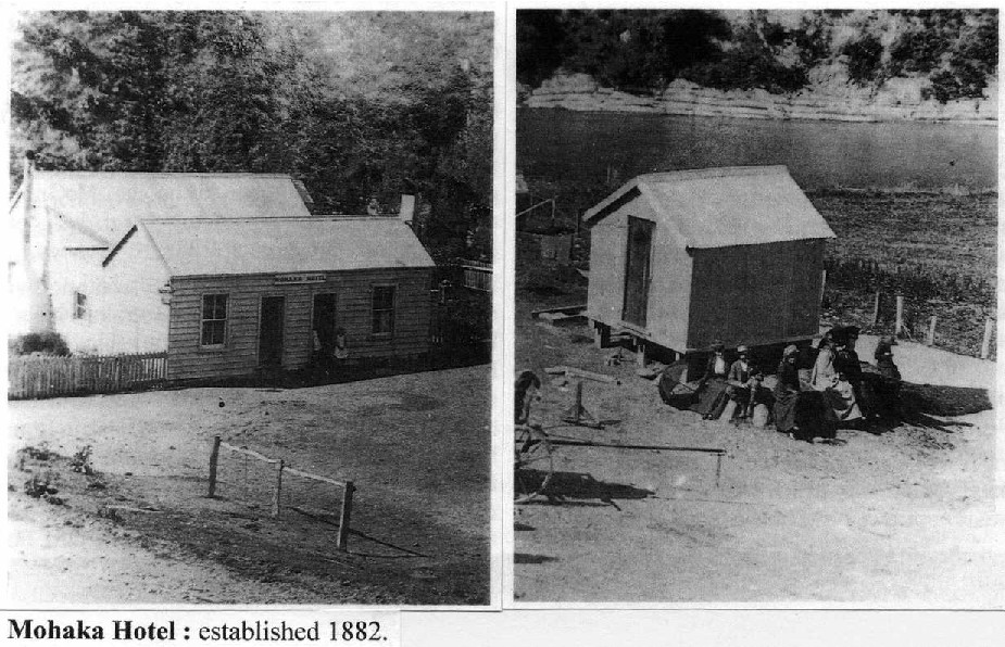
MOHAKA HOTEL : built 1882 – situated on a raised northern Mohaka River bank opposite the Punghuru Stream falls at Church Crossing, later known as Ferry crossing. A stage coach stop to change horses. First proprietor – Patrick Dooney (6 years). Believed hotel burnt down 1901, rebuilt by Edward Newbegin [Newbigin] 1902, a little higher up on a small terrace, then leased to Mr. Haines.
Hotel closed a few years later due to lack of trade. Sold to Joseph King – ‘Lake Hotel’ owner, Te Pohue. The building was dismantled, transported and attached to the ‘Lake Hotel’ at Te Pohue sometime before 1908.
Mohaka Hotel, at Church Crossing. : 1882. : Note – (centre), Mohaka River, Punghuru [Pungahuru] Stream water falls. Background, (just seen) Te Waka Range. (Left), road from Napier descending to Mohaka River crossing. : 1882.

WALKING & DRIVING INSTRUCTIONS. (2009).
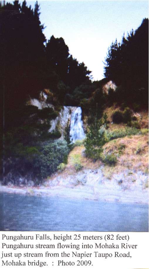
There is a car park at the end of McVicar Road. A gate is located on the road to the falls. There is no track to the falls, they are across the Mohaka River, but may be seen from the car park. The car park is the site of the upper Mohaka Hotel – 1882 to about 1908.
Taupo Napier
McVicar Road.
Airstrip
Hall
WAITARA ROAD
Cotswold
Pungahuru Falls

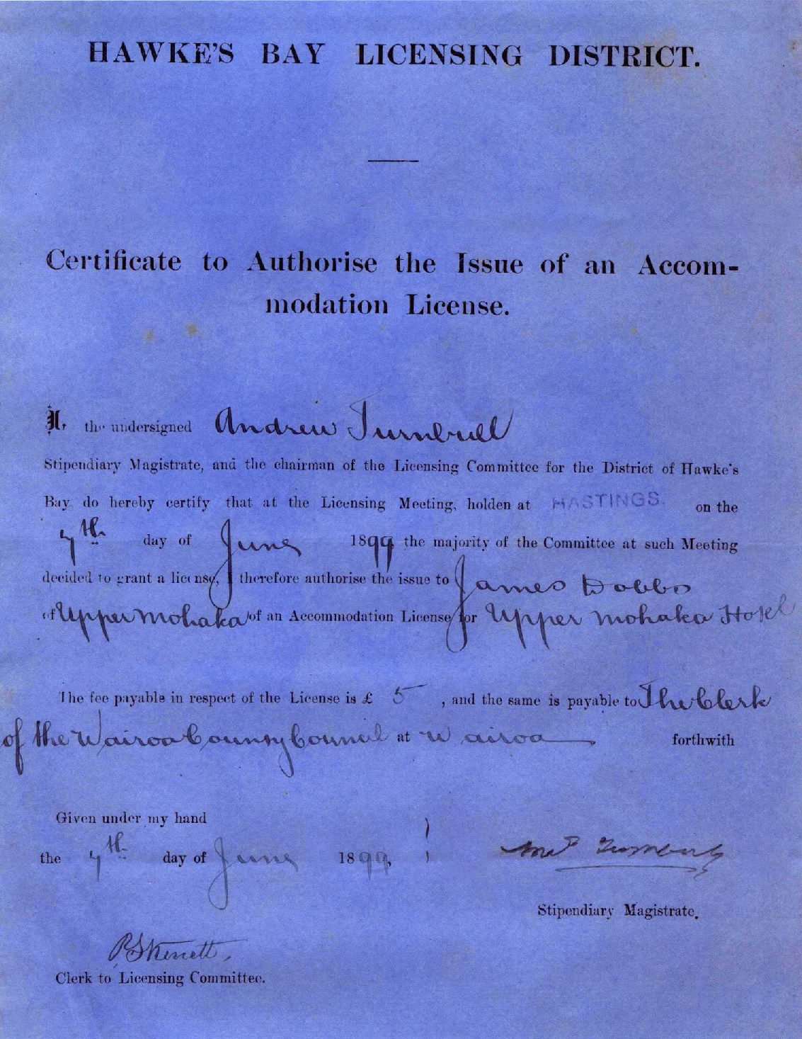
HAWKE’S BAY LICENSING DISTRICT.
Certificate to Authorise the Issue of an Accommodation License.
We the undersigned Andrew Turnbull
Stipendiary Magistrate, and the chairman of the Licensing Committee for the District of Hawke’s Bay do hereby certify that at the Licensing Meeting, holden at HASTINGS on the 7th day of June 1899 the majority of the Committee at such Meeting decided to grant a license, I therefore authorise the issue to James Dobbs of Upper Mohaka of an Accommodation License for Upper Mohaka Hotel.
The fee payable in respect of the License is £ 5, and the same is payable to The Clerk of the Wairoa County Council at Wairoa forthwith
Given under my hand
the 7th day of June 1899
A Turnbull
Stipendiary Magistrate
R S Kinett
Clerk to Licensing Committee.

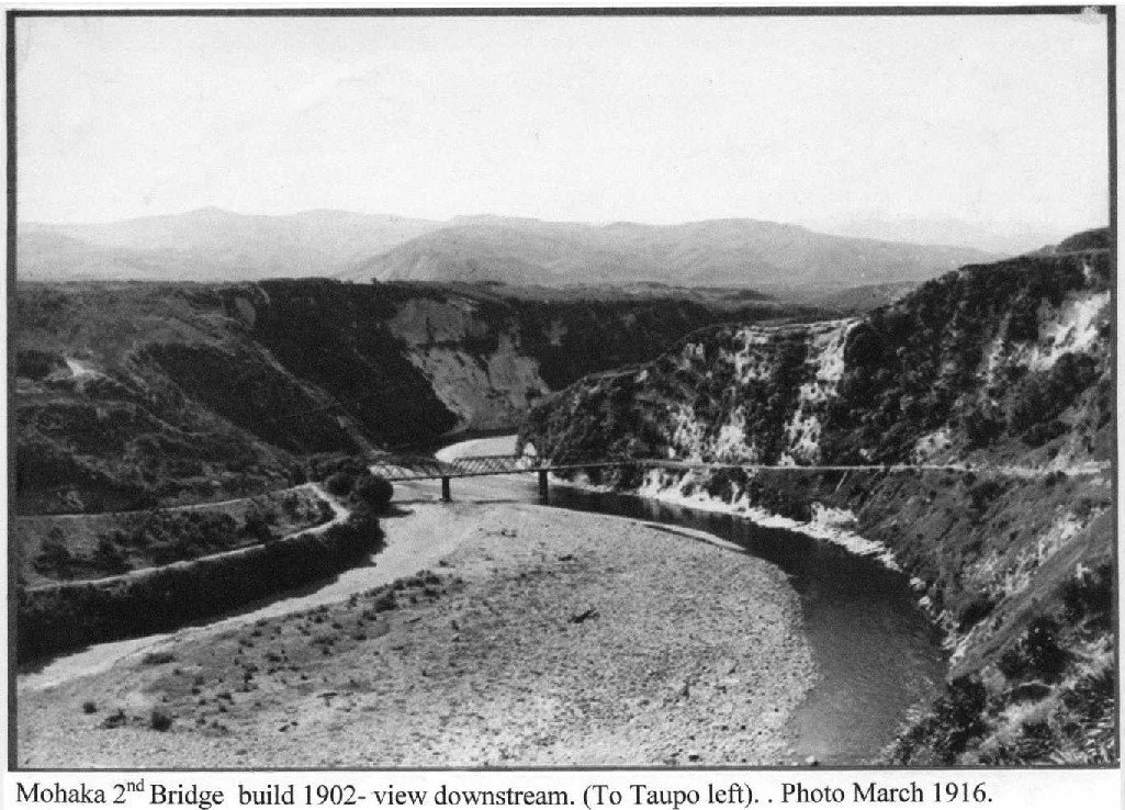
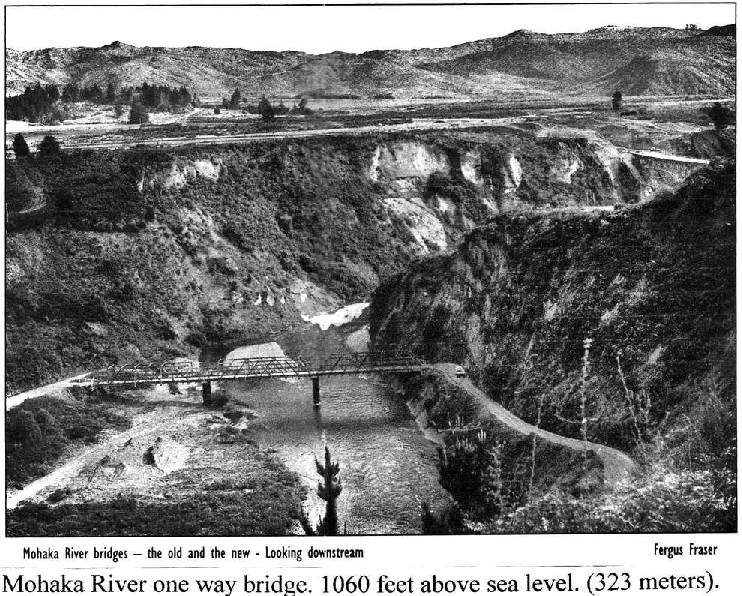
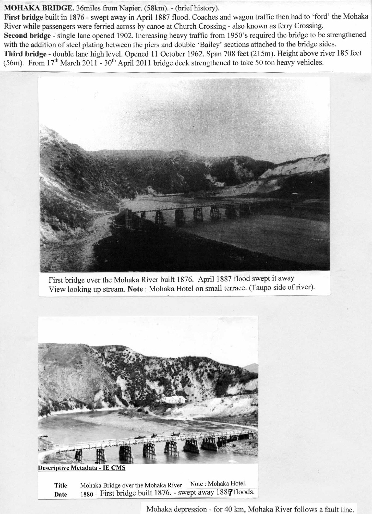
MOHAKA BRIDGE. 36 miles from Napier. (58km). – (brief history).
First bridge built in 1876 – swept away in April 1887 flood. Coaches and wagon traffic then had to ‘ford’ the Mohaka River while passengers were ferried across by canoe at Church Crossing – also known as ferry Crossing.
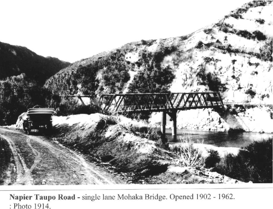
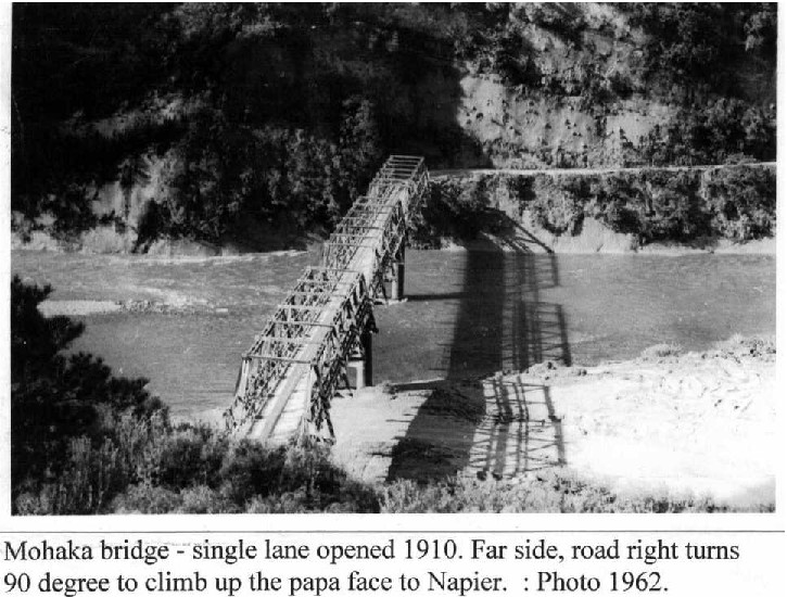
Second bridge – single lane opened 1902. Increasing heavy traffic from 1950’s required the bridge to be strengthened with the addition of steel plating between the piers and double ‘Bailey’ sections attached to the bridge sides.
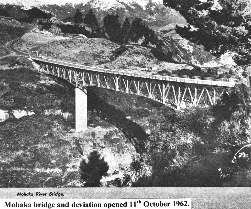
Third bridge – double lane high level. Opened 11 October 1962. Span 708 feet (215m). Height above river 185 feet (56m). From 17th March 2011 – 30th April 2011 bridge deck strengthened to take 50 ton heavy vehicles.
First bridge over the Mohaka River built 1876. April 1887 flood swept it away
View looking up stream. Note : Mohaka Hotel on small terrace. (Taupo Side of river).
Descriptive Metadata – IE CMS
Title Mohaka Bridge over the Mohaka River Note: Mohaka Hotel.
Date 1880 – First bridge built in 1876. – swept away 1887 floods.
Mohaka depression – for 40 km, Mohaka River follows a fault line.

Papers Past > Bay of Plenty Times > 21 April 1897 > Page 2 > Terrible floods in Hawkes Bay. GREAT LOSS OF LIFE.
Terrible floods in Hawkes Bay. GREAT LOSS OF LIFE.
Bay of Plenty Times, Volume XXIV, Issue 3537, 21 April 1897, Page 2
Terrible floods in Hawkes Bay.
GREAT LOSS Of LIFE.
£100,000 worth of damage.
At Waitangi bridge the repairs will cost from £20,000 to £30,000.
Taupo, Tuesday. – Very heavy rain fell here last Thursday and Friday flooding all the creeks and rivers and increasing the level of the lake by about 12 inches.
A great deal of damage was done to the roads southward. Both on the Napier and Tokaanu roads the creeks are rising too high to allow the coaches to pass and heavy slips have also made the traffic very difficult.
The bridges over the Mohaka river on the Napier road have been washed away and the coach has been detained at Tarawera on Friday morning.
The passengers bound for Napier intend returning here to go via Rotorua and Auckland as the road is not likely to be open for several days
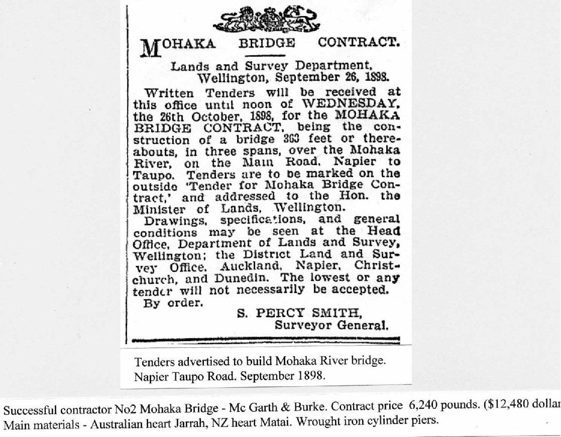
MOHAKA BRIDGE CONTRACT.
Lands and Survey Department, Wellington, September 26. 1898.
Written Tenders will be received at this office until noon of WEDNESDAY, the 26th October, 1898, for the MOHAKA BRIDGE CONTRACT, being the construction of a bridge 363 feet or thereabouts, in three spans, over the Mohaka River, on the Main Road, Napier to Taupo. Tenders are to be marked on the outside “Tender for Mohaka Bridge Contract,” and addressed to the Hon. the Minister of Lands. Wellington.
Drawings, specifications, and general conditions may be seen at the Head Office. Department of Lands and Survey, Wellington; the District Land and Survey Office. Auckland, Napier, Christchurch, and Dunedin. The lowest or any tender will not necessarily be accepted.
By order.
S. PERCY SMITH, Surveyor General
Tenders advertised to build Mohaka River bridge. Napier Taupo Road. September 1898.
Successful contractor No 2 Mohaka Bridge – McGarth [McGrath] & Burke. Contract price 6,240 pounds. ($12,480 dollars)
Main materials – Australian heart Jarrah, NZ heart Matai. Wrought iron cylinder piers.


Mohaka bridge Napier Taupo Road. Photo mid 1950’s. View from north towards Napier. Closer look at strengthening gussets (steel plating) between piers. During 1950’s ‘Bailey Bridge’ sections, double height, placed along both inside, sides at deck height to strengthen the bridge now taking increasingly heavier traffic loads.


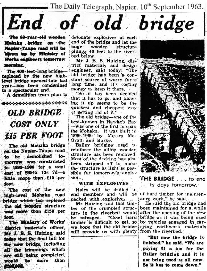
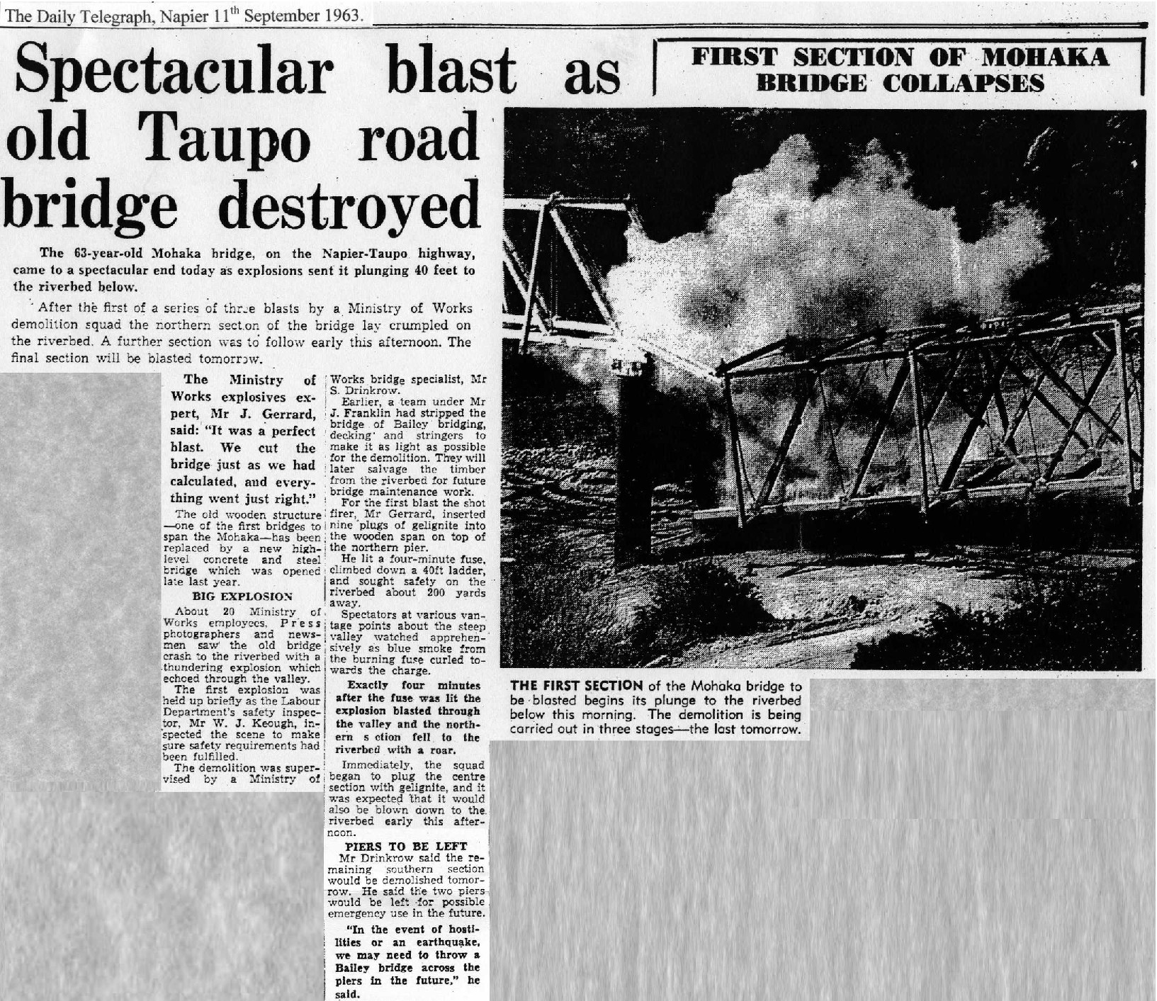
The Daily Telegraph, Napier 11th September 1963.
Spectacular blast as old Taupo road bridge destroyed
The 63-year-old Mohaka bridge, on the Napier-Taupo highway, came to a spectacular end today as explosions sent it plunging 40 feet to the riverbed below.
After the first of a series of three blasts by a Ministry of Works demolition squad the northern section of the bridge lay crumpled on the riverbed. A further section was to follow early this afternoon. The final section will be blasted tomorrow.
The Ministry of Works explosives expert, Mr J. Gerrard, said: “It was a perfect blast. We cut the bridge just as we had calculated and everything went just right.
The old wooden structure: – one of the first bridges to span the Mohaka – has been replaced by a new high-level concrete and steel bridge which was opened late last year.
BIG EXPLOSION
About 20 Ministry of Works employees, Press photographers and newsmen saw the old bridge crash to the riverbed with a thundering explosion which echoed through the valley.
The first explosion was held up briefly as the Labour Department’s safety inspector, Mr W. J. Keough inspected the scene to make sure safety requirements had been fulfilled.
The demolition was supervised by a Ministry of Works bridge specialist, Mr S. Drinkrow.
Earlier, a team under Mr J. Franklin had stripped the bridge of Bailey bridging, decking and stringers to make it as light as possible for the demolition. They will later salvage the timber from the riverbed for future bridge maintenance work.
For the first blast the shot firer, Mr Gerrard, inserted nine plugs of gelignite into the wooden span on top of the northern pier.
He lit a four-minute fuse, climbed down a 40ft ladder, and sought safety on the riverbed about 200 yards away.
Spectators at various vantage points about the steep valley watched apprehensively as blue smoke from the burning fuse curled towards the charge.
Exactly four minutes after the fuse was lit the explosion blasted through the valley and the northern section fell to the riverbed with a roar.
Immediately, the squad began to plug the centre section with gelignite, and it was expected that it would also be blown down to the riverbed early this afternoon.
PIERS TO BE LEFT
Mr Drinkrow said the remaining southern section would be demolished tomorrow. He said the two piers would be left for possible emergency use in the future. In the event of hostilities or an earthquake we may need to throw a Bailey bridge across the piers in the future,” he said.
FIRST SECTION OF MOHAKA BRIDGE COLLAPSES
THE FIRST SECTION of the Mohaka bridge to be blasted begins its plunge to the riverbed below this morning. The demolition is being carried out in three stages – the last tomorrow.

The Daily Telegraph, Napier. 10th September 1963,
End of old bridge
The 63-year-old wooden Mohaka bridge on the Napier-Taupo road will be blown up by Ministry of Works engineers tomorrow morning.
The 400-feet-long bridge – replaced by the new high-level bridge opened late last year has been condemned to a spectacular end. A demolition team plan to detonate explosives at each end of the bridge and let the huge wooden structure plunge 40 feet to the riverbed below.
Mr J. B. S. Huizing, district materials and design engineer, said today: “The old bridge has been a constant source of worry for a long time, and it’s costing money to keep it there.
“So it has been decided that it has to go, and blowing it up seems to be the quickest and cheapest way of getting rid of it.”
The old bridge – one of the best-known in Hawke’s Bay – was one of the first to span the Mohaka. It was built in 1899-1900 by Messrs McGrath and Burke.
Bailey bridging used in reinforce the ailing wooden structure has been removed. Most of the decking has also been stripped of to make the structure as light as possible for tomorrow’s explosion.
WITH EXPLOSIVES
Holes will be drilled in end members and will be packed with explosives.
Mr Huizing said that timber of the crumpled structure in the riverbed would be salvaged. “Good hard timber is difficult to get so we hope that the old bridge will provide us with plenty of hard timber for maintenance work,” he said.
He said the old bridge had been maintained for a while after the opening of the new bridge as it was being used by vehicles engaged in carrying earthwork materials from the riverbed.
“But now the bridge is finished,” he said. “We are paying £1 a ton for the Bailey bridging and it is not being used at all now. So it has to come down.”
OLD BRIDGE COST ONLY £15 PER FOOT
The old Mohaka bridge on the Napier-Taupo road to be demolished tomorrow was constructed in 1899-1900 for a total cost of £6545 13s 7d – a little more than 15 pounds per foot.
The cost of the new high-level Mohaka road bridge which has replaced the old wooden structure was more than £150 per foot.
The Ministry of work’s district materials officer, Mr. J. B. S. Huizing, said today that the final bill for the new bridge, including all the trimmings which are still to be completed would be more than £208,000.
THE BRIDGE…to end its days tomorrow.
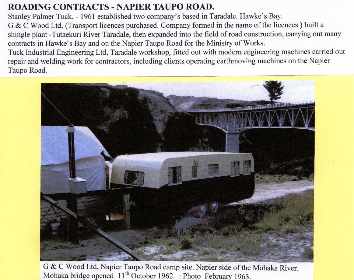
ROADING CONTRACTS – NAPIER TAUPO ROAD.
Stanley Palmer Tuck. – 1961 established two company’s based in Taradale. Hawke’s Bay.
G & C Wood Ltd, (Transport licences purchased. Company formed in the name of the licences) built a shingle plant -Tutaekuri River Taradale, then expanded into the field of road construction, carrying out many contracts in Hawke’s Bay and on the Napier Taupo Road for the Ministry of Works.
Tuck Industrial Engineering Ltd, Taradale workshop, fitted out with modern engineering machines carried out repair and welding work for contractors, including clients operating earthmoving machines on the Napier Taupo Road.
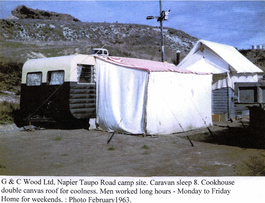
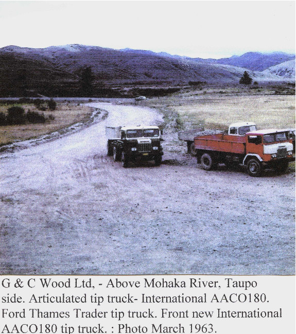
G & C Wood Ltd Napier Taupo Road camp site. Napier side of the Mohaka River
Mohaka bridge opened 11th October 1962. : Photo February 1963.


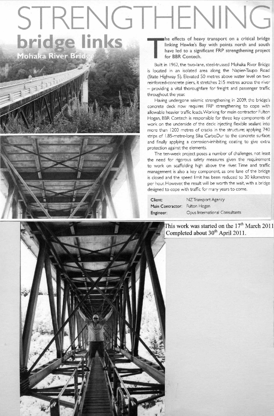
STRENGTHENING bridge links
Mohaka River Bridge
The effects of heavy transport on a critical bridge linking Hawke’s Bay with points north and south have led to a significant FRP strengthening project for BBR Contech.
Built in 1962, the two-lane, steel-trussed Mohaka River Bridge is located in an isolated area along the Napier-Taupo Road (State Highway 5). Elevated 50 metres above water level on two reinforced-concrete piers, it stretches 215 metres across the river – providing a vital thoroughfare for freight and passenger traffic throughout the year.
Having undergone seismic strengthening in 2009, the bridge’s concrete deck now requires FRP strengthening to cope with allowable heavier traffic loads. Working for main contractor Fulton Hogan, BBR Contech is responsible for three key components of work on the underside of the deck injecting flexible sealant into more than 1200 metres of cracks in the structure; applying 740 strips of 1.85-metre-long Sika CarboDur to the concrete surface; and finally applying a corrosion-inhibiting coating to give extra protection against the elements.
The ten-week project poses a number of challenges, not least the need for rigorous safety measures given the requirement to work on scaffolding high above the river. Time and traffic management is also a key component, as one lane of the bridge is closed and the speed limit has been reduced to 30 kilometres per hour. However, the result will be worth the wait, with a bridge designed to cope with traffic for many years to come.
Client: NZ Transport Agency
Main Contractor: Fulton Hogan
Engineer: Opus international Consultants
This work was started on the 17th March 2011
Completed about 30th April 2011.
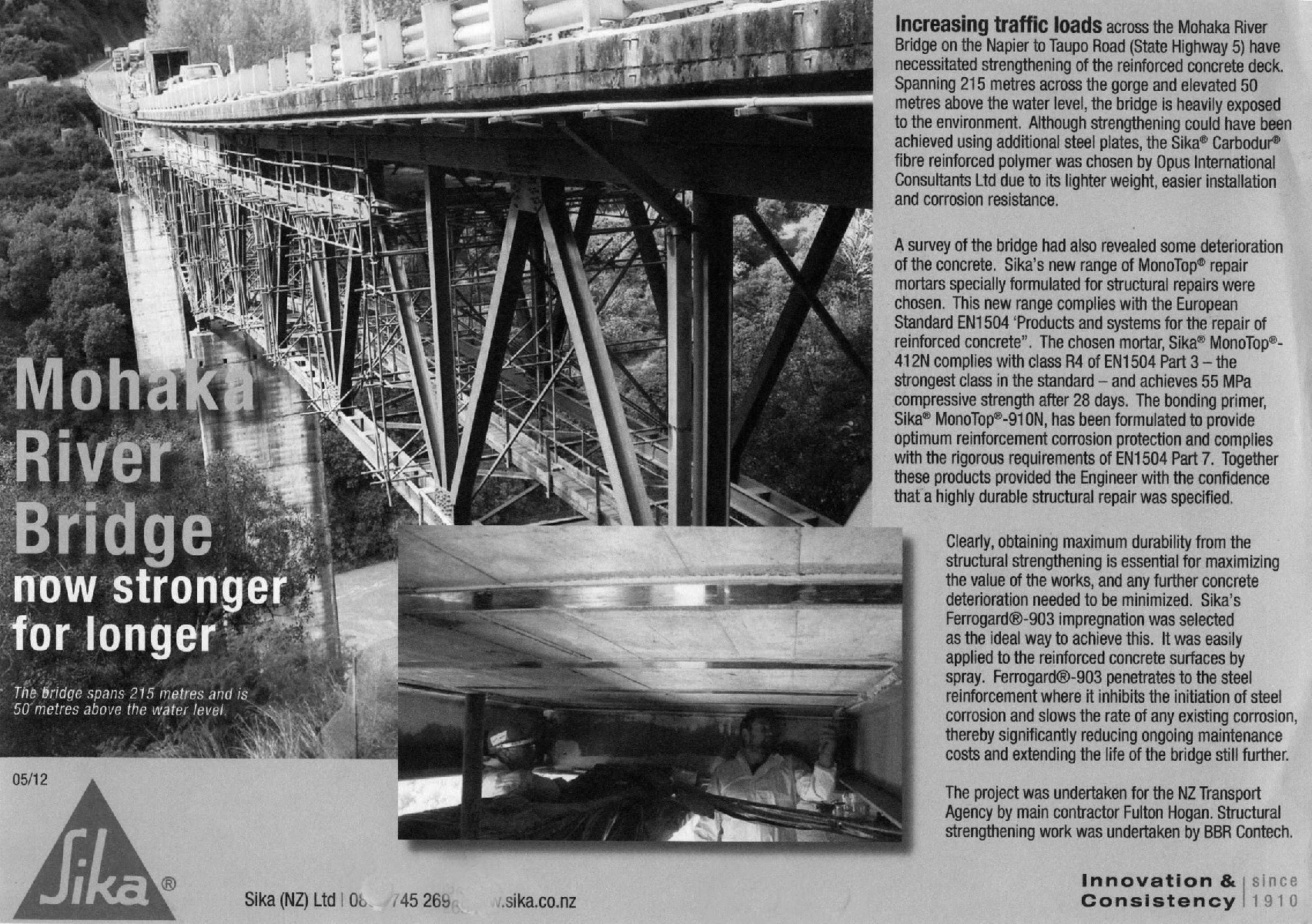
Mohaka River Bridge
now stronger for longer
The bridge spans 215 metres and is 50 metres above the water level.
Increasing traffic loads across the Mohaka River Bridge on the Napier to Taupo Road (State Highway 5) have necessitated strengthening of the reinforced concrete deck. Spanning 215 metres across the gorge and elevated 50 metres above the water level, the bridge is heavily exposed to the environment. Although strengthening could have been achieved using additional steel plates, the Sika® Carbodur® fibre reinforced polymer was chosen by Opus International Consultants Ltd due to its lighter weight, easier installation and corrosion resistance.
A survey of the bridge had also revealed some deterioration of the concrete. Sika’s new range of MonoTop® repair mortars specially formulated for structural repairs were chosen. This new range complies with the European Standard EN1504 ‘Products and systems for the repair of reinforced concrete”. The chosen mortar, Sika® MonoTop® – 412N complies with class R4 of EN1504 Part 3 – the strongest class in the standard – and achieves 55 MPa compressive strength after 28 days. The bonding primer, Sika® MonoTop®-910N, has been formulated to provide optimum reinforcement corrosion protection and complies with the rigorous requirements of EN1504 Part 7. Together these products provided the Engineer with the confidence that’s highly durable structural repair was specified.
Clearly, obtaining maximum durability from the structural strengthening is essential for maximizing the value of the works, and any further concrete deterioration needed to be minimized. Sika’s Ferrogard®-903 impregnation was selected as the ideal way to achieve this. It was easily applied to the reinforced concrete surfaces by spray. Ferrogard®-903 penetrates to the steel reinforcement where it inhibits the initiation of steel corrosion and slows the rate of any existing corrosion, thereby significantly reducing ongoing maintenance costs and extending the life of the bridge still further.
The project was undertaken for the NZ Transport Agency by main contractor Fulton Hogan. Structural strengthening work was undertaken by BBR Contech.
Sika (NZ) Ltd
Innovation & Consistency since 1910

MAORI WARS : THE HAU HAU WARS 1864 -72.
(SOURCE: The NZ Wars: A History of the Maori Campaign and Pioneering Period: Volume II).
(Chapter 34) : Posts on the Napier-Taupo Road.
Te Haroto – fifty four miles from Taupo (87 kilometres) and 50 miles (80 kilometres) from Napier. (The Ngati-Hineuru Tribe). A blockhouse had been erected earliest than the posts already mentioned. of 1869. This post was a square building with an upper storey projecting 2 – 3 feet over the lower building. A deep well was dug inside the blockhouse. The position was a commanding one, with a panorama of the mountainous country for many miles (kilometres) around. A mile away (1.609 kilometres) is the highest point on the Napier -Taupo Road, Tupurupuru 2,980 feet (909 meters) on the Turangakumu Range.
Te Haroto – Te Haroto Station homestead was originally built above the Mohaka River on flat land later known as “Mad Mile” and later shifted up, near to the Military Blockhouse at Te Haroto. The run carried about 14,000 head of sheep. Photo 1900.

MAORI WARS : THE HAU HAU WARS 1864 -72.
(SOURCE: The NZ Wars: A History of the Maori Campaign and Pioneering Period: Volume II).
(Chapter 34) : Posts on the Napier – Taupo Road.
Te Haroto – fifty four miles from Taupo (87 kilometres) and 50 miles (80 kilometres) from Napier. (The Ngati-Hineuru Tribe). A blockhouse had been erected earliest than the posts already mentioned. of 1869. This post was a square building with an upper storey projecting 2 – 3 feet over the lower building. A deep well was dug inside the blockhouse. The position was a commanding one, with a panorama of the mountainous country for many miles (kilometres) around. A mile away (1.609 kilometres) is the highest point on the Napier -Taupo Road, Tupurupuru 2,980 feet (909 meters) on the Turangakumu Range.
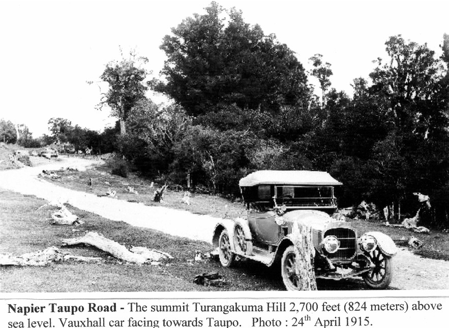
Napier Taupo Road – Te Haroto Native Village. View towards Taupo & Turangakuma [Turangakumu] Hill. (Skyline)
Note : Napier Taupo Road at right climbing towards Turangakuma summit. Photo 24th April 1915.

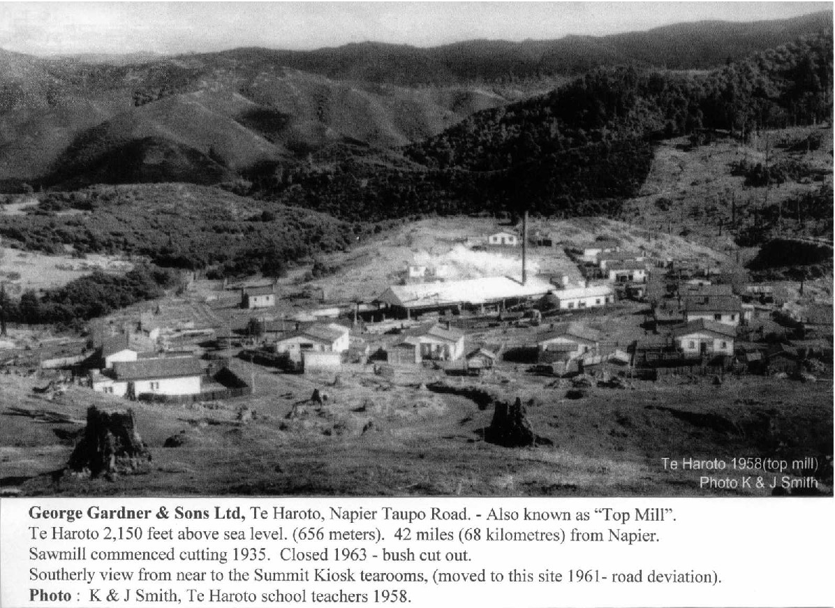
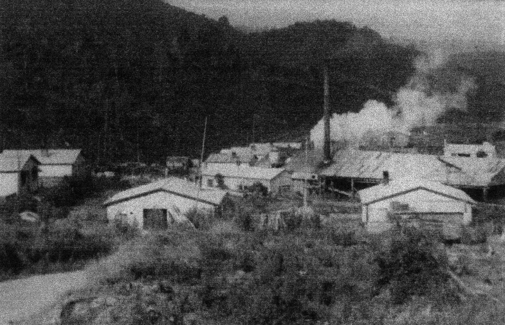
George Gardner & Sons Ltd, Te Haroto, Napier Taupo Road. – Also known as “Top Mill”.
Te Haroto 2,150 feet above sea level. (656 meters). 42 miles (68 kilometres) from Napier.
Sawmill commenced cutting 1935. Closed 1963 – bush cutout.
Southerly view from near to the Summit Kiosk tearooms, (moved to this site 1961- road deviation).
Photo : K & J Smith, Te Haroto school teachers 1958.
Te Haroto 1858 (top mill)
Photo K & J Smith

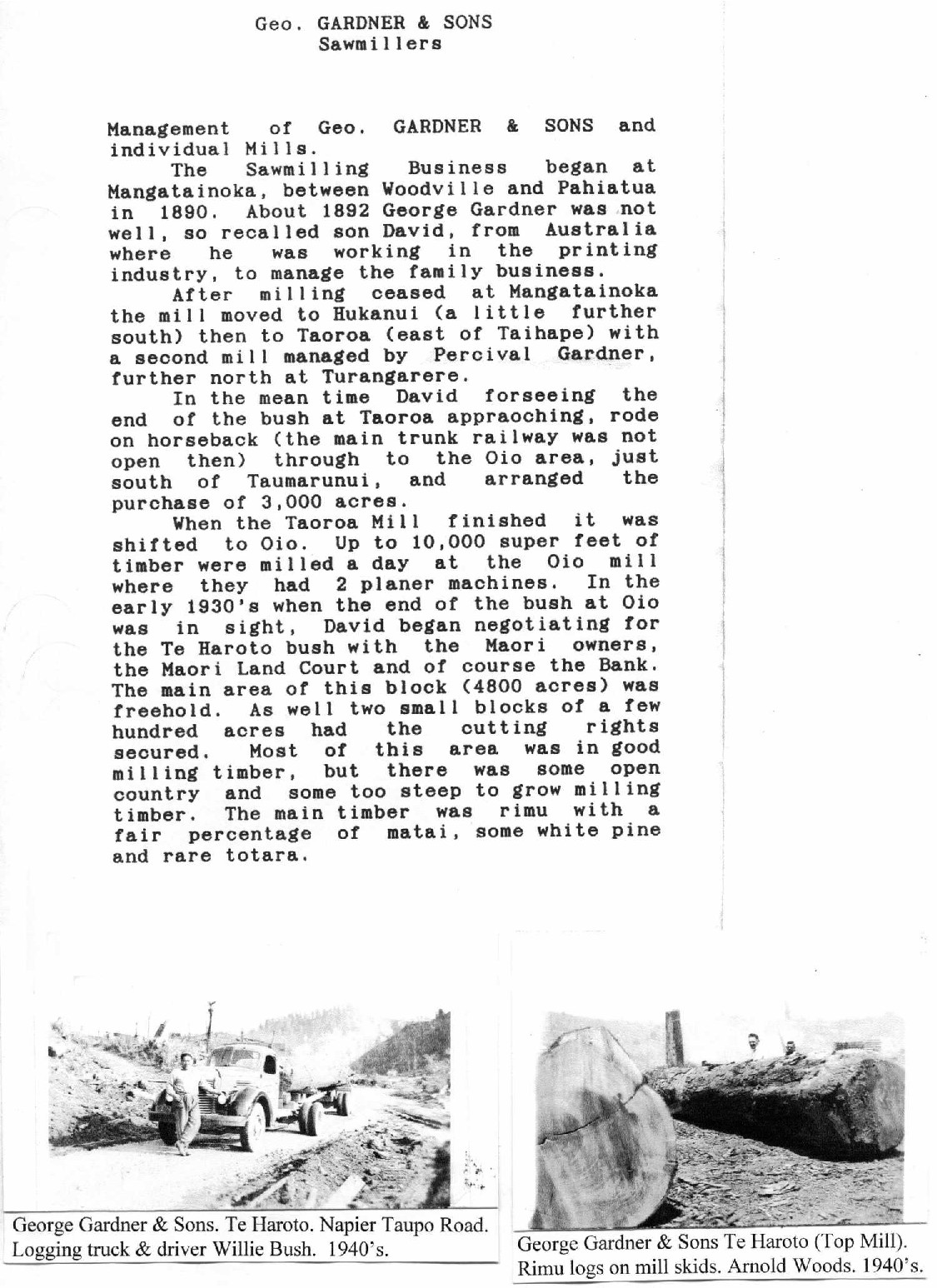
Geo. GARDNER & SONS
Sawmillers
Management of Geo. GARDNER & SONS and individual Mills.
The Sawmilling Business began at Mangatainoka, between Woodville and Pahiatua in 1890. About 1892 George Gardner was not well, so recalled son David, from Australia where he was working in the printing industry, to manage the family business.
After milling ceased at Mangatainoka the mill moved to Hukanui (a little further south) then to Taoroa (east of Taihape) with a second mill managed by Percival Gardner. further north at Turangarere.
In the mean time David forseeing the end of the bush at Taoroa approaching, rode on horseback (the main trunk railway was not open then) through to the Oio area, just south of Taumarunui, and arranged the purchase of 3.000 acres.
When the Taoroa Mill finished it was shifted to Oio. Up to 10,000 super feet of timber were milled a day at the Oio mill where they had 2 planer machines. In the early 1930’s when the end of the bush at Oio was in sight, David began negotiating for the Te Haroto bush with the Maori owners, the Maori Land Court and of course the Bank. The main area of this block (4800 acres) was freehold. As well two small blocks of a few hundred acres had the cutting rights secured. Most of this area was in good milling timber, but there was some open country and some too steep to grow milling timber. The main timber was rimu with a fair percentage of matai, some white pine and rare totara.
George Gardner & Sons Te Haroto. Napier Taupo Road. Logging truck & driver Willie Bush. 1940’s
George Gardner & Sons Te Haroto (Top Mill). Rimu logs on mill skids. Arnold Woods. 1940’s.

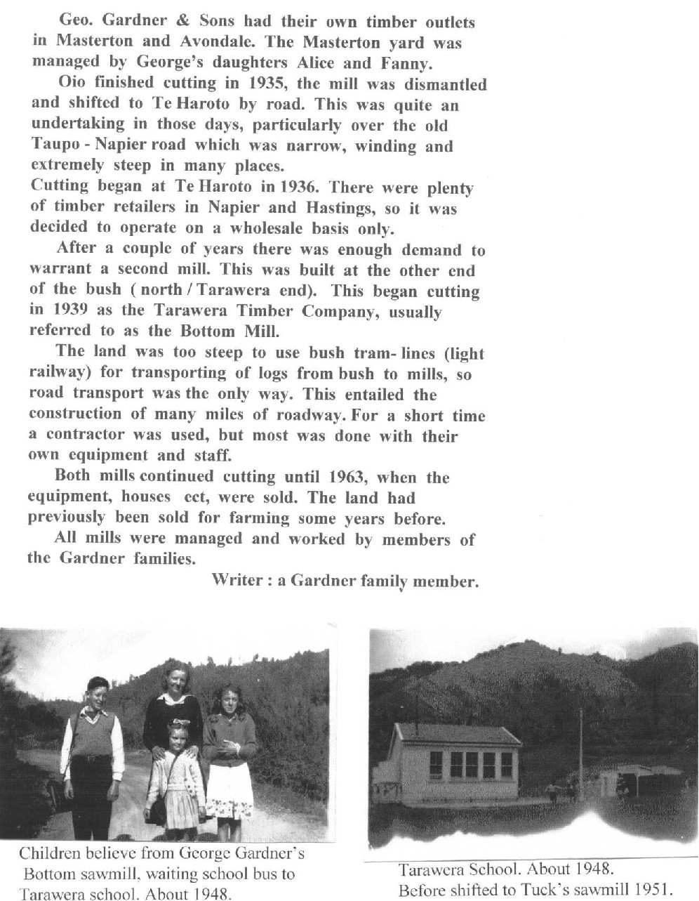
Geo. Gardner & Sons had their own timber outlets in Masterton and Avondale. The Masterton yard was managed by George’s daughters Alice and Fanny.
Oio finished cutting in 1935, the mill was dismantled and shifted to Te Haroto by road. This was quite an undertaking in those days, particularly over the old Taupo-Napier road which was narrow, winding and extremely steep in many places.
Cutting began at Te Haroto in 1936. There were plenty of timber retailers in Napier and Hastings, so it was decided to operate on a wholesale basis only.
After a couple of years there was enough demand to warrant a second mill. This was built at the other end of the bush (north/Tarawera end). This began cutting in 1939 as the Tarawera Timber Company, usually referred to as the Bottom Mill.
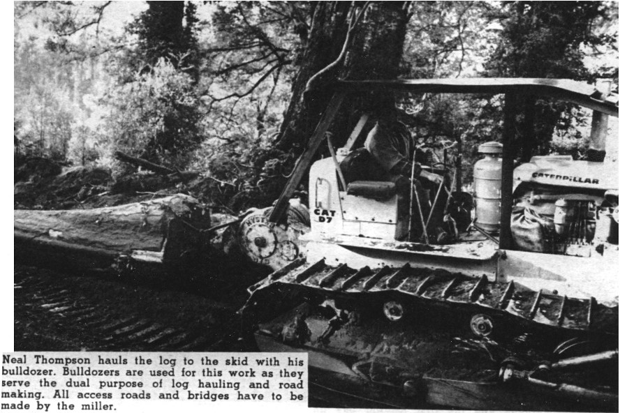
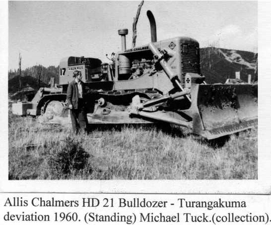
The land was too steep to use bush tram-lines (light railway) for transporting of logs from bush to mills, so road transport was the only way. This entailed the construction of many miles of roadway. For a short time a contractor was used, but most was done with their own equipment and staff.
Both mills continued cutting until 1963, when the equipment, houses ect [etc]. were sold. The land had previously been sold for farming some years before.
All mills were managed and worked by members of the Gardner families.
Writer : a Gardner family member
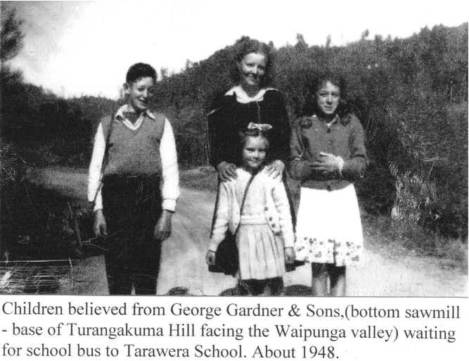
Children believe[d] from George Gardner’s Bottom sawmill, waiting school bus to Tarawera school. About 1948.
Tarawera school. About 1948. Before shifted to Tuck’s sawmill 1951.

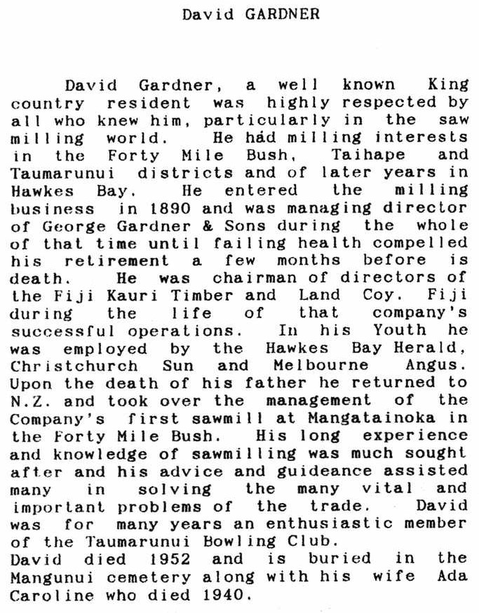
David GARDNER
David Gardner, a well known King country resident was highly respected by all who knew him, particularly in the saw milling world. He had milling interests in the Forty Mile Bush, Taihape and Taumarunui districts and of later years in Hawkes Bay. He entered the milling business in 1890 and was managing director of George Gardner & Sons during the whole of that time until failing health compelled his retirement a few months before is death. He was chairman of directors of the Fiji Kauri Timber and Land Coy. Fiji during the life of that company’s successful operations. In his Youth he was employed by the Hawkes Bay Herald, Christchurch Sun and Melbourne Angus. Upon the death of his father he returned to N.Z. and took over the management of the Company’s first sawmill at Mangatainoka in the Forty Mile Bush. His long experience and knowledge of sawmilling was much sought after and his advice and guideance assisted many in solving the many vital and important problems of the trade. David was for many years an enthusiastic member of the Taumarunui Bowling Club. David died 1952 and is buried in the Mangunui cemetery along with his wife Ada Caroline who died 1940.
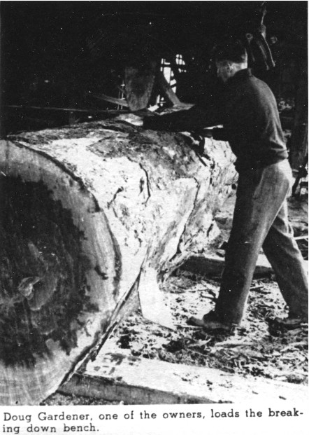


BACK COUNTRY TIMBER MILL
A major industry in New Zealand is the milling of our native and exotic forests; timber plays a very large part in our lives despite the ever increasing competition from plastics and suchlike. This picture feature shows the working of a back country mill which is situated at
Te Haroto on the Taupo Road and will very shortly close after a period of twenty-seven years of continuous work cutting native timber at the rate of 2,000,000 board feet a year. Mills such as this often working in difficult country, do contribute very largely to our economy.
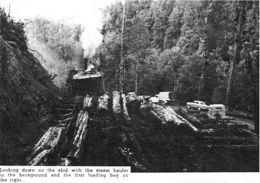
The start of a log on its journey to the mill. George Alexander clears an obstruction as the log is hauled from a gully.


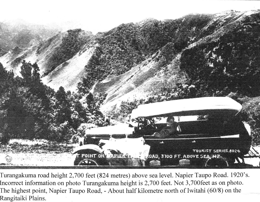
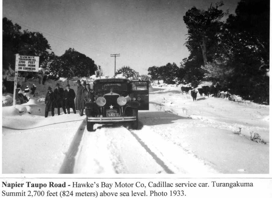
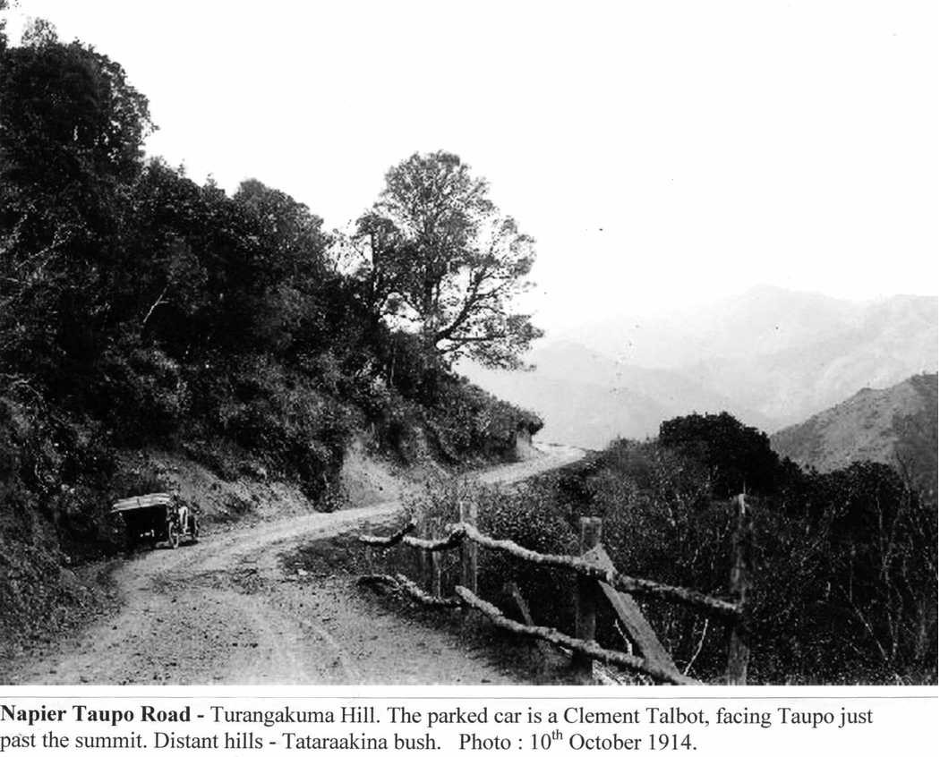
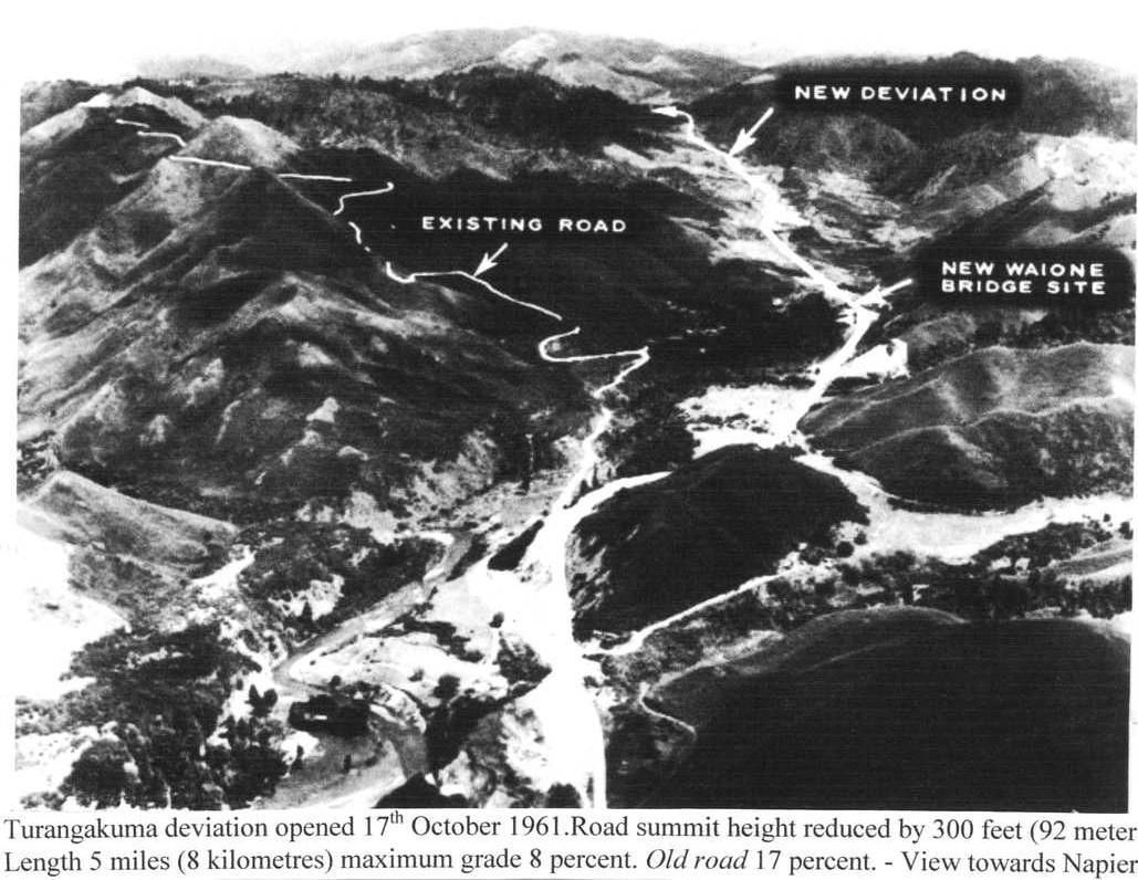
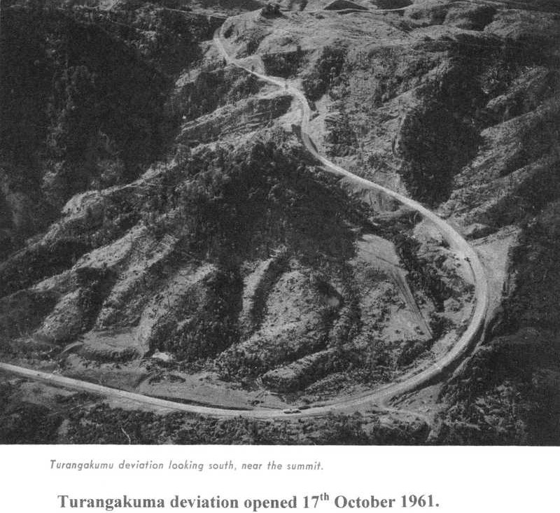
Turangakuma road height 2,700 feet (824 metres) above sea level. Napier Taupo Road. 1920’s.
Incorrect information on photo Turangakuma height is 2,700 feet. Not 3,700 feet as on photo. The highest point, Napier Taupo Road, – About half kilometre north of Iwitahi (60/8) on the Rangitaiki Plains.
TOURIST SERIES. 8024
HIGHEST POINT ON NAPIER-TAUPO ROAD, 3700 FT. ABOVE SEA, NZ


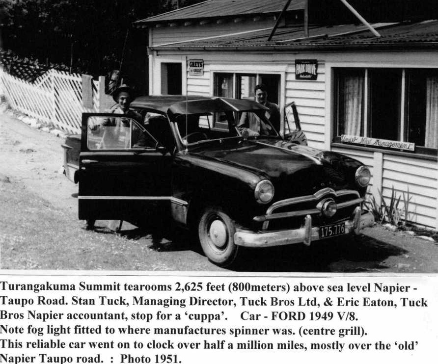
Turangakuma Summit tearooms 2,625 feet (800 meters) above sea level Napier – Taupo Road. Stan Tuck, Managing Director, Tuck Bros Ltd, & Eric Eaton, Tuck Bros Napier accountant, stop for a ‘cuppa’. Car – FORD 1949 V/8.
Note fog light fitted to where manufactures spinner was. (centre grill).
This reliable car went on to clock over half a million miles, mostly over the ‘old’ Napier Taupo road. : Photo 1951.
Car number plate 175.776

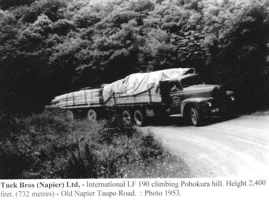
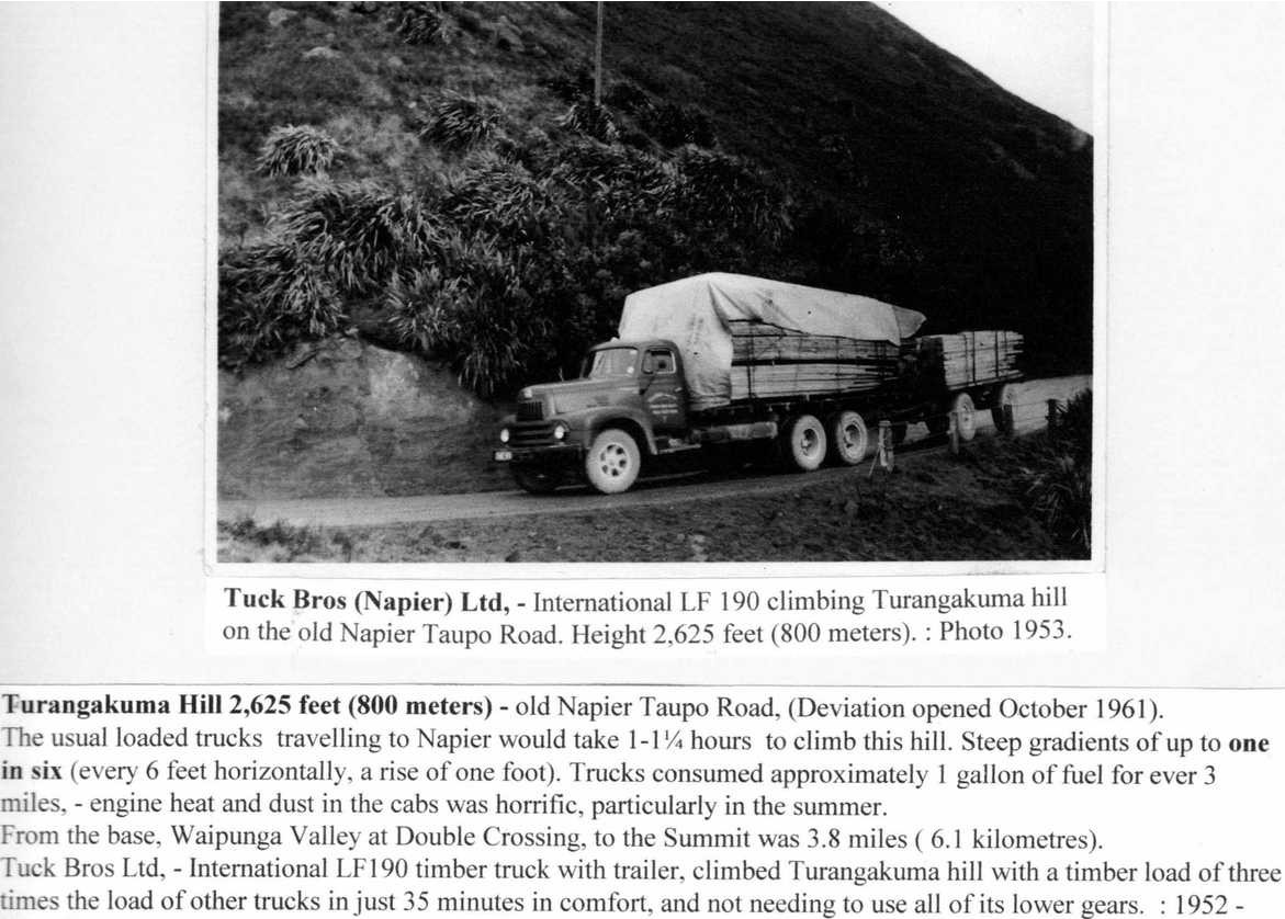
Tuck Bros (Napier) Ltd, – International LF 190 climbing Turangakuma hill on the old Napier Taupo Road. Height 2,625 feet (800 meters). : Photo 1953.
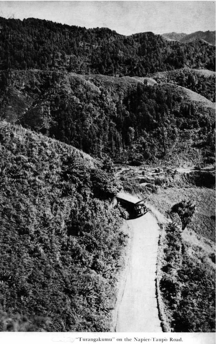
Turangakuma Hill 2,625 feet (800 meters) – old Napier Taupo Road, (Deviation opened October 1961). The usual loaded trucks travelling to Napier would take 1-1 ¼: hours to climb this hill. Steep gradients of up to one in six (every 6 feet horizontally, a rise of one foot). Trucks consumed approximately 1 gallon of fuel for ever [every] 3 miles. – engine heat and dust in the cabs was horrific, particularly in the summer. From the base, Waipunga Valley at Double Crossing, to the Summit was 3.8 miles (6.1 kilometres). Tuck Bros Ltd, – International LF190 timber truck with trailer, climbed Turangakuma hill with a timber load of three times the load of other trucks in just 35 minutes in comfort, and not needing to use all of its lower gears. : 1952 –

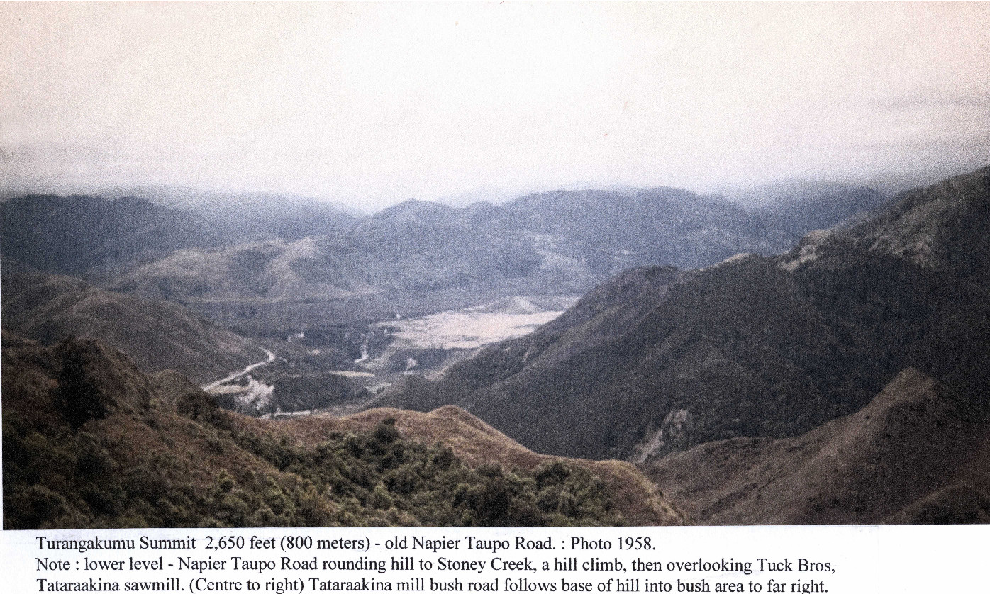
Turangakumu Summit 2,650 feet (800 meters) – old Napier Taupo Road. : Photo 1958.
Note : lower level – Napier Taupo Road rounding hill to Stoney Creek, a hill climb, then overlooking Tuck Bros Tataraakina sawmill. (Centre to right) Tataraakina mill bush road follows base of hill into bush area to far right.


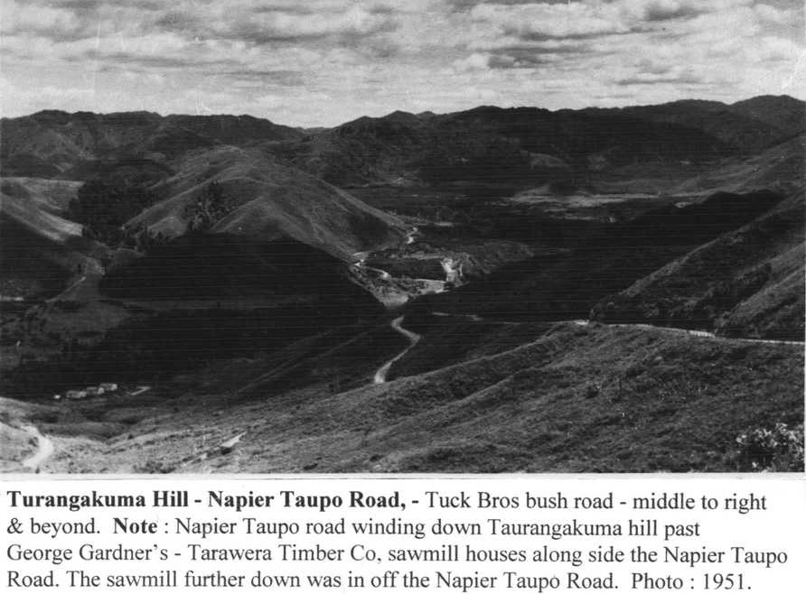
Turangakuma Hill – Napier Taupo Road, – Tuck Bros bush road – middle to right & beyond. Note : Napier Taupo road winding down Taurangakuma hill past George Gardner’s – Tarawera Timber Co, sawmill houses along side the Napier Taupo Road. The sawmill further down was in off the Napier Taupo Road. Photo : 1951.


Hawke’s Bay Motor Co. bus coming down Turangakumu Hill. Note : Gardner’s Sawmill houses – left middle of photo. : March 1953.
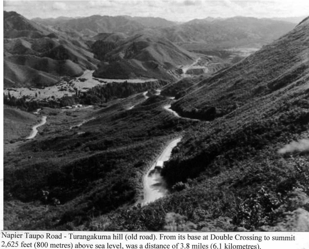
Napier Taupo Road – Turangakuma hill (old road). From its base at Double Crossing to summit 2,625 feet (800 metres) above sea level, was a distance of 3.8 miles (6.1 kilometres).


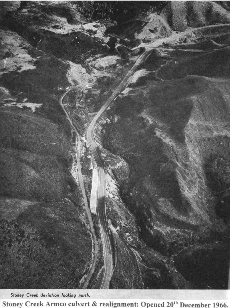
Downer & Co Wellington : contractors. Stoney Creek – Napier Taupo Road – Armco culver (22 foot diameter – largest Armco culvert in NZ) and road alignment. : Photo 2nd February 1966.
Other Stoney Creek Armco culvert contract – Daily Telegraph Napier news paper reference – see September 13th 1966 : 29th October 1966 : 10th December 1966: 22nd February 1967.

BIGGEST IN N.Z
Improvements at Stoney Creek, on the Napier-Taupo highway, have been largely overshadowed by the magnitude of the Titiokura and Runanga deviations. Stoney Creek will, however, be the scene of the next new section of highway to be used by motorists.
The Titiokura deviation is completed. The Runanga deviation, on which work has already started, will not be opened to traffic inside three years.
CREEK DIVERTED
Stoney Creek, a short distance on the Napier side of Tarawera, is now a hive of activity as the contractor, Downer and Co. Ltd., pushes ahead with a three-quarter mile diversion.
The creek itself was last week diverted through a massive 22ft diameter steel culvert – the biggest of its kind in New Zealand, and probably in the southern hemisphere.
The project involves 300,000 cubic yards of earthworks and the new road level will be 52 feet higher than the creek-bed.
Mr R. D. Grant, Ministry of Works resident engineer at Napier, said today that the Stoney Creek work was going ahead well.
THIS SUMMER
“Traffic should be using it this Summer,” he said. “Sealing should be well under way by Christmas.”
To close the gap between Downer’s work at Stoney Creek and the Tarawera camp, the existing road will be strengthened and sealed “as is.”
Grades will be of the order of one in 10 (slightly steeper than the Titiokura. deviation) and the alignment will be comfortable for speeds of 35 to 40 m.p.h.
STONEY CREEK trickles into the mouth of the massive steel culvert which has been completed in the Napier-Taupo road. The creek was diverted last week from its original bed which the bulldozer (right) is filling in. The carry-all above the culvert is dumping material which will eventually rise to a level of 52 feet above the creek bed.
DAILY TELEGRAPH Napier, 20th December 1966.


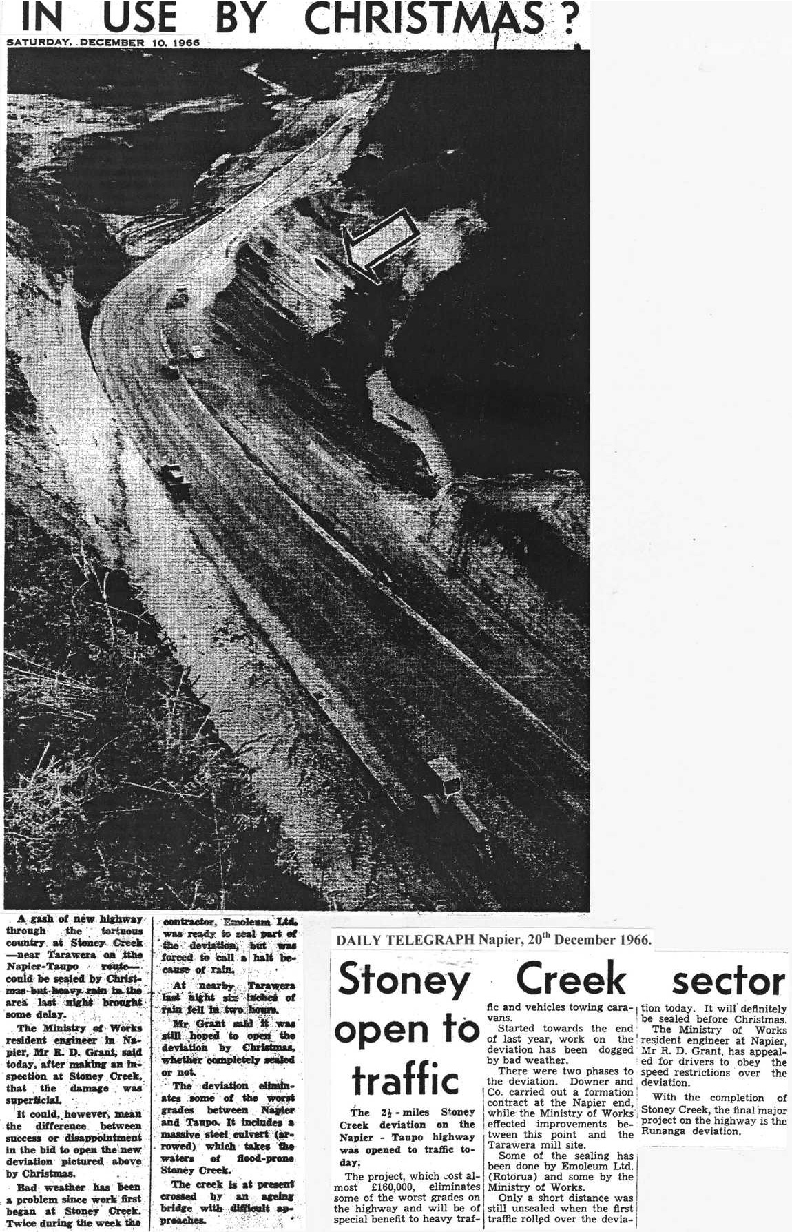
IN USE BY CHRISTMAS?
SATURDAY, DECEMBER 10, 1966
A gash of new highway through the tortuous country at Stoney Creek – near Tarawera on the Napier-Taupo route – could be sealed by Christmas but heavy rain in the area last night brought some delay.
The Ministry of Works resident engineer in Napier, Mr R.D. Grant, said today, after making an inspection at Stoney Creek, that the damage was superficial.
It could, however, mean the difference between success or disappointment in the bid to open the new deviation pictured above by Christmas.
Bad weather has been a problem since work first began at Stoney Creek. Twice during the week the contractor, Emoleum Ltd. was ready to seal part of the deviation, but was forced to call a halt because of rain.
At nearby Tarawera last night six inches of rain fell in two hours.
Mr Grant said it was still hoped to open the deviation by Christmas, whether completely sealed or not.
The deviation eliminates some of the worst grades between Napier and Taupo. It includes a massive steel culvert (arrowed) which takes the waters of flood-prone Stoney Creek.
The creek is at present crossed by an ageing bridge with difficult approaches.
DAILY TELEGRAPH Napier, 20th December 1966.
Stoney Creek sector open to traffic
The 2½-miles Stoney Creek deviation on the Napier-Taupo highway was opened to traffic today.
The project, which cost almost £160,000, eliminates some of the worst grades on the highway and will be of special benefit to heavy traffic and vehicles towing caravans.
Started towards the end of last year, work on the deviation has been dogged by bad weather.
There were two phases to the deviation. Downer and Co. carried out a formation contract at the Napier end, while the Ministry of Works effected improvements between this point and the Tarawera mill site.
Some of the sealing has been done by Emoleum Ltd. (Rotorua) and some by the Ministry of Works.
Only a short distance was still unsealed when the first traffic rolled over the deviation today. It will definitely be sealed before Christmas.
The Ministry of Works resident engineer at Napier, Mr R.D. Grant, has appealed for drivers to obey the speed restrictions over the deviation.
With the completion of Stoney Creek, the final major project on the highway is the Runanga deviation.

Original digital file
TuckMP1085_SH5_Titiokura_StoneyCreek.pdf
Non-commercial use

This work is licensed under a Attribution-NonCommercial 3.0 New Zealand (CC BY-NC 3.0 NZ).
Commercial Use
Please contact us for information about using this material commercially.Can you help?
The Hawke's Bay Knowledge Bank relies on donations to make this material available. Please consider making a donation towards preserving our local history.
Visit our donations page for more information.
Description
More items in this collection will be added in due course
Other surnames in this folder – Burke, Haines, McGrath
Tags
Format of the original
Folder of photocopied photos and typed textDate published
2016People
- George Alexander
- B Broughton
- Willie Bush
- Ken Charlton
- James Dobbs
- Merv Doidge
- Patrick Dooney
- S Drinkrow
- Mark Dunnett
- Eric Eaton
- Ada Caroline Gardner
- David Gardner
- Doug Gardner
- George Gardner
- J Gerrard
- Dan Gilbert
- R D Grant
- Paul Hodgson
- J B Holland
- J B S Huizing
- Monty Kahukiwa
- A I Kennard
- W J Keough
- Joseph King
- Edward Newbigin
- Bill Ringi
- Dan Smith
- K & J Smith
- S Percy Smith
- Neal Thompson
- Stanley Palmer Tuck
- Andrew Turnbull
- Arnold Wood/Woods
Accession number
455140Supporters and sponsors
We sincerely thank the following businesses and organisations for their support.


Do you know something about this record?
Please note we cannot verify the accuracy of any information posted by the community.