Te Waka Range Trip 2000
TE WAKA RANGE, TE POHUE
HASTINGS No 11 SQUADRON AIR TRAINING CORP
18 to 20 AUGUST 2000
Friday: We waited at the turnoff for the MOG with it’s human cargo and trailer full of packs and tents to arrive so that we could convoy through the series of gates to Awhina hut. The vehicle eventually arrived from the direction of Taupo, the driver overshooting the turnoff due to reconfiguration of the highway and having to go on a few more kilometres where an about-face could be made without the trailer becoming a traffic hazard.
The sergeant and her corporals soon had the trailer unloaded and tents being put up by willing cadets, pleased to be breathing the wonderful country air rather than diesel fumes. Putting tents up in the black of night by torch light was made easier by those who had “been there, done that” at camps in earlier years. Before taking up occupancy, the troops were given the normal advice about hazards in the area, hygiene and safe behaviour in the outdoors including the benefits of keeping a dry set of clothes and wearing warm hat. Friday’s weather had been kind up until now although the Southern Cross was indifferent as to whether it was able to be seen or not.
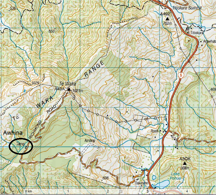
Saturday: The cadets divided into two groups. The first group walked from camp to the trig and microwave station in the morning, the second group traveling over the same ground in the afternoon. The only difference being that the low cloud causing whiteout conditions in the morning, had blown away by afternoon providing great views from Mahia peninsular to Cape Kidnappers on the coast to the Wakarara and Ruahine ranges inland. It was about this time that Evan had to stick a new set of batteries in his GPS global positioning system. By the time you sort out which screen you should be using and allowed the height above sea-level to sort itself out, maybe it’s short for “going places shortly”. No feral kittens brought out of the bush like ATC Napier’s weekend in May, but we did see a small mob of goats on a distant ridge and Mr. France’s keen eyes spotted a hare below the cliffs surrounding the trig. We learned the names of a few trees on the way, ti kouka or cabbage tree, horopito or pepperwood, mountain totara, beech and manuka and a few birds, heard but not often seen, bellbird, tomtit, grey warbler, yellow-hammer, finches and magpies. Ruru the morepork was absent Saturday night that wise old owl new it was going to rain and must have stayed in bed.
Sunday: A soggy morning saw most cooking breakfast under the cover of the lean-to. With the cadets in their groups from the previous day, the exercise was to pool each person’s memories of the terrain traveled to the trig and produce a map of the area. In the next stage, the two groups came together to combine the two maps and produce one final map. Gemma volunteered to be chief topographer and buried her head in the work while onlookers gave advice on spot heights, distances to prominent features, where to mark ridges, streams and saddles. I kept this map, promising to compare it to that section of map V20 Esk and let them all know how accurate it was.
The weather was making an effort to improve and tents were packed away almost dry. While they waited for the transport to arrive some keen cadets went with Daniel, Net and Fiona to try navigating a triangular course in the bush near camp. By counting an equal number of steps and traveling on a magnetic bearing as accurately as possible, they proved that they could arrive back where they started, well, plus or minus a few metres anyway! And it was fun trying.
We were a little late back to Headquarters, but hey, we had had a ball and learned a few things too! But wait, there’s more. Back at work that week, I made the photocopier do its thing and enlarged map V20 and the Te Waka range to a size similar to that drawn by the cadets. AMAZING! When overlapped and held up to the light, 90% of the features fitted together like a hand in a glove. I was impressed! If only we could show this on an overhead projector on acetate the effect would be more easily seen. On parade night, Mr. France was able to oblige with both of the above and I congratulated the cadets for a wonderful first attempt at mapping an area and producing such an accurate picture.
Thanks for a great weekend.
Rex Hoskin
BUSHCRAFT INSTRUCTOR

Original digital file
NewsonJR739-9_TeWakaRangeTrip2000.pdf
Non-commercial use

This work is licensed under a Attribution-NonCommercial 3.0 New Zealand (CC BY-NC 3.0 NZ).
Commercial Use
Please contact us for information about using this material commercially.Can you help?
The Hawke's Bay Knowledge Bank relies on donations to make this material available. Please consider making a donation towards preserving our local history.
Visit our donations page for more information.
Subjects
Business / Organisation
Hastings Number 11 Squadron Air Training CorpFormat of the original
Computer documentDate published
18-20 August 2000Accession number
593035Supporters and sponsors
We sincerely thank the following businesses and organisations for their support.


Do you know something about this record?
Please note we cannot verify the accuracy of any information posted by the community.