Historical Geography of a Hawke’s Bay Region, An

TABLE OF CONTENTS.
Introduction
CHAPTER I Hawke’s Bay about 1840
CHAPTER II Origins of European Settlement Part I – Whalers, Traders, Missionaries
CHAPTER III Origins of European Settlement part II – Origins of pioneer grazing
CHAPTER IV Hawke’s Bay about 1856
CHAPTER V Expansion of settlements during and after Provincial Government 1860-1880
CHAPTER VI Hawke’s Bay about 1890
CHAPTER VII Conclusion
APPENDIX A Vegetation and human occupance
APPENDIX B Separation of the H. B. District from the Province of Wellington
APPENDIX C The Founding of Hastings
APPENDIX D Floods and river control
BIBLIOGRAPHY
MAPS PAGE
1. Location 2
2. Locality Map 5
3. pre European vegetation and drainage 7
4. Mean Annual Rainfall in inches 9
5. Surface configuration 11
6. Maori Pa Sites 12
7. Some of the Native Land Purchases to 1860 38
8. Distribution of Population 1856 43
9. Development of Napier 48
10. Heretaunga Plains 1864 66
11. Subdivision of the Heretaunga Block 1869 68
12. Subdivision pattern 1890 81
13. Land use pattern 1890 89
Introduction.
One of the most widely adopted of the various approaches to historical geography is the reconstruction of past geographies at various periods in time. Some geographers believe that a study of changing landscapes is more satisfying. In this thesis an attempt has been made to combine these two different methods of approach to historical geography, in a region of Hawke’s Bay. The emphasis has been laid on areal description of the landscape at three different dates, 1840, 1856 and 1890. The descriptions do not refer exactly to these three dates, for some of the source material precedes or follows after these dates, hence the titles “Hawke’s Bay about 1840′, or ‘1856’. As far as possible data relating to these three dates has been used. In the three intervening chapters, stress has been laid on factors and events such as changes in land tenure and sheep breeding, political changes and other phenomena that have caused changes in the landscape, distribution of population, communications and size and distribution of farms. Though no attempt has been made to continue these period studies beyond 1914, conclusions have tried to be drawn relating to the human occupance of the land at these three different periods.
For source material and data generally, the main problems encountered were the lack of survey maps during the Provincial Government period and statistics of pastoral production in the late 1850’s to the mid 1870’s. Much reliance has been placed on newspaper reports and correspondence, as much of Hawke’s Bay has been neglected in historical literature, possibly because of a lack of early survey records, maps and official correspondence.
Acknowledgements.
I am greatly indebted to Mr. J. G. Wilson, of Hatuma, who kindly lent much rare material and who offered helpful criticism when reading the text. Mr. A. I. Rainbow and Mr. R. N. Bell, of Hastings, also gave valuable help with material from time to time. Thanks are due also to members of the
staff of the Hastings Public Library and the Hawke’s Bay Museum and Art Gallery, Napier, for placing much heterogeneous material at my disposal, and special thanks to Miss Phillips and Miss A. E Woodhouse of the museum staff for typing extracts from Colenso’s Journal, ‘In Memorium’. The Land and Survey Department, and the Ministry of Works in Napier also gave much assistance with copying of early maps and Plans. Thanks are also due to the staffs of the General Assembly and Alexander Turnbull Libraries in Wellington for the use of New Zealand Company Archives and Provincial Government reports, papers and manuscripts. Grateful acknowledgement is made also to Mr. N. L. Elder, of Havelock North, Mr. J. L. Porter and Mr. P. J. Grant and the Aerial Mapping Company who kindly lent photo negatives for printing and who gave advice and materials. Finally thanks are due to the staff members at the Christchurch Public Library and the University of Canterbury Library for assistance in every way. Also a special mention of thanks for Mrs. Oliff who so kindly and painstakingly typed out this thesis. Thanks, too, are due to numbers of other people who provided statistics and printed material; acknowledgement of source material appears in footnotes and alongside photographs throughout the text.
It should be added that this thesis is not intended to be a comprehensive summary of the growth of farming or of land development of this region. More material will need to be uncovered before this is possible. The growth of the region has been unplanned, gradual and evolutionary rather than revolutionary. There were no sudden gold rushes, prolonged native strife or quick emergence of a distinctive ‘regional consciousness’ that has characterised the growth of other regions of New Zealand.

ADDENDA
“Ahuriri” was the term commonly used by traders, whalers and settlers before 1858. When the Wairarapa and Hawke’s Bay electoral districts were divided in 1856, the northern district of ‘Hawke’s Bay’ was called ‘Ahuriri’. When the Province was proclaimed in 1858, the title of ‘Hawke’s Bay’ was retained and the name ‘Ahuriri’ was used for the port.
The title ‘Heretaunga Plains’ came to displace ‘Ahuriri Plains’ by 1870, though the two terms were, until then, used interchangeably.

CHAPTER I
Hawke’s Bay about 1840 – The Pre-European. Landscape and occupance.
A. The setting.
Hawke’s Bay, located on the middle east coast of the North Island, presented a varied, complex and rather unpromising environment to both Maori and European. Flanked to the west by rugged, often precipitous mountain ranges, the easier, rolling foothills gave way to the tidal bound, alluvial Ahuriri plains. To the east lay a dissected, gently folded series of hills with two limestone promontories at Te Mata (1320 feet) and Kahuranaki (2117 feet). On the northern edge of the plains, the western foothills gave way to a more rugged, steeper and complex group of hills and valleys that reached the coastline in a number of rocky, boulder strewn cliffs. Smaller alluvial valleys lay interspersed with these cliffs, formed from swift flowing degrading rivers.
The triangular shaped plains lay enclosed by these two uplifted and unstable blocks; the western ranges and foothills and the coastal hills. Infilling of this graben like depression into an alluvial plain was due to the action of the three major rivers, the Tutaekuri, Ngaruroro and Tukituki. Bringing deposits of coarse pumice down from the barren wastes of the Taupo- Rotorua plains, the Tutaekuri entered the depression near Waiohiki and followed a sluggish plains course before emptying into the marine-filled Inner Harbour (Te Whanganui-a-Orotu). The Ngaruroro river also carried deposits of pumice and ash from the fringes of the Taupo plains through the precipitous gullies and ravines of the Ruahine and Kaweka ranges eastwards to the plains where it entered at Fernhill. Skirting the

Page 2
shingle deposits of the Tukituki river near Te Mata, it also followed a more devious plains course before being joined by the Waitio stream near Pakowhai. 1 The Tukituki river in the early stages of its course formed large lake-like areas near Waipukurau and Waipawa before limestone blocks between Patangata and Te Mata were fractured, so enabling the river to take a northern course. No pumice deposits from the ash showers were carried by the river or its tributaries. Skirting the cuesta – like Havelock Hills to the west the river had a short, direct plains course before entering the bay at the south end of the flats. 2 In summer these rivers were slow flowing and silty: the heavy southerly-driven surf, together with the prevailing on-shore current, built up shingle ridges that caused the river mouths to change or become blocked. This phenomenon often occurred after a long summer drought or a severe easterly driven gale. In consequence of this unceasing struggle between sudden floods from the mountains and the powerful swell of the ocean, the Tutaekuri and the Ngaruroro rivers terminated in a large swampy lagoon behind the shingle ridge. The plains course of the Ngaruroro river has altered several times and the overflow from the river near Fernhill joined the overflow of the Tutaekuri near Redcliffs during heavy floods and over half the plains became a sea-like area. Prior to the building up of this area by the three rivers, the sea level rose after the Great Ice Age covered the coastal hills and plains as far west as Maraekakaho and Tunanui [Tuna Nui]. Small bays were etched out and an island formed at Roy’s Hill. Scinde Island became a limestone promontory separated entirely from the mainland. 3 The deposition of the shingle and pumice by ( words missing)
1 H. Hill; ‘Artesian-Water Basins of Heretaunga Plains’ Transactions, Vol.37. 1904. p431
2 H. Hill: Op. Cit. p.432
3 H. Hill: Op. Cit. p.435

Page 4
throughout the spring and summer seasons. The rolling foothills west of the Ruahine and Kaweka ranges are particularly affected by these gale force winds and the widespread distribution of the pumice and ash shower deposits was aided by these winds. 6 Rain bearing winds that blow from the east and south are accentuated by the high elevations of the country near the coast north of Napier and southeast of Hastings. Hastings receives an annual average rainfall of 32½-inches whereas the Maraetotara valley, near Waimarama, sometimes receives 70-inches. North of Napier the hills become steep and rugged, favouring an even higher rainfall. Situated between these two areas having an extreme rainfall, the plains experience rather unreliable rainfall throughout the year. Though dry conditions associated with the foehn – like nor.’westers prevail, heavy and erratic thunderstorms are likely. Frequent rather than heavy winter rains prevail, and occasional heavy frosts and dews accompany this winter rain. The influence of the sea upon diurnal and seasonal temperatures decreases inland; Napier has a winter temperature of 50 degrees Fahrenheit; a summer maximum of 67.3 degrees Fahrenheit. The range of temperature for Hastings is 20 degrees with a summer maximum of 65.4 degrees. At any time between November and March the barometer may soar to over 90 degrees at Hastings which is affected less than Napier by the tempering sea breezes and so lowering the relative humidity of the atmosphere. Associated with this unreliable rainfall and high annual temperatures, is the high number of frost-free days with Napier experiencing, on an average, 2,400 hours of sunshine and Hastings only 90.1 days of ground frost. 7 Therefore this sheltered sea-
6 H. Hill, Loc. Cit., p.440
7 Statistics from ‘Land Utilisation Report of the Heretaunga Plains. D. S. I. R. Bull., No. 70, 1939, p.15.


Page 5
bound region experiences a climate that was conducive to a sedentary pattern of farming which the Maori tribes brought from their island homeland.
B. Natural Vegetation.
As there are few detailed records available, it is not easy to describe the vegetation cover of Hawke’s Bay about 1840. Moreover, the Moa-hunter period of Maori culture cannot be separated with certainty from that of their usurpers.
However, climate and vegetation seem to be the chief factors governing the distribution of the pre-European vegetation cover.
1. Western ranges and foothills.
Along the lower slopes of the Ruahine range (to 3000 feet) and on the higher pumice lands of the Kaweka mountains, Podocarp forests was the dominate cover.
Rimu (Dacrydium cupressinum ) on the heavy soils, and Matai (Podocarp epicatus) on moderately drained slopes were the main species, and totara associations were found only in the drier areas.
Above 3200 feet Nothofagus forest appeared as the dominant forest association in these western ranges. Mountain beech (N.cliffortioides) flourished on the higher, exposed faces, while silver beech (N. fusca) were dominant lower down the slopes. On the same southern faces of the north-west pumice plateaux, areas of snow tussock (Festuca Novae-Zealandiae), snow grass (Danthonia flavescens) and mountain flax tended to replace the formerly forested slopes where the fog and the north limits of the timber line tends to scrub instead of timber. The Maori did not attempt to settle on the higher, beech forested lands. Such land was the habitat of the native kiwi and kiore, and as the Maori was a conservationist with his farming techniques, explanations other than mere bush burn have been advanced for the numerous patches of bracken fern and tussock found along the northern margins of these ranges. 8 Silver beech (N. Menziessi) was
8 See Appendix A

Page 6
Photo – J .L. Porter.
Snow tussock and low grassy plant cover in the headwaters of the Ngaruroro river. Altitude 4,500 ft
Photos – P. J. Grant
Mountain beech with snow grass in the near foreground, illustrating the reversion of forest cover to montane grass and low scrub, resulting from burning and depletion of cover by rabbits. Area, west of Wakarara ranges; altitude 4,200 feet.
Stunted gnarled cover on the crest of the wind swept southern Ruahine ranges. Montane grass, and Olearia numularifolia and other wind resistant species.

Page 7
absent due to heavy fogs and heavy rainfall, the species not being shade tolerant. On the Ruahines, the timberline between forest and tussock is very marked at approximately 4,200 feet. Further north, mountain beech was replaced by red beech on the drier, pumice blown soils, 9 and the transition between the timber and scrub was much less marked.
2. Coastal hills.
When the first white settlers came most of the hill country east of the podocarp forest appears to have been covered with a mixture of bracken fern, manuka and danthonia, with white pine (Podocarp kahikatea) swamp forest in gullies and clumps of cabbage trees on the seaward-facing slopes. The absence of dense stands of podocarp forest is striking; a contrast to the western and southern hills. It is not known what was the earlier cover replaced by bracken fern, manuka and danthania [danthonia] in the 1840’s, but it is unlikely that it was tall podocarp forest. The cover may have been broadbay forest, now confined to more fertile soils with a higher rainfall, (e.g. at Te Aute, Raukawa, Poukawa). On the limestone ridges especially, danthania [danthonia] grass and microlaena stipoides (rice grass) seems to have been most conspicuous.
3. Heretaunga Plains.
Lying between the western hills and the coastal hills lay the Heretaunga Plains, covering 93,320 acres, the only extensive region of flat land in the district. The plains, built of river sediments and to some extent by marine deposits when the sea level rose in Pleistocene times revealed a variety of swamp vegetation. The Pre-European vegetation then, was very largely swamp. Raupo (Typha augustifolia) was most widespread on silt swamps, rising in
9 N. Zotav [Zotov]: Same conditions [Some correlations] between vegetation and climate in N.Z. N.Z. Jour. Sci. and Tech. Jan, 1938, pp. 474-487.


Page 8
Photo – N. L. Elder
Mountain beech cover in the central Ruahine ranges. Mountain flax and scrub in foreground
Remnants of dense pockets of podocarp forest and light bush on the coastal hills south of Cape Kidnappers.
Solitary cabbage trees characterise much of the coastal country. Swampy cutting grass and danthonia with Yorkshire fog and ryegrass form much of the sheep pasture. Bare Island in the foreground (distance)


Colenso noted that this ‘view from the top on the Eastern and Northern sides was very extensive, extending from Cape Kidnappers to Table Cape, and thence to Mt. Tongariro (not in this picture). The whole of Hawke’s Bay with all its interior plains appeared like an immense panorama – but much too distant, low and flat and too dull in its colours – of musty fern and dingy Raupo, pale cutting grasses and dried withered plains with a lead coloured, misty-looking sea in the distance – to present anything of a pleasing appearance.’

Page 11
C. Native settlements.
Location.
The whole of the east coast of the North Island was, from the time of the great migration in 1350 onwards, a favoured area for Maori settlement. The warm, equable climate, forested foothills and swampy, grassy, alluvial plains were ideally suited to the Maori’s way of life. His mode of living was, of course, primarily subsistence; though intensive and specialised. For he was a skilled hunter and fisherman, with a variety of soil cultivation techniques that were best suited to a coastal, warm climate with a relatively gentle surface configuration, varied soils, dense stands of forest and an abundance of native fauna. Such a region was distinguished first by Cumberland in 1949 and later by G. R. Lewthwaite in 1950, and was so-named the ‘Iwitini’ region. The cultivation of subtropical food crops (the characteristic food being ‘kumera’) alone provided a major part of the Maori’s food needs. Ample rainfall and sunshine and a relatively low incidence of ground frosts created ideal conditions for this starchy plant. Foods that were gathered were chiefly the edible fern root, wild berries and tuberous plants growing along the fringes of mixed bush. It is doubtful whether taro or yams were cultivated in deep pits to any extent, due to the light frosts, though occasional harvests were possible. Apparently the Maori preferred to toil in light bush or scrub where he could pluck up the fern and shrubs and feed the rubbish into the fires, so increasing the burn necessary before tilling the soil. Best believes that the lack of good wood-cutting tools forced them to rely principally on fire in the clearing of the land. It is unlikely that the Maori sought systematically to clear virgin beech forests, a source of the kiwi and of wood for fuel and canoe building.
This pattern of settlement commenced over eight hundred years ago when the great Ngati- Kahungunu tribe under


Page 12
Tupurupuru (fourteenth in his line from Tai ? Who settled in New Zealand in 900 A. D.) migrated southwards from East cape in two main parties. 12 They settled on the swamps and lake edges, river outlets and forest margins, on the undulating plateaux and low-lying plains of Hawke’s Bay. Villages grew along river valleys and sea shores, on coastal swamps and fresh water lakes, where shell fish, crayfish, flounder, and eels and other sea and fresh water foods abounded. In the numerous rocky inlets and sandy bays along the coast between Mahia and Waimarama, Maori pa sites overlooking the sea were numerous. Inland, the eel, pukeko, native rats (in the podocarp forest) and duck were plentiful in the slow flowing tidal bound Ngaruroro and Tutaekuri rivers and in the coastal marshes. Here, as along the coast, near each tribal village a fortified ‘pa’ was erected on rising ground that was easily defensible where the tribesmen and their families could hastily retire to shelter. Supplies of wood and water nearly made many ‘pas’ self sufficient during frequent tribal wars.
Types of settlement.
On the hill country around Mahia and Cape Kidnappers, the Maori population was most numerous when Cook first appeared in 1769. Many villages and pa sites were scattered along the Tukituki river and Maraetotara stream (figure VI ).
Incursions of the Waikato-Ngapuhi tribes, who discovered that over-population on the tussock-covered Taupo plains could be overcome by musket warfare, forced many Ngati-Kahungunu tribesmen to abandon the hills and plains in favour of the defensive site at Nukutaurua, on Mahia.
By 1840, however, many of the old sites had been re-occupied, some only a few years before Colenso arrived four years later. Indeed, raids
12 E. Best: ‘Land of Tara’ Part I. Jour. Of Poly. Socy. Vol.27. 1918, pp.1-25


Page 14
and pitched battles occupied nearly as much time as the settled routine of cultivating the soil. Firing of bush was a means of waging war, and gradually stands of kahikatea and matai were reduced. This is partly why Te Hapuku ( a leading rangatira of the Ngati-Kahungunu tribe) was anxious to sell his land to the pakeha. With little wild game left due to the depredations of the bush rat, and little valuable timber left, he thought that much of the useful value of his land had gone.
In contrast to the coast, the Heretaunga plain was really not occupied by the natives. Their settlements were mostly along the beach, as appears to have been the case when Captain Cook first visited the bay in 1769. There were settlements at the mouths of the Maraetotara stream, Tukituki and Tutaekuri rivers and in certain small coves around the inner harbour. Scinde Island was used as a place of refuge against warring tribes from Waikato: it was not permanently settled. At high tide, canoes and small boats could be taken through the Waitangi Creek, but at low water the Creek, half a mile from the sea, could be traversed easily. On the southern side of the Waitangi was a small triangular piece of ground reserved by the various ‘hapus’ (villages) as a common preserve for wild pigs. This spot, being a kind of ‘No Man’s Land’ among the natives, was allotted to Colenso as a site for his mission station, so that his services might be [were] available to all.
On the northern side of the Waitangi Creek near its mouth and extending northwards, stood a large and important native village known as Te Awapuni, (see Figure V), which meant literally ‘a river mouth is closed’. Nearer still to Napier stood a large native church, and adjoining it (covering an area now known as the “washout”) was a native burial ground. Other villages were at Whakatu and Pakowhai on the banks of the sluggish Ngaruroro river. Communication between these

Page 15
villages was, at high tide, by canoe, bounded mostly by a swampy, trackless sedge and closed flood channel. It was possible even to canoe from Petane across the inner harbour to Awatoto channel. From here the Awarapuruho Creek led into the Waitangi Creek, which in turn fed into the Ngaruroro river near its mouth. This river, in turn, had a common outlet with the Tuki Tuki river and so led a direct route south to Patangata and Te Waipukurau.
The western foothills and Ruahine-Wakarara ranges were very thinly settled. The dense mixed forest cover, massy [mossy] undergrowth with ferns and twining runner plants, covered the slopes of the steep gorges and ridges. Swift, boulder-strewn streams made canoeing dangerous and very few Maoris attempted to cross the Ruahines to reach the Mokai Patea and Taupo. Occasional forays were made for trapping pigeons and rats to supplement food needs, or for pursuing defeated tribal remnants. During the early Nineteenth Century much Maori fighting was marked by bush fires, that were often indiscriminantly [ indiscriminately] lit. Over population and outside invasions caused most of this fighting as the Maoris sought to win new lands for their increasing numbers. It seems that routes between Napier and Taupo, and between Napier and the inland Rangitikei region, were opened by defeated tribesmen who settled on hitherto unexplored land.
Conclusion.
Below 1500 feet, where silver tussock (poa caespitosa) was more prominent than podocarp forest, the Maori concentrated his burning activities for growing ‘kumera’ . It is surmised though, that the Maori was responsible for this replacement of silver tussock and forest by the bracken fern present when the European settlement commenced. In general terms, though, it may be truly stated that the Pre-European Maori modified little the existing vegetation cover.
13 For a more detailed survey, see Appendix 1.


Page 17
Despite these ‘firing-out’ practices, whether caused by warfare, necessity for more food or carelessness, the traditional Maori was a conservationist. His fishing and bird snaring skills were highly developed, and the clearance of tussock and bush for food crops was carefully calculated rather than haphazardly decided. Though actual numbers varied greatly from time to time, the Maori population in this region was, in 1840, probably about 800. The distribution along the rivers, lakes and beaches does not indicate that he was restricted to these areas alone. Within a few years, not only his way of living but his choice of land for settlement, also, were to be changed by the pakeha.

Page 18
Origins of European settlement. Pt. I
Chapter II. Whalers, Traders, Missionaries.
The first European glimpses of this region of Hawke’s Bay, as recorded by Captain Cook in 1769, 1 and the Frenchman, Captain D’Urville in 1827, 1 show the presence of tall clumps of trees, some ‘flat basins of calm water’ situated near ‘an island of some extent,’ and of numerous Maori tribes among the coastal hills. Tall columns of smoke greeted the explorers, and, for Cook, his visit was memorable. The natives at Pourerere were presented with wild pigs, wheat and potato seeds. The presence of tribes suggests that the invasions by the Waikato Ngapuhi were not completed yet.
The same picture in 1840 would have presented many striking differences to both explorers. After 1800, European whaling and trading contacts penetrated southwards from the Bay of Islands along the east coast. Traders from Sydney sought spars and flax for their own and Indian fleets. The Ahuriri hinterland, however, never had any timber suitable or flax within reasonable distance of a port. Moreover, until 1834, there was much bloodshed and strife among the Maoris that culminated in the mass migration of the local natives to the Mahia peninsula in the face of the Waikato muskets. This turmoil was not favourable for promoting trade with adventuresome Europeans. Though the coastline was charted by schooners in 1824 and 1837, the first trader seems to have been W. B. Rhodes who, working for the Sydney firm of Cooper and Holt, operated a small post at Clifton and another at Wairoa, before 1840. So the Maoris became familiar with both ships and Europeans at a very early date, as brigs, trading schooners and
1 Transactions, Vol. 41, 1908, p.131

Page 19
sloops appeared in growing numbers, travelling mostly between the Bay of Islands and Port Nicholson.
By 1829, Pelagic whaling had been replaced by shore-based whaling. 2 This change had immediate results. With the sperm whale visiting secluded bays for calving, the first shore-based whaler settled on the mouth of the Wairoa river at Waikokopu in 1837. Later he moved to Cape Kidnappers and founded another station there. An American, W. Perry, managed Waikokopu, while a Bay of Islands whaler founded a station on Mahia Peninsula, where the Maori population was densest. Small stations grew up at Te Awanga and at Clifton, and finally, a passage through the shingle bar to the Inner Harbour of Scinde Island was navigated and the famous “Iron Pot” was laid. The sheltered location of the bay between the two limestone promontories at Mahia and Cape Kidnappers attracted the whalers to settle along the sandy beaches and near river mouths. The calm water brought the whales close inshore among the shoals and favoured easy killing fairly close to land.
Returns of £200 to £300 from a whale made whaling very profitable. The whalers were attracted first by the prospects of trading with a large native population during the off-season, and later, of the wealth to be gained from the fisheries. Thus a whaler became a trader and (to a lesser extent) the trader a whaler. 3
To the Maoris, the leasehold of land for a station was highly desirable. Not only was the whaler’s occupation both exciting and rewarding; with the rent he could now purchase muskets, clothing and new foods. Bishop Selwyn noted
2 K. B. Cumberland: “A land despoiled- N. Z. about 1838.” N.Z. Geographer, April 1950, p. 15.
3 H. B. Herald, 6 June 1868.

Page 20
that “the white settlers – would have had a harder time if the Maori had not wanted to exchange his lands and labour for the tobacco, clothing and firearms the whaler had taught him to value.”
A description drawn of one of these stations shows a group of low buildings huddled under the headland for shelter from the southerlies; a cluster of small boats on the sandy beach and a lookout hut on the headland. The buildings were erected from the Maori style with wooden frames and raupo thatched walls and roofs. The largest hut in the group was the messroom and bunkhouse, well built with timber and thatch. One side of this large room was fitted with a chimney and the other with bunks; in the centre stood a rough table and long benches. From the rafters hung coils of rope, oars, sails, harpoons and a smoky oil lamp; against the other wall on their pegs were muskets and pistols, and up the chimney, suspended in the smoke, hams, fish, and bacon. Around the fire lay dogs, half-caste children and relatives of the whalers’ wives. The other buildings housed stores, oil and boat gear. 4
The whaler’s working season was for six winter months, a life that was both strenuous and dangerous. Whales were frequently caught forty to fifty miles from the station and the quarter-ton trypots dispatched to the shore where the whale was beached. On most occasions the whale was towed back to the parent station. Alongside the huge carcase were the iron trypots in which the blubber was boiled. A thick, oily smoke issued from these pots. Scattered untidily along the beach lay piles of oil barrels
4 J. H. Cork, “Whaling in H. B.” (1949) (H. B. Museum.)

Page 21
and rope gear, and the remains of whales; skulls (which were sold separately), vertebrae, rotting fins and shoulder blades. Overhead, screaming sea gulls fought for scraps.
The effect such a living had on the Maoris was equally striking. During the peak season at Wairoa, (1844-45) fifty boats were operating, many being manned by natives. They shared in the excitements of the winter season, and consumed increasing quantities of grog all the year. 5 By introducing the pig and the potato, Cook truly sowed the seeds of change in the Maori’s economy. By 1840, also, greater numbers of natives from Mahia to Cape Kidnappers were attracted to these stations. They cultivated potato, maize and collected flax from the raupo swamps for the whalers. The tribal plots of kumera were becoming neglected, and the skilled bird snaring activities were replaced by the easier tasks of capturing pork. Pa sites on the hill tops at Paki Paki, Petane and Tangoio were abandoned as the desire to obtain muskets in order to survive increased. 6 The combined effects of excessive liquor consumption and a starchy diet produced many killing diseases, though an accurate estimate of the numbers of Maoris killed has never been made.
Thus with the development of trading posts at these centres, following the decline of whaling after 1845, and with the coming of the first missionary from the Bay of Islands in 1844, the landscape and the people were experiencing great changes. The Maoris seemed to be confused; his traditional living habits were transformed by the pakeha who brought muskets, new clothing and foods,
5 N.Z. Journal, 20 Dec. 1845
6 K. B. Cumberland, Op. Cit. p.22

Page 22
and liquor. He encouraged them to move down from the breezy hill fortifications to the swampy river bottoms. Fern and manuka gradually overran the abandoned hill settlements, while flax and raupo became the chief building materials for the trader and missionary. By introducing muskets and new deadly diseases, such as measles and tuberculosis as well as wasting ailments, the pakeha caused psychological confusion and suspicion among the Maoris which incoming missionaries tried to dispel.
When Colenso arrived at Waitangi, numerous natives thronged the swamps and beaches and regarded his schooner and row boat with interest rather than awe. The missionary regarded them as victims of evil pakeha contacts and sought to cure their drunkenness and improve their living habits. When the Treaty of Waitangi was shown to Hapuku by the Rev. William Williams and Major Bunbury, he refused to sign. 7
A visiting Bay of Island chief then explained the meaning of the clauses that safe-guarded the selling of Maori lands, and the preservation of his bush reserves and fisheries.
With the signing of the Treaty of Waitangi, inter-tribal strife disappeared and the enterprising whaler could expand his activities with the aid of the now peaceful Maori. Wakefield noted that in 1844, of the whaling stations dependent on Wellington, Hawke’s Bay had eleven stations, to be followed by Kapiti with seven. 8
Undoubtedly these stations were prospering, 9 and yet such conditions did not continue. Shore-based whaling at the Bay of Islands had begun to decline by 1842 with the decreasing northward migration of cow whales, 10 while the
7 On June 23, 1840, ‘H. M. S. Herald’ anchored off Scinde Island.
8 E. J. Wakefield: ‘Adventure in N.Z.’ 1839-1844. P. 244
9 N.Z. Gazette and Wellington Spectator, August 27, 1842.
10 N.Z. Journal, December 11, 1841.

Page 23
consumption of sperm oil in England was erratic. 11 “Across the Tasman in Australia, an expanding market appeared for new Zealand grain as the era of the pastoral squatter began. 12 At Port Nicholson, the New Zealand Company’s main colony was experiencing difficulty in settling on the swampy Hutt river and on the bush clad valleys enclosing Lambton Harbour. 13 Expansion there was delayed by unfriendly Maoris. So an even closer market appeared for grain crops, meat and dressed flax from Hawke’s Bay.
Flax was worked by the Maoris for their own use and provided useful occupation during the summer when whaling operations had ceased. Also they proved to be skilled seamen, as well as fishermen, and their experience in operating whaling boats was used again when Wellington traders began to seek timber for ship building. They sought flax ‘for making cords and sails’ as the Cook Straits settlements expanded. 14
It was therefore easy to transform whale fisheries into trading posts processing timber and flax, and growing cereals for a cramped settlement of “sawyers, bullock drivers, shop keepers and artisans. 15
After 1849, whaling in Hawke’s Bay declined rapidly, though exports of sperm oil to Wellington continued until 1853. 16 Small stations were established at Te Awanga and
11 N.Z. Gazette and Wellington Spectator. August 3, 1842.
12 Ibid. June 8, 1842.
13 K. B. Cumberland, ‘Jimmy Grants and Mihaneres; N.Z. about 1853. Econ, Geography, Jan. 1954. P.
14 N.Z. Journal, Novr. 7, 1846.
15 K. B. Cumberland, Op. Cit. p.
16 N.Z. Journal, March 14, 1846

Page 24
Waimarama, some fifteen miles south of Cape Kidnappers, but these were on a much smaller scale than the Waikokopu station ( which was expertly managed), and they operated for a short period only.
Small scale trading between Hawke’s Bay and Wellington was recorded as early as 1841, 17 while the term Ahuriri, or “Houridi” ( a peculiar corruption of the spelling of “Ahuriri’), 18 appears in the Wellington newspapers from 1843 onwards. It would appear then that the adventurous winter whaler became a small scale trader, growing and dressing flax, wheat and pork for Wellington, and receiving such necessities as provision casks, iron pots, plank and tobacco. This trade was not on the same scale as that carried on between Wellington and Wanganui and Port Cooper.
Many of the schooners were handled, in some cases inexpertly, by Maoris. 19 The East Coast, in contrast to the sand-dune fringed Manawatu shoreline, was rocky with sharp protruding cliffs. Exposed to the Pacific Ocean, currents were treacherous and the off-shore winds were sudden and variable which made a trip in a forty ton schooner hazardous. Never-the-less, coastal trade with Auckland and Wellington was established and has continued, in some degree, ever since. Safe anchorages and shelter were very few, only Tauranga, Ahuriri and Castlepoint were so used and ship wrecks were very common. Runaway sailors, convicts, ‘beachcombers’ and other undesirables escaped from such wrecks and settled along the coast, gaining an evil reputation among the Maoris as carriers of disease and vice.
Nevertheless, despite difficulties, the rule of ‘ Pax Britannica” meant the end of tribal warefare, [warfare] and as
17 Spectator. Sept. 11, 1841
18 Rhodes papers, Napier.
19 H. B. Herald, Septr. 20, 1862.

Page 25
settlements became more stable, a demand arose for consumer goods already mentioned. Trade in muskets gradually declined but the consumption of fiery liquors persisted. More Maoris returned from the Mahia and settled along the coast. By 1855 whaling had nearly ceased and shiploads of flax replaced drums of sperm oil and issues of muskets as the items traded between Maori and pakeha.
The Missionaries.
The arrival of William Colenso, an Anglican missionary, explorer, botanist and future printer and politician from the Bay of Islands in 1844 marks the commencement of permanent European settlement in Hawke’s Bay. Already the East Coast was gaining an evil reputation as a resort for disreputable convicts and beachcombers, of deserted native villages, especially in Akitio and northern Wairarapa. 20
It was natural that Colenso should have the native interests at heart. Drunken whalers, unscrupulous traders, convicts and ‘the grasping settlers’ were to him anathema. From his tiny mission station at Waitangi, built above swampy toe toe, rush and flax, he worked and travelled among the Maoris with unceasing zeal. He introduced cattle (two cows, two heifers and a bull), 21 on the plains as well as cultivating wheat and vegetables, and so attracted more natives on to the flats. Maoris were already living on the plains when he arrived and were most helpful in floating white pine down the Ngaruroro, gathering totara and raupo for his mission house. This feature of assistance by Maoris for new settlers was to persist throughout the century. Colenso travelled indefatigably about his vast parish of 10,000 acres, though he preferred travelling by canoe across the plains and up the Waitangi and Tuki Tuki rivers. In
20 A. C. Bagnall and G. C. Petersen, ‘William Colenso’, 1948. P.216
21 A. C. Bagnall and G. C. Petersen, ‘Op. Cit.’ P.189

Page 26
particular, the lower parts of the Ahuriri were extremely difficult and tiring to cross on foot.
“I have travelled a good deal in New Zealand, but I never knew of a worse piece of low country to get through; neither have I seen anywhere else “cutting-grass” of so large a size and growing as closely together, and forming such a dense mass, – among the immense tussocks.” 22
By growing new crops also, Colenso attracted Maoris away from the whalers and the occasional convict. The disintegration of their tribal society, begun by the early traders, was extended by Colenso. The Maoris again preferred the river bank and sea shore where eels might be trapped and flounder baited with little effort. Old pa sites at Pakowhai and Whakatu were re-occupied. Tribal warfare and cannibalism were denounced by the missionary, while the individual salvation of Christianity tended to weaken the authority of the chiefs over their tribes.
Colenso’s objection to the large runholders [run-holders] should be emphasized for here on the plains the first seeds of the ‘agricultural-versus-pastoral farming’ conflict were to be sown; an issue that also was to persist for the rest of the century. He wholeheartedly favoured the small holder. The skills such as winnowing and threshing wheat, using ploughshares and damming water that he taught the Maori to adopt made him a cash rather than a purely subsistance farmer. Moreover, Colenso believed that the Maori, by growing these new crops, could more securely retain possession of their tribal lands which they would lose if the pastoralist secured leases of their hill country through the Crown. The reverse, in fact, happened; Hapuku was anxious to sell some coastal land which few Maoris desired to retain as the
22 W. Colenso, ‘In Memorium’. pp. 3-6
23 P. W. Smallfield, ‘Farming in N.Z.’-Subsistence Farming. N.Z. Jour. of Agric. Decr. 1946. P. 541

Page 27
natural game had been destroyed by the brown rat.
Colenso’s attitude is revealed when he referred to ‘the grasping and never contented settlers’ who were illegally leasing land near Wairarapa lake in 1845. 25 Flocks of Merino sheep first brought from Sydney in 1844 by F.A. Weld and C. Clifford were driven north along the coast from Port Nicholson into the Wairarapa. A resident missionary had not been appointed and so conflict between Colenso and the squatters became inevitable. Colenso was probably at fault in not consulting the new Wairarapa settlers about his conception of native interests. In any case, he privately advised the natives ‘ not to lease their lands beyond twenty-one years; to retain some and use it by grazing sheep and cattle, growing fruit, and — to be kind to the whites.’ 26 Such an attitude gave him a bad reputation among the New Zealand Company surveyors trying to complete the Rimutaka track with native labour, and with the increasing numbers of runholders.
The proposed site for the Anglican settlement in the Wairarapa was rejected by the surveyor, Thomas, as too cramped and unsuitable. 27 Colenso’s conditions for purchasing land at Ahuriri for the Government ‘on behalf of the Canterbury Association’ were found to be unacceptable, mainly because of his stipulation that of the land sold, 12½% was to be laid aside for native reserves. 28
24 R. N. Bell: ‘Roundaway sheep farm, Waipawa’ 1952.
25 A. G. Bagnall and C. G. Petersen, Op. Cit. p.216
26 A. G. Bagnall and C. G. Petersen, Op. Cit. p.240
27 Sir J. Hight: ‘Origin and Inception of the Canterbury Settlement’, A. N. Z. A. A. S. Jan. 1937. P.2
28 A. H. Malcolm: ‘Aspects of Early H. B. History’, p.111

Page 28
So a suitable opportunity for a planned, systematic settlement of the region had disappeared by 1850. 29
Such a strong character as Colenso stood between the Maori and the oncoming squatter moving northwards. His influence and power in persuading the Maoris to accept his ideas of farming and cultivation, and his direct dealings with the chiefs over land selling, helped to determine the character of the area. Conflicting reports by traders and surveyors encouraged the grazier onwards. Colenso’s work and influence remained a dominant feature during the coming years after 1850.
29 ‘Wellington Independent’, Octr. 4, 1848

Page 29
Origins of European settlement. Pt. II.
Chapter III. Origins of pioneer grazing.
A habitat for grazing.
Despite the isolation of Hawke’s Bay from other North island settlements, a geographic characteristic still true to-day, early reports stress the suitability of the country for both sheep grazing and agriculture. The reasons for the area not being widely known in Wellington in the 1840’s were the hazardous coastal trading contacts with Ahuriri, the dense cover of the Forty Mile Bush and the only accessible routeway for communication being the treacherous Manawatu gorge.
As early as 1841, W. B. Rhodes, a prominent Wellington trader (he had operated a store at Ahuriri in 1839 and had paid a dubious deposit to the Maoris for land between Castlepoint and Cape Kidnappers), 1 made some accurate observations on the possibilities of the plains and harbour. 2 “The place would answer as a seaport second to Port Nicholson.” He described most of the 200,000 acres of grassland (with much fern and tutu) as being
— all ready to put the plough into without any preliminary expense of clearing. There are three large groves of fine timber on the flat sufficient for all purposes of building and fencing. I have seen no place equal to it in New Zealand for depasturing sheep and cattle, and from its proximity to Port Nicholson, it must be of great importance and – a great acquisition as a grazing and agricultural district to the important settlement of Wellington.
In contrast with this accurate and favourable description, is one who related in late 1851 that
I called in there (Hourede) in the schooner. We sailed into a big swamp and landed in the bottom of a little gully. On climbing up an immense hill – we saw nothing but a long sandspit, with the Pacific Ocean on one side and an everlasting swamp backed by snowy
1 Rhodes papers, Napier
2 N.Z. Gazette and Wellington Spectator, April 24, 1841.
Page 30
mountains on the other. The dry land is all sand and fleas and the water all salt and stinking bog water. 3
This account was probably written during the winter months when the three rivers were in flood and the plains were one bog. Droughts lowered the water table and made the shingle spit more pronounced. Among the first to reach Ahuriri by land from Wellington were Thomas and Harrison. Thomas was probably seeking land for the New Zealand Company; he was important as the surveyor of Lyttleton [Lyttelton] and Christchurch. His description illustrates the difficulties of the Inner Harbour and the friendly attitude of the Maoris.
The harbour – is good for vessels of about 100 tons; there is a strong tide at all times; the land immediately around the lagoon is swampy and would require an embankment to render it available for the formation of a township; at the mouth of the river there are two small low sandy islands which might answer for a few stores, but there is no wood and water must be brought from a distance; the plain of Houriri – is about 60,000 to 70,000 acres – consisting for the most part of grass intermixed with bulrush and swamp; the natives are anxious to sell it, as they want white people to come and settle among them, and doubtless it will make a fine settlement and possess much of the trade of the East Coast, offering – the only place of shelter against all winds from Port Nicholson to the East Cape. 4
These descriptions and others circulated in Wellington among traders and land dealers, influenced the first pastoralists and surveyors to drift north from the Wairarapa with their flocks. The conflicting nature of these descriptions called into question the desirability of the flats for settlement and it is certain that the Maori was better equipped for this environment. Colenso noted how ‘after eighteen days of rain – natives were passing feely over the flooded plains in canoes’, whereas he ‘lost large stocks of flour, sugar and rice. 5
3 T. L. Lambert: ‘Old Wairoa’, p. 364
4 N.Z. Journal, Decr. [Dec.]20, 1845
5 Bagnall and Petersen, ‘Op. Cit.’ pp.220-221.

Page 31
The native, under such circumstances, was a more adaptable farmer. The first Europeans were graziers possessing flocks of newly imported merino sheep. Away from the flats, though, the terrain was peculiarly adapted to pasturage of sheep and cattle. This is the basic reason why the region initially became a land of sheep runs at the expense of small farmers. The prevailing land regulations, too, made it easier for runs rather than agricultural land to be acquired.
Aspects of land tenure.
With the passing of the Crown Lands Amendment and Extension Ordinance in 1851, which applied to most of New Munster and New Ulster except Canterbury, Governor Grey tacitly sanctioned the leasing of land which had continued in the Wairarapa valley and around Petre (Wanganui) before and after Crown purchases. Outside hundreds, the Commissioner of Crown lands issued licenses for a fourteen year lease. The size was fixed with a maximum carrying capacity of 25,000 sheep. The annual license fee was £5 with an additional £1 payable per 1000 sheep above 5000. Should the Crown decide to buy outright, the licensee could obtain a pre-emptive right to homestead 80 acres. 6 Grey’s 1853 Waste Land Regulations attempted to reassert the authority of the Crown over illegal squatters. Outside hundreds, agricultural lands could be sold at 10/- an acre, while pastoral lands could be sold as low as 5/- an acre, according to the classification laid down by the Commissioner of Crown Lands. Such 5/- an acre land was classified by the district Commissioner of Crown Lands as being ‘hilly, or broken character or otherwise unsuitable for agriculture’ by him. There was no restriction to the number of 640 acre blocks
6 W. R. Jourdain: ‘History of N.Z. land laws and Settlement’, 1924, p.62

Page 32
of pastoral land anyone could buy if the land came up for auction, but runholders using the 80 acre freehold clause could make the land unavailable at 10/- an acre and so purchase at 5/- per acre. 7
Grey hoped that these regulations would encourage close settlement by the small farmer taking up agricultural land. This certainly happened in the Wairarapa, 8 but no one seemed anxious to settle on the Ahuriri plains. The fourteen year terms for depasturing [de-pasturing] stock contained very cheap rentals; ¼d an acre for the first four years, ½d an acre for the next five years and 1d an acre for the last five years. Grey’s ‘cheap-land’ policy certainly favoured the pastoralist in Hawke’s Bay rather than the small farmer. These aspects of land tenure were very significant when the first sheepmen settled at Pourerere. The leasing of Pourerere Station by C. J. [J.H.] Northwood and a New Zealand Company surveyor, H. S. Tiffen, from Hapuku early in 1849 was, at that time, illegal. Their flock of 3,000 merino ewes, driven around the coast from Ahiaruhe station, commenced the era of extensive pastoralism in Hawke’s Bay. The journey north was long and arduous with many hazards. The flock had to swim rivers and tidal creeks and negotiate rocky ledges that overlooked the plunging surf before the firm stretch of sandy beach was reached. Other men followed soon after, until by 1853 most of the country westward to Te Waipukurau was being leased from the Maoris. Enterprising settlers soon saw how suitable this country was for grazing sheep, and, taking advantage of the £5 clause and the pre-emptive right of 80 acres, succeeded in acquiring large runs incredibly easily by such sharp practices as ‘grid-ironing’ and ‘dummying.’
7 W. R. Jourdain; Op. Cit., p.63.
8 Masterton and Greytown were founded by small settlers.

Page 33
The illegal licensing of land prior to the 1851 Ordinance greatly disturbed the Government who realized that the Maoris were willing to have pakeha settlers among them. Grey could foresee friction developing between the two races, while the early reports suggested that a new source of revenue might be tapped to enable further purchases to be made. Grey dispatched D. McLean in 1850 (Chief Land Commissioner) to negotiate some Crown purchases in Hawke’s Bay. After journeying up the Manawatu river, he arrived at Te Waipukurau towards the end of 1850. Here he purchased the Hapuku block of 279,000 acres for £4,800. At first the natives demanded ‘upwards of £11,000,’ stating that they ‘were in the habit of receiving large sums for letting small spots of land to whaling parties, with whom they carried on a profitable pork and flax trade,’ as well as gaining ‘considerable sums – for working in the boats and -other employments about the fisheries.’ 9 When McLean pointed out the numerous advantages of having ‘a body of European settlers – among them,’ and so creating ‘ a demand for their labour and productions,’ he stressed other beneficial results, such as the suppression of crime and tribal wars, that could come from European settlement. Hapuku eventually lowered his demand to £4,800, the sum at which the block was purchased. The impact of the whaling activities and of missionary work on the Maori’s attitude to Crown purchases was of great significance to the development of Hawke’s Bay, and of other areas also. By the end of 1851 smaller blocks at Ahuriri and Mohaka had been purchased and the surveyors speedily commenced sub-division work for
Before I left Ahuriri, settlers were arriving with their flocks and herds on the interior plains which are covered with peculiarly fine grasses for sheep grazing. 10
9 A. J .H .R. 1862, C-1, p.312
10 A. J .H. R. 1862, C-1, p. 306
Page 34
Robert Park, who was one of the surveyors (the other was Charles de Pelichet) noticed that – the unpurchased land lying between the two blocks (Hapuku and Ahuriri) and generally known as the Ahuriri plain – is covered with large swamps but all of them drainable; the lower part being a dead flat the drains form canals intersecting the plain in every direction; making an easy and cheap mode of transport. 11
The future site of Napier was included in the Ahuriri purchase, that of Hastings was not. The opportunity to purchase the plains while the Maoris were so co-operative did not appear again. The higher price of such agricultural land, the cost of drainage, the dense Maori population there and the ease with which pastoral land was acquired were factors that seemed to influence McLean in conducting his negotiations. Also, the influence of Colenso who was never a party to any land purchases, least of all agricultural land, should also be assessed. He alone was mainly responsible for advising the Maoris not to sell, but by 1851 even he seems to have accepted the grazier as an inevitable stage in colonial expansion. 12 McLean himself favoured the pastoralist as was seen when he acquired the leasehold, in 1856 of Maraekakaho Station. 13
The Maoris were in general quite ready to abandon their land; the futility of their tribal wars had also reduced the abundant native foods and had aided the decline in the fertility of the soils. They realized the great material advantages that would accrue from a pakeha leasehold of their lands. The impact of whaling economy as an exploitative industry that yielded high returns within a short season had greatly affected the attitude of the Maoris
11 Ibid. p. 304
12 Bagnall and Petersen, Op. Cit. p.303
13 McLean papers, Napier, p. 30

Page 35
towards their own subsistence economy. Colenso and other missionaries had unconsciously assisted in this change of native outlook by their introducing many new grain crops, superior methods of cultivating and harvesting these crops and building permanent, all-weather houses. These new ideas in living and growing food were associated with the desire, for its own sake, of gaining money from leasing land. McLean’s task in purchasing land was then made much easier by his pakeha forerunners, the whaler and trader and the missionary.
The Scottish Land Purchaser shared ideas that were held in esteem in the Nineteenth Century. These ideas were a sincere desire to plant a British way-of-life on a ‘primitive’ native society. This way-of-life could be a pastoral farming pattern, an agricultural farming pattern, or a trading and commercial enterprise. A tolerant, humane attitude towards the Maoris was accompanied by a contradictory feeling that the natives were an ignorant, semi- barbarous race of people who would derive great benefits from having European settlers among them. The European pastoralist or agriculturalist or trader could profitably employ the Maori labourers and so greatly improve their moral character. Thus the interests of Maori and European settler were regarded as identical and he (McLean) failed to see the ‘disruptive effects that these settlers’ with a completely contrasting way of life ‘would have on the natives’ 14 He was at first oblivious and later prepared to condone the immediate evils such as ‘grid-ironing’ and other sharp practices that resulted from the widely held desire to gain Maori lands. The same outlook was responsible for the low prices paid for the lands. McLean believed that Government expenditure on roads, railways, bridges, and land development would so raise the value of land that the difference in price ‘between that paid to the
14 Mr. Donald McLean, R. W. S. Fargher; ‘Chief Land Purchase Agent 1846-61 and Native Secretary 1856-61 Unpublished thesis 1947. P.47

Page 36
Maoris and that which came from their resale by the Government to the settlers’ was justified. 15 Not all of the Maori tribes regarded their lands as worthless and began to query these thinly disguised acquisitive desires for their ancestral land. Some of the swamps still had ample pukeko, duck and fish and the rivers could still be negotiated freely. But, generally speaking, the Maoris quickly realized the benefits of private leasing of lands to first the whalers and then pastoralists. The tenure was insecure and the rewards, satisfying. Grey chose to buy land directly from the Maoris rather than legalise [legalize] private leasing. Neither he nor McLean fully visualized the prolonged negotiations before the three purchases were made nor [or] the sudden onrush of settlers that would follow and make a mockery of their high ideals. Finally McLean believed that the natives should set aside their lands and set an example to unruly tribes in the interior of the North Island. As the Hawke’s Bay tribesmen were traditional enemies of warring kinsmen, this argument was not convincing. Many unforeseen events were to develop before the plains and hills were settled by the new European, the pastoralist.
15 R. W.S. Fargher, ‘Op. Cit., p.46

Page 37
CHAPTER IV
Hawke’s Bay in 1856: a region of extensive pastoralism.
The character of the sheep runs.
The coastal hills and the Ahuriri plains were favoured areas for sheep grazing and agriculture. The distribution of the Maori population illustrated this salient fact; as the pakeha drifted northwards along the coast, the Maoris were concentrated mainly on the central lowlands, known then as the Ruataniwha – Ahuriri plains. European penetration of Hawke’s Bay was located at two limestone promontories – Pourerere beach and Scinde Island. Settlement inland from these two headlands which preceded and followed the Crown land purchases of 1850 and 1851 was, to a small extent, an outcome of the surface configuration of the North Island. The lowlands ‘which offered easy settlement’ were ‘extremely fragmented’ in their distribution. 1 Along the east coast these lowland pockets were cut off from the sea by hilly country of varying relief which favoured a scattered dispersal of settlement along the coastline. The colonization then followed a pattern similar to that of Wellington, Wanganui and Taranaki in so far as Europeans developed the coastal lands first, which caused the Maoris to move inland to the bush covered, rain drenched hills.
As a district, 2 Hawke’s Bay was isolated by land and water from both Auckland and Wellington, thus facilitating the leasing of large runs by enterprising runholders. For the speed and ease with which these grassy hills were taken up by them distinguishes their settlement from that on the flats. By 1857, nearly all the country between the Hapuku block and Cape Kidnappers had been taken up in large runs of sizes varying from 11,000 acres near Patangata to over 50,000 acres at Mt. Herbert near Waipukurau. Smaller
1 J. K. Cunningham: ‘Maori-Pakeha Conflict’ N.Z. Geographer Vol. XII, No. 2. April 1956, p. 24
2 Hawke’s Bay and Wairarapa were formed as separate districts of Wellington Province in February 1856

Page 38
runs were also seized in the Ahuriri block. The hurried, eager manner with which the runs were acquired stands in strange contrast to the careful negotiation which accompanied the purchases from the Maoris. Some of the purchase deeds were so vague and ‘woolly’ in their legal description as to be almost unintelligible. Some applications were not accompanied by description of boundaries while other descriptions consisted of unknown native names relating to ‘streams, rivers and native reserves’ that had been unsurveyed. 3 Disputes, quarrels and counter claims over right of ownership, definition of boundaries, right of renewal of leases were common, and among the people featured in this immediate seizure of land was the chief purchaser, Donald McLean. At least two owners occupied runs before being purchased by the Government and such actions were condoned as expedient. 4 The Commissioner of Crown Lands had the unenviable task of trying to tell what land was surveyed, the location of elastic boundaries and the setting aside of bush areas for native reserves. The sheepmen had a fine eye for sheep country and this hill country was undoubtedly the most attractive for grazing in the whole province. 5 Much of the country from Pourerere to Napier was covered with poor native grasses, with clumps of manuka and bracken fern on the ridges and gullies. Native totara, koromiko and ngaio trees were restricted to limestone and clay soils. The country was folded and slightly faulted, and dissected by numerous streams which drained the land between the Tuki Tuki river and the coast. Stock could be easily watered and the scattered trees provided welcome shade during the droughts. Sudden floods also were common and the Napier hills were liable to sudden slips resulting from heavy autumn downpours.
3 A. & P. of Prov. Council of Well. 1856-7, Session IV, p. 1-12.
4 The two runholders were Messrs. Chambers and Rhodes at Te Mata and Kidnappers respectively. See ‘ N. Z . Spectator’ 24 Octr. [Oct.] 1856.
5 H. B. became a separate province in Jan 1858.


Page 39
The spacious, well built woolshed on Maraekakaho Station a surviving landmark from an era noted for extensive thinly stocked sheep runs.
An original homestead building on Maraekakaho Station. Note the flimsy nature of the structure with totara built walls and a thatched roof. The bluegum trees in the background may still be seen.
A view of the Tuki Tuki river taken during summer, east of Havelock North. Note the jagged outline of the limestone capped Te Mata peak, the meandering slow flowing river course that permitted navigation of shallow draught wool laden punts. Part of Middle Road may be seen in the middle background.

Page 40
On this country the timorous merino sheep became wild and difficult to muster. Rough undergrowth of fern and bracken tore the fleeces and damaged the skins while destructive wild pigs added to these hazards. Sheep were too valuable to be used as meat (pork was the main food) and were kept until eight years for their wool. The price of ewes was very high and they were much sought after. 6 The retention of the flocks was rather difficult also. Wire fences had not appeared and the post-and-rail enclosures meant that flocks could be yarded only at night. The flocks had to be constantly supervised by day and the solitary cabbage trees provided useful lookout posts. Though most of the plains contained no tutu bushes, most of the hills did contain this poisonous plant and many sheep died quickly if their grazing was not closely watched. The dreaded scab disease also appeared early and frequent dipping in a warm tobacco solution did not entirely rid the stock of this scourge. Building timber and firewood were scarce and the first homes were constructed of wattle and daub with shingle roofs with Maori help. 7 In swampy areas, or along creeks and rivers, raupo huts were built. Later pit sawn timber was used. A pit was dug and flitches of timber secured in the ground to carry the logs. Two men then sawed the logs into the required sizes, totara logs being used. 8 Timber was imported from Auckland and Hobart for beams and studs. 9 Nearby this hastily erected but serviceable house, on cleared ground, crops of potatoes and wheat were raised, the grain often being ground by the Maoris. The settlers relied on Maori labour for dipping and mustering sheep, growing maize and wheat, killing pigs, erecting houses and enclosures. The sites for
6 Archdeacon Samuel Williams purchased ewes for Te Aute in 1855 from T.P. Russell at 37/6d. per head
7 R. N. Bell op. cit. pp.17.
8 B. Carlson ‘Breaking in the Land’: H. B. Museum paper.
9 T .E. Crosse ‘Early H. B.’ H. B. Museum paper.
Page 41
homesteads were located usually in the centre of these poorly defined runs. Access to Napier and Wellington for stock and goods was difficult and inconvenient, and the Maori labour for transporting wool and grain proved for the settler, invaluable. Also, the native tracks often were the only safe means of travel, as Colenso had already discovered, 10 and so once he had settled on his precariously leased run, the runholder did not travel far. A journey from Pourerere to Onepoto by sea lasted about two days, while a trip by sea from Onepoto to Wellington often lasted several days.
It is believed that the Maori taught the European the technique of burning fern and scrub. The fern root (aruhe) was an article of diet and the Maoris burnt the fronds in winter to encourage regeneration in the spring. In contrast, the settlers fired the scrub in January in order to weaken the root. Sheep, and later cattle, were then driven on to check any regrowth, a practice that had to be repeated many times on the poorer hill country north of Napier. 11 Hursthouse writing in 1861 advised immigrants to bring grass seed with them as it was dear in the new colony. 12 The mixture recommended by him was – perennial ryegrass 26 lbs., white clover 3 lbs., cowgrass 1 lb. 13
10 A. G. Bagnall and C. G. Petersen: op. cit. p.243
11 See Chapter V
12 H. W. Hursthouse ‘N. Z Britain of the South’ 1861. P.346
13 On the fertile soils in high rainfall areas the pasture seed mixture is usually 40 lbs. of perennial ryegrass and 2 lbs. of white clover. This sowing occurs on much alluvial land around Wairoa, Hastings and Woodville. On drier areas, e.g. Ruataniwha plains, subterranean clover replaces white clover as the dominant constituent with ryegrass, and much of this land was sown down within the last 20 years. Nearer the coast, the dominance of danthania [danthonia] with ryegrass, white clover would suggest that much of this country has not been re-sown.

Page 42
The numerous rocky cliffs served as a means of disposing of surplus stock and store sheep, 14 but were seldom used. Boiling down tanks were used to extract tallow from old sheep on many runs. 15 Disposing of the wool was also not easy. Coastal stations loaded the wool directly on to coastal ships, whereas inland stations sent the wool clips to either Waipureku or Onepoto. Access to the ships on the coastal stations hindered the transport of the wool bales. Many of the sandy beaches had rocky foreshores swept by treacherous currents. The wool was baled in 48 inch packs and carted by bullock wagon to the foreshore, where it was pressed again in a hydraulic dump to half its original size to facilitate loading. It was then stored in the foreshore to await the arrival of a ship, when the bullock team hauled it out to the surf boat. The bullocks would be in the water up to their backs, and the wool bales were rarely dry when the final loading on to the ship was completed. Shipping was infrequent and the weather capricious and sometimes stormy, consequently the wool often missed the sales in England. 16 This practice, though not entirely satisfactory, was dictated partly by the isolated circumstances which prevailed and partly by the necessity to be self reliant, as overland travel was so difficult. These developments of disposing of sheep and wool commenced in the late eighteen-fifties and persisted until 1917 and later. 17
14 This practice was developed in the late 1860’s, due to the restricted local market and the lack of facilities for preserving meat. See Chapter V
15 R. P. Hill, ‘A H. B. Coastal Sheep Station’ N. Z. J .A. July 1946, pp.27-32
16 R. P. Hill, Loc. Cit.
17 Many runs, later turned into freeholds, have continued to ship most of their wool clips direct to England for over 60 years (see R. P. Hill ‘Farming in N.Z. – Hawke’s Bay N. Z. J .A. January 1950, pp,15-26.)

Page 43
Maori agriculture.
Although scattered numbers of Maoris lived in pas such as Patangata and Kairakau, 18 the densest concentrations were on the Ahuriri plains. Growing new crops such as stone fruits, wheat, maize, potatoes which Colenso had encouraged them to do meant drainage of these oft-flooded lowlands. It appears that up until 1860 the Maoris were hard working, successful cultivators, exporting grain to Auckland and Wellington merchants, as well as supplying the needs of the local graziers. The contemporary description clearly illustrates features of Maori living that were influenced by Colenso’s work, and contacts with local traders.
Large masses of pumice lay scattered around, brought down by floods from the volcanoes inland. On this light material the settlers have built the chimneys of their weather boarded houses, cementing the pumice with lime of burnt shells; – Pukenau village on the grassy banks of the Ngaruroro contains about 20 houses, snugly hid among groups of noble willow trees – in pleasing contrast to numbers of peach trees, flushing all over with their pink blossom of early spring. All the villagers were at work, some ploughing with horses, others digging with spades to which they seldom needed to apply the heel – The women and children were putting uncut seed potatoes, which was smoothed over with a piece of supplejack by patriarch Noah. 19 Potatoes, wheat and Indian corn are the staple of the Maori farmer. Pakehas, often old whalers or refugees from Tasmania, are settled along the coast to buy produce, potatoes, wheat and Indian corn from the Natives who bring it down the rivers in canoes to the store on the coast, 20 and return with supplies of shop clothing, farming implements, etc. The proceeds of the crops go to buy horses, saddles, clothes, ploughs, etc., for the Maoris pay no rent -since they grow their own food on their own land and are also free from all rates and taxes – the natives are sober, intelligent, frugal and industrious and as farmers are evidently formidable competitors of the European emigrant. 21
This favourable description contrasts with Colenso’s view of the use the Maoris made of their revenue from sales of land and agricultural produce. Jealousy and friction
18 Chapman Diary, Napier Museum
19 Noah’s pa, on banks of Ngaruroro (probably at Whakatu)
20 Onepoto, on west side of Scinde Island.
21 This quotation from Chambers Edinburgh Journal Sept.1857, (reprinted in H. B. Herald, April 24, 1858) was probably from Dr Hitchings, resident surgeon at Ahuriri.


Page 44
Photo – Alexander Turnbull Library
AHURIRI plains & harbour HAWKE’S BAY
A view of Ahuriri plains and harbour looking southwards (at top) and westwards (at bottom) from the summit of Scinde Island. Note the low lying, swampy extent of the plains, the isolated stands of white pine and the long smooth outline of the shingle beach. This painting was made in 1851 by C. R. Reid (a member of Mr. D. McLean’s survey party)
An engraving of Scinde Island with a sluggish stream in the foreground. The exposed barren nature of the Island and the swampy environs for the first hotels, warehouses and homes may be seen. Date 1860.
Page 45
among the chiefs over the setting aside of adequate land reserves caused Colenso to write –
I believe the natives here will act as much as children with a box of ginger-bread – squandering the purchase price of their land. 22
They certainly gained money readily and the ease with which they raised crops tended to accentuate the pakeha desire to purchase the plains. Many Europeans overlooked the two main causes for land shortage, namely ‘grid ironing’ practices by some runholders, and the difficulties experienced by the Crown Lands Commissioner in supervising surveys and defining boundaries.
If Mr. McLean some years ago had purchased the plains instead of aiming at getting himself a name proportionate to the number of acres acquired when he bought the comparatively useless country comprised in the Mohaka and Middle (Ahuriri) Blocks – we should now have a large population located on them, and export agricultural produce of all kinds instead of being dependent on the natives for so much of what we require. 23
Scattered groups of Maoris were found on the alluvial pockets of land near the sea at Petane, Tangoio and Wairoa, land that was so desirable for the pastoralist. Yet one can only speculate whether or not agricultural settlers could have farmed the Ahuriri plains at all. Sudden flooding of the Ngaruroro and Tutaekuri rivers occurred every winter, and thick layers of silt and pumiceous soil were spread over the plains.
Development of Napier.
The inclusion of Scinde Island in Mr. McLean’s Ahuriri purchase was almost certain, if not inevitable, for it was an obvious choice for establishing a town and port for the region. W. B. Rhodes described the Inner Lagoon- “The roadstead is sheltered from the prevailing winds: and there is good anchorage in eight fathoms of water one mile from shore.” 24 The lagoon channel, however, was liable to
22 A. G. Bagnall and G. C. Petersen, Op. Cit. p.331
23 Spectator, 1 Novr, 1856
24 N.Z. Gazette, 24 April 1841.

Page 46
sudden changes in depth due to a very strong tidal current and a dredge was the first expense for the newly founded Provincial Council. Moreover, steamships would soon expose the difficulties of keeping open the Inner Harbour, though small schooners and sloops could pass through easily. 25 Traders and a grazier were already resident at Onepoto when McLean arrived in 1850. The willingness of the Maoris to sell land is illustrated in this extract of a letter from Hapuku to Sir George Grey in 1851 – “I am annoyed with the low Europeans of this place: let the people – come direct from England: let it be a large, large very large town for me.”
Scinde Island was occupied by tribes when the 1853 Sub purchase saw the commencement of small settlements. Nevertheless, as Domett reported to the colonial Secretary, 27 the site for a township beside the Port was inherently unsuitable. It consisted of a “long spit of shingle and a hilly island of small extent – with very steep sided hills, a few narrow gullies intervening, both entirely destitute of wood.” 28 Though the finest sections were sold in April 1855, 29 the jetty and stores at Onepoto remained while the centre of town was shifted further east, on the island, in accordance with a plan by Domett. 30 The construction of a road linking the two settlements was advisable before a roadway could be built along the shingle ridge running southwards. 31
25 Spectator; 11 April, 1855.
26 J. G. Wilson; ‘History of H. B.’ 1939, p.193
27 H. B. Commissioner of Crown lands to Colonial Secretary; 20 March 1854; No. 9/54 (N. A.)
28 1860 Ordinance; A. & P. Prov. Council.
29 W. W. Dinwiddie; ‘Old H. B.’
30 D. Tebay; ‘the Separation Movement’ Unpublished thesis 1956, p.29
31 Chief District Surveyor to Colonial Surveyor 20 Novr. 1856 No. 118/56 (N. A.)

Page 47
Photo – Aerial Mapping Coy.
Napier showing roads leading over Scinde Island from the old port in the Inner Harbour to the main residential and shopping area. The entrance channel with protruding moles, the old wharf at the ‘Iron Pot’ that lead off from this channel are clearly visible. Note the old course of the Tutaekuri river and the remains of the formerly (pre 1931) extensive sweep of the Inner Harbour.

Page 48
Communications.
Trading contacts between Ahuriri and Wellington were by sea, and the favourable reports of the plains and grassy hills that were disseminated among land hungry Wellington and Wairarapa settlers had immediate results. Surveyor and grazier alike were lured northwards by these reports and also by the failure of the proposed Canterbury settlement to materialize here. The ensuring settlements were achieved before tracks or roadways were built, and these had to be built before further settlement could prosper. Indeed, the slow development of the district is reflected in the uneven and haphazard growth of communications. Of the five known routes into Hawke’s bay, the coastal route and the Manawatu Gorge were the two frequently used. Maori tracks ran through the Seventy Mile Bush from the Wairarapa and the linked Taupo and Turanga [Turangi] with Napier. These tracks were little used and the coastal route, though rocky and inconvenient for driving stock, was preferred to any other land route. Sea transport was, in fact, the most convenient and whale boats and schooners were used for transporting wool and grain to Auckland and Wellington from Napier. Moreover the partial isolation of Napier from the surrounding country was important, for country districts were settled first and had to be linked with Napier if wool and tallow were to be exported satisfactorily.
Inland waterways provided the initial means of transport within the districts. Wool clips were ferried down the Ngaruroro and Tuki Tuki rivers by natives, some of whom had been employed by whalers, to Waipureku on the mouth of the Ngaruroro where a wool store had been erected by a Wairoa trader. 32 There were Maori grain mills at Patangata and Ngawhakatatara on the Tuki Tuki river and the natives traded freely with nearby runholders. Journeying was slow and hazardous and high rates were charged for
32 Morris, who had worked with W. B. Rhodes


Page 49
ferrying goods down stream. 33 T. H. Fitzgerald, a surveyor at Napier, complained of the laziness of the Maoris and the slowness of the journey between Napier and Te Waipukurau. It seems that the difficult and tortuous course of the Tuki Tuki increased freight costs and stimulated the need for a dray track. By 1857, a large punt capable of ferrying a loaded dray and four bullocks across the Ngaruroro had been purchased by the local settlers and runholders for service at Waipureku during the coming wool season. A dray road connecting Waipureku and Onepoto along the shingle spit had been nearly completed. 34
Waipureku (which meant literally ‘meeting of the waters’) consisted of two stores, a butchery, bakery, a blacksmith’s shop and two public houses. During the wool season the township was a thriving community. The township was soon doomed, for in 1860 the first wool clip left Port Ahuriri and the Ngaruroro was bridged a few years later.
The limestone Havelock hills provided good building material for the first inland dray road following the Tuki Tuki river from Waipureku to Patangata (the Middle Road). The road passed through the centre of the sheep grazing country, and though the bullock drawn wagons carrying thirty or fifty bales of wool were more reliable than river transport, travel along these muddy, tortuous tracks was slow and infrequent.
External communications between Hawke’s Bay and Wellington were even more unsatisfactory. The Seventy Mile Bush proved a formidable barrier to the projected Napier-Ruataniwha road. Though Robert Park had reported favourably on the cutting of a rough track through the Bush, 35 the natives insisted on the land being purchased before a road be started. They were reluctant to sell land; the
33 Chapman Diary, Napier, p.3
34 Proceedings of a Public Meeting, 2 August 1856, N/A
35 Chief Surveyor’s Report to Provincial Secretary, Wellington; 13 September 1856.

Page 50
existing bridle path was easily cut up and rutted by existing heavy bullock drays, the absence of shingle on these clay, forested soils was very noticeable. Though money had been voted for the road by the Wellington Provincial Council in 1854 and 1855, the roadway was not commenced until 1857. At the first political meeting in Hawke’s Bay, held at Waipukurau, 36 resolutions were adopted calling for the commencement of the Napier-Ruataniwha road, for a bridle path to be cut through the Bush, for a regular postal communication between Napier and Wellington and for more land purchases. It would seem that the difficult distances by land and sea were not appreciated by the Wellington Provincial Council and the movement for political separation received a great stimulus by this lack of realism. Meanwhile coastal travel had increased with the arrival of the “Wonga Wonga” at Napier from Wellington in May 1857, and a twice monthly service began. Two years later an opposition firm commenced a similar service between Auckland and Napier. 37 Travel by sea remained the safest means until the Napier-Palmerston North railway was opened by 1880.
Conclusion.
By 1856 Hawke’s Bay had emerged from relative obscurity and isolation to become a region of extensive pastoral runs. This distribution was most uneven. With few exceptions, these runs were large and concentrated in one segment, the most fertile, of the future province. It was no coincidence that these settlers should encounter this undulating, gently rolling fern country first. For it was almost certain that this country from Pourerere to Ahuriri would be settled first. Holdings ranged from ten thousand acres to over sixty thousand acres, and the
36 11 June 1856. (D. Tebay; Op. Cit. p.30)
37 D. Tebay; Op. Cit. p. 28
Page 51
flexible land regulations resulted in secluded, inaccessible runs being taken up, reckless speculation, and disputes over boundaries and tenures. Over the lightly forested, manuka strewn hills and valleys roamed flocks of merinos; sheep at first were scarce and fern crushing was not widely used. Fires, though, were still frequent; this time they were lit by pakeha graziers and native lit burns were much less frequent.
To the north of Napier hardly any land had been settled. Though there were few natives except along the coast, the land was very rough and deeply dissected into steep gorges, ravines and bush clad valleys. The rainfall was heavier, more unreliable, and the country, away from the coast, was most unattractive to pastoralists.
To the south of this hill country lay the central lowlands, owned almost entirely by the native agriculturalists.
In the neighbourhood of Waipukurau – are several thousand acres of land sufficiently level for the plough; but the great distance from the port and the total want of roads or navigable rivers will prevent agriculturalists from locating themselves so far back at present. 38
The natives were skilled croppers and their yields aroused the envy of the land hungry grazier. They were intensive farmers; as specialized in raising crops of kumera, maize and vegetables on their tribal plots as the graziers were in rearing sheep for wool on their extensive runs. This dual economy was to disappear in the widespread unrest and strife following the Waitara dispute, but its existence was fascinating, if not unique.
Napier, now no longer a nondescript whaling station, consisted of some unattractive, uninviting stores and hotels grouped around a sandy spit and sheltered by ‘barren ridges covered with fern and rough grass, dissected by gorges and ravines – a hopeless spot for a town site’. 39
38 Spectator. April 30, 1855
39 J. G. Wilson. Op. Cit. p.413
Page 52
European settlement was to grow outwards from Napier and Waipukurau; the latter, a deserted pa, contained a hotel and one or two untidy looking stores.
The outstanding feature of Hawke’s [Bay]extensive pastoralism in 1856 was the concentration of farming on the coastal hills south of Napier. The clearing of the fern, manuka and tutu, commenced by the Maoris, was continued and accelerated by the Europeans. On the cleared ground grazed merino sheep, wire fences were absent, only post-and rail enclosures were used to protect the flocks from marauding pigs. On cleared hilltops, simple but adequate homesteads were erected of raupo, thatched, totara walled construction;untidy piles of sawn wood and logs lay nearby, interspersed with small plots of vegetables and wheat. Tall trees were absent. Maoris were moving inland away from the coast; in their place had arrived the self reliant pastoralist with his merino sheep.
Page 53
Return of Exports Coastwise of new Zealand Produce from the Port of Ahuriri, Hawke’s Bay – 31st Dec., 1856.
Articles Quantity Approx. value.
£.s.d.
Bacon 1-ton 4cwt. 2-lbs. 106.17.6
Bran 42½ bushels 2.2.6
Butter 1 keg 2.10.0
Flour 10-tons 400-lbs. 285.0.0
Limestone 70-tons 15.0.0
Maize 610 bushels 152.10.0
Onions 26½-cwt. 20.0.0
Oil, black 5-tons 200.0.0
Potatoes 34¾-tons 77.5.0
Peaches 2 boxes 1.0.0
Pollard 2-tons 447-lbs 38.4.0
Tallow 1 cask 5.0.0
Wheat 2065½ bushels 677.19.6
Wool 140,000-lbs 7309.6.4
Wine from grapes 16 cases 20.0.0
£8912.14.10

Page 54
CHAPTER V.
Expansion of settlements during and after Provincial Government. 1860 – 1880
A. Problems of development.
Native opposition to further purchases of land by the newly founded Provincial Government was the basic cause of the slow development of the region during the 1860’s. Before wheat and oats could be raised on the plains for the growing number of graziers and their livestock, problems arising from the native reluctance to sell land had to be overcome.
Crown purchases up to 1860 are shown on Figure […] Further purchases were becoming increasingly difficult to complete because of the shortage of General Government finance following the outbreak of the Taranaki war, and the growing reluctance of the Maori to part with his land. The Land Commissioner in Napier, G. S. Cooper, 1 reported that a hardening of the Maori’s attitude to further land sales was appearing. In particular, both the Kereru and Puketitiri blocks near the Ruahine ranges west of the plains contained ‘bush, grassy slopes and valuable timber.’ 2 However, jealousy and enmity among the Maoris and much dispute followed before the blocks were purchased at a higher sum than for the Ahuriri block of generally inferior land. 3 The Ngatarawa block of 32.600 acres that flanked the Ahuriri plains, consisting of
‘low limestone hills, almost entirely free from fern, with sufficient quantity of timber – to supply the wants of the settlers’, was ‘the richest yet offered for sale in the district, is now approachable by a good cart road the whole way from Waipureku.’ 4 This block was the last major purchase before
1 A. J. H. R. 1862 C-1. p. 331
2 Ibid.
3 Ibid. p. 333
4 Ibid.

Page 55
the Maori wars began. Other tribesmen were threatening to resume portions of the Ahuriri block; Tareha complained that the sales had been too low and that land reclaimed around the Inner Harbour was his by possession, as having been under the sea when he sold his block. 5
Another cause for this change in native attitude was the ‘dissatisfaction produced by the sale of the lands.’ 6 Some of the chiefs ‘got into dissipated habits and squandered the money in debauchery at Auckland and Wellington, and in the purchase of useless articles.’ 7 They sold lands that they had no right to dispose of. Already the sale of the Pakiake Bush in 1857 had led to armed conflict between Tareha and Hapuku, and a similar occurrence was narrowly avoided over the sale of the Ngatarawa block.
Though many Hawke’s Bay natives sympathised with the aims of the King Movement, no tribes joined it. 8 The local natives were ancient and bitter enemies of the Upper Waikato tribes, who had invaded their tribal grounds and rivers many times before the European arrived. Therefore, though the chiefs formed “runangas” and other collective groups, they did not attempt to isolate themselves entirely form the pakeha. Though they had quickly realised the benefits to be gained from trading with the runholder and hotel keeper, they sought to preserve their lands from further sales. Such a policy, though immediately attractive, was contradictory and almost certain to result in the eclipse of the tribe as a distinct social entity. To the Maori, no one person owned any land; the whole tribe in the village (hapu) had the right to use the land (or the river) to grow crops, to fish, to move from place to place. To the
5. A. J. H. R. 1862. c-1, p. 333
6 Ibid. p.333
7 Ibid. p.333
8 see K. Sinclair – “Maori Nationalism and the European, 1850-1860” Historical Studies – Australia and N.Z., Vol. 5, No. 18. 1952. p. 132
Page 56
European, land was his by right of ownership, gained by either leasehold or outright purchase. He did not “use” the land in the Maori sense of the term. This distinction in land occupance lay at the root of the initial Maori willingness to sell land, and later, his reluctance to do so. 9
The native reluctance to sell was accompanied by an acute shortage of funds for development. In many cases, when land was certified by the Commissioner as non-agricultural, no surveys had been made, and so land continued, up until 1864 at least, to be disposed of at a nominal rate, 10 and Hawke’s Bay came to be regarded as a ‘very unagricultural province’ 11 Not only was the upset price in many cases very low, but the nature of the tenure was so insecure that the runholders were quite content to keep their runs and pay their annual license. Such improvements as fencing, sowing grasses were risky, as timber was scarce and expensive, coming from the Bay of Islands and Auckland, and a little from Wellington. 12 Local roads across native owned lands to bush areas at Kereru and Pohui were difficult to build owing to the lack of labour and finance. Timber was rafted down the Esk river from the Te Pohue bush, 13 a journey that took four to five weeks on a river liable to sudden floods. The seven-foot-long totara posts were naturally much sought after, and were sold at £4-10-0 a hundred. Pack horses and then bullock drays supplemented the river transport of timber, but the output of timber was seldom sufficient to meet the building needs at Napier and Havelock, nor the fencing needs of the pastoralists. Kauri and beech timber had to be imported from Auckland by sea.
9 J. B. Condliffe: ‘N.Z. in the Making’, P. 64, states “The right to occupy and cultivate possessed by their fathers became, in their hands, an estate which could be sold.”
10 E. A. Coxon: ‘H. B. under Provincial Government’, 1940. Unpublished thesis.
11 H. B. Herald, 14 Dec. 1861.
12 A. & P. Of Prov. Council 1862, Session 1.
13

Page 57
Napier south four years later, showing an hotel and warehouses. The sharp outline of the road over the hill and the military barracks (?) at the crest. Horse drawn carts and drays appear as the early mode of travel.
A painting made in 1863 of the western end of Scinde Island with Inner Harbour and part of the entrance channel. Note the steam driven sailing vessel and the dark outline of the distant bush covered hills.

Page 58
The scarcity of readily available land resulting from native reluctance to sell further blocks, and the insecurity with which grazing areas were occupied, delayed further settlement. An acute scarcity of workers developed. The Superintendent in 1862 noted that the contractors finding difficulty in obtaining both white and native labour, 14 charged exhorbitant [exorbitant] rates in building roads and bridges. South of Paki Paki, natives held up the construction of the surveyed main south road and prevented shingle being removed from the Spit near Napier for metalling the roadways near Havelock and Petane. By 1863, £150,000 had been spent on dredging the entrance channel in the Inner harbour, but evidence then suggested infilling of sediments from the sides of the ‘Iron Pot’. Plans for piling and decking were not continued, and the Council decided to reserve funds from reclaimed lands before continuing the development of the harbour. Much experimental money had been wasted, and road and harbour development were drastically curtailed. Harvesting and shearing work in summer absorbed men otherwise available for contract work. 15 Small contracts lapsed and maintenance of existing roads was difficult, for the bullock drays heavily laden with wool badly rutted the limestone covered tracks. Though there was ample work for single men, new immigrants with families were difficult to employ permanently as they lacked sufficient capital to secure bush holdings. Fitzgerald (in 1861) suggested that a Land Board, instead of the Commissioner, could enforce more efficiently the Land Purchase Ordinance of 1856 and could distinguish potential agricultural from non agricultural land more dispassionately. Dissatisfaction with the District Commissioner, G. S. Cooper,
14 J. C. L. Carter: A. & P. Of Prov. Council, 1862: Session 1.
15 A. & P. Of Prov. Council, 1869; Council Paper.
Page 59
led Fitzgerald to devise a small farms scheme on a deferred payments basis. 16 Though this scheme failed and he resigned, he was empowered by the Govenor [Governor] to control the Land Commissioner, proclaim reserves, declare hundreds and townships. In this way Kereru Bush and the Hampden block west of Waipawa were reserved for small settlers, and the inland townships of Havelock North and Pukahu proclaimed. The last two settlements were established before the main south road nearby was constructed from Waipureku, and so the southward extension of the road was quickened in this way. Both townships, with Napier, flourished, while Waipureku correspondingly declined.
The outbreak of the Waikato war and the discovery of gold in Central Otago and the Coromandel Peninsula increased the exodus of new settlers. New markets for wool and mutton were thereby opened. 17 In 1861 alone, 1085 people left the province while only 980 arrived. During the sixties, to every person that arrived, five persons left. The shortage of grazing land that would immediately produce wool and mutton led to a shrinking of capital for further purchases. Therefore there was little desire to emigrate to the province; the scarcity of land and capital essential for attracting new settlers persisted until 1870. Also the alarms and scares of the Waikato War were widespread, though the local Maoris remained loyal. The economic development of the province was seriously hindered, and as a separate political entity it had little justification for its existence. There was a distinct possibility of the
16 In a 10 year period, 10% interest be paid on value, with pre-emptive right at the rate of 10/- shillings an acre during that time. E. A. Coxon; Op. Cit. P.87
17 The 300,000 sheep increase during this period was met by the opening of these new markets.

Page 60
Province rejoining Wellington. 18
Basically the development of the Province was controlled by two forces: the land policy of the Provincial Council, and the low price of land, that reflected the demand for it and the rate of development of the Province. One member of the Council, J. D. Ormond, even urged raising the price of land by suggesting that 50% deposit of purchase and the balance be paid within one month. It would appear that if this move had been adopted, even less finance would be available for the Council, whereas some finance was being paid from the 5/- an acre leaseholds. Certainly, the freehold price of these runs around Waipawa, and around Napier and Havelock, was worth more than 5/- an acre but there would have been few purchases. The scarcity of high class agricultural land and the reluctance to raise the price above 5/- an acre, caused the Provincial funds to decrease. Agricultural workers emigrated to the newly discovered goldfields. Work on the harbour and roads fell off and education funds had to be raised by levies. Meanwhile the runholders gradually extended their runs by skilfully using their pre-emptive right to freehold eighty acres. Short term leases were bought out and land acquired on low mortgage rates. This aggregation of large estates continued almost imperceptibly, the results of which may still be seen. One may travel for miles throughout the hills and often see only an occasional homestead. The more indirect consequences of these land and financial stringencies may now be considered.
B. The settlement of the Ahuriri Plains 1862-1876
The acquisition of the Ahuriri plains by the European was perhaps inevitable, but the way in which the purchase was achieved was by no means as “inevitable”. 19
18 Advocated chiefly by W. Colenso, member for Napier, an ardent opponent of the runholders.
19 An enquiry into the methods with which the leasehold was gained was held in 1873. This enquiry, known officially as the “Hawke’s Bay Native Lands Alienation Commission”, contains much interesting material on the condition of the plains just prior to the alienation. (A. J. H. R. Vol. 3 G-7; pp. 67-120)

Page 61
The growth of Napier. A panoramic view taken in the mid 1860’s. Some idea of the flooded plains that hindered settlement may be gained. A predominance of two storied hotels and stables with adjoining yards appear in the foreground. Scattered houses amid clumps of trees complete a picture typical of pioneer townships before the prosperous ‘70’s.

Page 62
These potentially fertile plains were initially suited to sheep grazing when the famous leasehold of the “Twelve Apostles” was commenced in 1864 by the graziers Tanner and Rich.
Much land improvement was necessary before intensive cropping and fruit growing was practicable. The swampy portions were extensive and the clayey subsoils required much drainage and liming before the land could be sub-divided. From the evidence of the Alienation Commission, the main areas of swamp appear to have been at Meanee [Meeanee] near the slopes of the Havelock hills and near Pakowhai. Of these the Meanee [Meeanee] swamp was the largest, being formed by the ponding of the Ngaruroro, Waitangi and smaller streams on the inner side of the shingle ridge. These swamps inconvenienced travellers in the winter and caused “swamp fevers” in summer among Maori residents. The Provincial Council, already harassed, was severely criticised for the poor outlet of these swamps, a condition that persisted until about 1880. 20 Tanner described his share of the leasehold by Havelock as ‘between the river and the lake above was a swamp’ before he burnt the sedge and drained the clay soil. The rest of the Heretaunga block was still in a very rough condition with ‘much tutu, fern and flax, and generally unfit for sheep’. 21 Little grass or clover had been sown, floods nearly every year were common, and the deposits of gravel and silt spread over the surface were not conducive to any desire to improve the primitive cover. It appears that the Karamu Reserve was ‘the very pick of the block’ being ‘covered with magnificent grass and capable of keeping four to five sheep per acre.’ 22 Here the soil varied from clay to ‘a sandy
20 E. A. Coxon; Op. Cit. P.48
21 A. J. H. R. 1873; Vol. 3
22 Ibid.

Page 63
loam better suited for grazing than crops, 23 whereas the portion held by J.G. Gordon had ‘a strip of shingle’ running through it. 24 The quality of the land for both grazing and cropping varied greatly. About two-thirds of the swamp was valueless ‘without great expenditure,’ while other areas were suited to sheep grazing without any sowing of English grasses. Much drainage and building of fences was necessary, requiring much expenditure before the area could be closely settled.
The natives feared the introduction of a large European population on these plains; the influence of the King Movement was sufficient for them to resist any Government attempts to either freehold or lease the land. They derived such wealth from trade with the Europeans, however, that their desire to share the benefits of European living overrode the more indirect need to preserve their traditional ways of living. Moreover, as the commissioner clearly noted, they were more disposed to idleness and easy living which a combination of a warm climate, fertile soils and European material benefits had induced, than their Taupo brethren. Samuel Locke, reporting to the Government on the state of the natives, gave a quite glowing account of their industries around Napier. 25 He stated that they were by far the most assimilated into the European social system of the Maoris of the Province. They were either farming on their own account or taking part in various seasonal activities on the European runs, such as shearing, mustering, dipping or in road making for the Council.
23 Ibid.
24 Place names within the Heretaunga block acquired by the “Twelve Apostles” and elsewhere on the plains indicate the early cover. Settlements at “Fernhill,” “Flaxmere,” Raupare,” “Greenmeadows,” “Pakowhai,” were founded following the purchase.
25 A.J.H.R. 1872: F.3A; No. 36, p.31

Page 64
There are men like Karaitiana Tukemoana and others who are zealously endeavouring in every way to improve themselves and raise their fellow countrymen. They have each large farms on which the best and latest machinery is used. They live in well built and comfortable furnished houses. These people with Tareha possess two good flour mills which are kept constantly working by either grinding for themselves or the surrounding European settlers. 26 Unfortunately the other side is not so rosy.
After stating that the large quantities of money the Maoris received from the sale and lease of their land had been squandered, 27 he continued,
This appearance of prosperity has now collapsed and the sudden change is felt the more keenly after a long course of uninterrupted dissipation and idleness, which in some instances has left a feeling of discontent and latent desire to repossess themselves of their lost property.
From the condition of the plains and the native hostility to sell further land, it would seem that leasing directly from the Maori chiefs was perhaps the only way in which further settlement was possible. The various reasons which prompted the passing of the 1862 Native Lands Act lie beyond the scope of this paper. Both Maori and European desired leasing. The runholders did so because of the shortage of land, and the Maoris did so in order that they could acquire more finance and that illegal squatting on the plains could be ended. The returns from the lease which began in 1864 encouraged further spending among the natives and so their debts increased. 28 It is clear, from the Commission Report, that the natives did
26 Wheat was grown on the drier margins of the plains, and flour mills operated at Ngatarawa, Te Mata, Omahu and Pakowhai.
27 See Chapter III, p.
28 A Native land Court which issued a certificate defining native ownership of land was not set up until 1865. Between the passing of the 1862 Act and 1865, leasing of the plains commenced, which was, in terms of the 1865 Land Court, illegal.
Page 65
not clearly understand the bad features of the mortgaging system, and though the plains were suited only for grazing and a little cropping, they were poorly paid by the Syndicate in 1869. 29 This indebtedness that prompted the Maoris to sell was accentuated by the sporadic warfare being waged by both loyal natives and the Government against Te Kooti. The pastoral settlers had only just commenced occupying the small blocks in Northern Hawke’s Bay purchased by McLean in 1868. They were particularly vulnerable to the sudden raids and swift retreats at which Te Kooti was so adept, and they were unable to combine, as communities, very quickly. 30 A sharp engagement at Omarunui, near Napier, in 1866 showed the isolation and difficulties that faced both the natives and settlers at this time. 31 In fact, the Ngati Kahungunu Tribe greatly assisted the Provincial Government in tracking and pursuing Te Kooti away into the Urewera country. In helping to defend the Province their debts increased, and so lost their valuable grazing lands. 32 A further unexpected event favoured the settlement of these plains. In 1867, while the lease was being legalised by the Native Land Court, an unusually heavy flood altered the course of the Ngaruroro. From flowing southwards towards Havelock, it now followed a direct course from Fernhill, via the Waitio stream to Pakowhai, directly to the sea. This shortening of the course was accompanied by widespread stock losses, fences were covered with silt, gravel and pumice deposits ‘that were in places four to five feet deep.’ 33
29 Usually known as the “Twelve Apostles” This title referred to the twelve shares bought by the seven lessees. They were T. Tanner, J. G. Gordon, A. H. and W. Russell, J. N. Williams, J. D. Ormond, J. B. Braithwaite.
30 J. K. Cunningham. Loc. Cit., p.18
31 E. A. Coxon. Op. Cit., p. 180
32 M. P. K. Sorrenson ‘Land Purchase Methods and their effect on Maori Population, 1865-1901.’ Journal of Poly. Society, Vol. 65, No. 3, Sept. 1956, pp. 183-200
33 Alfred Fountain letters, July 1867, p.8

Page 66
Successive floods, however, were much less widespread and this change in the river’s course influenced the lessees in their purchase of the block two years later. 34 The object of the lease was to improve the land for later settlement, but there was no desire to do so while the title was so tenuous and the land liable to such disastrous floods. Before the purchase, however, Tanner was the first to open sections for sale. ‘He disposed of it in small lots, fifty acres and upwards, to small farmers who could plough – three acres for one he gave them. ‘ 35 But the land market was sluggish, and would have remained so for some years had not the survey of the railway from Napier in 1871 across the plains been secured by Hicks’s opportunism. As a ploughman for Tanner, he acquired 100 acres by ploughing and direct purchase at £3 an acre. He then presented the Government with a free section for a railway station, an offer that was at once accepted. 36 By 1874 the Napier- Paki Paki line was opened and the township of Hastings proclaimed soon afterwards. Other sections around the station sold by Hicks for £5 an acre and the opening up of the plains with the railway was realised.
C. Communications.
Though the Napier-Waipukurau main road was completed by 1864, further road and bridge building languished. The Provincial Council was able only to maintain existing dray routes and tracks rather than construct new bullock roads. The two engineers to the Council, Messrs. Charles Weber and James Rochfort, both complained of the difficulties of completing high contracts let to private firms, of securing
34 The purchase price per acre was 30/-; the previous lease was 5/- per acre.
35 A. J .H. R. 1873. Op. Cit.
36 For a more detailed examination of the founding of Hastings see Appendix B.

Page 67
casual labour, maintaining deeply rutted roads and hill tracks around Havelock and north of Napier. The bridging of the Ngaruroro and Tutaekuri rivers was costly because of the small population on the plains and the need for embankments and piles to carry the road across the Meeanee flats. Eventually the road was taken along the shingle embankment and a low bridge erected across the Ngaruroro near Clive, so serving Havelock and the Kidnappers and Waimarama runs. Below the bridge at Meeanee, a floating weir was erected to trap posts and battens which were being cut at Te Pohue and floated down the Mangaone to join the Tutaekuri at Hakowai. [Pakowhai] In 1873 a further road westwards from Napier to Taradale was built to cope with this supply of timber from the saw mills. The mud and silt flats of Papakura (between Napier and Taradale) were traversed and drained, and Taradale became a vehicle repair centre. Townships at Puketapu and Rissington were founded soon afterwards. Further north, dray tracks between Napier and Mohaka were built following McLean’s purchases in 1867 and 1868, and these routes were soon replaced by the Napier- Wairoa main road. Despite these developments, overland travel was not easy, and coastal steamers between Napier, Wellington and Auckland remained the favoured way of moving stock and grain to these two cities. Napier was the regional centre and its striking insular appearance was matched by the role it possessed as terminus for overland routeways and outlet for the mounting wool clip of the whole Province. A Harbour Commission was appointed to supervise dredging, and piling and decking of the new wharf at the ‘Iron Pot.’ Moles were built at each side of the entrance channel, but it became clear that despite the early enthusiasm for the project, the Inner Harbour was not suited for building protruding jetties, wharves and expensive loading facilities. The cramped harbour sheds jostled under the western tip of the Island, and a narrow roadway ran from the port round the northern tip to the limestone bluff that was later developed as the Outer Breakwater.
Page 68
D. Changes in pastoralism.
By the late 1860’s, the disposal of surplus stock on the runs had become an acute problem. The Maori wars had nearly ceased and the Coromandel gold diggings were showing signs of dwindling. In 1864 wool prices fell from 16d. per lb. To 14d. per lb., and this drop continued until 1871. Sheep for wool lost their value and so overstocking became a problem. Though most of the runs affected by this slump were located near the coast, there is no direct evidence that large mobs of stock were disposed of by being driven over the cliffs. 37 Apart from Cape Kidnappers, suitable cliffs were not very accessible, and even at Pourerere there are no records of stock having been destroyed in this way. Shepherds did slaughter old cull ewes and lambs, but extensive killing of stock over the cliffs was unlikely. Some back country stations did emulate the early whalers with trypots, but this idea of rendering down fat carcases emanated from Australia, 38 where in Victoria a similar problem had been encountered twenty years earlier. A boiling down works on the banks of the Tutaekuri, close to the port, was thus necessary, and where the climate, drainage and pasture favoured the location of such a factory. On April 7, 1868 the first large scale processing factory connected with the sheep industry was opened on the banks of the Ngaruroro river near Clive. Though not used by back country farmers, many cull sheep on nearby farms were disposed of at 6/10d. per head. Legs of mutton, selling at 1/- each, and pickled meats were hawked around the streets of Napier three times a week, 39 and in Clive and Havelock North once a week. Thus the slump had one beneficial result as it
37 R. M. Burdon: “High Country”, 1938, p.110
38 T. K. Fallwell: “The Freezing Industry of Hastings. “ Unpublished thesis 1956. P.?
39 T. K. Fallwell. Op. Cit.


Page 69
stimulated the rise of processing industries and so gave useful employment during the more severe depression lasting from 1878 until 1893. Landscape changes followed. The white pine stands at Mangateretere and Pakowhai were milled and burnt as fuel for the new enterprise, and this change was followed by the purchase of bush areas near Kereru to provide fuel for the new boiling down works at Tomoana. A flax mill at Mangateretere was built and plants harvested and swamps drained, but by 1870 the enterprise failed due to fluctuating prices. In 1880 a second boiling down works was opened at Tomoana and four years later was converted into a freezing works. 40 These two latter enterprises were due to the initiative and resourcefulness of William Nelson who possessed a sizable station near Kereru and who saw clearly the difficulties besetting the disposal of meat and tallow. This change in disposing of stock illustrated the limitation of the bony, fine fleeced Merino sheep. Overstocking and poor breeding was replaced by a break-up of paddocks, and by a switch from Merinos to English Leicester, Lincoln and then to Romney breeds. The clearance on the plains of bush, flax and swamp proceeded and the sowing of permanent English pastures for fattening these new breeds was slowly changing the appearance of the land.
E Landscape changes
The aggregation of large estates produced many landscape contrasts. The price of wool rose again in 1870- 1871 to 20d. per lb; 41 the presence of boiling down works enabled stock to be got rid of cheaply and with some profit to those who had shares in the new concern. New
40 The works had a freezing capacity of 3000 sheep weekly and a boiling down capacity of 50,000 carcases annually.
41 The Franco-Prussian War affected the wool prices.

Page 70
Lincoln breeds of sheep were being run on Rissington Station by Colonel Whitmore. Overseas trade had improved and Maori Wars had ended. This sudden prosperity was caught by Vogel and his public works policy and the value of land rose as improved roads and new railways were swiftly built. So the pioneer wattle and clay built home was replaced by handsome, two-storied homesteads of spacious, clean cut and imposing design. New woolsheds and stockyards replaced the manuka post-and-rail buildings. English oak and willow trees replaced the native rimu, ngaio and manuka scrub about these homesteads and gave these dwellings a picturesque and secluded appearance. Around Havelock, skirting the plains around Napier, these station homesteads may still be seen, a reminder of the transference of English ideas and practice in farming to an area that was twenty years earlier an uninviting expanse of manuka, fern and, in places, heavy bush. On the Heretaunga plains, a private highway of oak trees was planted in 1873, linking the Hastings-Fernhill road with the Ormond homestead. This fresh appearance of leafy trees on the flat, swampy plains was a forerunner of other similar settlements around Hastings.
The natives participated in the drainage of the plains by catching their numerous wild pigs and by cutting and scraping the flax for sale to the pakeha. The chiefs, as their authority over their tribes gradually declined, burnt off the raupo and flax, which continued until by 1880 onwards there were very few traces of the original vegetation left.

Page 71
CHAPTER VI.
Hawke’s Bay about 1890: the era of refrigeration.
A Opening up of the north west hill country.
Penetration by the settlers of the isolated country lying beyond the Heretaunga-Ahuriri plains to the north and north west of Napier was much slower than the comparative ease with which they settled the coastal hills and valleys further south. This interior hill country presented many barriers to the land hungry men eager to seek new land for their merinos. Topographically and climatically, the area is very complex. North-south trending plateaux and ridges lie lilted toward the east. The western faces are generally precipitous with steep gorges and ravines; the eastern back slopes being more gradual, having a series of fissured terraces. Across this disjointed mass of ridges and terraces, swift-flowing consequent streams emptying into the bay etch out a trellised drainage pattern. Beds of soft silt and mudstone overlie more resistant sandstones that were, and still are easily eroded, as are the occasional outcrops of marine limestone. On this dissected country grew vast expanses of bracken fern along with pockets of podocarp forest and light bush on the clay soils of the gullies and ridges. On the higher slopes, above 4,000 feet, open stretches of snow tussock spread westward to the edge of Lake Taupo from the Kaweka ranges. The soils, except on the alluvial flats along the coast, such as Petane, were pumiceous, sandy, very light and of fairly low fertility. They varied greatly but were of mainly mudstone and volcanic origin. Also, the heavy and unreliable rainfall here had no parallel within the rest of the region. Showers of sudden and torrential velocity are common following a dry summer or autumn, 1 though
1 Rainfall for Tutira in 1938 totalled 99.94 inches with 12.76 inches falling on one day (April 24th.)

Page 72
a winter maximum is usual. Tutira Station and Puketitiri bush have annual rainfall figures of nearly fifty inches.
This rugged natural terrain, with infertile soils and unreliable rainfall, was not and could not be mastered by the pioneer graziers without unavoidable mistakes and trial-and-error methods of farming.
Colenso, who was the first pakeha to use the Maori track that ran between Napier and Taupo, in 1847, described the view inland from Te Pohue as ‘most desolate – hundred, I may also say 1000th’s of little hills, of all shapes and sizes and running to all points of the compass were beneath our feet – truly the picture of “a desert land and uninhabited”. ‘ 2 Despite the unattractive elements such as heavy, erratic rainfall, broken topography, poor pumice soils and a cover of either impenetrable forest or a wilderness of bracken fern, 3 Fitzgerald assured the provincial Council that a survey through this country ‘would open up a safe and practicable route for driving all spare sheep and cattle to the Auckland Market.’ 4 Auckland was a ready market for wool, mutton and grain, as well as a source for building timber and fencing posts. Very little produce was exported to Auckland by the overland track, however. Unrest among the Taupo Maoris and fear among the settlers about the Waikato war delayed construction of the track. During the Hau Hau insurrection the few brave settlers lived in a state of fear and apprehension, and most of them abandoned their new runs and hastily drove their stock southwards to Napier. Military stockades were erected by the general government at Tarawera, Te Haroto, Titiokura and Runanga.
2 A. G. Bagnall and C. G. Petersen, Op. Cit., p.235
3 Bracken fern cover increased as the hills ran out to the coast. ‘Tutira’ p.98
4 ‘100 years on the Napier-Taupo Road’, 1955. P.6 H. B. Museum Bult. 1955

Page 73
The track itself, as the only known route, proved invaluable in moving forces against Te Kooti. By 1874, a coach service that replaced the slow bullock wagons and drays commenced. The service was originally that of a mail contract from Napier to Auckland, and truly reflected the settlers’ love of good horses and English traditions of former coaching days. Horses were drowned, and coach and team were often badly bogged. The hazards of the Mohaka punt-ferry and the flooded fords meant that many mail deliveries were very late arriving in Auckland, or were abandoned. The narrow roads were carved out of precipitous clay or pumice hillsides, the plentiful manuka scrib [scrub] formed corduroy roads, the scrubby branches and stems piled on top of one another, along the numerous patches of bogs and sudden slips. It was not until 1906 that the newly formed Hawke’s Bay Motor Company took over the mail service and ran a regular passenger service through to Auckland. The opening of hotels at Tarawera was connected with clearing bush, and as travel overland to Auckland became safer, regular and popular, the coastal route gradually declined, though passenger and stock trade between Napier, Wairoa and Gisborne persisted until after 1914. River crossings (across the Tutaekuri) at Puketapu and Rissington (across the Mangaone) gave easier access for timber drays and timber milling companies commenced working the tall stands of totara and rimu trees at Te Pohue and Puketitiri in 1880. The shortage of this timber continued, but supplies of sawn timber became more plentiful as the ubiquitous bullock wagons transported split battens, undressed timber and logs to the outlying townships at Puketapu and Rissington. To-day, deserted, dilapidated mills, piles of rotting sawdust and untidy charred tree stumps show the way and the haste in which the timber was removed. Much of the timber for building and fencing along the eastern edges of the Seventy-Mile Bush was very inaccessible and could be removed only after much labour by enterprising timber merchants. The

Page 74
development of the Napier-Taupo mail service opened up more bush areas for settlement, and a proposal for an east coast route for the Main Trunk line illustrates clearly the nature of this hill country just prior to settlement by squatters and small farmers.
With regard to the capabilities of the country generally for supporting a line passing through it (from Napier to Te Awamutu), I am afraid I cannot speak favourably. 6 For the first sixteen miles the line passes through good agricultural country; but it is already fairly well served with roads leading to the railway to Napier. I think it probable that a branch line so far would be a success .For the next sixteen miles the country is so broken that only a small proportion of it can be considered agricultural land; and beyond this to sixty-six miles the line passes for forty miles through very rough country, which is coated frequently with pumice and will apparently bear only thin stocking. The line will open up about 120,000 acres of similar country belonging to the Crown in Hawke’s Bay. 6
The proposal for this route for the line was not adopted and a projected road to Wairoa was not completed until over twenty years later. 7 Bush felling and road building continued apace, and with the ending of Te Kooti’s depredations rebel Maori land was confiscated, 8 and settled. Runholders with their merino flocks sought out the scattered patches of native grasses and light fern country that they had abandoned previously. Young men from the Middle Island, 9 notably Canterbury, moved northwards eager for new land to fatten their sheep and run cattle. In no other area of Hawke’s Bay province was there such a variety of vegetation
6 G. P. Williams ‘Report on Main Trunk Route’ 1884. P.98
7 H. B. Herald, April 14, 1873 contained a notice calling for tenders for laying a telegraph line from Napier to Wairoa.
8 Colonel Whitmore took up such land at Puketapu and Rissington for his services at Omarunui and later.
9 This term was most frequently used in Wellington papers at the time.
Page 75
and soils to be mastered by the enthusiastic, venturesome, if inexperienced, sheepmen. The trials and failures that were encountered by these squatters form a distinctive phase in the transformation of this country from a natural wilderness to a ‘pastoral fringe’ area.
B. The period of the ‘bush burn.’
When H. Guthrie-Smith took possession of Tutira’s 61,140 acres in 1882, a depression from 1877 onwards had caused earlier settlers to abandon their leases, Also, many farmers from the Middle Island encountered land that was quite different from the plains and downland of Canterbury and Otago.10 It very soon became evident that such drastic measures as uncontrolled firing of the bracken fern and tutu, and the concentrated grazing of merino sheep on the burnt-out slopes and ridges and the painful slashing of manuka were, unfortunately, necessary.
The spongy, porous, ash-laden soils, burnt and trampled on by stock became impoverished and infertile; gorse and manuka replace the fern, tore the fleece and reduced the sheep to ‘skin and bone.’ It was ‘only the low price of sheep’ 11 that made grazing on the fern fronds and stems that reappeared after each autumn burn, possible. If the burn was insufficiently stocked the bracken fronds became inedible; on such ground too heavily stocked, sheep lost condition. Or, if the sown English grasses of ryegrass and white clover failed to germinate, the process of burning, stocking and sowing had to be repeated again next autumn. Only on the rare patches of clay and alluvium were the sowings immediately successful. Sudden rainfall stimulated the regeneration of fern and manuka, delayed shearing operations and encouraged weeds and scrub to compete with the sown grasses. Moreover, the merino sheep were not
10 Many runs in Hawke’s Bay were advertised in the ‘Lyttleton [Lyttelton] Times’ and ‘The Press’ in the late 1870’s and the early 1880’s.
11 See H. Guthrie-Smith ‘Tutira – The Story of a New Zealand Sheep Station.’ Edinburgh 1953. Ch. XXI .


Page 78
well suited to these conditions; they were highly strung, light-framed, fine woolled animals and, coming from drier tussock regions, suffered foot-rot. The introduction of the Romney and Border Leicester breeds after 1890 improved the carrying capacity of these third-class runs.
Year after year, the ridge tops, peaks and gullies covered with ‘illimitable wastes of fern’, and manuka were the scene of raging, roaring conflagrations as the battle to produce wool and mutton from the virgin soils continued. Scattered numbers of scraggy wethers roamed the blackened, scorched hills seeking out fresh grasses and tender fern roots. Many stands of millable timber were destroyed, with totara posts for fencing needs much sought after. Access to the timber at Puketitiri and Te Pohue was poor. The original weather board hut with its ‘clay fireplace and iron chimney’ remained a permanent land-mark on Tutira Station until after 1900. Scattered ‘lean-to’s’, store houses and a dilapidated stable gave evidence of former failures to farm Tutira.
When the benefits of refrigeration were realised the emphasis on breeding sheep for meat rather than for wool resulted in the gradual displacement of the Merino by Romney and Southdown dual purpose sheep. Many other runs like Tutira that were not readily suited for such intensive grazing and crushing also suffered very severely from indiscriminate bush burning. 12 After 1890, many parts of the runs at Patoka, Rissington and areas north of Puketitiri bush were abandoned as lessees were either defeated or chastened by the lessons of reversion, erosion and depletion of soil cover. Not until the benefits of improved communications, aerial topdressing and spraying and subdivision were developed, better knowledge of soils obtained, could sheep farming profit from 12 As much totara and matai forest was destroyed with the firing of the bracken, the term ‘bush burning’ here includes both tall forest and scrub.

Page 79
the painful lessons experienced by the pioneers. It would be unjust to claim that they were unenlightened or mere ruthless exploiters of land. Neither they, nor any other section of the people were aware of the inherent limitations of the soils and carrying capacity of the land. The climatic vagaries such as the hot dry summer nor’westerly winds and the severity of the heavy rainfall had no parallel in any other region of the country developed at this period. George Whitmore introduced imported Lincoln sheep, Shorthorn and Hereford cattle for beef on Rissington station, 13 and his progressive example was adopted by other settlers. It is true that many of these 25,000 acre runs were unduly large for efficient stock management but the economic need for subdivision and closer settlement was not felt until about 1910 onwards and after the 1914-1918 war especially.
Land Tenure.
The 1877 Land Act made provision for taking up pastoral land and so continued the aims of the Provincial legislation. The minimum price was £1 an acre and payments could be made over fifteen years. The right of free-holding land at the end of a three or five year term was made. Amendments to these clauses of the Act, in 1885, 14 made provision for small grazing runs with a twenty-one year Crown Lease. A low rental of 2½% on the capital value of the land was fixed from 1½d per acre to 3d per acre rent. Thus the settler was not required to sink his money in the purchase of land, nor was he required to pay a high annual rent. This manner of settlement of Crown land was admirably suited to the bush country in northern Hawke’s Bay. 15
13 ‘Farms and Stations of N.Z.’ Volume 1. March, 1957.
14 Passed by John Ballance, Minister of Lands.
15 A. J. H. R. 1888, Volume 1. C-1, p.3

Page 80
The motive for improving the land with the change in tenure from a license to a short term lease was important, as the insecure nature of the license and the low sum paid to the Crown for land in the 1850’s, gave no incentive to improve the land or to grow newly discovered cash crops.
Wool and the ‘Inland Patea’ track.
Though bracken fern persisted on the light, ash swept hill country south of the Tutaekuri-Mangaone river, the volcanic deposits were less prominent, being either ‘blown or washed off’ by wind and rain. 16 It seems that the manuka and bracken was much more scattered and soils were lighter and more susceptible to wind and erosion than the more dissected country north of the Tutaekuri river. By 1890 extensive runs ranging from 26,000 acres to nearly 100,000 acres, and covering the headwaters of the Ngaruroro river southwards, had been taken up. Canterbury capital was invested here, when the Studholme family leased large sections of the Erewhon tussock covered plains. On the isolated, windswept Otupoe [Otupae] plateau, short leaseholds were developed during the boom times of the mid 1870’s. Kuripapanga [Kuripapango], at the foot of the Kaweka ranges developed as an accommodation centre for the outgoing bullock drays that had rapidly superseded the clumsy shallow draught punts on the Tutaekuri river. During the 1880’s this route was metalled and pack horses in turn replaced the bullock drays. From the headwaters of the Rangitikei and Ngaruroro rivers to Kuripapanga [Kuripapango], the track then traversed the windswept Blowhard station to Mangawhare woolshed nearby where the wool was again loaded on to bullock wagons. The wool was laboriously hauled along the track that crossed the Tutaekuri several times before reaching the Inner Harbour.
16 Evidence of ‘Royal Commission on the Sheep Industry of N.Z..’ July 1948. Volume 14-15.

Page 81
Traction engines were used when this track was reformed and metalled after the 32,000 acre Tunanui station had been subdivided after 1896. This new track was more direct and allowed an easier outlet for wool than the tortuous, precipitous ninety mile dray track. This new track later became the Napier-Taihape Highway which followed fairly closely the original Inland-Patea wool routeway. The opening up of the Main Trunk Line in 1908 led to clearance of the dense forest stands around Taihape and so a new wool route to Wanganui for much of this inaccessible country around the headwaters of the Rangitikei river was opened. The decline of the Inland- Patea route was inevitable, but this famous routeway for wool greatly increased Napier as a wool exporting centre and illustrated further the need for a new breakwater and berthing facilities.
Though the development of this inaccessible country was not marked by the extensive and sometimes indiscriminate ‘bush- burns’ that characterised pioneer farming further north, much firing, and heavy sowing of danthonia was practised all along the foothills of the Ruahine and Kaweka mountains. Rabbits from the Wairarapa after 1880 added to the deterioration of the tussock and bush and the difficulty of establishing white clover pastures was further accentuated by the failure of cocksfoot to provide sufficient pasture in the late winter period. 17 Indeed many of the distinctive problems of these back country stations, such as Mangawhare, Glenross and Poporangi, beyond the plains developed from the way in which the land was settled. Land Titles were poor, and before the 1885 and 1891 Land Acts rentals were excessive. Overland routes for wool were almost non-existent and continued to be
17 Ibid. The introduction of subterranean clover on this light, rolling country in 1928 improved greatly the carrying capacity of the land during late winter and early spring.


Page 82
neglected. Infestation by rabbits, deer and pigs increased the difficulty of establishing English grasses and second growth scrub was beginning to become widespread. Shortage of timber and scarcity of seasonal labour has remained to some extent every [ever] since.
C. Farming on the Heretaunga Plains.
Cropping
An immediate contrast between the plains and the manuka, gorse covered steep hills to the north and west, is the lack of large scale speculative buying of land and frenzied burning and clearing of swamp and rough pasture on the plains at this period. The early benefits for sheep breeding and sowing of pastures, resulting from the export of frozen mutton in 1884, were applicable to the high country rather than the plains. For the conversion of the plains from swamp and marsh by drainage and the use of lime to English pastures required large scale investment of capital and energy which the runholders were not immediately prepared to do. Also the current depression had been caused partly by excessive rates at which money for buying land and stock had been lent, and the resultant low prices for wool and wheat were not conductive to draining swamps and cutting toi-toi and raupo. 18 Since the purchase of the Heretaunga Block in 1869 farming on the plains has been closely interrelated with development on the surrounding hills. The syndicate of seven who negotiated the purchases owned extensive back country runs and it was due mainly to their experience and initiative that the plains were sub–divided for cropping. By 1890 the cultivation of cash crops was the dominant agricultural pursuit. An English observer commenting on the inherent fertility of the drained
18 Wool was sold for as little as 6d a lb. And the export of wheat to Australia was an unregulated and speculative business as N.Z. wheat had to compete with high quality Californian grain. (H.B. Herald)


Page 85
soils, noted that the ‘Ahuriri plains – favoured small farmers by the relative ease with which artesian bores can be sunk, so can irrigate land and water stock away from the rivers. 19 Crops of oats were grown along the drier western margins at Ngatarawa and Fernhill. Yields were heavy, ranging from twentysix to nearly thirty bushels per acre. Soft grained wheat was grown on the heavier clay soils on the Karamu block and at Matahiwi (near Clive) and yields also were heavy, ranging from twenty-eight and a half to thirty bushels per acre. It appears that irrigation was not necessary as the soils were of heavy alluvium and periodic winter floods caused the water table over most of the plains to be high, and the artesian bores struck water at a depth of only three to four feet. Much of the sowing and harvesting of the wheat and oats was still continued by the Maoris, many of whom had not been directly affected by the social depression of the aftermath of the Maori Wars. From their tidy pas at Fernhill, Omahu (Bridge pa) and Waipatu they tendered their half- acre crops, ploughed and cultivated the soil with all the skill taught to them by the missionaries. On the block purchased by the syndicate, the cropping was more advanced and carefully managed. Stud farms at Karamu (race horses) and Frimley (Romney sheep) and Longlands (race horses) necessitated the careful growing of oats and barley for fodder purposes. At no time did the cash cropping approach the giant, bonanza estates of the plains and downland of Canterbury. 20 Of the area of 85,000 acres of the Heretaunga plains only 965 acres were harvested for wheat in 1890; the area for oats was 5141 acres and
19 A. Claydon. ‘N.Z.., Its Resources and Industries.’ London, 1885 p.66
20 At Longbeach, nearly 5,000 acres were in crop.

Page 86
barley was 3462 acres. 21 Within the whole province, the greatest acreage ploughed, 7588 acres, was for hay and as the Heretaunga plains were, at this time, the most rapidly growing district of the province, 22 in population and crops, cropping in the rest of the province was nearly negligible. Low prices for wheat and scarcity of labour, despite the native people, and the stiffening competition of Californian grain were features that caused the wheat acreage to be relatively stable. Though flour mills were established at Ngatarawa, Paki Paki and Havelock these served the local requirements of the sheep graziers and urban dwellers, and the export of grain from Napier after 1885 was extremely small and ceased by 1900. On the other hand, acreages of oats and barley increased relative to wheat; these crops, with hay, provided valuable green fodder in winter as fat sheep and cattle necessary for the frozen meat trade were driven in great mobs from the downland runs and the newly acquired ‘bush-burn’ areas on to the flats for fattening. Thus, though wheat was grown for cash by the natives, the other two crops yielded an indirect profit and prepared the way for grassland farming. 23
Stud farms.
The association of this plains district with stud farming of race horses and sheep was early established. As the subdivision of the Heretaunga block proceeded during the prosperous ‘seventies, Merino and later Leicester and Romney studs were founded. J. N. Williams, who owned Kereru station, a run of thousands of acres, founded a Romney stud at Frimley, while J. D. Ormond bred Clydesdale horses at his 1300 acre Karamu farm for his various properties. By 1890 a racing stud had been founded, and at Longlands the equally famous
21 H. B. Herald, April 15, 1889.
22 Hastings, in 1886 was gazetted as a borough within ten years of its founding.
23 For the whole province the acreage for oats increased from 2911 acres in 1881 to 6603 acres in 1890. The acreage for wheat fell from 2008 acres in 1881 to 1327 acres in 1890.

Page 87
Sasanof Stud was founded shortly afterwards. Intensive crops of wheat, oats and barley were grown in small paddocks of ten to thirty acres, and shady English trees were planted around the comfortable homesteads and red–painted stables to provide shade and shelter for the prized animals. The heavy, limestone soils near Havelock and the plentiful spring and artesian water favoured greatly the healthy growth of these studs. So another direct association in farm development was provided by the foundation of breeding studs on the plains for the expanding and changing sheep stations within the region.
Over the plains the farming was of a very mixed pattern. On the former swamp land south of Napier were many small farms centred at Meeanee, Taradale, Puketapu and Omahu. The sizes ranged from five and ten acre holdings to over three hundred acre farms. Wheat crops were localised to Clive, Karamu and near Maraekakaho; elsewhere paddocks of oats and barley alternated with heavily stocked farms. The carrying capacity of land not liable to flood was five sheep to the acre; Merino ewes and wethers were becoming more scarce, Leicester, Lincoln and Romney breeds were becomimg more popular. The secluded character of the stud farms was distinctive; they were neatly fenced, the paddocks closely grazed and well watered. The recently planted Oak Avenue leading to the Karamu homestead was appearing as a picturesque belt of green foliage stretching across country that was frequently dry, thinly stocked and weedy. Old flax swamps had disappeared and the land drained and sown in pasture or crop. A demand for raw fibre from ‘twine- binding’ harvesters grew as wheat and fodder cropping increased throughout the country. Despite the transition from early sheep grazing to more intensive cropping, much of the land was slovenly farmed. Low squat shelterbelts of pine and lawsoniana hedges were non-existent, only a few poplars and willows were haphazardly planted for cover during the prolonged summer drought.

Page 88
‘Haystacks’ were pitched together anyhow and unthatched, harvesting implements were left uncovered, Docks and Californian thistles spread and seeded rapidly and white thistledown was carried for many miles during the dry westerlies. Control of flooding was a serious problem and discouraged any farmers taking up land adjacent to the three rivers. Swamp grasses such as Indian dube, twitch, brown niggerhead and tussock grew and seeded where flood water had been and these grasses with the silt deposits made swamp ploughing and establishment of pasture a difficult, costly undertaking. The low stop-banks were proving ineffective and there was no controlling authority for introducing flood relief schemes. Flood risk, shortage of labour and low prices for wool and grain were the main reasons for much of the apparently wasteful and untidy farms that were spreading in every direction. Much land on one side of the railway line was Maori owned and their tribal owned plots were indifferently farmed and their pas in a dilapidated, untidy condition. They no longer possessed a European market for their products; more of their land was being sold privately to enterprising pakeha industrialists and farmers and so they sought employment as casual, domestic and seasonal labourers on sheep stations, urban homes and in processing industries.
American and British visitors saw great prospects for a wine and fruit industry on the plains, one American from California saw Hastings as a ‘second Los Angeles,’ 24 if a home trade in frozen fruit could be developed. A ‘jam factory at Nelson had been started by an American’ and an ‘apple company had been opened in Auckland.’ 25
24 H. B. Herald. 25 February, 1889.
25 A. Claydon. Op. Cit., p. 126

Page 89
Irrigation from artesian wells was ‘cheap and simple,’ and the dry climate and mild coastal temperatures made wine growing ‘most suitable.’ With true American enthusiasm he likened the soil and climate to southern California conditions and suggested that the ‘formation of a large co-operative’ concentration of ‘areas for growing one fruit, be it peaches, pears or tomatoes,’ and export the fruit home to London ‘ when fruit in England is scarce.’ 26 But insect and bird pests remained and no laws for controlling weeds had been passed. Nevertheless it appeared that a fruit and wine industry did offer a means of new employment, would diversify the economy of a region still dependent largely on wool exports and would cause land to be further settled and more efficiently farmed. It was estimated that one acre of land could produce five sheep or 10,000 pounds of fruit. Colenso also noted the great transformation of the plains but he did not visualise further changes as suggested by overseas visitors.
I have often of late years asked myself when contemplating from the hill (Scinde Island) the rising township of Napier, and the inland level grassy plains with their many houses, gardens and improvements, and the fast growing town of Hastings, which of the two wonderful alterations, or changes – the building of the town of Napier, or the wonderful transformation of those swamps – I considered the most surprising, and I have always given it in favour of the plains. 27
The transformation of the original vegetation cover by human occupance had been quite unforeseen and no one fully predicted further changes that were likely to alter farming and the landscape. Remnants of the original swamps and bush remained and the danger of floods remained ever-present.
26 H. B. Herald, 25 February, 1889.
27 Quoted from W. Colenso ‘In Memorium’ by H. Hill ‘On the H. B. Plain: Past and Present’ Transactions 1897, pp. 515-531.


Page 90
Hastings and the plains
By the time Hastings became a borough in 1886, the development of the centre became intimately associated with the expansion of farming on the surrounding plains. With a borough area of 5,760 acres it became the largest borough in New Zealand and the lay-out of the town with wide, right angle intersecting streets and quarter and half acre residential sections contrasted sharply with confined, hill clad lay-out of Napier. The establishment of the freezing works at Tomoana in 1884 and the saleyards at Stortford Lodge in 1887 were two facets of the great commercial and industrial enterprise that characterised every stage of the town’s outward growth from the railway station and Post Office. Cheap residential and building sites attracted firms to branch out from crowded Napier, so that from the outset the population growth of Hastings was unplanned and spontaneous due to the twin factors of a crowded neighbouring centre and the rapid development of processing industries associated with the mixed crop – livestock farming.
Napier and the Inner Harbour.
The growth of Napier was hindered by the reclamation of the marshes and swamps around the southern margins of the town. This development was handicapped by the meandering, tortuous course of the Tutaekuri river across the area known as Napier South before it emptied into the Inner Harbour. Building spaces for shipping, industrial and retail firms was thus restricted and the shopping and residential area of the town was beginning to be characterised by the two and three storied concrete and wooden buildings set close together with overhanging verandahs. Streets were narrow and winding, especially those connecting the old port with the shopping area. Most of the bush covered, limestone slopes of Scinde Island had been cleared and built upon; and many retired farmers built.


Page 93
comfortable two storied mansions on the southward facing slopes overlooking the vast sweep of swamp, lagoon and cultivated land. H. Guthrie-Smith noted the great number of commission agents, land agents, speculators and unsuccessful farmers that advised and ‘helped’ young farmers eager for new country. The head offices of the stock and station agencies were located in Napier and as the northern terminus of the newly constructed Napier – Wellington railway and the only port of the region and province the town had acquired the role as an administrative cultural and servicing centre. It became a borough in 1875 with a population of 3,500 and the growth thereafter was slow until after 1900, when the growth of the new industries and housing was linked with the development of the outer breakwater.
By 1880, it had become fully apparent that the port of the Inner Harbour was inadequate to handle the greatly increased supplies of wool from the Inland Patea country and the export of frozen meat which was imminent. Flooding of the Tutaekuri aggravated the sedimentation of the Harbour and the tidal shingle bar made the maintenance of an entrance channel increasingly difficult and costly. Ocean-going cargo vessels and liners were needed then to meet the increased volume of goods being exported, and so, following a Royal Commission report in 1874 the Napier Harbour Board was constituted by an Act of Parliament and loans were raised for new construction work. Land around the Inner Harbour was set aside as security and finally in June 1893 the first vessel of 910 tons berthed at the new breakwater. Ships now anchored out in the roadsted [roadstead] and were loaded by lighters; an expensive and rather unsatisfactory procedure on account of the tidal swell, heavy seas and rain damaging the wool and frozen carcases. This new harbour scheme was so obviously suited to the requirements of the region that the Inner Harbour rapidly

Page 94
fell into disrepair and eventually became a yachting harbour. In 1888 the newly formed North British and Hawke’s Bay Freezing Company opened their freezing works on the western spit opposite the ‘Iron Pot’ and this venture served the needs of many big station owners beyond Okawa, Maraekakaho and Rissington. Spacious wool stores and scouring factories were beginning to appear along this western shore of Napier and as the wool clips increased and more land was settled, the further role of Napier as a leading cross bred wool selling and exporting centre in the North Island commenced. It is interesting to note further that one runholder proposed the construction of a wharf for ocean-going vessels at Cape Kidnappers; this suggestion was made in 1884 when the export of frozen meat from Tomoana and Whakatu works had just started.
Conclusion.
Though the most spectacular and colourful aspect of the region at this period was probably the breaking in of the poor, steep pumice country beyond Rissington and Petane, a more subtle and enduring change was gradual utilisation of potentially fertile plains. The Maori problem had receded and mixed farming had replaced sheep grazing in areas over much of the flats. In fact, the landscape fully revealed the transitional nature of the farming, paddocks were now subdivided, low hedges and a few trees were appearing and well kept acres of wheat and oats varied with flocks of lambs and sheep. Housing, with few exceptions, was scattered and the farm sheds were rather temporary looking structures though the wattle and daub building had disappeared. Only a few swamps remained but swamp grass and tussock illustrated the frequency of surface flooding and paucity of drainage channels. Nevertheless the commonly held belief in Auckland that the land monopolists had and were discouraging cultivation persisted despite the fact that the first subdivision of the Heretaunga Block for housing purposes was facilitated by a well known

Page 95
sheep farmer from Havelock North, Thomas Tanner. As transport routes to Taihape and Wairoa increased and rail haulage took over the transport of bulky goods, the rise of both Napier and Hastings at the expense of the smaller vehicle repair centres of Taradale and Havelock North was discernible. Despite the shift in emphasis from sheep breeding to fattening and mixed farming in some localities such as the plains and the coastal country, pastoral farming continued to be the dominant human activity of the region. Many hills were ploughed and growing turnips, undulating stretches of downland were being fenced and shelter belts planted. Altered conditions for sheep farming had caused these visual changes. Winter and early spring crops were so needed for fattening sheep but droughts killed the hastily sown English pastures and these had to be ploughed and resown. Indeed the farming was becoming more scientific and better managed, though wool remained easily the biggest single export. Sheep numbers in 1890 totalled 1,270,920 in the county out of 2,589,594 for the whole province. The problem of disposing of surplus stock by boiling down carcases on the stations had been solved and by 1890 the droving of large mobs of sheep and cattle from the western hills and coastal country on to the plains had become a regular seasonal phenomenon. A demand for breeding stock in the northern Waikato and on the West Coast was being felt and auction sales at Stortford Lodge were growing in size and number. It may be said that by 1890 the individuality of the region as a leading stock breeding and fattening region, as a region of mixed farms, of small holdings, of diversified landscapes, was beginning to appear.

Page 96
Development of transport.
Loading wool on to a rowing boat from a bullock drawn dray. The coastal vessel lies off-shore. This was a common procedure for all coastal stations until the 1920’s
A. WEAVER’S WOOL SCOURING WORKS
A wool clip arrives at a scouring factory. Here the traction engine has replaced the bullock dray. (1906)

Page 97
A bullock wagon alongside a grain and produce shed, Hastings. Note the railway track in the left foreground. Firms handling wool and grain were located alongside the railway.
PREMIER STABLES
GRAHAM GEBBIE.
Departure from Hastings for Taupo soon after the commencement of a weekly coaching service in the 1890’s


Page 99
CHAPTER VII.
Conclusion.
By the end of the century the economic development and geographic settlement of both hills (including downland) and plains had become continuous and interrelated. The passing of the depression in 1893 was marked by an upsurge of wool and grain prices; wool rose by as much as 9d to 1/- per lb. during the “war scare” years of 1896-1899. The more indirect benefits resulting from the export of frozen mutton appeared when the Lands for Settlement Act and the Graduated Land Tax were passed by the Seddon Government in 1894. These two political measures increased the dissolution of large estates in Central Hawke’s Bay, 1 and at Elsthorpe (Buchanan Estate) though the decline of the squatter was almost inevitable as the new changes, such as sheep breeding, closer stocking of subdivided paddocks and resowing of worn out pastures were felt. Further economic changes followed. The freezing of export cheese and butter aided greatly the commencement of a cheese factory at Waiohiki and a butter factory at Hastings, both being co-operatively managed. Similarly the development of an export in fresh fruit from 1922 gave a rebirth to the experimental orchard industry established at Frimley and Greenmeadows twenty years earlier. 2 Prospects of an export of chilled beef in the mid 1930’s had been fulfilled, though shipments of chilled beef from Napier remain very low to-day, due to the technical aspects of killing and processing selected carcases and the long distances from the London market. Meanwhile the 1914-1918 war caused farm produce prices to rise and the settlement of ex-
1 Mt Vernon, Hatuma and Argyll Estates were subdivided for closer settlement by 1906. J. G. Wilson; ‘History of H. B.’ p. 238.
2 Land Utilisation Report of the Heretaunga Plains. D. S. I. R. Bull. No. 70, 1939, p.71

Page 100
Photo – Aerial Mapping Coy.
The setting to-day. In the near foreground lies the Outer Breakwater and the two wharves while the closely settled residential area of Scinde Island stretches southwards. Beyond this urban expanse may be seen the smooth flat appearance of land that was, before 1931, swamp and salt marsh. Stretching away to the south and west lie the closely settled, fertile Heretaunga Plains fringed by distant hills.

Page 101
servicemen caused further extensive holdings at Sherenden (Tunanui Station), Glenross and Patoka to be purchased by the Government and subdivided into 500 and 1000 acre farms. Surface topdressing of pasture and the discovery of subterranean clover further benefited these newly subdivided areas that suffered long droughts due to the frequency of the dry nor-‘westers. The long-recognised deficiencies present in the pumice soils were ended in 1935 with the discovery and application of the trace-elements, cobalt and super. Finally, aerial topdressing after 1945 and spraying of noxious weeds have further improved the stocking and pasture management of farms.
These political and economic changes are truly reflected in the landscape, communication and settlement patterns of the region. The plains have continued, since 1900, to be the ‘hub’ of the whole province. High stopbanks erected after the disastrous 1897 flood, control the plains courses of the three rivers, and this regrettably partial solution of the flood problem has facilitated the growing of cash crops. Fruit orchards were established at Pakowhai, Havelock North, Twyford and Greenmeadows after 1920. And the optimistic prophecies of the Californian fruit grower were duly fulfilled, though not perhaps on the scale he envisaged. To-day there are approximately 3,000 acres planted in stone and pip fruits, including 150 acres in small fruits. The location of these fruit-growing areas on the sandy and silty soils that have a uniform water table is striking and well illustrates the need for investigation of such physical aspects as soil drainage, frost free areas, and sunny hill slopes. In 1935 a new canning factory was opened adjacent to the railway line, a few hundred yards north of the railway station (Hastings). The lessons learnt from the operation of the old canning factory near the Frimley homestead were applied and the industry was securely founded. 3
3 In 1905 the first canning factory was opened by J. N. Williams of Frimley, near the site of the present Memorial Hospital. It ceased […]

Page 102
Peas as a cash crop were first grown on a silt-covered area of forty acres, also at Pakowhai, in 1934 just after the canning factory was opened. The area grew to over 4,000 acres in the 1954-55 season and is a suitable rotation crop with grass seed. Along with fruit, these are two main cash crops grown on the Heretaunga Plains, and the rapid growth of these three crops illustrate well the fertile, silt and loam soils, sunshine and low humidity, that aid the quick growth and maturing of these crops. 4 Though a tobacco factory was built close to Port Ahuriri, an attempt to establish a 100 acre tobacco farm at Haumoana failed due primarily to the high expenses necessary for the special treatment of the leaf. The factory now uses an imported Motueka leaf. Dairying, in contrast to the rise of cropping and fruit growing, declined and came to be restricted to the heavier clay soils at Farndon and Raupare. Town milk supply rather than butter and cheese exports is the main outlet for these farms.
But the most effective change in land use and population employment has been the widespread expansion of fat lamb and sheep fattening. Though three freezing works had been established by 1900, the intensity of the development of sheep fattening was unheralded. The plains, with modifications such as drainage and liming, were greatly suited for growing long rotation ryegrass, white clover pastures. The development of road transport after 1920, the summer and autumn droughts experienced on much of the hill country, the Stortford Lodge Saleyards and the Napier Port were factors that caused the concentration of the handling and killing of stock to be at Tomoana and
4 In the 1954-55 season the output of canned fruit and vegetables was 35,000,000 cans.

Page 103
Whakatu freezing works. With the decline of the Inner Harbour and the break up of large runs, the North British and Hawke’s Bay Freezing Company’s works at the western spit were closed down and the newly founded freezing works at Paki Paki were destroyed in the 1931 earthquake and were not rebuilt. 5 The growth of the Tomoana and Whakatu works has continued steadily; to-day for the 1956-57 killing season the two works kill 26,000 lambs daily and export over 100,000,000 lbs. of lamb and mutton, the largest in New Zealand. The rise of Napier as the country’s leading cross-bred wool selling centre was hastened by the extension of the outer breakwater and the concentration of stock handling on the plains. Much of the stock to be fattened come from the later developed, rougher, steeper country at Patoka, Rissington and Kaiwaka. Elsewhere on the hills and downland most of the lambs and younger sheep are fattened on the now aerially top-dressed pastures and sent directly to the works. Though this change in stock disposal has tended to blur the economic interrelation between hill and plain, the movement of store sheep and cattle to the flats is still significant.
To-day only a few acres of oats and barley are grown, a remnant of an era when grain cropping and wool clips were slowly changing the character of the plains. 6 Since that period the character of the plains has again been greatly altered by man. The sudden spring growth of the green pastures give way to a dull yellow appearance of late summer, an appearance formed from intensive stocking of the succulent pastures, high yields per acre of peas
5 These were opened in 1905.
6 Wheat growing has vanished from this district, due chiefly to other competitive forms of farming, the variability of the soils (being too ‘heavy’ or silt laden so causing a rank growth of the seed heads) and the variable late summer rains.
The material you are downloading comes to you from the Hawke’s Bay Knowledge Bank.
The Knowledge Bank has been established for your benefit and the benefit of your descendants for all the years ahead.
Collecting, collating and preserving the province’s history comes at a cost to volunteers of time, effort and money.
If you find something of value here, please play your part with a generous donation toward our costs. We appreciate your support.

Page 105
and perennial grass seed recently harvested. 7 Against this all-prevailing appearance, small paddocks of bright green lucerne appear as a distinct contrast. Tall rows of green poplar trees dominate the landscape around Tomoana freezing works, a reminder of a period when stopbanks and shelter belts of trees were absent from ravaging flood waters. Westward the poplar rows are replaced by low set, trimmed hedges and young pinus radiata trees, while along streams and drains, shady green willow trees provide an attractive contrast. Neat, well kept modern homes alongside fruit sheds, milking sheds, hay barns or small woolsheds illustrate the varied and prosperous patterns of farming. In contrast to these modern, well kept dwellings are large, old two storied homes surrounded by lawns and species of English trees, a reminder of the role the squatters played in the opening up of the plains. The most famous and typical of these mansions are found at Tomoana (W. Nelson, Waikoko Gardens), Karamu, Flaxmere (W. Russell) and Frimley. 8
Though road transport had played an important role in opening up areas subdivided after 1918 and 1945, the railway has been a favoured site for the location of processing and light manufacturing industries. Wool scouring works, timber treatment plants, super-phosphate works, (opened in 1953) and recently a quick-freezing vegetable processing factory are located with the freezing works along the Napier-Hastings railway route. The handling of bulky goods such as timber, wool, grain and super influenced the location of these industries, which in turn have tended to attract urban housing so causing a pattern of ‘ribbon development.’
7 Yields per acre of grass seed average 497.09 lbs.|
8 Many of these squatters were keen race-horse stud breeders. Polo grounds are located near the Flaxmere, and Hastings is the only New Zealand secondary town with a racecourse within the City boundary.

Page 106
The Napier-Hastings Main Highway nonetheless handles a greater volume of passenger, freight and business traffic and the smooth concrete highway passes through country that is both picturesque and varied. The outwards sprawl of Hastings, mainly in a westerly and northerly direction, has lead [led] to intensive marketing [market] gardening and the cultivation of small fruits replacing dairying and stock breeding and the cultivation of small fruits replacing dairying and stock breeding. Strips of strawberries and raspberries, rows of potatoes, tomatoes and asparagus lie interspersed with new housing and small factories. This aspect of urban growth presents serious problems of the allocation of land for competing claims, a direct result of the founding and rapid growth of the town on the plains. To-day, no vestiges of the original condition of the plains appear; the transformation of this tidal bound, swamp covered, low lying area to a thriving, intensively farmed area has been realised.
The transformation of the hill country, commencing at an earlier period, has been slower and less spectacular. The conversion of the poor native grassed, bracken clad hills to long rotation rye grass, white clover pastures was achieved with varying success and gave rise to a number of new problems. The coastal country was most readily developed, then northern and interior western hill country developed into sheep breeding and fattening country only after hazardous trial-and-error bush burns. The difficult autumn droughts lead to the sowing of crops of turnips and swedes, and later of rape and chou-moellier. As crawler and wheeled tractors were introduced, the ploughing of the easier rolling country for sowing of root crops for fodder increased. On hill slopes too steep for ploughing, ugly yellow scars from slipping and wind erosion soon appeared, an appearance that was very striking in Rissington, Patoka and in the Esk Valley after the destructive 1938 floods. One reason for the severity of the flooding of the Tutaekuri river lies in the severe erosion of the headwaters of the river and its two tributaries, the Mangaone and Mangatutu

Page 107
rivers. Deer and rabbits as well as burning have been potent destroying agents of cover that was often unwisely removed. Clumps of pines now appear on many steep slopes that had been cleared by burning. It is true that once the runs had been burned off and sown they were either bought outright or the lease renewed. Much speculation of this buying and selling accompanied the clearance of the bush and much marginal land reverted to native bush and scrub. Cattle for controlling the trampled, burnt scrub and preventing reversion increased in numbers and the greatest density of cattle numbers in the region is found on this newly-won second and third class hill country. Against the problems of soil erosion and slumping may be set the benefits for farm management of aerial topdressing and spraying, new drought resistant grasses and crops and the introduction of manuka blight.
On better class land the prosperity which has resulted from these comparatively recent farming practices has tended to inflate land values to two or three times the Government valuation. Expensive farming country has become a new phenomenon in this region since 1945 and highlights the controversial methods employed by the original squatters of the 1950’s [1850’s] in acquiring and farming much of the hill country. 9 On country subdivided by the Government, moareadern well kept farm houses and stockyards are distinct from the old woolsheds, dray tracks and old fashioned homesteads; these latter features endure as a reminder of an era completely different from sheep farming to-day, an era of small capital outlay, quick returns areaand cheap pasturage of livestock. At Patangata, Kuripapanga [Kuripapango] and Puketapu, all being early townships associated with river communication,
9 Some of the coastal country is still Maori leasehold and is often indifferently farmed. Properties increase in size to 5,000 acres south of Waimarama and absentee ownership of land hinders further improvements.

Page 108
stand old, near deserted hotels with large holding paddocks nearby and tethering posts for packhorses and horse drawn coaches, poignant vestiges of an era characterised by hardship, self sacrifice and opportunism.
In Retrospect.
Improved communications have been a basic factor in breaking down the isolation of the region with other parts of the North Island and in linking economically the separately developed areas of hill and plain. The trader and the grazier, once he had settled at the estuary or had staked out his claim for a run from the bracken or bush, experienced an isolated and selfcentred existence. Overland travel was restricted to rivers and along the sea coast and the change in travel from canoes to the ‘bullockies’ to the pack horse to the coach caused the problems of isolation to recede from an absolute level to a relative level. For as road and rail communications with Gisborne, Palmerston North and Wellington followed routeways used by Maori tribesmen and early explorers the region faced inwards to the thriving twin centres of Napier and Hastings and outwards to both Auckland and Wellington. Yet relatively speaking, communications are still sometimes precarious as frequent slips are experienced in the Manawatu Gorge and along the coast south of Wairoa.
The Napier-Taupo Main Highway has remained a fairly tortuous and winding route, while the Napier-Taihape route has been rarely used since the last war.
The region in fact accurately mirrors the political and economic ascendancy which passed from the South Island to the North Island by 1900. 10 The early explorers and traders
10 See K. B. Cumberland and R. P. Hargreaves ‘Middle Island Ascendant: N. Z. In 1881, (Part 1), N. Z. Geog. Vol. XI, No. 2, Oct. 1955, p. 118
Page 109
accurately prophesied the future of the region. But only after hard, pioneering endeavour, racial strife and setbacks from floods and earthquakes did the region become renowned for the fertile, prosperous, varied landscape of to-day. It is from the past development that this region derives so much of its diverse contemporary character. From primitive agriculture the region passed to an economy of extensive pastoralism; from this sheep rearing economy a livelihood of sheep fattening and grain cropping emerged; infrequent sea communications were replaced by an intensive road and rail network. So the region has entirely lost its primitive, essentially simple character of bush, slow flowing rivers, native swamp and a sedentary Maori population within a space of one hundred years.

Page 110
APPENDIX A.
Vegetation and human occupance.
The great extent of bracken fern and manuka along the hills and plains of the east coast is of leading geographic significance prior to and during European settlement. The question of how this sub-climax, fire-induced cover came to occupy hitherto forested areas may be briefly examined here. For fire seems to have been the main destructive weapon of the virgin bush; whether caused by Maori cultivation, climatic changes, or early European is not so clear.
Modern research on soil composition reveals that until recent times, the region was primordially forest clad. 1 Along the higher western foothills, mixed rain forest has been nearly entirely replaced by a mixed tussock, alpine scrub cover. Further north on the extensive pumice plateaux, Nothofagus forest, predominately of mountain beech, has also been replaced by tussock and mountain flax. Fires caused by ash showers from the volcanic plateau have been suggested for causing this change. To-day the extent of the tussock is believed to have lessened and the present covearear of stunted scrub, bracken and occasional tussocks extend from the Wakarara range north eastwards to near the coast.
On the coastal hills, interference by Maori settlement is believed to have caused the bracken to replace an earlier cover, probably of light totara forest. 2 Bracken fern is further believed to represent a gradual evolution of vegetation to forest. Likewise, on the Heretaunga plains, raupo swamp grew on [s]pent remains of swamp forest. The solitary clumps of white pine formerly at Mangateretere and Pakowhai were originally
1 Annual report D. S. I. R., 1936, p.44
2 ‘Soils and some related agricultural aspects of mid H. B.’ D. S. I.R. No.94, 1947, pp. 33-36

Page 111
covered in forest before the area became a swamp.
To what extent was firing responsible for these changes? Elsdon Best and other Maori authorities believe that the ‘firing-out’ techniques as practised by the Maori cultivator were small scale and highly localised. Elaborate rites and venerated traditions ensured the preservation of tall forest stands of both beech and rimu trees. 3 Not only were these trees difficult to fell, owing to the lack of metal tools, but ancient myths brought from Tahiti meant that fully matured species could be used only for special needs such as canoe building. 4 Again these forests were the habitat of wild game (rats, pigeons, kiwi) and were food reserves
It was along the forest fringes that most of the burning took place. Best describes two methods of forest clearing, the ‘hapai tu‘ where all timber that would not burn was laboriously removed, and the older, more widespread ‘autara’ method, where the canopy trees were left standing and the canopy trees were left standing and the undergrowth cut and burnt after the kumera seed had been planted. 5 The fern root also was also an important food,
The ‘tawahe aruhe’ or digging spots for fern root were fired at intervals of three to five years, thus destroying the shrubs and fern tops, (and also checking the regeneration to forest). Finer and more palatable roots would then grow and after digging they were available as food, being used especially as travel rations, though often as staple diet. 6
3 These species were often found together though beech prevailed on higher faces.
4 E. Best: ‘Land of Tara,’ Pt. II. Jour. of Poly. Society, 1918.
5 E. Best: ‘The Maori’ Volume II, , p. 375
6 E. Best: ‘Maori Agriculture.’ Dominion Museum Bulletin 1942.

Page 112
From this description, it would seem that burning of fern was widespread, particularly as tribal wars necessitated burning and stumping of virgin country. 7 Abandonment of tribal lands after three or four years cropping thus increased the invasion of second growth, whether caused by soil impoverishment, persistent warfare or over-population. 8 Both Dieffenbach and J. C. Bidwill noticed this reliance on burning for cultivation, a reliance that definitely increased with the introduction of new crops and weapons for war by European traders.
It is evident that forest has at some former period covered a greater extent of land in the neighbourhood of Taupo than it does now; it does not appear to have been destroyed by volcanic eruption, but by fires kindled by natives in order to clear the ground for the purpose of cultivation. 9
J. C. Bidwill similarly described the replacement of fern around Taupo by an open tussock cover; this change was increased by the replacement of the kumera by the potato, 10 a plant that could be grown on poorer soils and in frosty areas. Potato cultivations were abandoned after three years cultivation, and often fires were lit carelessly and became uncontrollable, a feature that Colenso noticed several times. 11 Though Lake Taupo was a favoured area for settlement by Maoris, the hinterland became a barren waste of tussock, and the frequent invasions of the East
7 E. Best: ‘Land of Tara.’ Pt. IV. Journ. Of Poly. Society, 1918, p.107.
8 A. P. Vayda: ‘Maori Conquests in relation to N. Z. Environment.’ Journ. Of Poly. Society, Sept. 1956, pp. 204-212.
9 E. Dieffenbach: ‘Travels in New Zealand’ Vol. I London, 1843, p.366.
10 J. C. Bidwill: ‘Rambles in New Zealand’ 1839, pp.66-67
11 A. G. Bagnall and C. G. Petersen, Op. Cit. P.246. Ibid. P.226

Page 113
coast by Taupo tribes can be understood. Both D’Urville and Cook noticed the frequent columns of smoke and fire observed along the coast; many fires seemed to be untended and caused widespread destruction.
Such events, wrote Colenso are quite common – and ‘tis marvellous to see how quietly the natives bear their losses – which are often very heavy.
Early surveyors, such as Rochfort, 12 comment on the numerous clearings in the Seventy Mile Bush and the near extinguished native tracks that ran through the once virgin bush.
Nevertheless, allowing for the widespread firing of forests by natives, other causes for the depletion of the forest cover remain. There is increasing evidence that climate became colder and drier since the last Ice Age. Holloway believearea s that inland podocarp forests covered great areas now occupied by grasslands. 13 He suggests that they were destroyed by fire after they had become unstable ‘following climatic change.’ The successional type should have been sub-continental Nothofagus forest. This has occurred apparently in Westland. In the North Island, however, large areas developed to sub-climax grassland (Danthonia rauolii) until […] interference caused Leptospermum to spread. The pre-European expanses of tussock on the Ruataniwha plains may have been caused in this way. It would appear then that in any adjustment of vegetation to climatic changes, podocarp forest would be immediately affected. Buried stumps and totara logs on Tutira Station and on coastal areas south of Napier indicate
12 J. Rochfort: ‘Adventures of a Surveyor’ 1853. PP. 33-45
13 J. T. Holloway: ‘Ecological Investigations in the Nothofagus Forests in New Zealand’ N.Z. Jour. of Forestry, Vol. X 1948, No 5 pp. 401-411.

Page 114
the presence of former forest. 14 As totara was (and is) found on drier, lighter soils, a drying of the climate would affect this species initially. Moa remains in inland Canterbury have been linked, 15 by examination of soil profiles and radio carbon analysis of beech forest remnants, to a definite change in climate in past glacial times. 16 A similar change from forest to tussock occurred across the summit in the Ruahines, where a fully matured Rimu tree took three hundred years to grow. Pollen analysis of peat shows traces of Reporoa Bog on the north Ruahines at 4000 feet, an area now in open tussock. Thus the crest of the Ruahines was once forested, so the climate has most likely become colder since. 17 (Rimu forest does not regenerate as their own seedlings will not flourish under its own shelter, so another forest grows) Volcanic eruptions have obscured evidence of early vegetation patterns, though it is possible that ash showers from the southern end of the volcanic plateau, when swept by foehn-like westerly winds, could have caused fires on the dry, pumice plateaux around Taupo. 18 Local rumours of big fires on the Kaweka ranges may be related to these ash fires and to forest remnants on Tutira.
The difficulty experienced in clearing by fire the spongy, matted cover of fern and bush on Tutira during
14 Soils and some related agricultural aspects of mid H. B. D. S. I. R. Bull. No 94, 1947, pp. 33-36
15 R. Duff: ‘Moa Hunter period of Maori Culture.’
16 R. Speight: ‘Post-Glacial Changes of Canterbury.’ Trans. & Proc. of N.Z. Inst., Vol. 43, 1910, pp.405-420.
17 N. L. Elder: ‘The Vegetation of H. B. in 1948.’
18 K. B. Cumberland: ‘Soil Erosion in N.Z.’ 1944, p.152.
Page 115
The ’bush-burn’ era would imply that large-scale Maori burns for clearing forest were unlikely. Further investigation is necessary before a definite correlation between the depletion of podocarp forest and a drying of climate can be established. Local influences such as geomorphological accidents, soil profiles, sunny and shady slopes would have to be considered; a task beyond the scope of this section. Though both Canterbury and Hawke’s Bay experience similar climates, 19 the open expanse of tussock plains and shingle river beds of the Canterbury plains did not entirely resemble the undulating, fern covered hills and swampy lowlands of mid Hawke’s Bay, though similar tussock grew on the Ruataniwha plains. The comparative ease with which large runs were taken up in Canterbury may be contrasted to the difficulties in Hawke’s Bay encountered by the early runholders, of illimitable stretches of bracken fern and manuka along the coast and inland.
19 Here the term is used for the Napier Hastings region.

Page 116
APPENDIX B.
‘Separation of the H. B. District from the Province of Wellington’ 1858
Petition of the settlers of the District of H. B.
By last census, March 1857.
European pop. 982.
Sheep 130,668
Horses 382
Cattle 3081 – all together worth £200,000
Wool 300,000 lbs “ “ “ £23,000
Wheat (principally for Port of Auckland) £4,500
Maize and potatoes £800
Oil and bone fisheries at N. End of bay £2,500
Wethers exported to Auckland £1,500 (probably)
Total value £44,300
[Note £200,000 not included]
Customs receipts from Spirits and Tobacco – £2,000
1855 – Napier declared a port of Entry
Returns. Sale of land to 31 Decr. 1857, the proceeds from its Land Sales am’t to £44,000 in cash and scrip.
Land assessments and Pasture Licenses – £2,000.
Proceeds from Land Sold at the Land Office, Napier.
Napier: March – Decr. 1856 £2,195 cash Scrip – 3,284 ac.
1857 £17,622 2,132
Wellington: £4,600 1,200
And most of this was exercised in town and suburban purchases.
Customs: 1855 £235 – For half yr.
1856 £840
1857 £1408
£2483
To the end of 1857 – land £46,000
Customs (Napier) 2,483
Add duties elsewhere 2483
£50,966

Page 117
Wellington Ahuriri
Public Buildings £1,500 £200
Roads, bridges etc. £19,605 £1,000
For this the sum of £1000 was never spent (on the Ruataniwha Road).
Only a small amount of £5000 – been spent on this road while, of the £20,000 voted for a road through 40 Mile Bush – ½ would be charged against Ahuriri.
Neglect of Hawke’s Bay’s interests by Well. Provincial Council. See Earl Grey ‘The Col. Policy of the Admin. of L. J. Russell’.
‘The effect, therefore, of making over these funds (from the Sales of Lands) to the Local Legislatures, would be to place the money at the disposal, not of those from whose contributions it is derived, but of the inhabs. of the Col. Capitals, who, it might be feared, would apply it to objects in which they are themselves interested, rather than for the benefit of the contributors.’

Page 118
APPENDIX C
The founding of Hastings.
Individual opportunism and direct Government planning were together the cause for Hastings being founded on the centre of the fertile Heretaunga plains.
Under clauses 17 and 20 of Vogel’s ‘Immigration and Public Works Act’ of 1870, waste lands were to be set aside as security for railway works and organised settlements. Such lands were to be set aside by the Provincial Councils, who were to decide where the railways were to be sited and what class of immigrant was most suited to the needs of the particular province. J. D. Ormond, Superintendent of Hawke’s Bay from 1869-1876, was greatly interested in promoting immigration schemes as a means of opening up new areas and he fully supported Vogel’s scheme. It is significant that Hawke’s Bay was the only North Island province prepared to set aside land as security for railway works. 1 Before Vogel’s scheme, Ormond was preparing a scheme to open up areas in the Seventy Mile Bush for settlement by carefully selected immigrants. Scattered settlements had grown along the edge of the bush and Ormond proposed to have the railway built through the bush fringes, so opening up areas in the Forty Mile Bush and hill land adjacent to the Ruataniwha plain. 2 It seems that the railway was certain to be built across the Ahuriri plains in order to link these areas with Napier.
I would suggest – a start in the railroad works that will eventually connect Napier and Wellington should be made, and the portion of the railroad from Napier to Paki Paki through the Ahuriri plains be contracted for -. The line between the points will be a dead level, would run through one of the very richest districts – and at Paki Paki would meet the entire trade of the inland districts of this Province. 3
1 E. A. Coxon: ‘Hawke’s Bay under Provincial Government.’ Unpublished thesis 1940, p.58.
2 The Nuhaka and Mohaka blocks were the other blocks purchased within Hawke’s Bay.
3 J. D. Ormond to Hon. W. Gisborne, Decr. 5, 1870. A. J. H. R. 1873 (D-3)

Page 119
The Provincial Council soon afterwards set aside the block of 20,000 acres at the ‘foot of the Ruahines’ for the construction of the line from Napier, and so surveys commenced.
There was much discussion over the most likely route across the plains. Firstly, an inland line from Port Ahuriri across the Meeanee mud flats towards Puketapu and Papakura was surveyed. Though shorter than the coastal route through Pakowhai and Karamu, much of the land was flooded and raised difficult engineering problems of water levels and bridge maintenance. 4
The coastal route from Napier A township necessitated two bridges over the Ngaruroro river, one over the new river course near Pakowhai and the second one over the abandoned river bed. Not only was this a safer route, but it passed through agricultural country that would imply more profitable returns. The proposed Meeanee-Taradale line passed through grazing country, B and so would bring lower returns. Thus the coastal line along the shingle spit and through Pakowhai was adopted as the safer and more economical route.
There were many objections to continuing the line from Karamu junction eastwards to the Middle Road to Patangata and Waipukurau. Near Patangata, much of the hill country was scrub-covered and very broken. Though the main road southwards passed through Havelock North, the tortuous course it pursued offered few possibilities for a railway track. On the other hand, a continuation of the line south through Paki Paki and the Te Aute swamp forest region would open up more land and the bush would facilitate the construction of the line. Also, this central line would be much nearer to the newly acquired settlements in the Ruahines and the Forty Mile Bush.
The original idea of the Provincial Council was to run the line from Napier south-westwards through the now-surveyed town of Hampden just west of Waipawa.
Line A (Napier – Karamu) – 12 miles 6 chains
Line B (Port Ahuriri – Karamu) – 12 miles 22 chains.
4 A .J. H. R. 1871, Vol. I. D – 6M

Page 120
The basic idea in building a line through to Hampden was to link up the newly opened settlements in the Forty mile Bush with Napier, a scheme much favoured by the original sponsor of the immigration scheme, the Honourable J. D. Ormond. Hampden at this time was the most northerly of the newly surveyed townships appearing along the edge of the impenetrable bush. When this scheme was turned down by the engineers, the more direct route across the plains was finally adopted.
Since the great flood of 1867 it was assumed by local people that the line would pass through Havelock North and skirt the margins of the swampy plains. Though there were rumours of opposition to this scheme by runholders who feared that subdivision of their land might follow, there was generally widespread indifference as to which route the proposed line would take. One can readily appreciate the opportunism with which Francis Hicks offered sections free to the Government for a station. The acceptance of this offer enabled Hicks to sell nearby sections at £56 an acre, for these sites would have been white elephants without the nearby railway station. Thus, once the township was founded, the natural fertility of the plains, the railway and the nearby port continued to establish its future. Political opinion in Wellington at the time favoured the cheapest and most direct route, and the sudden rise in wool and grain prices in 1870 and 1871 was conducive to speculation in land buying and selling. It is doubtful whether Hicks realised the deeper implications of his action, and no-one else envisaged a bright future for the town. It is unlikely, however, that Havelock North alone would have remained a thriving town while the plains were being drained, subdivided and cultivated. The township would have spread on to the plains, and had the station been sited in the town it would have been most inconveniently placed for the boiling down works recently completed on the banks of the Ngaruroro river at Whakatu. The founding of Hastings was unique but not necessarily inevitable, though


Page 122
APPENDIX D.
Floods and river control.
One of the most striking aspects of human settlement in this littoral region is the frequency and severity of flooding on the plains. The Heretaunga Plains have been built up of mainly detritus brought down from the central highland mass by the three main rivers of the region, the Ngaruroro, Tutaekuri and Tuki Tuki. As we have no written records of the scale and variety of material deposited on the flats before human occupance, it is difficult to determine to what extent man by his grazing, burning and clearing activities has accentuated this natural phenomenon of alluvial aggradation. As Colenso ruefully noted, floods of up to six feet swept over the floor of his raised mission house at Waitangi and to the Maoris floods on the plains seemed to have occurred with near seasonal regularity. 1
The first important flood recorded during white settlement on the plains occurred in May 1867, when, in four days, fifteen inches of rain fell. The heavy falls followed a prolonged spell of fine autumn weather and a well-defined shingle bar hindered free outlets for the rivers. Moreover, the raupo swamps and flax covering much of the plains restricted the onrush of the rivers. So flood waters spilled over the levees at Roy’s Hill and the Ngaruroro took a new course via Fernhill and Pakowhai to the sea, abandoning the meandering, tortuous bed that it had previously followed. From the Raukawa hills to the Inner Harbour the panorama showed a vast, swirling, eddying mass of water and silt deposits of four feet in depth covering many areas. A number of reasons produced this severe disaster, namely, heavy easterly rainfall producing flood waters in the catchments of the three rivers, a period of dry weather preceding the rain causing swift, degrading streams, a pronounced
1 Grayland ‘New Zealand Disasters’ 1957. P.92

Page 123
shingle bar that caused the river mouths to constrict and change, an absence of stopbanks on the plains so causing rivers to spill over the surrounding countryside. The losses to native and European livestock (the plains were leased at the time by graziers, so posing the awkward question who was to pay for the damage?) and property, especially for Clive, were unestimated, but ran into many thousands of pounds worth.
As the plains became more and more settled upon, smaller, more localised floods persisted and small River Districts at Taradale, Meeanee, Clive and Pukahu were formed. These Boards worked for the protection of their own district only; stopbanks were erected, willow trees planted along the river edges and other similar measures were carried out. But river control on a County basis was not known. Lack of finance hampered the work of the Boards and the rating system introduced in 1876 with the fall of Provincial Government helped ratepayers to see only their own interests safeguarded. Any major project, such as diverting one river into another, so providing an improved, safer outlet in flood times, was rejected as impracticable and unnecessary. Land values were low and the cost for meeting such a scheme was regarded by most settlers as beyond the means provided by the low rates. So matters drifted and nothing effective was done.
The next serious flood commenced on 17 April 1897, when fourteen inches fell over a period of four days at Napier. The Tutaekuri broke its banks above Taradale and an immense body of water flowed over part of Napier South. The Ngaruroro broke its banks between Roy’s Hill and Fernhill and menaced much of Hastings. Heavy, easterly driven seas formed a shingle bar which again blocked the river outlets. West Clive and Farndon were inundated to a depth of six feet. Ten lives were lost and the damage estimated at £175,000, 2
2 Floods in N.Z. 1920 -53. ‘Soil Conservation and Rivers Control Publication ‘ 1957. P.62

Page 124
or nearly as widespread and devastating as the previous 1867 flood. As a result of this disaster, the four River Boards were amalgamated by a Parliamentary Act in 1910 to form the Hawke’s Bay Rivers Board –
to provide for the improvement of unproductive lands within the said district, and for the more effectual control of the Tutaekuri, Ngaruroro and Tuki Tuki Rivers.
By this time the problem of flooding had been recognised by the Board as being beyond petty interests of small farmers or competing interests of Napier and Hastings. But lack of finance, apart from the device of levying extra rates, reduced the effectiveness of much of the Board’s work. This weakness was first seen when, in 1911, three Engineers were appointed to report upon flood causes and prevention within the Board’s district. The three Engineers, Messrs. Laing Mason, C. D. Kennedy and J. B. Thompson, recognised that, at this time, the lower channels of the Tutaekuri and Ngaruroro could not be developed to carry a major flood. They recommended the provision of more stopbanks along the upper Tutaekuri and Ngaruroro where overflows and changes of course were most likely to develop, and controlled overflows discharging at Waitangi. They also suggested the reclamation of about 2,000 acres of low and swampy lands lying between Whakatu and Awatoto. The total cost of this scheme was £85,000 to be borne mainly by a loan which the poll ratepayers duly rejected because of the heavier rates levied. One feature of the stopbanks scheme which caused much trouble was the provision of floodgates. These devices were built into the stopbanks where drains and creeks entered the main river. When the rivers were in flood the volume of water passing down the main channel caused the floodgates to close. This caused the drains and creeks to bank up and led to much ponding and surface flooding across the low-lying flats. As the plains became subdivided, more closely settled and cropped, this problem of surface flooding caused much trouble and agitation for a new solution to the problem, especially now that the

Page 125.
Report by the Engineers panel could not be fully adopted. However, stopbanks and reclamation work proceeded and surface flooding from streams overflowing continued, until another severe flood in May and June 1917 affected lower Clive especially. Agitation for another scheme followed, and a Commission presided by Sir Robert Stout was set up. It reconstituted the Board’s district by adding the Borough of Hastings and part of the Napier Borough. A new system of rating was fixed and the collection of rates was made the responsibility of five new wards. The Board was directed to prepare a new comprehensive scheme of flood control. The inclusion of Hastings and part of Napier opened a new aspect to the issues of stopbank work, responsibility for rates and control of water. By now, both towns were rival centres and Hastings, especially, was vitally concerned with any move to divert one river into another, or down an overflow channel, as the latter scheme had already been suggested.
A new scheme was prepared by a new panel of Engineers, consisting of Messrs. Fulton, Furkert and Hay. They recommended diverting the Ngaruroro down the Tutaekuri near Redcliffs and using controlled overflows for both rivers at Waitangi. As the Tutaekuri flowed into the Inner Harbour, Napier public opinion was opposed to this scheme and a poll of ratepayers rejected the loan for carrying out the scheme. Floods continued to inundate the unprotected areas until March, 1924 when another exceptionally heavy flood caused the Tutaekuri and Ngaruroro to break their stopbanks and ravage wide areas. Stock losses amounting to several thousand head resulted. Road and rail services were disrupted for several days. Agitation, argument and bickering continued, but, apart from the repair of the stopbanks, nothing was done. Two Engineers proposed a combined outlet for the Ngaruroro and Tutaekuri at Waitangi, while another proposed the complete diversion of the Tutaekuri directly to the sea. The disastrous 1931 earthquake, by raising the shrinking Inner Harbour to form dry land and narrowing the exit of the Tutaekuri, made complete diversion

Page 126
of the river the only practical means of controlling it. By the 1930’s erosion and removal of soil and plant cover from the headwaters of the Tutaekuri had become widespread and severe. Coarse deposits of shingle were now filling the bed of the lower reaches of the river. As with the Ngaruroro, the Tutaekuri showed signs of altering its course repeatedly, and so discussion and argument continued. Once the Tutaekuri was diverted a new panel of Engineers was again appointed to determine the best solution in the light of this new river change. This panel, (consisting of Messrs. Hay, Vickerman and Holmes) after a detailed examination of river gradients, rainfall variations and other data advised the total diversion of both the Ngaruroro and Tutaekuri rivers to join at Brookfield (near Farndon, Clive) and thence to flow together and discharge at Waitangi. A similar scheme had been recommended by the 1919 Engineer panel and had been rejected. This later scheme was probably the soundest engineering scheme but strong opposition was voiced by Napier and Clive ratepayers on account of the disturbance and rural settlement in a highly productive orcharding and cropping area. A modified scheme for diverting the Tutaekuri to an outlet near Waitangi was finally adopted in 1935. The severe ‘Anzac’ floods of April 1938 tested this new scheme. The Tutaekuri outlet functioned satisfactorily, while the overflow waters from the Ngaruroro flowed from Pakowhai out to the Waitangi exit near Clive. This overflow channel was then deepened and lined with stopbanks by the Board. This scheme gave much relief to settlers in the surrounding districts and the overflow functioned satisfactorily for the next twelve years. But gradually the bed of the Ngaruroro rose with shingle and silt deposits and the overflow operated more and more frequently, the floodgates closed more often and the Karamu creek became stagnant, marshy and choked with willows and swamp grasses. This old course of the Ngaruroro presented a major hazard for an outlet should another flood develop. Therefore in May 1955, yet another panel of

Page 127
Engineers responsible to the Hawke’s Bay Catchment Board 3 recommended a total diversion of the Ngaruroro river down the overflow channel at Pakowhai so as to provide a common outlet with the Tutaekuri at Waitangi. The existing course of the river between Pakowhai and Clive will be used as an outfall for the disposal of the Karamu water. The vexed question of whether the diversion of the Ngaruroro down the Tutaekuri river at Brookfields was examined and finally rejected. Land had become too valuable to justify the upheaval a major scheme such as this would cause, and considerable engineering problems of a stopbank construction and maintenance were posed. The report commented adversely on ‘the surface flooding and bad drainage of a large part of the Heretaunga Plains lying to the south of the Ngaruroro’.
Flood control and drainage are problems intimately connected with settlement and landscape changes on the Heretaunga Plains. Petty jealousies, rivalries and bickering have played their part in preventing a realisation of the ideal river control scheme; that is, diverting two rivers into one river channel so forming a common outlet. The problem is by no means finally resolved, and whatever the outcome, periodic flooding, poor drainage on the heavy land have always retarded the ‘breaking-in’ and settlement of this undoubtedly fertile coastal fringe. The ever- present natural elements of unreliable rainfall, a dry warm climate, strong on–shore currents and a highland area much broken by gorges and gullies causing rapid run-off, have presented a major challenge to man in his changing of his environment.
3 The H. B. Rivers Board was abolished in 1945 with the appointment of Regional Catchment Boards under the Soil Conservation and Rivers Control Act 1941.

Page 128
BIBLIOGRAPHY.
Primary sources.
Acts and Proceedings of Wellington Provincial Council, Session I, 1853-54.
Acts and Proceedings of Wellington Provincial Council, Session IV, 1856-57.
Acts and Proceedings of Wellington Provincial Council, Session III, 1855-56.
Acts and Proceedings of Wellington Provincial Council, Session I, 1858.
Wellington Provincial Council Gazette, 1857.
Acts and Proceedings of Hawke’s Bay, Session I, 1862.
Acts and Proceedings of Hawke’s Bay, Session I, 1865.
Votes and Proceedings of Hawke’s Bay, Session II, 1869.
Votes and Proceedings of Hawke’s Bay, Session II, 1871.
Appendices to Journal of House of Representatives. 1858
1862
1871
1872
(Vols. I-III) 1873
1884
1888
1889
1890
Annual Report of the H. B. Commissioner of Crown Lands 1854
1856
Agricultural and Pastoral Statistics 1858
1868
1875
1885
1890
Annual Report Dept. Of Agriculture 1892
1893
Annual Report, D. S. I. R. 1936
Newspapers.
N. Z. Journal 1841 (Nos. 25-51)
1845-46 (Nos. 131-83)
1850 (Nos. 264-89)
1855
1856
Wellington Spectator, 1842
1844
1846 – 47- 48
Wellington Independent, 1848
1851-52


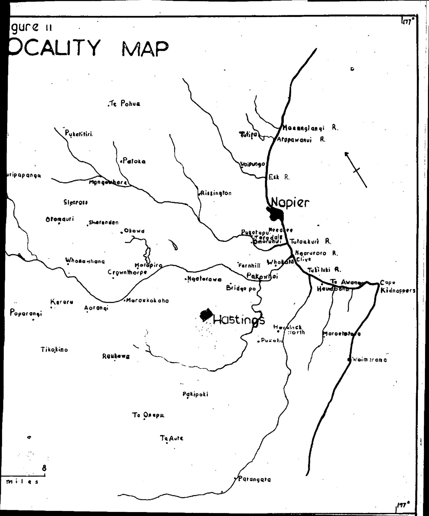
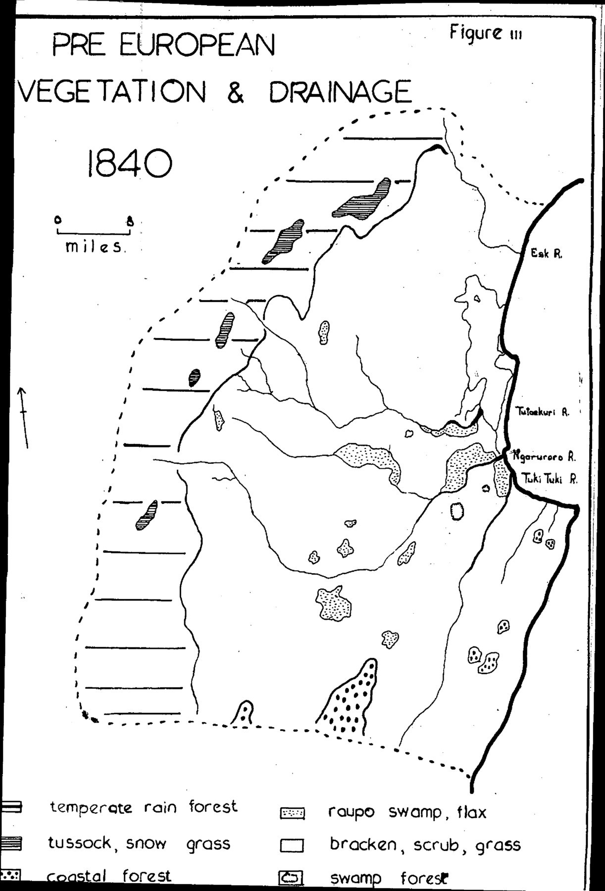
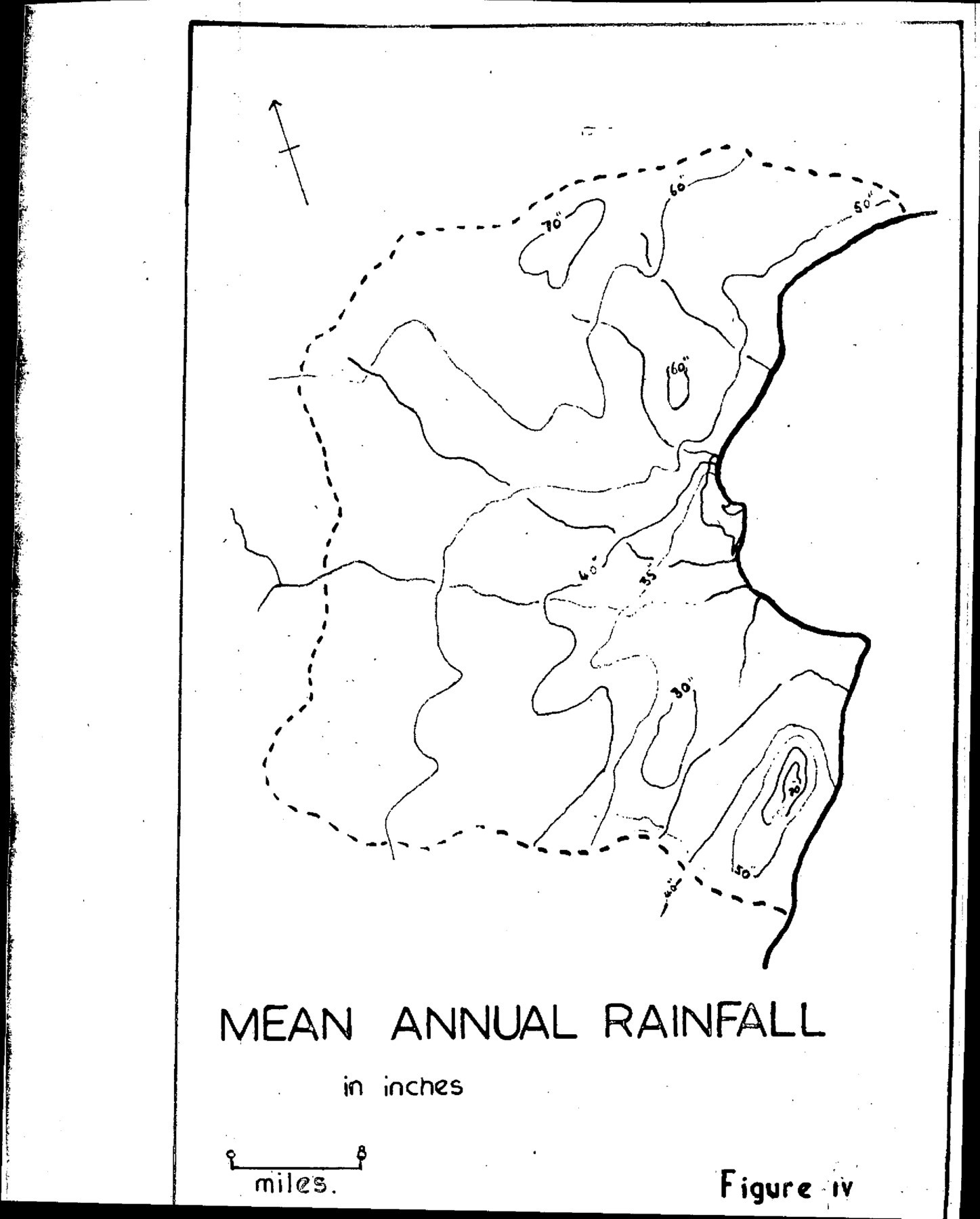
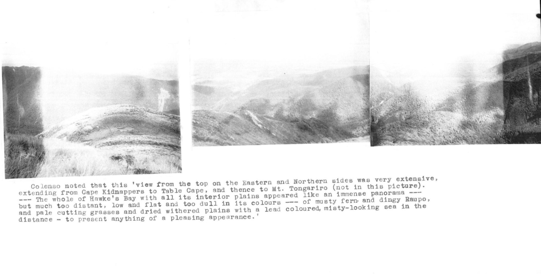
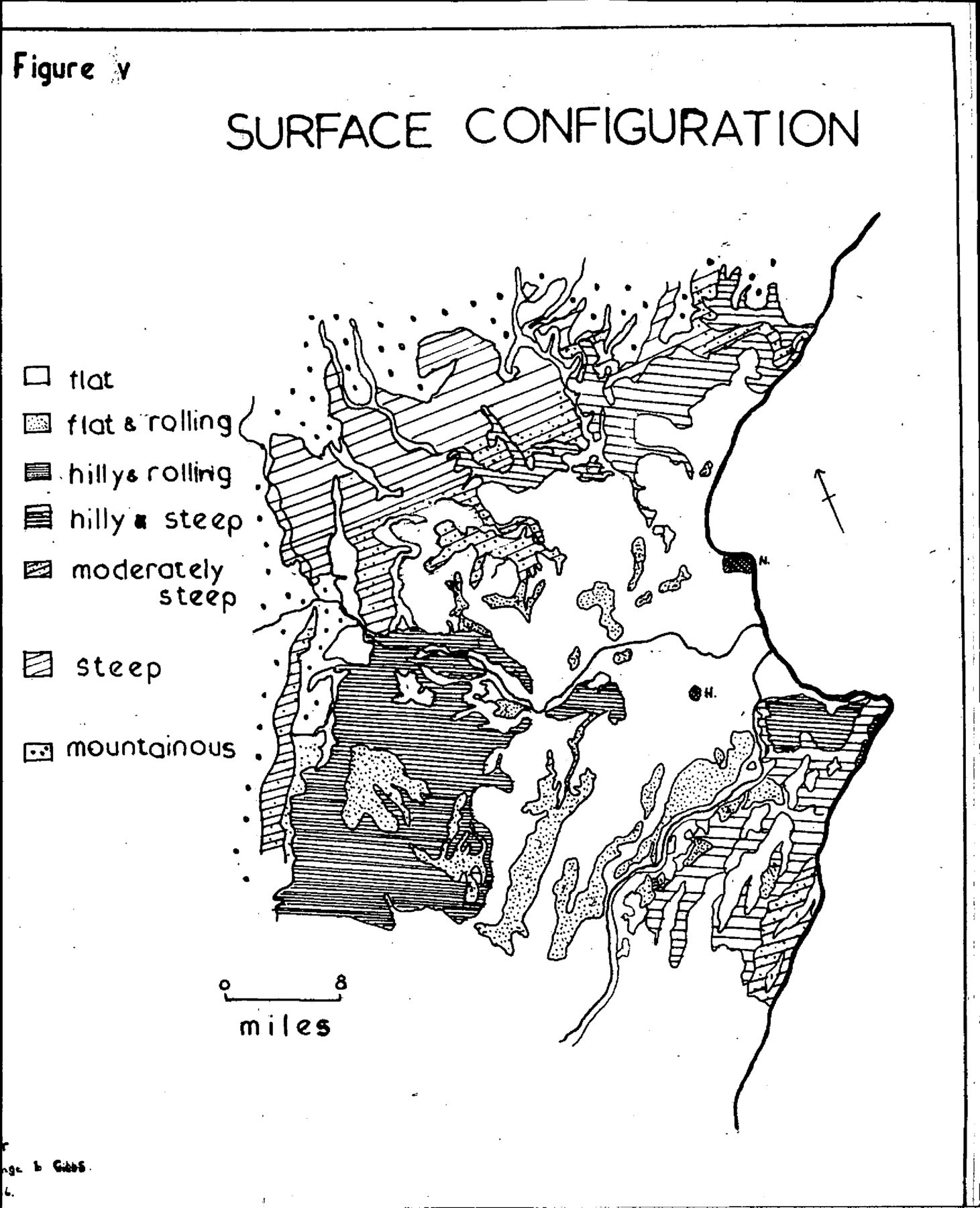
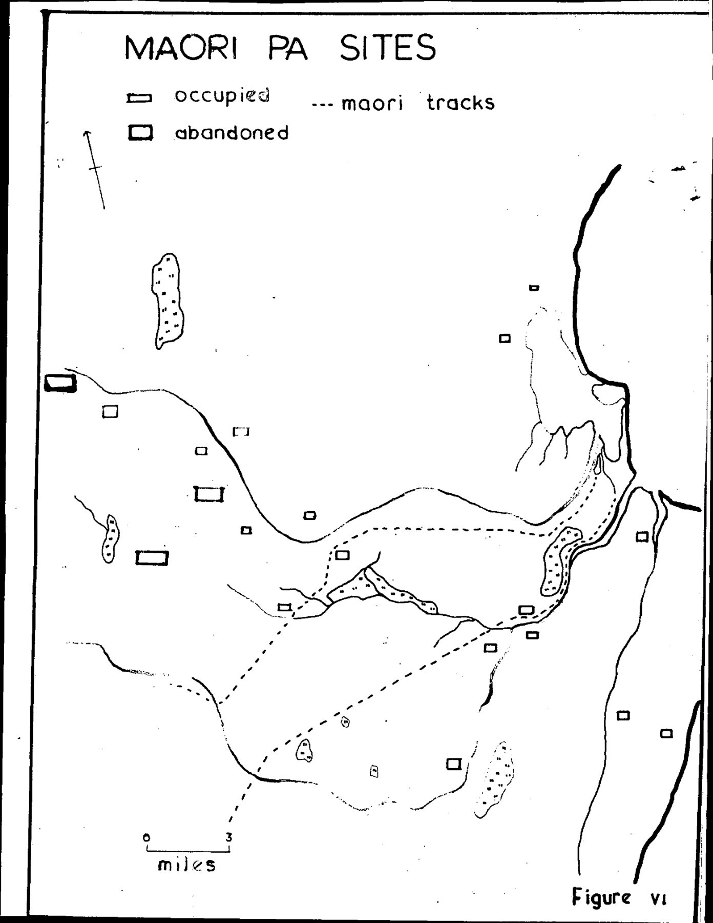
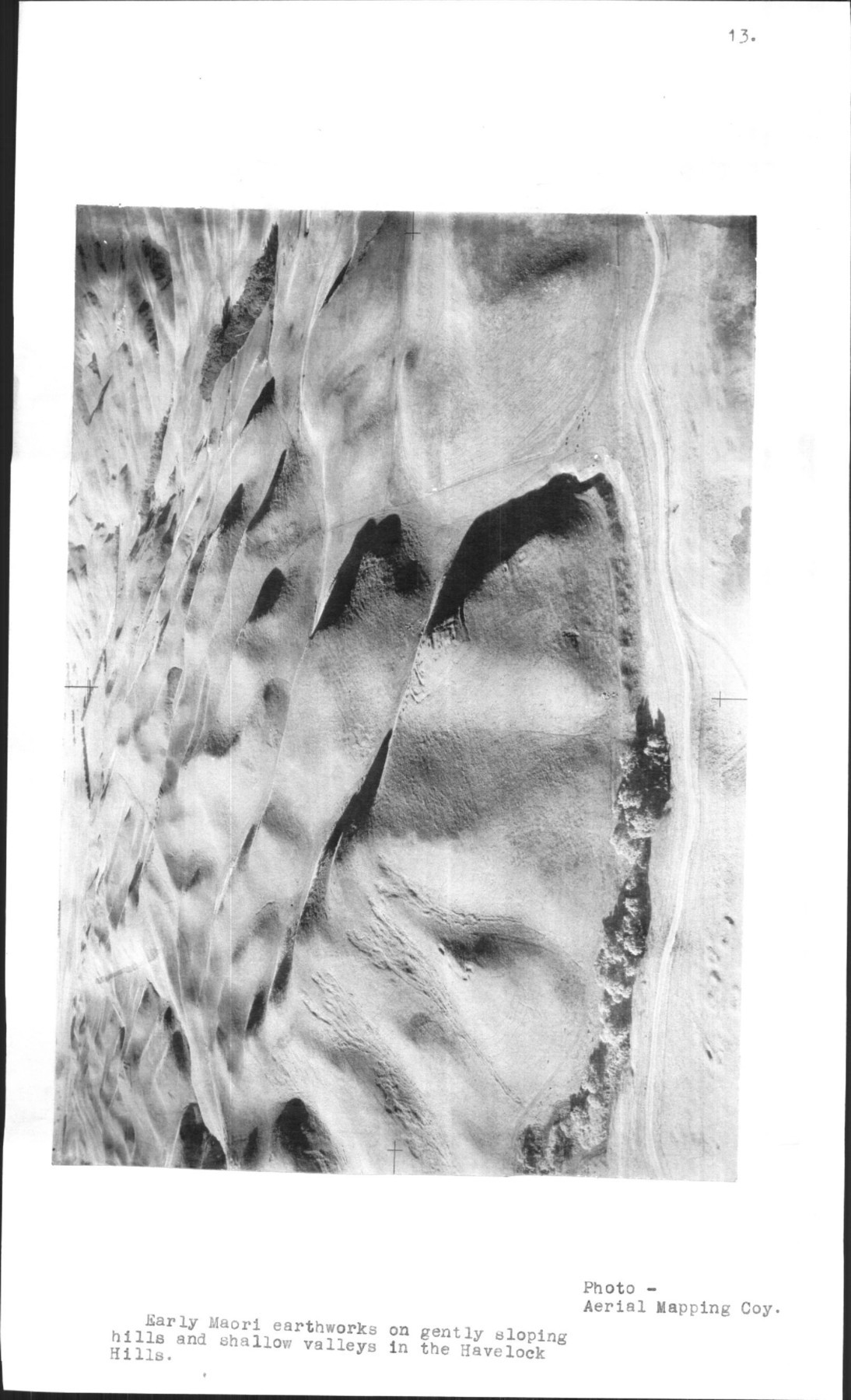
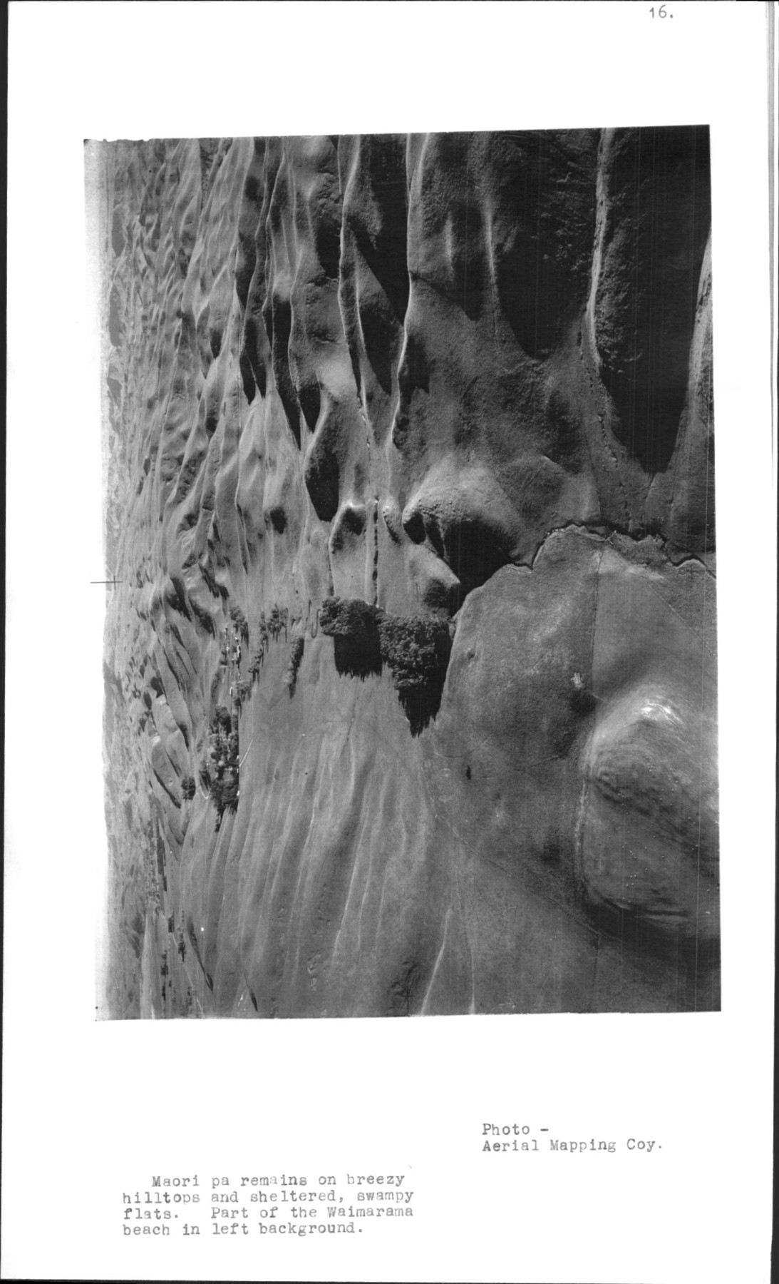
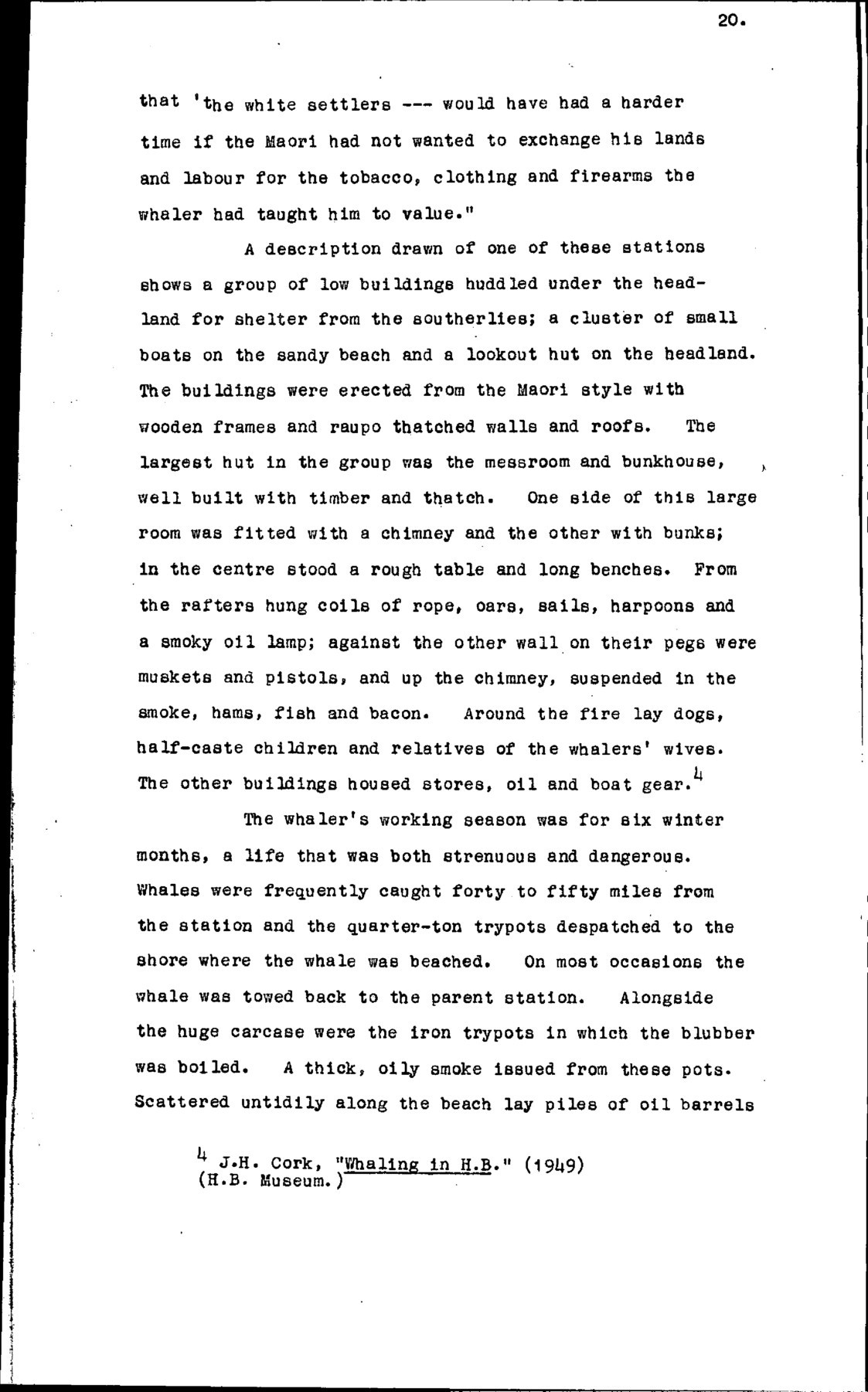
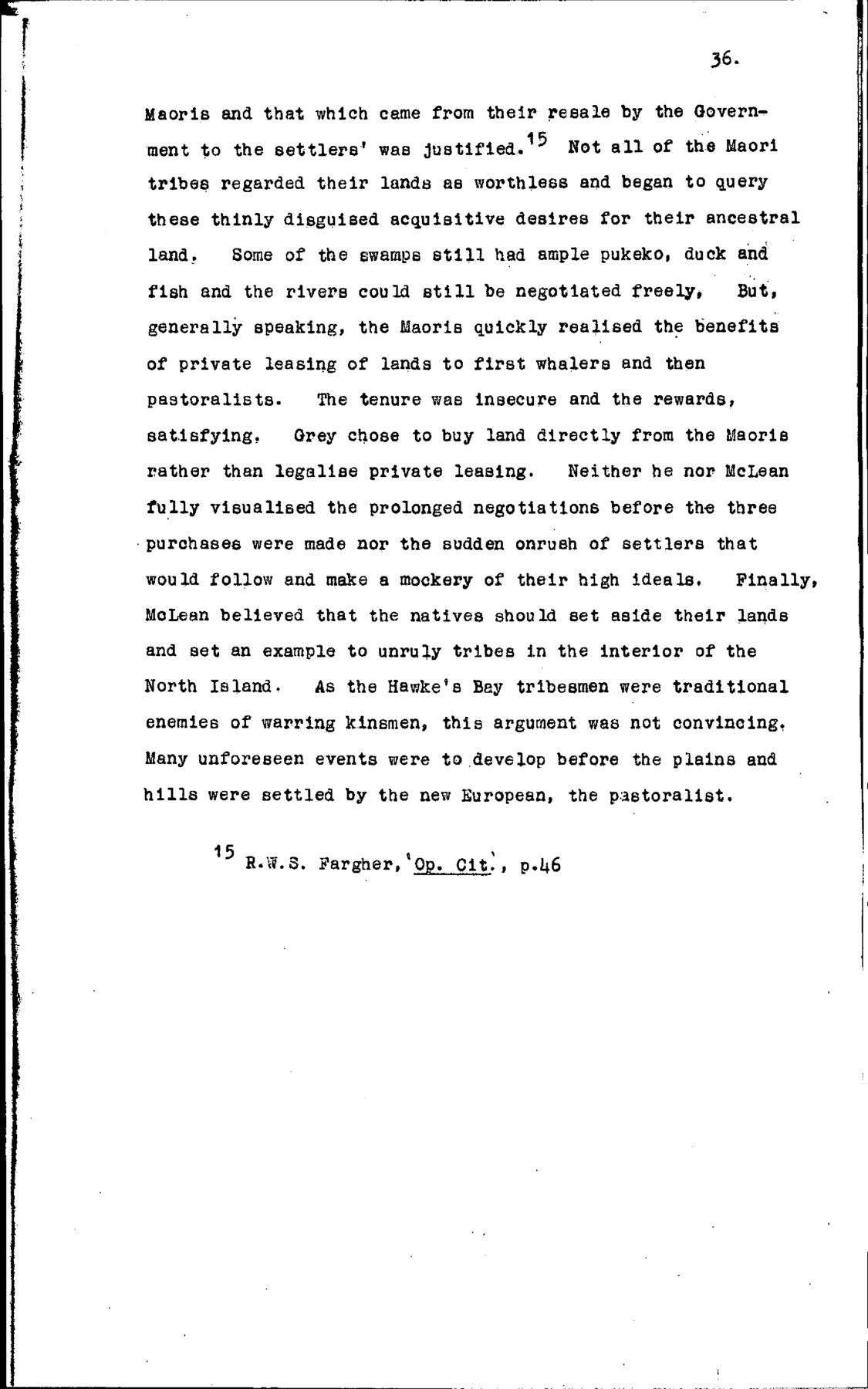
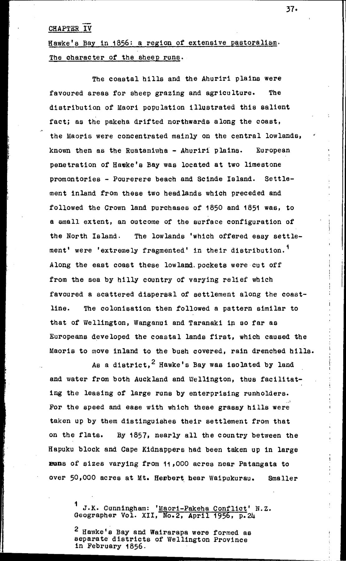
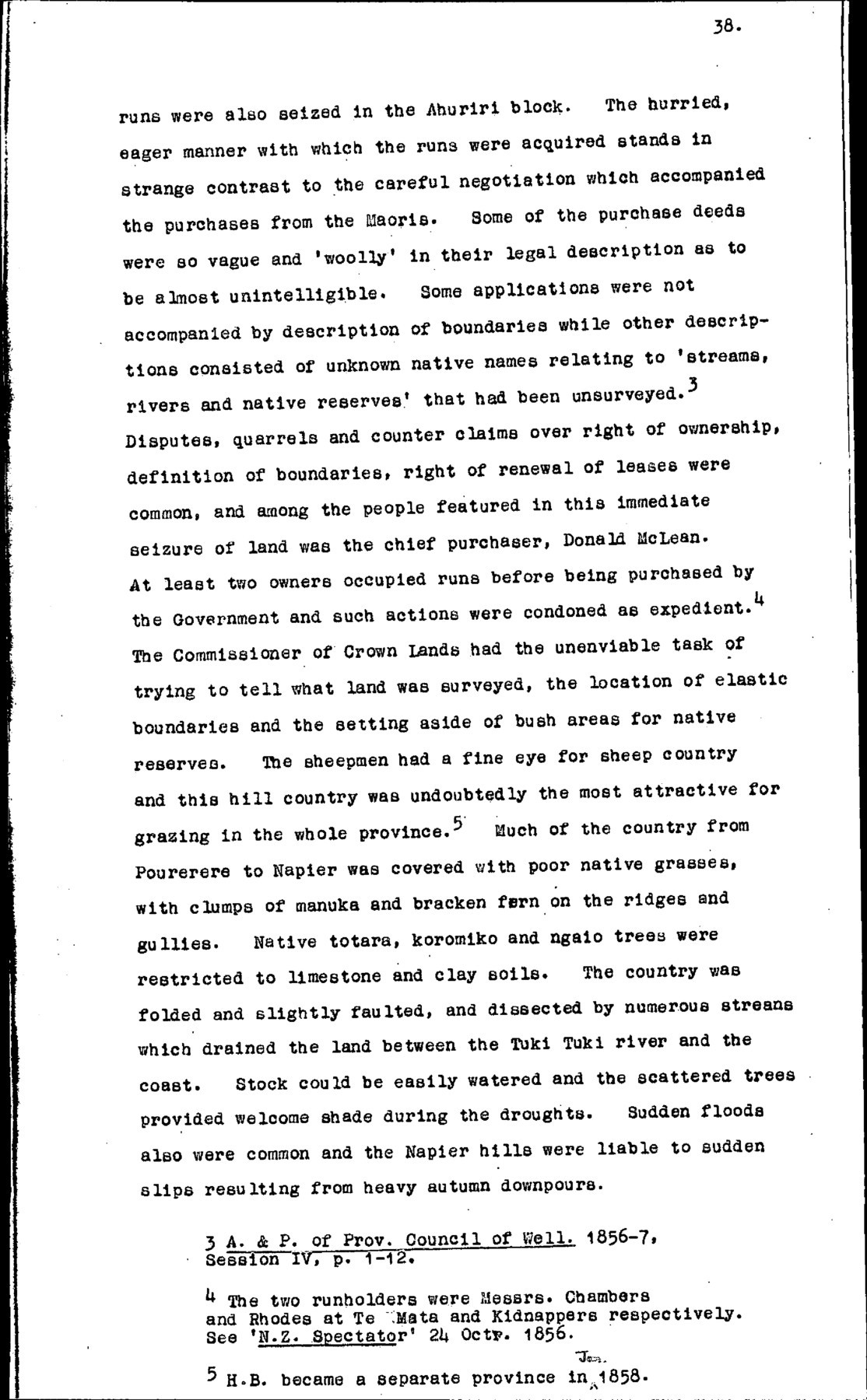
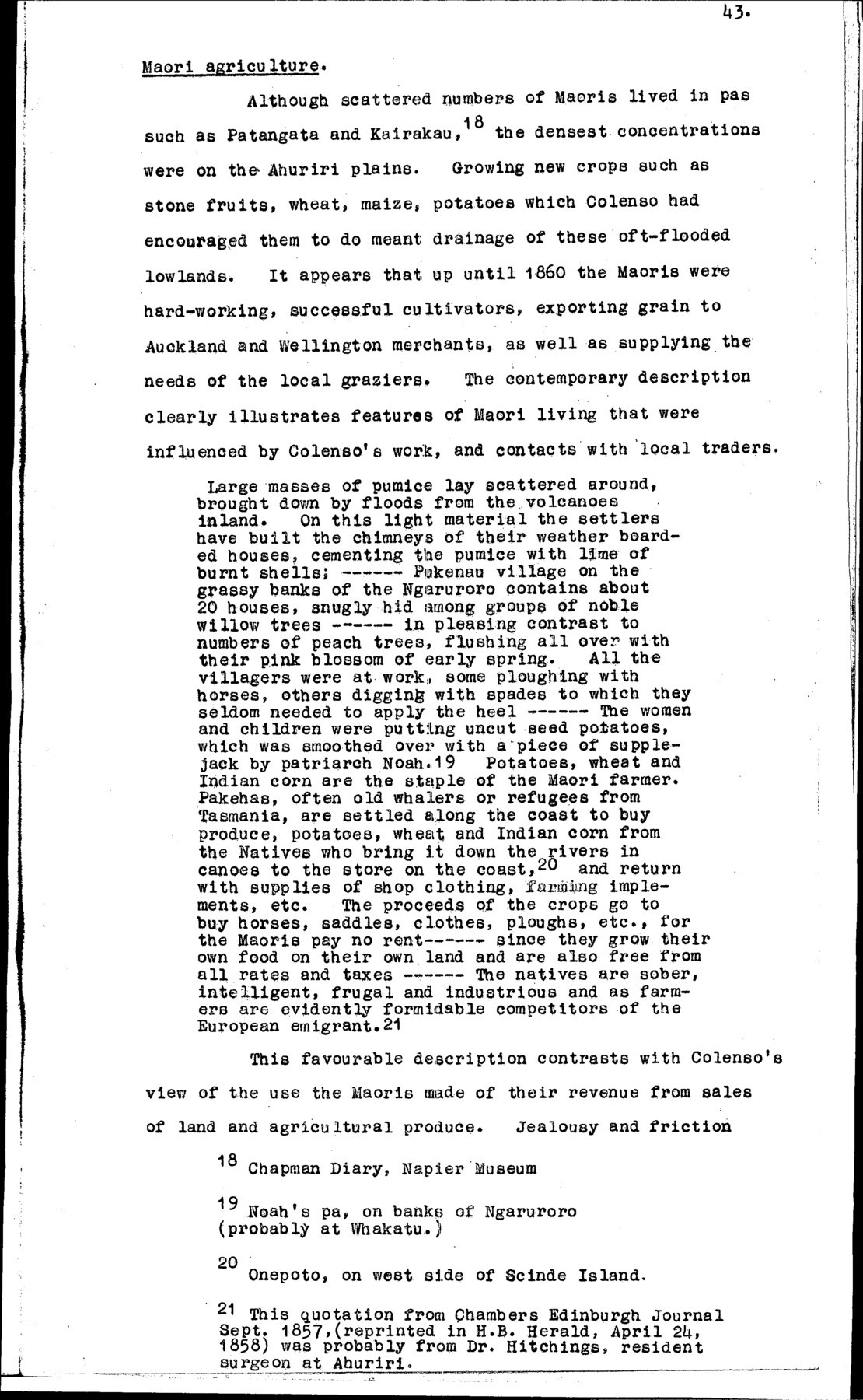
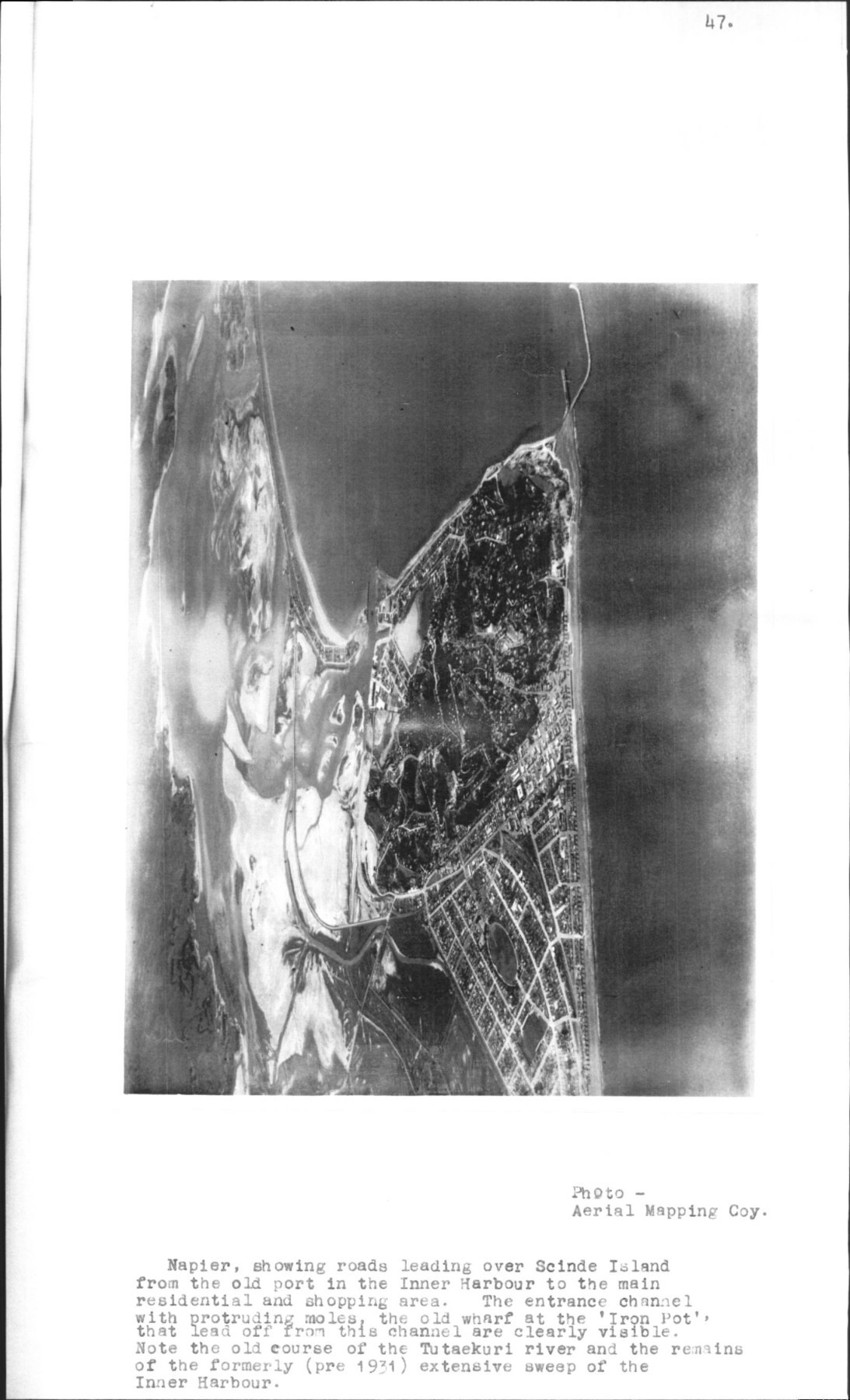
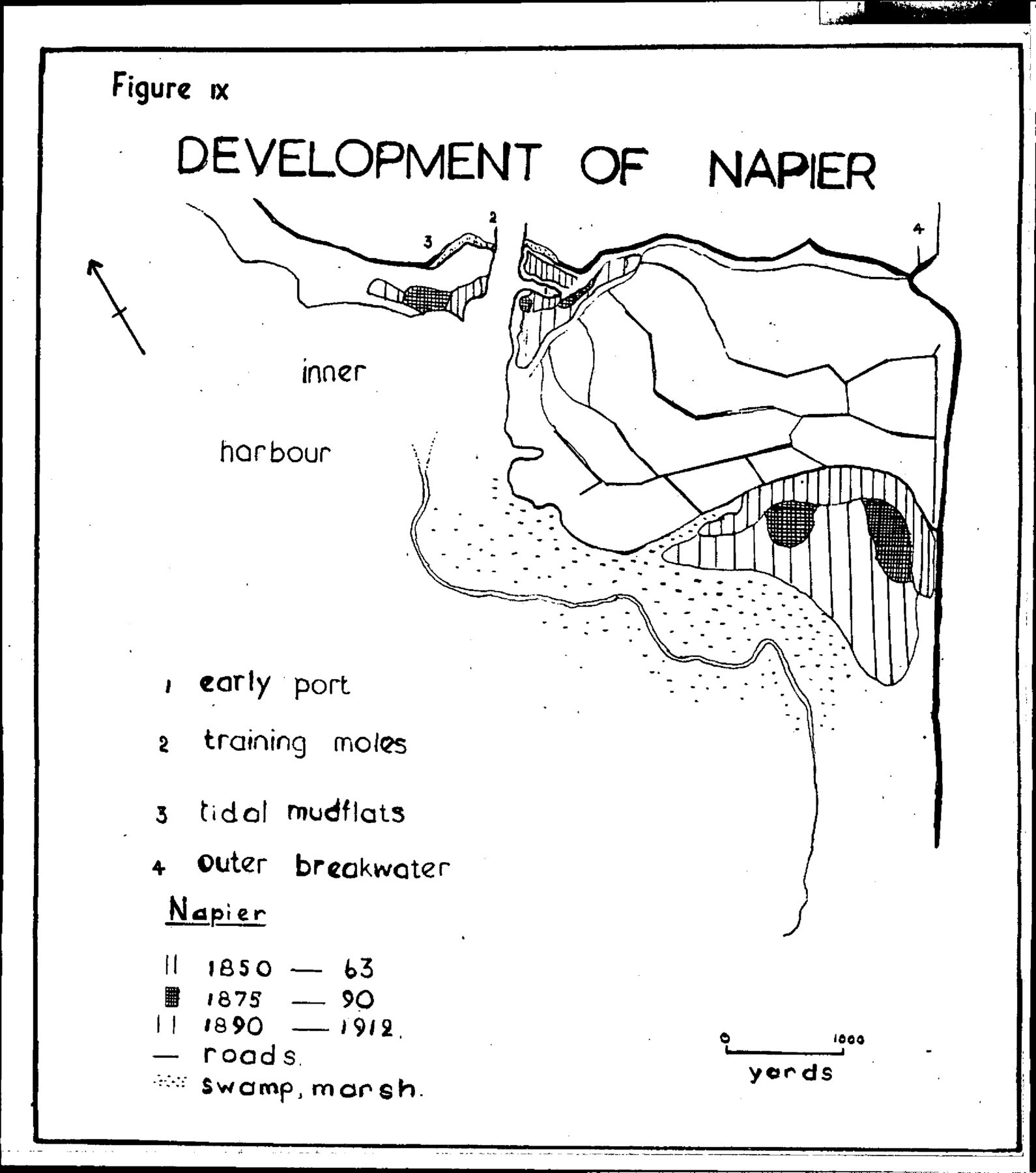
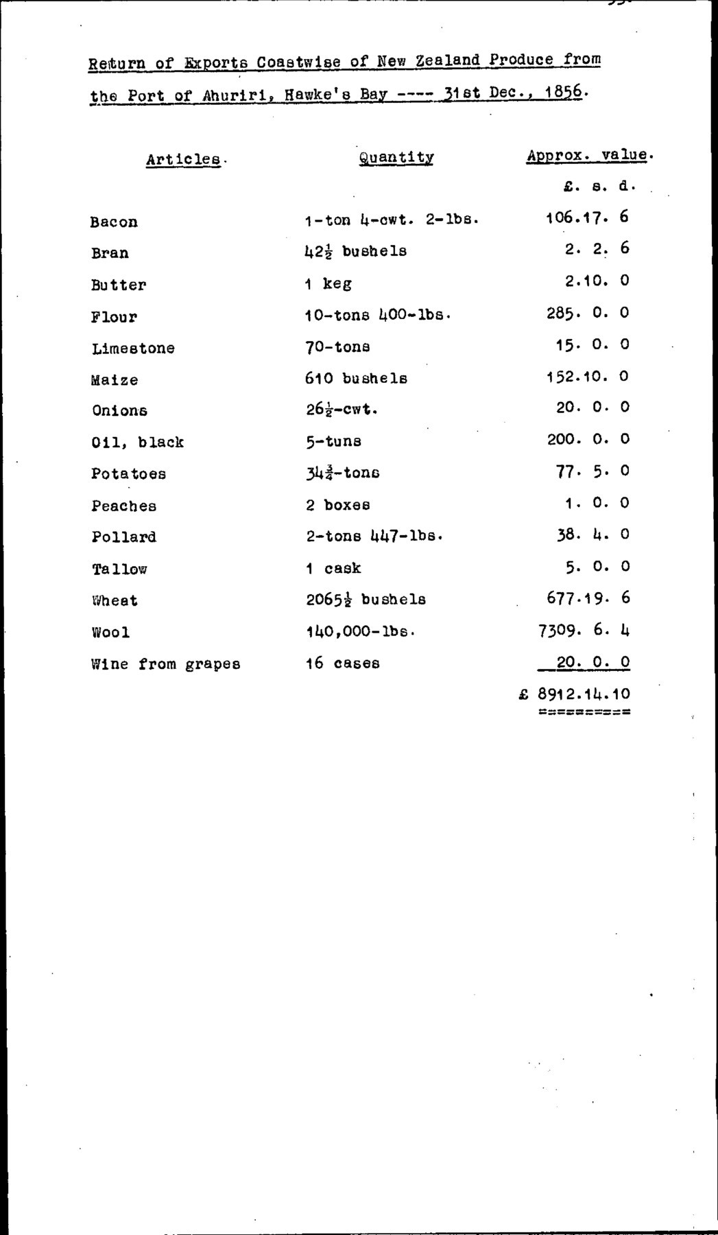
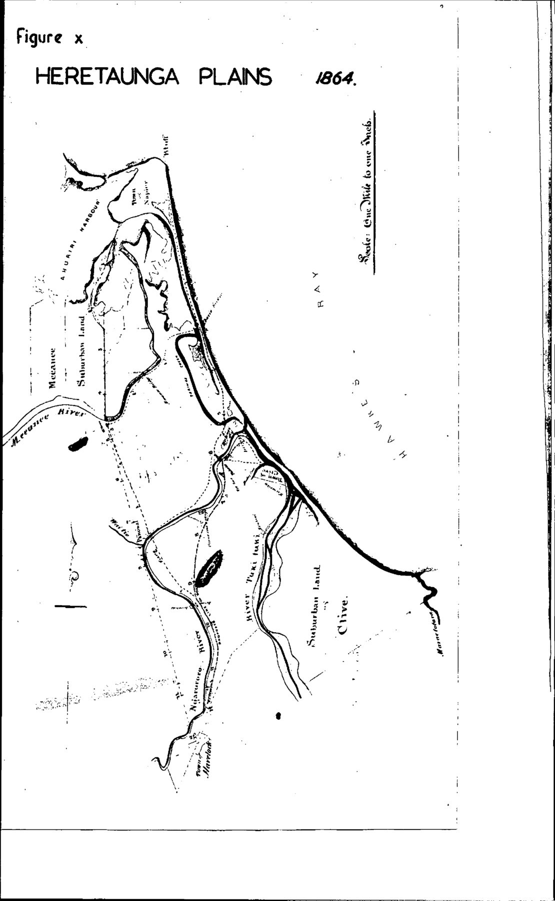
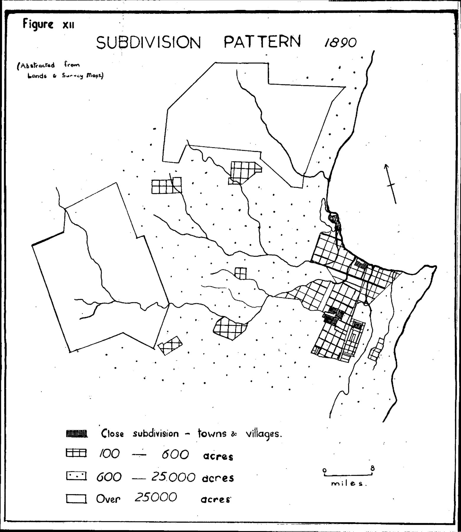
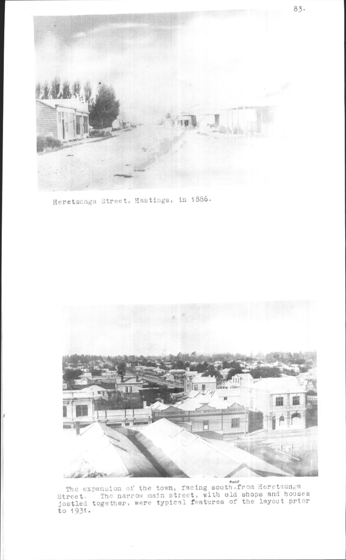
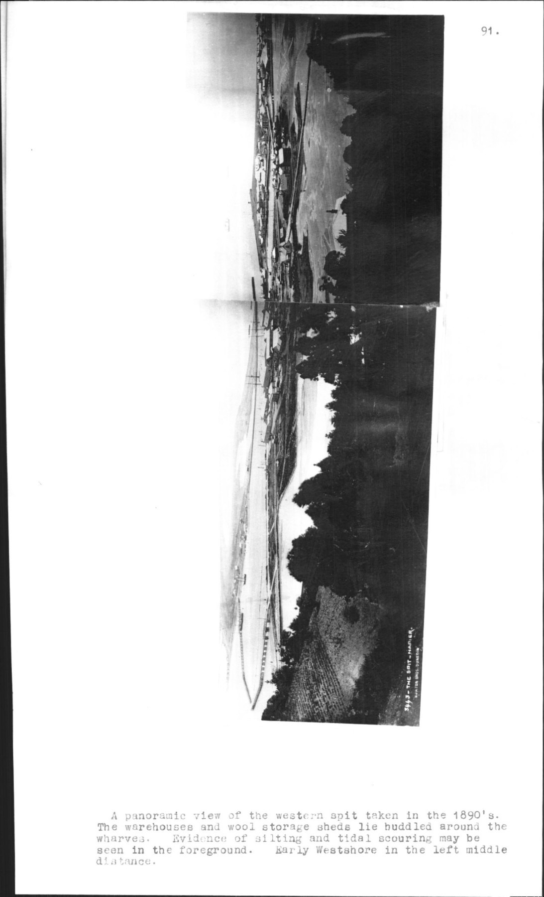
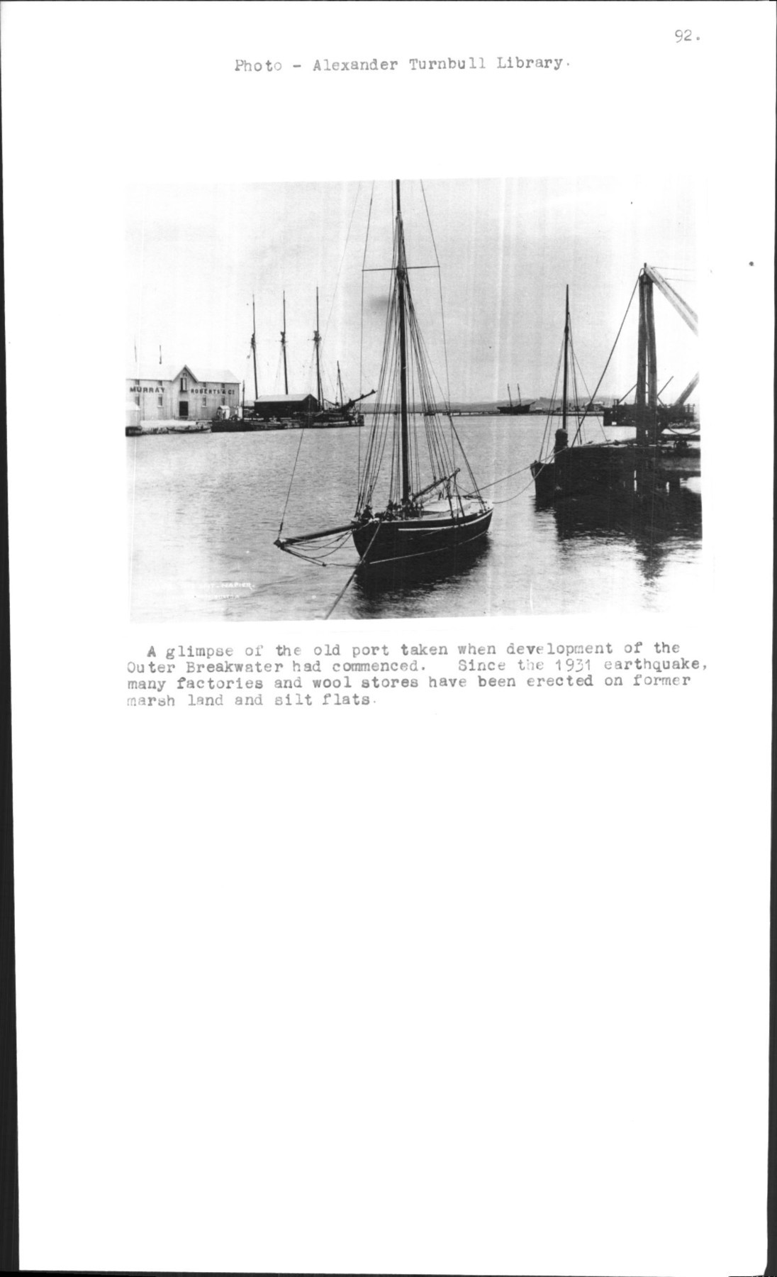
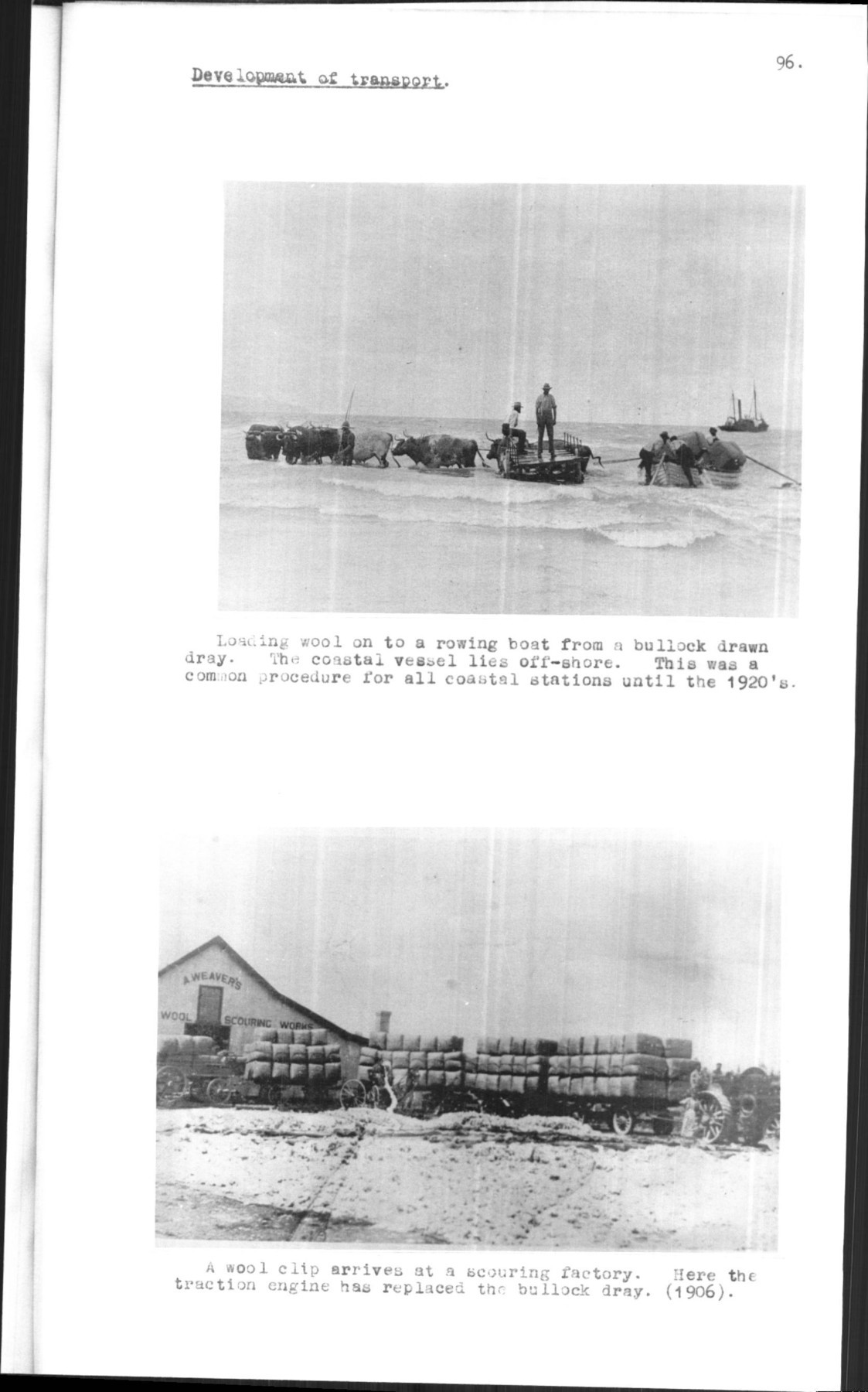
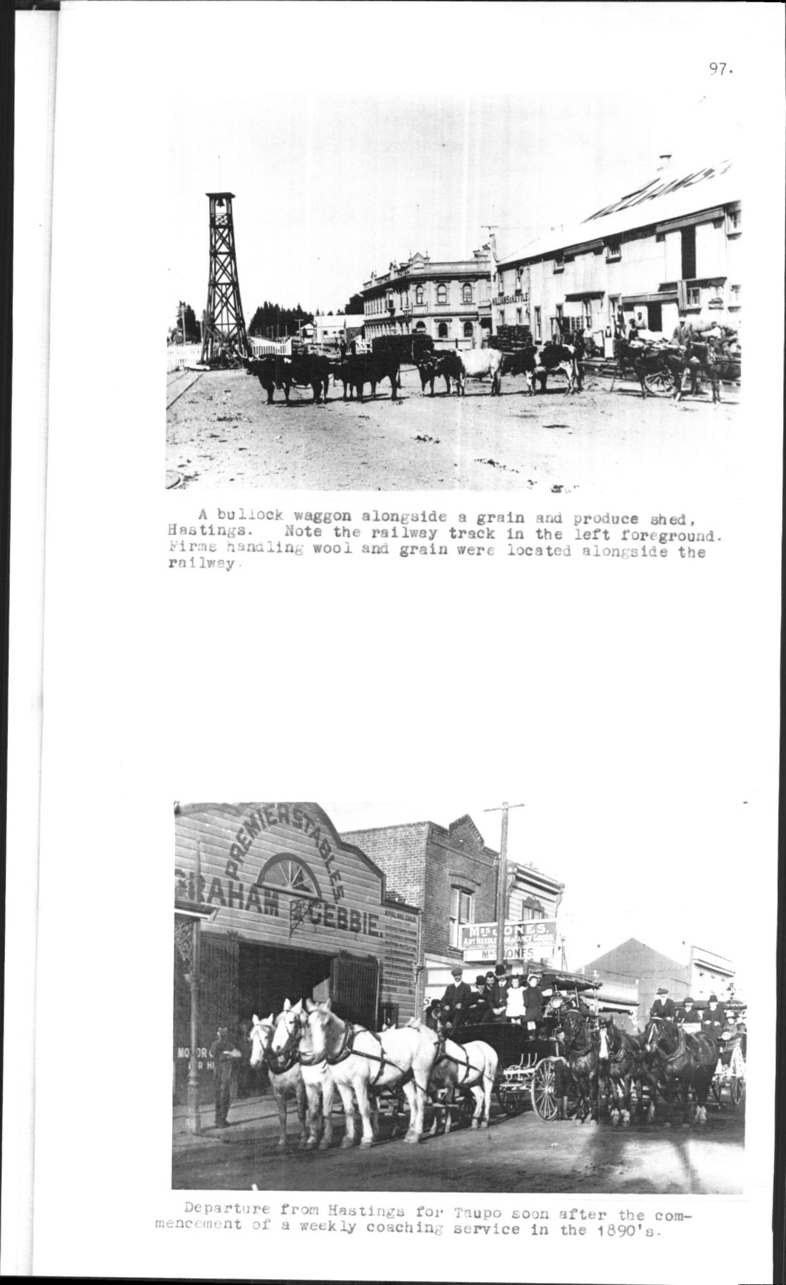
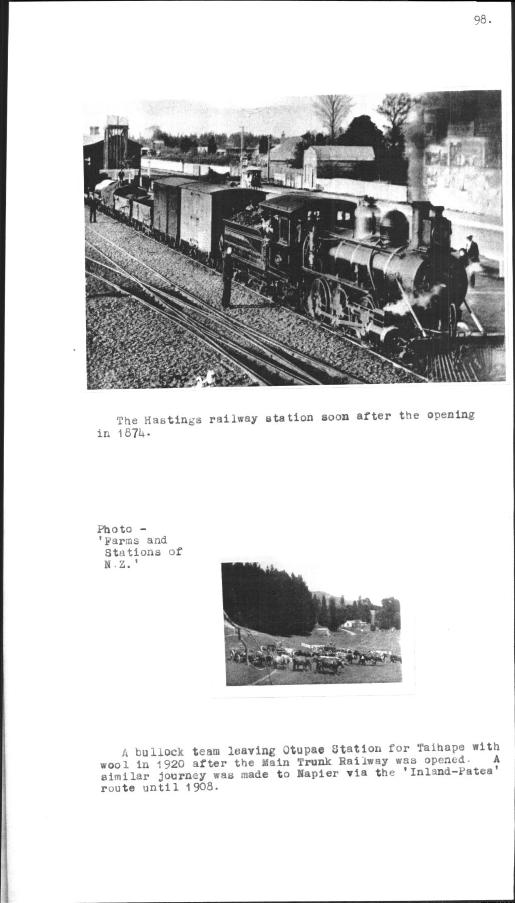
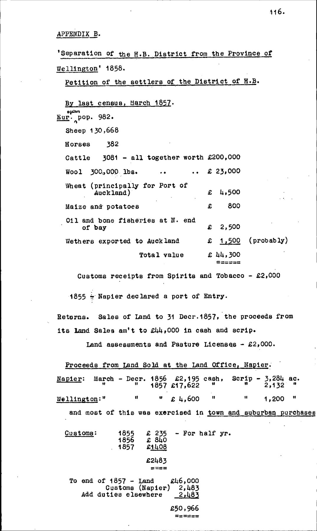
Page 130
SECONDARY.
A. G . Bagnall and C. G. Petersen: ‘William Colenso’, 1948.
E. Best: ‘Land of Tara’ – Pts. I-IV. Journal of Poly. Socy. 1917-1919.;’
Maori Agriculture’, Dom. Museum. Bull. No. 9 1925.
R. Bell: ‘Roundaway – Story of a Sheep farm’, 1953
A. H. Blake: ‘Sixty Years in N.Z.’ (1909)
T. A. Bowden: ‘Manual of N.Z. Geography’ 1871
D. A. Brown: ‘Geology of N.Z.’
‘Geology of H. B.’ (1949)
R. M. Burdon: ‘High Burdon’ (1938)
A. Claydon: ‘N.Z., Its Resources and Industries’, London, 1885.
W. Colenso: ‘In Memorium’.
D. Cresswell: ‘Early N. Z. Families’, 2nd Series, 1956
K. B. Cumberland: ‘Soil Erosion in N. Z. A Geographic reconnaisance’. [reconnaissance] (1944)
‘A Land despoiled: N. Z. About 1838’ (N. Z. Geog. April 1950, p.15)
‘A Century’s Change: Natural to Cultural Vegetation’ (G. R. Oct. 1941, pp. 529-535)
‘Jimmy Grants and Miharares: N.Z. about 1853’ (E.G. Jan. 1954, pp. 1-12
J. K. Cunningham: ‘Maori Pakeha Conflict’ – 1858-1885 N.Z. Geog. Vol XII, No. 1, 1956, pp.12-32
J. H. Davis: ‘Personal memories of H. B.’ 1857-65
F. Dieffenbach: ‘Adventure in N. Z.’ Vol. 1, p.366
W. W. Dinwiddie: ‘Old H. B.’ 1916.
G. P. Donnelly: ‘Looking Backward – N. Z. 50 years ago ’ Farms and Stations of N. Z.’ Vol 1, 1956.
A. Fountain: Letters 1866-1905
F .W. Furkert: ‘Early N.Z. Engineers’ 1949.
‘The Official Handbook of Hastings’ 1929
H. Guthrie-Smith: ‘Tutira – A story of a H. B. Sheep Station’ 1st Edition 1921.
Handbook of N. Z. 1848 1875 1885
R. P. Hill: ‘A H. B. Coastal sheep station’. Studies in farm Management. Jour. of Agric. July 1946
‘Farming in N.Z. – Hawke’s Bay. Jour. of Agric. Jan 1950
J. T . Holloway: ‘Ecological Investigations in the Nothofagus Forests in N.Z.’ N.Z. Journ. Of Forestry, Vol. V, No. 5, 1948. pp. 401 – 411.

Page 131
M. Hursthouse: ‘N.Z. – Britain of the South’ 1861.
E. A. Madden: ‘Grasslands of the North Island’, D. S. I .R. Bull. No. 79, 1940
J. N. D. McDonald: ‘N.Z. Land Legislation’ (Hist. Studies Aust. & N.Z., Novr [November]. 1952, pp. 195-211)
J. S. Polack: ‘A Narrative of travels and adventures, during a residence in that country 1831-37’. London, Vol I, 1838
Rhodes Paper, Napier.
P. W. Smallfield: ‘Farming in N. Z: Subsistence Farming’ N.Z. Jour. of Agric. Decr. 1946, p.543
R. Stout: ‘Notes on the Progress of N.Z. 1864-1884 Wellington, 1886.
K. Sinclair: ‘Maori Nationalism and the European 185-1860’ (Hist. Studies, Aust. and N.Z. Vol. 5, No. 18 1952, p.132
‘Land Utilisation Report of the Heretaunga Plains’: D. S. I. R. Bull. No. 70, 1939.
‘Soils and some related agricultural aspects of mid H. B .’ D. S. I. R . Bull. 94, 1947
Theses:
P. J. Coleman: ‘Native Land Acts and Hawke’s Bay’ (1949)
E. A. Coxon: ‘H. B. under Provincial Government 1853-76’ (1940)
T. K. Fallwell: ‘Freezing Industry of Hastings’ (1956)
W. W. Guthrie: ‘H. B. Region’ (1948)
A. H. Malcolm: ‘Some aspects of early H. B. History’ (1935)
I. V. Sage: ‘Wairarapa 1854-1954’ (1954).
D. Tebay: ‘The Separation Movement in H. B.’ (1956)
Transactions of N.Z. Institute. Vol. 30. 1897, p.515
(later the Royal Society of N.Z.) Vol. 37, 1905, p.431
Vol. 63, 1932, p.72
Vol. 82, 1951, pp.218-59
J. G. Wilson: ‘History of H.B.’ (1939).
Founding of H.B. (1951)
N. Zotov: ‘Some Correlations between vegetation and climate in N.Z.’ (N.Z. Jour. Sci. & Tech. Jan. 1938, pp.474-478).

Original digital file
YuleL838_Historical_Geography_ACYule_1958.pdf
Non-commercial use

This work is licensed under a Attribution-NonCommercial 3.0 New Zealand (CC BY-NC 3.0 NZ).
Commercial Use
Please contact us for information about using this material commercially.Can you help?
The Hawke's Bay Knowledge Bank relies on donations to make this material available. Please consider making a donation towards preserving our local history.
Visit our donations page for more information.
Description
[List of names in this title still to be added – HBKB]
Subjects
Format of the original
ThesisDate published
1958Accession number
838/1800/40836Supporters and sponsors
We sincerely thank the following businesses and organisations for their support.


Do you know something about this record?
Please note we cannot verify the accuracy of any information posted by the community.