Report of the Hawke’s Bay Earthquake 1931
N.Z. DEPARTMENT OF SCIENTIFIC AND INDUSTRIAL RESEARCH.
BULLETIN No. 43.
REPORT
OF THE
HAWKE’S BAY EARTHQUAKE
(3rd FEBRUARY, 1931).
Issued under the authority of the Right Hon. G. W. FORBES, Minister of Scientific and Industrial Research.
WELLINGTON, N.Z.
BY AUTHORITY: G. H. LONEY, GOVERNMENT PRINTER.
1933.
Price, 2s.)
N.Z. DEPARTMENT OF SCIENTIFIC AND INDUSTRIAL RESEARCH.
Extract from the N.Z. Journal of Science and Technology, Vol. XV, No. 1, pp. 1-116.
BULLETIN No. 43.
THE HAWKE’S BAY EARTHQUAKE OF 3rd FEBRUARY, 1931.
The Hon. E. A. RANSOM,
Acting Minister for Scientific and Industrial Research,
Wellington.
I have the honour to submit herewith special Bulletin on the Hawke’s Bay earthquake of 3rd February, 1931.
This report is intended mainly to give an account of the scientific investigations made of the earthquake phenomena, and to deal specially with its geological and seismological aspects. These matters were accorded special investigations by officers of the Geological Survey, Dominion Observatory, and Lands and Survey Department. Officers of the Public Works Department conducted a survey of the damage done to buildings and to engineering structures, and a condensed account of their findings has been included.
In order, however, to place together, within the compass of one publication, the events which occurred on this occasion, there has been included in this report a brief description of the Hawke’s Bay District and a summarized account of the events occurring during and shortly after the main shock of 3rd February. Conditions in Napier, being representative of the most acute characteristics of the earthquake, have, in consequence, been given most prominence in this account. Limitations of space have precluded detailed descriptions of the nature and effects of the shock in every district of Hawke’s Bay, and it is well to stress that this portion of the report is intended to serve merely as a summary of the tragic events of February, 1931, and makes no pretence of giving attention to that wealth of incident which is naturally of much interest to those concerned with particular localities.
The following account of the Hawke’s Bay earthquake represents the joint efforts of a number of investigators whose names are indicated in the respective sections which they themselves have written.
The chief lesson of the earthquake is forcibly illustrated by contrasting figures 2 and 4 on pages 9 and 10, which indicate that though the earthquake was of such severity as to wreck completely many buildings, there were others which withstood the shocks almost without any damage. It is therefore obviously possible to construct at no great additional cost buildings which will withstand very severe earthquakes, provided due consideration is given to design and care exercised in workmanship.
Had the buildings of Napier and Hastings been constructed on lines similar to that illustrated in fig. 2, the loss of life resulting from the earthquake would have been reduced to a very small figure, and the damage to property would have been comparatively slight.
E. MARSDEN, Secretary.
1 – Bulletin.
CONTENTS.
PAGE
GENERAL DESCRIPTION. F. R. Callaghan 3
1. Introduction 3
2. Occurrence of the Earthquake 6
3. Description of the Earthquake. – Napier – Fires – Port Ahuriri – The Earthquake at Sea – Hastings – Country Districts – Wairoa – Gisborne 7
4. Rescue measures 21
5. Outside assistance 22
6. Effect of Earthquake on Communications and Public Services. – Roads – Railways – Shipping – Telegraphs – Electric Light and Power 23
7. Emergency Organization. – Napier – Hospitals – Hastings 25
8. Restoration. – Railways – Post and Telegraphs – Electric Power – Gas 30
9. General 32
10. Permanent Rehabilitation 34
11. Death Roll due to the Earthquake 37
GEOLOGICAL ASPECTS OF THE HAWKE’S BAY EARTHQUAKES. J. Henderson 38
1. Introduction 38
2. The New Zealand – Tonga Ridge 39
3. Outline of the Geology of the East Coast of the North Island 40
4. Geological Structure of the East Coast of the North Island – Raukumara Section – Huiarau-Kaweka Section – Ruahine-Tararua Section – Comparison 41
5. Surface Effects of the Earthquakes 48
6. Surface Indications of Deep-seated Fractures. – Poukawa, Awanui, Bridge Pa Shears – Tension Cracks 51
7. Changes in the Level of the Ground. – Heretaunga Plain – Upraised Area – Napier – Waikokopu Railway Relevelling 61
8. Changes in the Position of Points 67
9. Conclusion 69
SPONGE BAY UPLIFT, GISBORNE, AND THE HANGAROA MUD BLOWOUT. S. W. S. Strong 76
1. The Sponge Bay Uplift 76
2. The Hangaroa Mud Blowout 78
EFFECTS OF EARTHQUAKE ON COAST-LINE NEAR NAPIER. P. Marshall 79
1. General Features of the Coast-line 79
2. Examination of Shore 80
3. Earthquake Effects on Ridges and Cliffs 90
4. Soundings 92
SEISMOLOGICAL REPORT OF THE HAWKE’S BAY EARTHQUAKE. C. E. Adams, M. A. F. Barnett and R. C. Hayes 93
Part I. – General Introduction.
1. Relation of N.Z. Seismology to that of the Pacific 93
2. General Seismology of New Zealand 95
3. Past Seismic Activity in Hawke’s Bay Region 95
4. Foreshocks 97
Part II. – The Earthquake.
1. Distribution of Seismic Intensity 97
2. The Seismograph records 99
3. The Horizontal Motion of the Ground 101
4. The Determination of the Epicentre, Time at Origin, and Focal Depth 102
5. The Aftershocks 102
DAMAGE TO BUILDINGS. A Brodie and A. G. Harris 108
1. Introduction 108
2. Buildings of Wood 108
3. Buildings with Brick Bearing-walls 109
4. Buildings with Reinforced-concrete Frames 113
5. Buildings with Structural-steel Frames 114
6. General 114
7. Building Regulations Committee 115
MAP OF NEW ZEALAND 116
THE HAWKE’S BAY EARTHQUAKE.
GENERAL DESCRIPTION.
By F. R. CALLAGHAN, Department of Scientific and Industrial Research.
INTRODUCTION.
THOUGH New Zealand has a reputation as a country of earthquakes, until recently it could readily be pointed out that these had not been of such a nature as to cause serious loss of life or property. Earthquakes more or less severe in the past, such as those of Wellington in 1848 and 1855, and of Cheviot in 1901, had occurred at a time when, or in a locality where, the chances of serious damage were small. Even the Buller earthquake of 1929 affected a district which was for the most part sparsely populated. The loss of some seventeen lives on this occasion, however, shook the belief, long held, that New Zealand, though a country of frequent tremors, was not one of disastrous earthquakes. The position was made decidedly worse, when, shortly before 11 o’clock on the morning of the 3rd February, 1931, almost the whole Dominion felt a shock, the centre of which was in the vicinity of Napier and Hastings, and whose destructive effects ranged from Gisborne in the north to Waipukurau in the south, a distance of some 140 miles. The whole of the province of Hawke’s Bay was severely shaken, and, unfortunately, the earthquake occurred with the greatest severity in the vicinity of Napier and Hastings, where the population was most dense, and the number of buildings and public structures greatest. The loss of life (approximately 260 killed) and property* was on a scale without parallel in New Zealand, and constitutes the greatest disaster which has affected the Dominion since its foundation.
Hawke’s Bay Province lies along the middle portion of the east coast of the North Island, and is geographically associated on the north with Poverty Bay, which extends from Mahia Peninsula to East Cape. The northern portion of the Hawke’s Bay Province is deeply indented by the wide semi-circular sweep of Hawke Bay, a comparatively shallow portion of the Pacific Ocean, with a depth not exceeding 50 fathoms. The offshore slope is fairly steep along the whole of the coast-line, depths of over 100 fathoms being reached at approximately ten to fifteen miles from the shore except in Hawke Bay.
The province for the most part consists of gently undulating to ridgy slopes, lying between the backbone mountain chain of the North Island and the sea, a distance of some thirty to forty miles. In the south the Ruahine Range extends north-eastwards to a point almost due west of Napier, where it merges into the general broader highland region, which comprises the Kaweka, Kaimanawa, and Ahimanawa Ranges, and their numerous offshoots. Farther north, the Huiarau Ranges continue the main line of the highland region, and north-west of Gisborne a gap occurs, separating this range from the Raukumara, which extends in a general north-easterly line towards East Cape. In the southern portion of the province the contours run generally parallel to the line of the main range and to the coast. A series of low ridges, parallel to the east coast, causes the principal drainage on this part of the province to flow south to the Manawatu from about Ormondville, and north into Hawke Bay in the vicinity of Napier.
* While it is impossible to give even an approximate figure of the loss of property sustained, some £2,500,000 was paid by the Government and by insurance companies in respect of damage done. There is no doubt that the total losses must be greatly in excess of this sum.
1*
4 THE N.Z. JOURNAL OF SCIENCE AND TECHNOLOGY. [JULY
Here the mouths of the Tukituki, Tutaekuri, and Ngaruroro converge, and within a distance of about ten miles give an outlet to drainage from southern Hawke’s Bay, the eastern slopes of the Ruahines, and the south-eastern part of the Kaweka highlands. They have formed the Heretaunga Plains, and these, together with the land adjacent to the rivers, form an area of very highly productive country. Although subject to flood, this
FIG. 1. – Locality map of the North Island showing areas affected by the Hawke’s Bay earthquake.

1933.] CALLAGHAN. – HAWKE’S BAY EARTHQUAKE. 5
area constitutes one of the most fertile portions of New Zealand, and is closely settled; mixed farming, pastoral farming, and fruit-growing figure prominently in the rural industries of this district. The downs to the east, and the hilly offshoots of the Ruahines, are admirably adapted for sheep, the density of the flocks being high.
While the area to the south and west of Napier possesses a generally easy contour rising gradually to the main range, that farther to the north-west, and running from Tangoio almost to Wairoa, is comprised of sharp ridges, ending in cliffs on the coast of Hawke Bay up to 1,200 ft. in height. These ridges continue westward, and merge in the central highland area. The main drainage of this district is carried by the Mohaka River, but a series of lesser streams enter Hawke Bay at a number of points. North of Mohaka the valley and basin of the Wairoa give another patch of easier contoured land, which is farmed more intensively than that immediately to the south. Between Wairoa and Gisborne the land is much broken into ridges, and the fertile flats at Poverty Bay in the vicinity of Gisborne give place, on the north, to the offshoots of the Raukumara Ranges, between which lie a succession of steep-sided valleys, extending almost to East Cape.
The drainage of the eastern slopes of the Ruahine Ranges is effected by the Tukituki River and its numerous tributaries, which junction in the neighbourhood of Waipawa and Waipukurau. From Waipawa this river, deflected by the coastal watershed, which extends southwards from Cape Kidnappers, flows north-east, entering the sea near Clive.
Napier (fig. 6) is situated on a peninsula, the northern extremity of which is called Scinde Island, a limestone hill, whose northern and eastern sides are precipitous. Though at one time an island in the strict sense of the term, Scinde Island is now connected with the mainland by a tongue of land built up by the combined action of the Tutaekuri River and the sea. Approach from the flat land is comparatively easy. The whole of Scinde Island is occupied by the larger residences of Napier and by public institutions and reserves. The winding Tutaekuri River borders the town on the west, and flows in a channel generally to the west of what a former course did, the old channel being reclaimed, and the land now built upon. The main business portion of Napier was located on the flat land immediately to the south of Scinde Island, particularly on the seaward side of this area. Farther south extended a large residential area, gradually narrowing to an isthmus near the site of the Napier Boys’ High School. Southwards from Scinde Island, on the seaward side, runs the Marine Parade, facing a magnificent sweep of ocean beach extending as far as the mouth of the Ngaruroro River. The Tutaekuri River flows into the Inner Harbour, a shallow expanse of water representing the last portion of the enclosed unreclaimed sea, behind Scinde Island. On the seaward side of the Inner Harbour a long spit extends southwards from Petane to the western extremity of Scinde Island, broken at its junction therewith by a channel, through which the waters of the Tutaekuri and the lesser streams entering the Inner Harbour reach the sea. The suburb of West Shore is located at the southern end of this shingle-spit. On the seaward side of this channel is Port Ahuriri, located on the triangular-shaped area of reclaimed land north-west of Scinde Island. The Port of Napier is an open roadstead, which provides for the overseas shipping of Hawke’s Bay. On the extreme north-east point of Scinde Island a breakwater has been constructed to accommodate vessels of deep draught. Through the channel
A small-scale map of New Zealand appears on p. 116.

6 THE N.Z. JOURNAL OF SCIENCE AND TECHNOLOGY. [JULY
vessels of shallow draught (up to 15 ft.) could proceed to the more sheltered Inner Harbour. Considerable portions of the Inner Harbour to the south and west of Port Ahuriri have been reclaimed and stores built thereon. From the south-west corner of Scinde Island a causeway and bridge (the West Shore Bridge) connects Napier with northern parts of Hawke’s Bay, thus avoiding a long detour round the Inner Harbour.
Hastings lies on a plain twelve miles south of Napier, and is level throughout, the streets being laid out on the rectangular system. Throughout the alluvial plain, water can be secured from artesian wells sunk through the surface soil into the shingly substrata, and both Napier and Hastings depended for their water-supply on these wells.
The chief towns in the affected area and their respective populations at the time of the earthquake were : –
Napier 16,025
Taradale 1,170
Hastings 10,850
Havelock North 1,060
Waipawa 1,180
Waipukurau 1,895
Wairoa 2,435
Gisborne 13,635
The populations of the counties immediately affected, were as follows : –
Cook 20,460
Wairoa 8,015
Hawke’s Bay 44,125
Waipawa 4,640
Waipukurau 2,885
Patangata 2,730
OCCURRENCE OF THE EARTHQUAKE.
Without any warning at 10.47 a.m. (10.17 a.m. N.Z.M.T.) New Zealand summer-time, on the morning of the 3rd February, 1931, the main shock occurred, being most severely felt in the area surrounding Napier and Hastings. It has been asserted that, in one or two instances where building operations requiring precise levelling were in progress, the fact that structures in which care had been taken to ensure correct levels were found to be out of alignment gave some evidence that tilting had preceded the actual earthquake. It is difficult, however, to substantiate completely these claims.
The evidence of the actual nature of the first shock has been gleaned from those who experienced and noted its nature. There was not, throughout the whole of the Hawke’s Bay District, any station equipped to give an instrumental record of the earthquake. The consensus of opinion is that there were two shocks of very different characteristics, occurring within a brief interval of some thirty seconds of one another. The first shock developed rapidly in intensity, had a distinctly uplifting motion associated with violent and confused swaying. Then followed a pause of about half a minute, till the second shock occurred, with a motion resembling a sharp bump downwards. Records of the total duration of these two shakes vary considerably, but that taken by the wireless operator aboard the m.v. “Taranaki” in the roadstead, who was actually facing a clock, seems the best authenticated available. This officer stated that the tremors continued for two and a half minutes from the time of the first noticeable shock. The earthquake was felt throughout New Zealand, with the exception of the northern portion of the Auckland Peninsula and Otago. At Napier it was followed by a period of quiet, but before long further tremors commenced and continued almost without interruption for some days. At its height, the shock was of such severity that it was difficult to remain

1933.] CALLAGHAN – HAWKE’S BAY EARTHQUAKE. 7
standing erect, but owing probably to some peculiarity in the inherent nature of the movement there are few instances reported where people were thrown to the ground, despite the violence of the tremors.
DESCRIPTION OF THE EARTHQUAKE.
Napier.
On Sunday, 1st February, an unusually heavy swell was breaking along the foreshore at Napier and scattering spray across the Marine Parade, although there was an entire absence of wind during the day. By Monday this swell had ceased, and Tuesday morning throughout Hawke’s Bay dawned bright, warm, and sunny, with light variable breezes. For some months previously less than the average amount of rain had fallen, and the whole of the Hawke’s Bay District was experiencing the mild drought conditions of midsummer. A soaking rain would have been generally welcome. In these circumstances, the weather on the morning of Tuesday, 3rd February, appeared sultry, still, and slightly oppressive.
In Napier and Hastings the normal quiet conditions of a week-day morning found numbers of country and suburban people engaged in business in shops and offices. Many were passing along the veranda – covered footpaths, examining the window displays on their way to other business premises. Just outside the kerbing many cars were parked, while their owners were engaged in business in the nearby premises. The main business and shopping area of Napier is located in the north-east corner of the level land, facing the sea-coast on the east, and is abutted by the approaches to the Bluff Hill section of Scinde Island on the north. The Marine Parade, fringed with a line of stately Norfolk Pines, runs along the sea-front. From it at the Band Rotunda Herschel Street branches off at a sharp angle towards the hill. Hastings Street, running parallel, leads into Shakespeare Road, which continues over the hill to Port Ahuriri. Farther to the west Dalton Street runs in a similar northerly direction. At right angles to these streets are four business streets, Browning, Tennyson, Emerson, and Dickens Streets. Within this group of streets lay the main business portion of Napier. The streets were bordered by buildings, for the most part two stories high, though some were extended to three. As in the case of most growing New Zealand towns, the buildings in the business area showed in their structure the rapid evolution which had proceeded since the town was founded some sixty or seventy years previously. Those erected in recent years were of permanent materials, brick, stone, concrete, or ferro-concrete, while those erected earlier were, for the most part, of wooden structure. In some of these latter, attempts had been made to bring their general appearance more up to date by the erection of fronts in concrete or brick, the wooden portion of the building at the rear being left intact.
Suddenly, without any apparent warning, the earth began to sway, the oscillations increasing rapidly in severity. Eyewitnesses saw buildings sway to an alarming extent, telegraph-poles leaned over at critical angles, cracks and fissures appeared both in the walls of buildings and on the surface of the streets. Insecure parapets and chimneys collapsed. Veranda-posts became bent, while it became difficult to stand erect owing to the intensity of the swaying motion of the earth. Control of motor-cars was a matter of great difficulty owing to the peculiar nature of the earth-movement.

8 THE N.Z. JOURNAL OF SCIENCE AND TECHNOLOGY. [JULY
Inside buildings everything was thrown into the utmost confusion; goods fell from shelves, furnishings either collapsed or slid into unusual positions; plaster fell from ceilings; pillars and girders collapsed, bringing the upper floors down on to those beneath.
Every one inside, dazed with terror at the suddenness of the catastrophe, made for the streets over the piles of debris which blocked their way. Unfortunately some were already trapped, blocked, pinioned, or stunned, and unable to make this dash for safety. Many had just reached the footpath or the street when the second downward bump came, and this shock brought down in great confusion, and with a sickening roar, buildings already fractured by the violent swaying they had just experienced. This entombed, crushed, or maimed many just as they were about to reach the comparative safety of the street. Verandas collapsed under the weight of falling debris, which splayed out into the streets, crushing motor-cars and other vehicles standing by the kerb. Huge masses of masonry from the façades and parapets hurtled into the middle of the business streets mentioned above, which became almost impassable. From the falling masonry a strange deep roar arose, the crashing timbers, the splintering of glass amidst an atmosphere choked with thick clouds of dust, produced an effect which defies description. When to such scenes are added the cries of agony of those pinned beneath the wreckage or rushing wounded, bleeding, and covered with dust, the whole scene becomes a hideous nightmare. Such were the first sights witnessed in Napier immediately after the great first earthquake shock on the morning of the 3rd February.
There followed immediately a death-like hush, interrupted only by the cries of the afflicted and intensified by the occasional creak of straining iron and timber or the trickle of crumbling masonry.
So appalling and sudden was the actual incidence of the earthquake that it left the people dazed and stunned. The scenes that met their eyes were beyond belief. It was incomprehensible that what was a splendid town but half an hour previously should be thus suddenly converted to a heap of debris over which lay a thick pall of dust. All had been through a few moments of terrific nervous strain. Those who escaped regarded their escape as miraculous, and they shuddered when they thought of those who were not so fortunate and who now lay beneath the heaps of debris. Once the first dazed feeling was over, thoughts turned to relations and friends. Those in the town sought their families in the residential area. Those at home rushed to town to know the fate of their relations and friends in the destroyed business area. The work of rescue began promptly, and the injured were eagerly sought for and extricated wherever possible from the mass of fallen debris. No semblance of a panic occurred, and once the first dazed feelings passed, all endeavours were devoted to the work of rescue. It is extremely difficult for any one who has not experienced a severe earthquake to realize the sickening nervous shock it produces, and therefore it is still more difficult to appreciate at its true value the high quality of the rescue work done by a populace affected with the degree of nervous tension which those few minutes of the actual earthquake had inflicted upon them.
By 11 o’clock an aerial view of Napier would have shown debris blocking Browning, Tennyson, Emerson, and Hastings Streets, while the Marine Parade and Dickens Street were also considerably littered. In this area buildings in all stages of collapse were seen. Some were but a heap of bricks and mortar. Others were twisted, fissured, and canted into

1933.] CALLAGHAN. – HAWKE’S BAY EARTHQUAKE. 9
fantastic shapes. There were some few still completely intact except for a few cracks. The second shock apparently had the effect of throwing many of the outer walls of two-storied buildings outwards, leaving the interior walls to hold up the remainder of the building, and exposing to the street-view the interiors of the upper rooms. In many cases the roofs, once the supporting walls gave way, crashed and ” pancaked ” over the street or on top of the heap of debris. The quality of the building more or less decided its fate in the earthquake. Where the construction was on sound lines even the 1terrific strains to which buildings were subjected did not cause their collapse. There was a number of buildings soundly constructed of ferro-concrete which showed no ill effects of the earthquake beyond slight cracks. Others, where the construction was faulty, were reduced to ruins.
The whole town bore the appearance of having been subjected to a severe artillery attack for some days, and many of the buildings, of which portions still remained erect, constituted a continued source of danger owing to their cracked and fissured walls. While the shocks continued these buildings were in imminent danger of collapse.
Outside the business area of Napier considerable damage occurred in some of the larger public buildings. The Hospital, situated on the western slopes of Scinde Island, was, unfortunately, the scene of one of the major tragedies of the earthquake, in that the three-storied Nurses’ Home collapsed completely, entombing the night staff which was then asleep. Many of the wards at the Hospital were also so fractured by the movement that they had to be abandoned. The Park Island Home for the Aged, situated on the foothills to the west of Napier, collapsed in part and entombed a
FIG. 2. – Dalgety’s Building, Napier. An example of a well-constructed building which withstood the effects of the earthquake without damage. This view was taken some days after the shock.

1933.] CALLAGHAN. – HAWKE’S BAY EARTHQUAKE. 11
number of the inmates. At the Technical College, an old two-storied brick building, the pupils had just assembled after the morning interval. The building collapsed, and was responsible for a heavy death roll among the scholars and staff, though, fortunately, the brief interval between the two main shocks permitted numbers of the pupils to reach positions of safety. It must be regarded as a fortunate circumstance in connection with the other school buildings that at the time of the occurrence of the earthquake most of the pupils were out of doors at the morning recess, otherwise the death roll of scholars might have been much heavier.
In private houses, which were mostly of wooden construction, the damage was confined to the chimneys, the water-supply, and drainage services. In most private houses in Napier the chimneys were of brick, and these collapsed either completely or else broke off where the brickwork emerged from the roof. The movement of the ground was such as to fracture most of the underground pipe systems, and consequently both the water-supply and the sewerage system were put out of commission. Instances occurred where houses were moved from their foundations by the violence of the shock. Among the larger houses situated on the hill the damage was relatively greater than those in Napier South. This damage was especially marked in two-story houses where the upper story was constructed of different material from the lower. In many of these cases the top story collapsed, the roof ” pancaking ” and lying at an astonishing angle either on the lower story or flat on the ground. Residences on the Bluff portion of Scinde Island were, in a number of cases, tilted and brought perilously near the new cliffs formed by the splaying down of the outer limestone face of the Bluff.
Many houses on the hill canted badly, and, generally speaking, fractures of timbers, window-panes, and roofs were exceedingly common. It was fortunate that in the private houses, on account of the warm weather and the hour of the day, there were probably very few fires alight either in grates or in ranges. Had there been fires in use for cooking the midday meal, or had the earthquake occurred in colder weather, then there is no doubt that the violence of the shake would have either thrown lighted material into the rooms, or flames would have found their way through the cracked brickwork to the wooden fabric of the houses, thereby causing widespread conflagration among private homes.
Nevertheless, the damage done to private houses was such as to render them practically uninhabitable for the time being, and people who had been through the experiences of the shake were disinclined to return to their dwellings, preferring to remain out of doors, camped in their gardens, in open spaces, or on the sea-front along the Marine Parade. Consequently, as the day wore on towards evening, and the shocks continued, people dragged articles of furniture from the buildings into the open, and there tended to the injured and wounded, and generally transferred their mode of living from indoors to the open.
Following the main shock, the sea was noticed to recede along the whole length of the Marine Parade, leaving a considerable additional width of beach above water. This movement was the occasion for much alarm, it being feared that it might possibly be a prelude to a tidal wave. * Consequently, many resorted to the slopes of Scinde Island Hill, but, fortunately, the tidal wave did not materialize, and it was found afterwards that the recession of the sea was occasioned by the fact that the land in that vicinity
* “Tidal wave ” here is not used with its strict meaning, but refers to the sea wave produced by an earthquake.

12 THE N.Z. JOURNAL OF SCIENCE AND TECHNOLOGY. [JULY
had been raised from 3 ft. to 8 ft. by the seismic disturbance. Although there was every reason for the fears at the time that an earthquake sea wave would be the result of such shock, yet there is no record of the Napier earthquake having produced any marked tidal wave around the shores of New Zealand.
The seaward face of Scinde Island, known as the Bluff Hill, is comprised of steep limestone cliffs, at the base of which is the Marine Parade and the Breakwater Road. The effect of the earthquake was to bring down vast quantities of the cliffs on all the steeper portions along this road, so that it was very effectively blocked by the material which splayed out towards the sea. Similar slips were apparent all round the margin of Scinde Island and along the roads traversing it, wherever these passed through cuttings.
In the cemetery, also located on the western portion of Scinde Island, much damage was done to tombstones and the parapets surrounding graves. Generally speaking, over the whole of Napier, both on the flat and on the hill, the surface of the ground suffered severely from wrenching, and numerous fissures opened as the result of this violent action. The most pronounced effects of this fissuring on the flat were evident along the original bed of the Tutaekuri River, which formerly flowed in an arc almost through the centre of that portion of Napier town situated on the flat ground.
Fires.
As is unfortunately the case in all great earthquakes, outbreaks of fire followed rapidly. Within three minutes of the first big quake the first outbreak of fire occurred in a chemist’s shop in Emerson street. This outbreak fortunately was confined to this shop, and did not spread to adjoining premises. Almost simultaneously, outbreaks occurred in two other chemist’s shops situated in Hastings Street, one of which was located in the Masonic Hotel block. The fire brigade attempted to deal with all these outbreaks, but the pressure of water rapidly diminished, so that their efforts, which at first appeared hopeful, were rendered futile.
The conditions for the spread of the flames were very favourable, because, although it was early observed that all the fires appeared to be on the east side of Hastings Street, and therefore that the westerly wind would only, at most, cause the block of buildings between that street and the sea front to be burnt out, unfortunately, within less than an hour after the earthquake, the direction of the wind changed completely round, so that the fresh easterly breeze made not only the work of the brigade much more difficult, but threatened the larger area of ruined business premises on the western side of Hastings Street. Water was first drawn from the baths on the Marine Parade, but as these were situated too far from the fires for the hose available, an attempt was made to obtain a supply by pumping from the sea farther down the Parade. The suction hose, however, became blocked with shingle, and the attempt had to be abandoned. The only supply then remaining available to the brigade was one from a well, situated in the vicinity of Clive Square, into which sea-water percolated through the substrata of shingle. Even while the ordinary town mains supplied from reservoirs which were located at Thompson and Cameron Roads and in Dalton Street furnished a certain amount of water in the earlier fire-fighting, after the first few minutes the pressure available was so small that all the water had to to be passed through the fire pumps.
With the wind continuing as a fresh breeze from the east, the fire continued to spread in a westerly direction during the whole of the afternoon, and reached all the collapsed business premises and public buildings between

14 THE N.Z. JOURNAL OF SCIENCE AND TECHNOLOGY. [JULY
Tennyson Street and the lower slopes of the hill. The four blocks between Emerson and Tennyson Streets were completely gutted as far as Clive Square, with the exception of a few buildings which were saved by the use of water from the well referred to above.
At dusk on Tuesday the direction of the wind changed to the south, and it appeared as though the progress of the fire to the south was checked. Later on, however, during the night, the wind changed again to the north,
FIG. 6. CITY OF NAPIER AND ENVIRONS
Showing Damage by Earthquake and Fire (Feb. 1931)
Hawke Bay
PORT AHURIRI
Light Signal Stn
Light
WESTSHORE
H.M.S. Veronica
Inner Harbour (Ahuriri Lagoon)
EAST COAST RAILWAY
Collapsed Span
Tutaekuri River
Taradale Napier Road
Old River
Floor of Lagoon uplifted by Earthquake
Approx. line of Mean High Water prior to 1931 E’quake
Purimu Creek Pump Stn
Scinde Island
The Iron Port
North Pond
Public Hospital
South Pond
Hospital Hill
Botanical Gardens
Breakwater
Lighthouse
Trig 60
Signal Station
Clive Square
Tiffen Park
Nelson Park
McLean Park
see inset
Business Part of City Showing Buildings Scale Double that of Main Map
Napier Central School
Cameron Road
Colenso Av
Hooker Av
May Av
Milton Road
Fire Stn.
Shakespeare Road
Govt Bldgs
Herschel St.
Court House
Browning ST.
Bank of N.Z.
Council Chbrs.
Band Rotunda
Natl Bank
Union Bank
Mothers Rest
Cenotaph
Carlyle ST
Emerson ST
P.O. Savings
Dickens St.
Thackeray St.
Dalton St.
R.C. Cathedral
Tech Coll.
Station ST
Vautier ST
Hastings ST
Marine Parade
Damaged by Earthquake Earthquake and Fire Slips
After map by H.F. Butcher Community Planning. Vol 1 No 3
At dusk on Tuesday the direction of the wind changed to the south, and it appeared as though the progress of the fire to the south was checked.
Later on, however, during the night, the wind changed again to the north,

1933.] CALLAGHAN. – HAWKE’S BAY EARTHQUAKE. 15
and the fire continued to spread southwards in the earthquake-destroyed blocks between Emerson and Dickens Streets, with the result that these two blocks were almost completely devastated also. By Wednesday morning the spread of the fires had almost ceased, and it is estimated that over 10 acres of the business portion of the town was completely gutted. Included in this area were buildings which had withstood the effects of the earthquake fairly well, only to be destroyed, later on, by fire.
When Wednesday morning dawned, the main business portion of Napier was therefore an earthquake and fire pile of wreckage. Fires still smouldered in many places over this desolation, and it was difficult to guess how many unfortunate people, entombed beneath the debris, met their death from the advancing flames. (Fig. 5.)
The accompanying map indicates the portions of Napier which were wrecked by the earthquake, and destroyed by fire, and it will be observed that the fire reached almost all buildings which had been seriously damaged by the earthquake.
Port Ahuriri.
On the north-western edge of Scinde Island the land slopes fairly steeply down to Battery Road. From Battery Road out to the channel providing the entrance to Inner Harbour extends an area of land which is partly reclaimed. At the apex of this triangle and along its western side stand the business premises and stores of Port Ahuriri, and between these and Battery Road are the residences of the Port. On the shore facing the Inner Harbour is a wharf, and nearby the railway-station. The H.M.S. “Veronica” had been berthed at Port Ahuriri wharf shortly before the earthquake, and the elevation of the sea-bottom which occurred caused this vessel to rest on the mud at low water after the earthquake.
On the wharf at Port Ahuriri the shake appeared as a terrific upthrust from beneath, vessels at the wharf appearing to rise to the level of the wharf planking. In the movement of the ground, the piles, wharf decking, and fillings became twisted, bent, and fissured to an extraordinary extent. Shortly after the main shake the water from the Inner Harbour began to pour out from the channel into Hawke Bay. Fire started in the top story of the Robjohns Hindmarsh building in the warehouse business section, which lay between the “Iron Pot,” a dock facing the channel, and the sea. In this area all the wholesale warehouses, wool-stores, and post-office caught fire, and the strong westerly wind on Wednesday morning assisted the fire to complete the destruction of these premises.
An observer at Port Ahuriri recorded fifty-five shocks from 8 p.m. on Tuesday evening to 5 a.m. on Wednesday morning.
The fire at the Port, though covering a lesser area than in Napier, continued to blaze for a longer period, and the whole of the business portion of the Port was practically destroyed. The Inner Harbour, opposite Port Ahuriri, having been emptied of its water within a few hours after the occurrence of the main shock, remained elevated, and large quantities of fish were entrapped in the shallow pools which dotted its surface. In the deeper portions, nearer the channels, lessening of the depth of the water was noted. The bridge spanning a portion of the Inner Harbour, and leading to the West Shore, suffered considerably, one of its spans collapsing, thus cutting off road communications northwards from Napier. The causeway on either side of this bridge was fissured and cracked to an astonishing extent, rendering it totally impassable for vehicular traffic.

16 THE N.Z. JOURNAL OF SCIENCE AND TECHNOLOGY. [JULY
The Earthquake at Sea.
The Napier Harbour is an open roadstead, and at the time of the earthquake the m.v. “ Taranaki” and the s.s. “ Northumberland ” were lying about three miles offshore, awaiting cargo. Aboard these vessels no warning rumbles of any kind were noticed, but the whole of the frames of the ships quivered and continued to do so as though something serious had happened to the engines. The derricks and the rigging vibrated vehemently. The quivering motion was followed by two or three sharp bumps as though the vessels had actually struck the sea-floor heavily, and the jolting action was sufficient to throw members of the forecastle crew out of their bunks. The shore gangs had just come aboard to commence work when the earthquake occurred. There was an immediate rush on deck, but uncanny as were the feelings of those aboard the vessels, the sight which met their eyes in the direction of the shore was more awe-inspiring. Those portions of Napier which were within view were seen to be collapsing amidst clouds of dust. All round the shore, as far as the eye could see, from Cape Kidnappers to the south-east, past the Bluff Hill, and along the cliffs bordering the west margin of Hawke Bay, clouds of dust were seen to arise, while those who were observing the breakwater were of the opinion that they saw it undulating, while it fissured and cracked. To some of the watchers it appeared that the whole of Napier seemed to elevate itself, then to subside, and to become obscure in a pall of dust, which, when it cleared, revealed a stricken town.
Soundings were immediately taken under the two vessels, and it was found that in both cases considerable shoaling had taken place, and in one case it was assumed that the floor of the ocean had risen some 18 ft. Immediately the vessels raised anchors and headed out of the muddy water, which appeared all round them, to deeper water farther out to sea.
The s.s. “Waipiata,” arriving in the Napier roadstead, also reported shoaling outside the harbour limits. Later on in the day the view of the stricken district from the ships at sea became even more tragic. With the spread of the fires vast volumes of smoke rose up and formed huge cauliflower-headed cumulus clouds over Napier and Port Ahuriri, while inland a similar smoke pillar could be seen in the direction of Hastings. Throughout the day the vessels, though anchored still farther from the shore, were able to feel, from time to time, the quivers of the succeeding shocks.
Hastings.
In Hastings the circumstances of the earthquake were very similar to those in Napier. The business portion of Hastings was less confined than that of Napier. Nevertheless, scarcely a building in this portion of the town escaped damage. The main business street, Heretaunga Street, immediately after the first severe shock, became fringed with buildings in all stages of destruction, in accordance with their varied capacity to withstand the severe jolting shocks which afflicted the whole area. The earthquake in Hastings was stated to have a motion which could be described as a corkscrew twist. (Fig. 7.)
The damage throughout the town was much on the same lines as that which occurred in Napier, only on a slightly lesser scale. In Heretaunga Street, Roach’s, one of the largest drapers’ shops, completely collapsed,

1933.] CALLAGHAN. – HAWKE’S BAY EARTHQUAKE. 17
and buried within its ruins many of the employees behind the counters and a number of customers. The Public Library also collapsed, and entombed many people perusing newspapers in the reading-room. It was common to see numbers of buildings, whose outer walls had completely collapsed, exposing the interiors of all rooms facing the streets. The streets themselves were littered with huge masses of debris, dislodged from parapets and walls, the tangled mass of electric light and telephone wires intermingled with a large portion of those buildings whose collapse had been complete.
Motor-cars standing by the kerb were, in many cases, crushed, and in some instances loss of life occurred to those seated in them.
The tower of the post-office crashed on to the road, while the Grand Hotel, the largest building in Hastings, collapsed almost completely. Only those comparatively few buildings which were solidly constructed of ferro-concrete withstood the shocks without serious damage. In the private residences all chimneys were down, and the sewerage and water-main systems suffered serious dislocation. Fissures opened in the streets, and were conspicuous wherever fillings or embankments had been made.
As in Napier, fire followed rapidly in the wake of the earthquake, but owing to the fact that a better water-supply was available this was kept in much better control, and the three or four threatening outbreaks which occurred were fairly well kept in check. However, a very considerable block was gutted on the corner of Heretaunga Street and Karamu Road, and also two other blocks facing each other across King Street, and bordering Heretaunga Street.
The accompanying map of Hastings indicates the business area which suffered destruction, and also the areas gutted by fire. (Fig. 8.)
FIG. 7. – Street scene in Hastings after the earthquake.
18 THE N.Z. JOURNAL OF SCIENCE AND TECHNOLOGY. [JULY
Country Districts.
Outside of Napier and Hastings considerable damage was done in all of the smaller towns throughout southern Hawke’s Bay, really serious damage occurring as far south as Waipukurau, a distance of some forty-five miles by road from Napier. At Greenmeadows, a few miles south of Napier, a Roman Catholic Seminary was partly wrecked, the chapel being destroyed, with the loss of nine lives. The rural character of the district in this vicinity made the visible damage less apparent, but examination of the actual damage, led to the conclusion that the nature of the movement here was of an exceptionally severe character. Taradale, in close proximity to Greenmeadows, was considerably wrecked, and loss of life occurred. At
FIG. 8
PART OF THE TOWN OF
HASTINGS
Showing Damage by Earthquake and Fire
Feb 1931.
Scale
CHAINS 10 5 0 10 20 30 40 CHAINS (1/2 mile)
Damaged by Earthquake Damaged by Earthquake and Fire
GEH After Map by H. F. Butcher, Community Planning, Vol 1, No 3.
LASCELLES ST.
CHARLES ST.
SOUTHLAND ST.
NELSON ST.
KING ST.
MARKET ST.
ST AUBYN ST.
AVENUE ST.
QUEEN ST.
HERETAUNGA ST.
EASTBOURNE ST.
LYNDON RD
SOUTHAMPTON ST
KNIGHT ST.
PROSPECT RD
RACECOURSE
RAILWAY RD
RAILWAY STATION
KARAMU RD
WARREN ST.
HASTINGS ST.
WILLOW PARK RD
RACECOURSE

1933.] CALLAGHAN. – HAWKE’S BAY EARTHQUAKE. 19
Pakipaki, south of Hastings, and at Whakatu and Tomoana the freezing-works were seriously damaged and put out of commission. At Havelock North a good deal of damage to residences was experienced and school buildings in the district were partly wrecked by falling chimneys. The Maori Boys’ College at Te Aute had one of its wings demolished. Waipawa and Waipukurau suffered from collapse of shop-fronts and the destruction of all domestic chimneys, while between Waipukurau and Napier, road and rail communications suffered through the earth fissuring and slumping, and were rendered unsafe. Farther south the damage from the earthquake grew less, but even at Woodville, seventy-five miles from Napier, the shocks were serious enough to bring down numbers of chimneys and to produce cracks in brickwork.
To the north of Napier, on the area of rough country facing Hawke Bay, the country suffered from considerable fissuring and from slips. From the cliffs abutting the sea-coast vast slips poured down into the sea from slides of up to 1,200 ft. The slopes of ridges throughout the whole area showed a large amount of fissuring, and slips occurred in numerous places.
The results of the severe shake were sufficient to block the roads, which wind tortuously over this difficult country, bridges being destroyed and cuttings filled up. In the case of bridges and of the viaducts along the railway-line then in the course of construction, it was found that though the structural portions of the bridges withstood the strain the approaches for the most part had collapsed. Numerous blockages occurred in the rivers traversing this region, but, owing to the long spell of dry weather, the amount of water they were carrying was small, and the stoppage was not productive of any serious consequences. The period of drought was also responsible for the occurrence of clouds of dust, which rose up from the fissures, cracks, and slides, and was ejected into the air with each succeeding shake during the whole period of the tremors, so that in the comparatively calm conditions prevailing inland subsequent to the earthquake the landscape remained enveloped in a thin pall of dust.
Farmhouses throughout this area all suffered from fallen chimneys and from displacement of furnishings within the rooms.
In the vicinity of Mohaka the effects of the earthquake were felt with particular severity. During the actual earthquake it was impossible to remain standing erect, and the ground is alleged to have remained quivering for about half an hour. This movement was at Mohaka associated with considerable booming noises, but it is not clear whether these were associated with the extensive slips which occurred in this vicinity or whether they were truly tectonic sounds. In the township of Mohaka the hotel was destroyed by fire, and a number of residences in the vicinity were also wrecked or burnt.
The Waikare and the Mohaka Rivers were blocked in places by extensive slips, and near the mouth of the latter river extensive slipping occurred along the cliffs of the coast-line. It is estimated that some 200 acres of MacIvor’s sheep-station fissured and slipped into the sea, and for a time the traces of these slips jutted for some half a mile seawards. The slips in the beds of the rivers in places formed fairly extensive lakes.
Within the area of Hawke’s Bay seriously affected by the earthquake four freezing-works were almost entirely destroyed. North of Napier the earthquake had caused serious dislocation of machinery and buildings at the Wairoa Freezing-works, which were subsequently destroyed by fire. South of Napier large freezing-works were in full swing at Pakipaki, Whakatu,

20 THE N.Z. JOURNAL OF SCIENCE AND TECHNOLOGY. [JULY
and Tomoana. Of these, that at Pakipaki suffered worst, and was reduced to ruins. Those at Whakatu and Tomoana, though seriously injured, were not beyond repair, so that they were reopened a few months later, and were able to deal with the stock coming forward towards the end of the season. It was estimated, however, that the damage done to these freezing-works meant a loss of at least £1,000,000 to the district. In order to deal with the stock awaiting slaughter it was arranged to rail these to the freezing-works in the Manawatu and Wairarapa districts.
Wairoa.
In the town of Wairoa the severity of the earthquake was such that it was impossible to stand, and people fled from the shops facing the Parade, and rushed across the street, where they clung to the fence abutting the river, during the period of the shock.
In Wairoa it was found that wooden buildings withstood the severity of the shock fairly well, and, with the exception of those which were on piles, showed little signs of collapse. Some buildings abutting on the river, used as stores, developed a rather bad lean. Along the main street buildings with concrete walls and fronts showed severe cracking, while the brickwork had, in many cases, collapsed. All chimneys in the town were destroyed, and the roads in the vicinity fissured.
At the freezing-works the brick chimney collapsed, and the alignment of the main buildings was seriously interfered with, while the works were completely put out of action through the wrenching which the machinery and fittings had endured. Shortly afterwards, fire broke out at the works and they were completely destroyed. The dairy factory was also seriously damaged, and as both were at this time in full swing, and had large supplies of produce in cool store, the damage to stock and the disorganization occasioned by the earthquake were exceedingly severe.
Power-lines were brought down throughout the district, but the poles generally remained standing.
The fronts of many buildings facing the Marine Parade collapsed, the post-office tower crashed, and the wall of the upper story of the post-office fell outwards into the street. Two fatalities occurred in the town, but neither of these took place in the streets. The traffic bridge spanning the river was pinched and bent by the first shock, and subsequent tremors rendered the bridge completely impassable.
Gisborne.
The serious effects of the Hawke’s Bay earthquake were felt as far north as Gisborne, where, at 10.47 a.m. on the 3rd February, the first severe shock took place. Its intensity was sufficiently alarming to induce the whole population to resort quickly to the open. This shock was estimated to last for a period of two minutes, and further tremors continued until 11 am. During the afternoon tremors occurred at irregular intervals, the third most severe shock occurring at 12.28 a.m. on Wednesday morning, followed by another at 2.15 a.m. Fortunately, the shocks were not of sufficient intensity to be generally destructive to buildings, and in Gisborne and its neighbourhood there were no losses of life or personal injuries arising directly from the earthquake.
A number of brick and concrete walls collapsed; chimneys were brought down; and many parapets on the façades of buildings, giving way,

1933.] CALLAGHAN. – HAWKE’S BAY EARTHQUAKE. 21
crashed on to or through the adjoining roofs. The failure of walls of buildings whose roof-span was large, was noticeable, several garages suffering in this respect.
Hydro-electric power from Lake Waikaremoana was cut off instantaneously with the onset of the first severe shake, and chimneys in the country districts, at Matawai, Motu, and elsewhere, were brought down.
The intensity of the shock varied considerably in the country districts in the Gisborne vicinity. In some cases, at Patutahi, for example, it was impossible during the earthquake to remain standing erect, while other localities escaped with much less severity.
In the Gisborne district there were two pronounced manifestations of the results of the earth-movements caused by the main shock and the aftershocks of the earthquake. At Hangaroa, on the occasion of the main shock of the 3rd February, there was a pronounced blowout from a mud spring, a large outpouring of semi-liquid material temporarily blocking a stream. On the 17th February a portion of a boulderbank located in Sponge Bay, to the east of Gisborne, was raised some 7 ft. Both these phenomena have been critically examined by Mr. S. W. Strong, A.O.S.M., and his reports appear on pages 76-78 of this issue. It was reported that at Muriwai Beach mud-pools opened shortly after the earthquake.
Some days after the occurrence an estimate was made which showed that some one thousand chimneys were in need of repairs, and that the total damage incurred in Gisborne and its suburbs would be at least £12,000 to £15,000, of which over £4,000 was accounted for by damage other than of a structural nature.
RESCUE MEASURES.
The first effect of the shock which struck the densely populated portions of Hawke’s Bay was to throw everything into confusion, and to stun the populace to such an extent that for some little time rational action was almost out of question. It is difficult for any one who has not experienced a major cataclysm of nature, such as this, to realize what a shock it produces upon the human mind, and what a paralyzing result it has upon human action. Nevertheless, no panic occurred, and though people were stunned and dazed, they were soon to realize that a disaster of the first magnitude had occurred, and that there was a call for extraordinary efforts on behalf of those unfortunate enough to be injured by the occurrence. Each and every one who was capable of so doing, sought out his friends amid the wreckage of buildings and streets. Others, fearful that the whole of the occurrence was not over, fled from the tottering buildings to the comparative safety of the open spaces; but, in the quiet which succeeded the main convulsions, the work of rescue proceeded rapidly, and the unfortunate wounded and maimed wherever possible were extricated from the fearful heaps of shattered debris. At Napier undamaged motor-cars were commandeered for the transport of such to the Hospital, but, unfortunately, only to be confronted at the very entrance by the crumbled mass of the Nurses’ Home, and to learn that the Hospital had been destroyed. With surprising rapidity, however, the doctors of Napier took matters in hand, and temporary dressing-stations were established in the open spaces of the Clive Square, Nelson Park, Napier Park Reserves, in the Gardens, and at Awatoto. Here the wounded were attended to in the open as they were brought in from the town, and all day long rescuers toiled amid the debris, often beaten back by the advancing flames, while doctors and nurses worked unceasingly to alleviate the injuries of the afflicted.

22 THE N.Z. JOURNAL OF SCIENCE AND TECHNOLOGY. [JULY
Officers from the “Veronica’’ and members of the crews of the vessels in the harbour came ashore and undertook the work of collecting what medical supplies were available from the destroyed buildings in the town, and conveying them to the dressing-stations. These men, together with citizens of Napier, also collected supplies of food, clothing, and shelter for the camps which were to be established in the open spaces, or in uninjured buildings. All day long on this fateful Tuesday the work of rescue proceeded without any organization in both Hastings and Napier. As far as possible each fended for himself, and all participated in some activity of the general scheme of uncoordinated rescue in progress. In the emergency this was obviously the best that could have been done; the spirit of helpfulness prevailed, and nothing untoward happened to disgrace the wonderful spirit of the afflicted people, each member of which was striving his utmost to help those less fortunate than himself, and to alleviate the serious difficulties of the situation.
There was so much to be done, and such was the confusion amid the wreckage of large buildings over which fires were rapidly spreading, while the earth still quivered with frequent shocks, that it was difficult to know what should be done first. The first confidence was, however, restored to the people in Napier by the appearance in the streets of bluejackets from the H.M.S. “Veronica,” who reached the town by 1.30 p.m. These men were assisted by officers and men from the “Taranaki” and the “Northumberland,” and as, unlike the people of the stricken area, they had not experienced the full terrors of the calamity, and were not restricted in their activities by ties of injured kindred, their presence produced a sobering effect upon the nerves of the distracted populace. In the universal attempt made to escape from the catastrophe, and to ascertain the fate of friends, the whole population became considerably mixed up, and the anxiety resulting therefrom caused considerable confusion, which intensified the distraction generally prevalent.
The men of the Navy associated themselves rapidly with the police and the fire brigade in their rescue efforts amid the buildings still crumbling and threatened by flames. Members of the crews of all the vessels acted as stretcher-bearers, and made preparations for the dressing-stations.
OUTSIDE ASSISTANCE.
As soon as the news of the disaster became known in Auckland and Wellington active measures were taken to provide relief. Motor cars and lorries were made freely available to convey doctors, nurses, provisions, and medical supplies at the earliest possible moment into the devastated area. The Health Department and the Defence Department in Wellington combined to secure doctors, nurses, tents, camp-gear, bread, meat, and other provisions, together with medical supplies, so that a train was despatched from Wellington at 7.30 p.m. on the evening of the 3rd, and proceeded as far as Waipukurau, where arrangements had been made locally for some forty lorries to convey these supplies to Napier, where they arrived at dawn on Wednesday. This train conveyed some five hundred bell tents, 12,680 blankets, and two large cooking-stoves, and many other supplies for Napier.
As the result of wireless communication between the “Veronica” and the New Zealand Naval Squadron at Devonport, Auckland, arrangements were speedily made in that city to equip the H.M.S. “Dunedin” and

1933.] CALLAGHAN. – HAWKE’S BAY EARTHQUAKE. 23
“Diomede” with provisions, medical supplies, camp-gear, together with an X-ray apparatus, for conveyance to the scene of the disaster. Aboard these vessels there also proceeded some fifteen doctors and eleven nurses. At 2.30 p.m. on the 3rd February, only three and a half hours after the actual occurrence of the earthquake, both vessels departed for Napier under full steam, a speed of twenty-four knots being maintained most of the way, and this resulted in Napier being reached at 8.30 a.m. on the following day. On the way down the coast wireless communication was maintained with the “Veronica’’ at Napier, and preliminary organization worked out aboard the two vessels, while the ovens of both had been busily engaged in baking as much bread as possible for distribution ashore on arrival.
Once the serious nature of the disaster was realized, offers of practical assistance poured in from all parts of New Zealand. Those districts immediately adjacent to the stricken area rapidly despatched medical assistance, hospital supplies, food, and clothing. Arrangements were rapidly made for the reception of the injured and for those rendered homeless by the disaster. Waipukurau, Waipawa, Dannevirke, Woodville, Palmerston North, and all the towns of the Manawatu, Wanganui, Taranaki, and Wairarapa districts which were adjacent to the stricken area threw open their doors to those afflicted, and poured generous supplies of food and clothing into the district by motor-vehicles.
During the days immediately succeeding the disaster the greatest efforts were made to rush assistance into the Hawke’s Bay District and to receive refugees from the afflicted towns. Until the railway was repaired and communications were improved, all this effort had to be carried out by motor transport along the road leading south towards Wellington and Palmerston North, although a considerable amount of assistance was also rendered by aeroplane, the whole fleet of planes available in the various districts being commissioned for this purpose.
Outside assistance continued to pour in for some days and weeks after the original shock, but tapered off as rehabilitation measures were put into effect, and the district rapidly approached normal.
EFFECT OF EARTHQUAKE ON COMMUNICATIONS AND PUBLIC SERVICES.
Roads.
The earthquake cut all road communications between Napier and Hastings and the remainder of New Zealand, with the exception of that running south towards Wellington. This road was, however, seriously damaged in many places, the principal nature of the damage being fissuring wherever embankments had been made across hollows or swamps, and destruction of approaches to bridges and culverts. The damage so done was, however, fairly easily repaired, but nevertheless, for a day or two after the 3rd February, negotiation of the road by any sort of vehicle had to be done carefully, and transport was, in consequence, considerably slowed up.
The roads northward of Napier to Wairoa and Gisborne became blocked by slips in the cuttings, of which there were a considerable number, and also by the failure of bridges and approaches thereto. At Wairoa the bridge over the river was badly wrecked in the first shake, but became worse by the action of subsequent tremors. The roads between Wairoa and Gisborne were less affected. Westward from Wairoa the newly formed road towards Rotorua was rendered impassable

24 THE N.Z. JOURNAL OF SCIENCE AND TECHNOLOGY. [JULY
in a few places, while that from Napier to Taupo also became blocked, but the extent of the slips in this instance was not very serious, and it was possible for vehicular traffic to use the road within two or three days of the main shake.
Westward of Napier in the vicinity of Rissington and the upper reaches of the Ngaruroro River the roads were badly damaged for a certain distance, but at a distance of from thirty to thirty-five miles towards the Main Trunk railway this damage was much less in evidence. The general road system in the Hawke’s Bay flat country was more or less affected, but not seriously enough to prevent ready movement of traffic within the area.
Railways.
The railway-line from the south was workable as far as Kopua Viaduct, which is located north of Ormondville, but between that point and Hastings it was badly damaged, the rails being bent and twisted in many parts, embankments having slumped, bridge approaches having been destroyed, and the bridges themselves fractured. Wherever the railway traversed swampy ground the rails were badly bent, so that no traffic was possible.
Between Hastings and Napier the damage was not so extensive. On the railway-line north of Napier, across the West Shore Bridge, and northwards, and also to Port Ahuriri, a good deal of fracturing took place, the nature of the damage being similar to that seen farther south.
Shipping.
The location of Napier is somewhat unfavourable for rapid sea communication with other New Zealand ports, and, further, the fact that it was feared that alterations had taken place in the harbour and roadstead depths had the effect of making shipping reluctant to approach the port. In consequence, with the exception of several vessels of the Navy, and others in the vicinity in connection with the collection of refrigerated cargo, little use was made of the sea communications with the stricken area.
Telegraphs.
Telegraphic communication was cut off north of Waipukurau, and all lines radiating from Napier, Wairoa, and Gisborne westward were dislocated.
The movement of the earthquake was particularly destructive to telegraph-poles, which canted over at alarming angles and in many cases collapsed altogether. Automatic machinery used in connection with the telephone system, was, owing to the severity of the shake in Post and Telegraph offices, put badly out of alignment, and rendered useless.
Short circuits were exceedingly common, and in many places the wires between the poles became twisted into ropes by the oscillatory movement induced by the tremors. Telegraphic communication was cut off within the area between Dannevirke in the south and Gisborne in the north by the first shock, so that it was impossible either to get news from or to the earthquake region, or to communicate by telephone or telegraph between points within the district. The telegraph-lines radiating westwards from Hawke’s Bay were also put out of commission.
It was therefore impossible to communicate between the stricken area of Hawke’s Bay and the remainder of New Zealand for probably twenty-four hours other than by means of radio. In consequence, the

1933.] CALLAGHAN. – HAWKE’S BAY EARTHQUAKE. 25
papers published on the evening of the 3rd February throughout New Zealand contained little news that a disaster of first-rate magnitude had occurred, but the radio messages received from the “Northumberland,” “Taranaki,” and the “Veronica” gave the briefest indication that the position was extremely serious. Owing to the difficulty of access between the vessels and the shore it was only natural, however, that the scope of such messages as were sent out was extremely restricted. A certain amount of other information concerning the disaster was, however, also available from those who had left the area and whose experiences and information was transmitted through the telegraph-office at Waipukurau.
Electric Light and Power.
The earthquake also put out of commission the electric-power reticulation of Hawke’s Bay, which radiated from Waikaremoana and from Mangahao Power-stations. The interruption of the electric circuit was simultaneous with the occurrence of the earthquake. On the Waikaremoana main line a large tower, some forty miles north of Napier, at Pihanui, came down, completely cutting off the power-supply with the substation at Taradale. The Taradale Station was badly wrecked, three large 20-ton transformers being displaced from their concrete bases. Fortunately, no damage was done at either the Waikaremoana or the Mangahao Power-stations, although at both the earthquake was of sufficient severity to bring down all the chimneys in the two settlements. The sudden cessation of the supply of electric power to Napier and to Hastings fortunately had the effect of putting electricity out of the question as being the cause of the subsequent fires; nor did the presence of live wires constitute a danger in the subsequent rescue work. On the other hand, the absence of electric power, and especially of electric light, rendered the subsequent work of rehabilitation and the general organization, especially by night, somewhat difficult.
As a result of this damage, it will be seen that one of the serious problems which arose immediately after the earthquake was the absence of adequate communications to facilitate rescue and reconstruction work. The use of the radio service from the vessels in the Napier vicinity, as has been pointed out, possessed distinct limitations. Nevertheless, it was exceedingly valuable in making arrangements regarding the first steps of the rescue programme. Later, an amateur transmitter (2GE) was established in Napier, and this maintained communication with two Wellington amateur stations, 2GK and 2BI, and for a time the Post and Telegraph Department was dependent upon this means of communication with the stricken area.
In addition, the aeroplane services available at Wellington were pressed into use, and for some days made regular trips from Wellington to Hastings and Napier, carrying hospital supplies and telegrams.
EMERGENCY ORGANIZATION.
Napier.
It became apparent early that it would be necessary to establish some organization to deal with the conduct of affairs. The circumstances of the disaster in Napier prevented the constituted authorities from functioning, and so at 7.30 a.m. on the 4th February, the morning after the

26 THE N.Z. JOURNAL OF SCIENCE AND TECHNOLOGY. [JULY
earthquake, a meeting of citizens was held at the police-station to set up an emergency committee. By this time a number of executive officers had arrived from Wellington and elsewhere, so that both a nucleus for an executive was at hand and knowledge of what outside assistance was forthcoming was available.
Consequently, on the morning after the earthquake, the first meeting of an Emergency Committee was held at the police-station, and was attended by local officials, members of the Government, and Government officials. At this time considerable assistance and supplies from both Auckland and Wellington were almost on the point of arrival by sea and by land at Napier. This committee set up subcommittees to deal with sanitation and water-supply, construction, demolition and safety of buildings, food-distribution, shelter, communications, hospitals, transport, and traffic control. These subcommittees dealt with the details of their specified tasks, and their efforts were reported to and co-ordinated by the Napier Relief Executive Committee.
The Sanitation and Water Committee dealt with the provision of an adequate water-supply for drinking and washing purposes. Owing to the fact that the reservoirs had been wrecked, and the reticulation had been destroyed, safe supplies of drinking-water were not readily available, and in order to avoid risks arising from outbreak of disease it was essential that steps be taken to control what water was being used. Fortunately, there were in existence a number of artesian wells which were not destroyed by the earthquake, and from these the residents were furnished with supplies of water at specified points. Nevertheless, as an additional precaution, and acting on the advice of the Health Department, arrangements were made to chlorinate all water in use, a plant for the purpose having been secured from Auckland.
This committee also took over the management of sanitation. In this instance, also, the underground pipes of the sanitary system had been put out of action by the earthquake, and any attempt at its use would render the outbreak of epidemic disease highly probable. Owing to the control which was placed over the water-supply and sanitary services, Napier was spared the outbreak of disease which, owing to the warm conditions of late summer which then prevailed, might have occurred. The committee made arrangements for a rapid investigation of the complete position in regard to sewage and to water-supply. From almost every other town in New Zealand the services of engineers and workmen were immediately made available, and so efficiently was the matter handled that by the 11th February drainage and water repairs had been sufficiently advanced to permit of attention being devoted to buildings themselves. From this date an inspection of residences and buildings commenced, and repairs proceeded apace, each house being certificated as fit for habitation once inspection showed that both drainage and water-supply were satisfactory.
By the middle of March the water and drainage supply to 75 per cent. of the residences of Napier had been replaced.
A Construction, Demolition, and Safety of Buildings Committee operated under the control of the Public Works Engineers, and concerned itself with the pulling-down of those buildings which constituted a danger to rescue and relief work. In this work ready assistance was provided by the officers and crew of the Navy vessels in port.

1933.] CALLAGHAN. – HAWKE’S BAY EARTHQUAKE. 27
The condition of the streets littered with debris from the buildings which had been destroyed by the earthquake or the fire rendered transport difficult, and consequently there was much to be done in order to clear away this rubbish so that the main streets would again become passable.
The Food-distribution Committee undertook the distribution of supplies of food from specified points in the town. The main depot was set up in the Railway Goods-shed in charge of the Salvation Army, and six distribution depots were set up in the various public-school buildings throughout the towns of Napier, Taradale, Port Ahuriri, and West Shore.
A Shelter Committee dealt with the provision of tents and bedding to those rendered homeless by the disaster. This committee worked in close association with the military party, which had arrived from Wellington with the supplies of tents and bedding on the morning following the earthquake. A headquarters camp was thereupon established at Nelson Park, where large numbers of tents were erected, arrangements being made for meals, water-supply, and sanitation.
A Communications Committee was set up, first, to effect urgent repairs to the roads surrounding Napier, and, secondly, to organize communication with outside districts. This organization functioned largely in association with the County Engineer and the Public Works Department, whose staffs immediately undertook the most necessary work in this connection.
Under the direction of the Superintendent of the Napier Hospital and the Director-General of Health, a committee was established to deal with all matters connected with the treatment of the injured and the wounded, and to maintain regular hospital services. The police and the Navy undertook the control of traffic and general patrol duty, both of which were found necessary on account of the inflow of people and vehicles from outside districts, and the necessity for keeping roads sufficiently clear of traffic in order that the work of rescue and rehabilitation might be facilitated.
As soon as the “Diomede” and “Dunedin ” had arrived from Auckland on the morning of Wednesday, the 4th February, a meeting of the Earthquake Relief Committee was held aboard the H.M.S. “Veronica,” when the programme for the future organization was again discussed and considered. In order to bring about co-ordinated efforts it was decided to establish an Executive Committee, comprising the following:-
A Minister of the Crown (Hon. R. Masters, Chairman).
Commissioner of Police (Mr. W.G. Wohlmann).
Officer Commanding New Zealand Squadron (Commodore Geoffrey Blake, R.N.).
His Worship the Mayor of Napier (Mr. J. Vigor Brown).
The Chairman of the Hospital Board (Mr. C.O. Morse).
The Member of Parliament for Napier (Mr. W.E. Barnard, M.P.).
Secretary, Mr. R. Girling-Butcher.
On the 7th February this committee was reorganized so that its personnel for the future period of its existence was as follows :-
Mr C. O. Morse, Chairman of Hawke’s Bay Hospital Board (Chairman).
Mr. W. E. Barnard, Member of Parliament for Napier.
Mr. J. Vigor-Brown, Mayor of Napier.
Mr. W. Harvey, Chairman, Hawke’s Bay Electric-power Board.
Mr. J. C. Bryant.
Mr. R. Girling-Butcher, Department of Internal Affairs (Secretary).

28 THE N.Z. JOURNAL OF SCIENCE AND TECHNOLOGY. [JULY
This executive throughout a period of five weeks functioned as the responsible body organizing practically the whole of the activities of rescue and rehabilitation in the Napier area. It met regularly each day at its permanent headquarters to consider many matters which arose as time went on. In view of the fact that the banking and money organization of Napier had been put completely out of commission, this committee had also to function as a credit organization. It dealt with the requests from the various subcommittees which have already been enumerated, co-ordinated their activities, maintained a contact, as far as was possible, with all the activities in progress in the Napier area and with those assisting in the work in other portions of the Dominion. However, it was not until the 6th February that this body received its proper constitution as a subcommittee of the Napier Borough Council. This course was adopted by resolution at the first meeting of the Council held after the occurrence of the earthquake.
One of the first actions of the executive was to give consideration to the recommendations made by the medical authorities that steps should be taken to evacuate women and children from Napier, this course being advised in order to avoid the risk of a possible outbreak of disease.
Consequently, an Accommodation and Evacuation Committee, consisting mainly of Red Cross workers, acting in conjunction with the Railway and Defence personnel, was established, with headquarters at Nelson Park. It was decided that all evacuations should be made through the Nelson Park camp, as rail and road transport became available. These were in short supply for some time, and, in consequence, no publicity was given to the recommendation of the medical authorities, so that the work of evacuation could be carried out at a rate within the compass of the transport facilities available.
In the days immediately following the earthquake a few persons were taken from the district aboard the s.s. “Ruapehu” to Wellington and others went by sea to Gisborne and Auckland.
Evacuation was greatly assisted by offers made by towns outside the stricken area to succour the homeless and injured. Palmerston North, for example, had offered to help five thousand women and children. Further, all supplies of petrol available in the area were commandeered for the use of motor-vehicles assisting in the evacuation and other essential services of the various committees of the executive. By the 5th February the organization established by the executive was functioning fully, and a review of the situation on that day showed that marked progress had been made in every direction. Already it had been possible to evacuate some 980 women and children to Palmerston North and to the Wairarapa. By the 7th February over five thousand refugees had been evacuated. This committee also made provision for meals for workers engaged on restoration work, and for those residents who, for various reasons, were unable to cook their own meals. Meals were provided for some seven hundred to eight hundred persons daily at Nelson Park, and some one thousand five hundred at Hastings Street School. In addition, a number of smaller communal kitchens were established at Port Ahuriri and at various points in the residential area of Napier. These were mainly controlled by the Defence personnel, whose experience in camp control was invaluable.
Power-line restoration had been carried sufficiently far to enable a supply to be available for urgent needs on the 5th February.

1933] CALLAGHAN. – HAWKE’S BAY EARTHQUAKE. 29
The work of the Executive Committee was considerably hampered through the difficulty of communicating decisions, directions, and instructions to a populace which no longer had any fixed address, and in which the usual means of providing news were destroyed. As the days wore on, however, this difficulty gradually grew less, as the telephone and telegraph services were repaired, and it became possible again to publish news bulletins, the first of which was issued by a temporary press established by the Daily Telegraph. These news bulletins were issued to convey instructions to the people as they assembled for meals, and at other points of assembly throughout the towns.
The Commissioner of Police made arrangements for the burial of the dead after identification. Bodies were taken to the Courthouse, which was temporarily converted into a mortuary, and endeavours were made to identify all before burial. A first general inquest of the dead was held at the Courthouse on the afternoon of the 4th February, and all those who were identified were buried in a common grave, with a joint religious ceremony. Subsequently, arrangements were made to bury those unidentified, after detailed descriptions had been made of each body.
Hospitals.
All the wards at the Napier Hospital on the hill were damaged to such an extent as to render them unsafe, and the uninjured members of the nursing staff, immediately following the disastrous shock, set to work to rescue the patients from the damaged buildings. This work was done without any semblance of panic, and the patients were removed to the open in the Hospital-grounds. An emergency dressing-station was established promptly in the Botanical Gardens alongside the Hospital. Here operating-tables were set up and functioned throughout the day. At other points throughout the town, such as Nelson Park, McLean Park, and Clive Square, temporary dressing-stations were also set up to deal with the large number of injured.
Meanwhile arrangements were being made to take possession of the Napier Racecourse at Greenmeadows, four miles away, to establish a main dressing-station, which later became a temporary hospital for the whole district. As soon as the racecourse was available, staff, mattresses, blankets, &c., were despatched from the hospital, and steps were taken to move all the patients. Operating-tables and equipment were set up in an improvised theatre, so that by early afternoon four operating-tables were available. The medical staff, nurses, and their assistants worked continuously for long hours alleviating the suffering of the injured, and under somewhat primitive conditions performed most difficult tasks in a manner which added lustre to the standard of their profession and to the traditions of the race.
On the racecourse, numbers of marquees were erected to accommodate patients after their wounds and injuries had been dressed. Food and water supplies were also arranged so that the work of attending to the wounded proceeded all day and late into the night, lights for the operating-room being provided by improvised acetylene burners and the headlights of motor-cars.
At the same time evacuation commenced, and a number of patients were sent by road to Dannevirke and Palmerston North. During the afternoon and night of the 3rd February and all day on the 4th February doctors and nurses continued to arrive from all quarters. It was found impossible to utilize the services of all those who offered to help.
In order to facilitate dealing with seriously injured cases a clearing-station was established at Waipukurau. Those dressing-stations which were

30 THE N.Z. JOURNAL OF SCIENCE AND TECHNOLOGY. [JULY
established throughout the town of Napier were afterwards maintained for general medical treatment of the population until the regular medical service again was functioning properly.
In Hastings an emergency station had been established by the local doctors in the buildings of the Hastings Racecourse, and, assisted by nurses from private hospitals, chemists, and others, hospital facilities were functioning within three hours after the earthquake, operations being performed as carefully as they would have been in a regularly appointed hospital, and all patients receiving the best possible attention in every way.
In addition to the main hospitals established on the racecourses at Hastings and Napier respectively, there were several other similar hospitals established by local doctors to meet the emergency. As soon as the railway service was restored removal of patients by road was abandoned and the speedier method of the railway reverted to. Officials and staff of the Health Department arriving from Wellington took charge of the inspectional services in connection with sanitation and public health generally, and greatly facilitated the furnishing of supplies to the hospitals which had been established.
Hastings.
The less serious effects of the earthquake and fire at Hastings enabled reorganization to be commenced more rapidly than at Napier. Within two hours the Citizens Committee had been formed, and a head-quarters set up at the Drill-hall, which ultimately became the distributing centre for food, camping-gear, and general supplies. At the Central School the Red Cross depot was established, and the main theatre was used as a grocery-store.
Hospitals were established at the Red Cross and in the Y.M.C.A. buildings, while the water-supply to the town, which had been interrupted by the fracture of pipes at the Havelock bridge crossing, was restored by the following day.
The course of the rescue organization was on very similar lines to that followed at Napier. At first all endeavours were made to rescue those who had been entombed in the collapsed buildings, and from beneath the debris which had fallen in the streets. In Hastings the general collapse of buildings was not so severe as at Napier, there being, instead, certain buildings – e.g., Roach’s drapery store, the Public Library, the Grand Hotel, and the post-office, where the collapse had been fairly extensive, and, particularly in the first-named building, the loss of life considerable. The remaining portions of the town, while suffering considerable damage, did not suffer to the same extent as the business area, and the damage in Hastings was far from being as serious as that at Napier.
In Hastings the earthquake was not followed by the extensive fires which occurred at Napier, so that ample supplies of food and clothing were immediately available. The destruction of buildings, however, resulted in the exposure of their valuable contents, and in order to protect these it was necessary to establish a system of guards and patrols over the business area, and to arrange for removal of the stocks of goods or their protection against damage from the weather.
RESTORATION.
Railways.
As soon as it was found that rail communication was impossible beyond Ormondville repair gangs were immediately rushed into the district from Palmerston North and Wellington, and by the afternoon of the 5th February

1933.] CALLAGHAN. – HAWKE’S BAY EARTHQUAKE. 31
the train service to Hastings was restored. On the same afternoon the first train left Hastings carrying mails and passengers to Wellington. On the following day the service was restored to Napier, and, although the utmost precautions were necessary at first, and compelled slow speeds, nevertheless damage to the track was rapidly repaired, and with a week of the earthquake the restoration could be regarded as almost complete. In view of the numerous breakages which did occur on the line between Waipukurau and Hastings the speed with which the repairs were effected constituted a highly meritorious feat on the part of the Railway Department, and the great advantages that rail communications afforded at the time contributed more than anything else to the alleviation of suffering and the rapid restoration of the damaged areas. It can readily be realized that once the train service was restored evacuation was possible at a more rapid rate, while outside assistance could be rendered much more readily.
Post and Telegraphs.
When it was evident that the lines north of Waipukurau were out of commission, repair gangs were despatched from Wellington on the 3rd February, and reached Hastings on the 4th. The first circuit repaired in the devastated area was that running from Wairoa through Gisborne to Auckland. In Napier, the post-office building being destroyed in the subsequent fire, post-office business was transferred temporarily to the railway-station, and the telegraph office to Hastings Street School on the 4th February. In Hastings arrangements were made for temporary facilities at the railway-station, and in a shed in Aubyn Street.
On the 4th February, at 1.35 a.m., the first telegraphic connection between Hastings and the south was arranged, and twelve hours later a similar connection was made to Napier. Improvements were rapidly effected so that later in the day a quadruplex circuit was in operation as far as Hastings, and two wires were available to Napier in the evening. As was naturally to be expected, there was a great rush on the part of the populace to despatch telegrams to their friends in other parts of New Zealand, and likewise inward telegrams practically from all parts of the world began to flow in, seeking information in regard to residents in the devastated area. This first rush was handled by aeroplane services between the area and towns to the south as far as Wellington, and by motor transmission to the post-offices at Waipawa, Waipukurau, and Dannevirke, where the staffs were strengthened by transfers from Napier in order to cope with the large amount of work. An aeroplane service between Auckland, Gisborne, and Hastings, and between Hastings and Wellington was maintained regularly between the 4th and 9th February, and by this means also telegraphic communication with the outside world was maintained.
The first mails outward from Napier were despatched on the 4th February to Waipukurau by motor-lorry. On the same day mail communication was also arranged from Napier, via Rissington, to Taupo, mail-cars reaching the latter place at 2.45 p.m. Outward mails from Gisborne were sent overland, via Rotorua, and on the following day Wairoa effected mail connection with Rotorua, via the recently opened Lake Waikaremoana route.
On the 5th February telegraphic communication was established with Auckland via Taupo, the first contact being effected at 11.50 a.m., and by 5 p.m. a duplex set was in operation in this circuit.
The greatest difficulty was experienced with the delivery of inward telegrams, because those to whom they were addressed were difficult

32 THE N.Z. JOURNAL OF SCIENCE AND TECHNOLOGY. [JULY
to locate. Any messenger service would be incapable of locating previous residents, who had been scattered by the calamity, and in many cases had left the two towns for other parts of the Dominion. Inward mail connection was greatly facilitated by the re-establishment of the train service at Hastings at 2 p.m. on the 5th February. This train left Hastings on the same day at 4.30, carrying mails and passengers to Wellington. On the 6th February the Napier post and telegraph facilities were brought together in the Hastings Street School, and remained in this location until the former post-office was rehabilitated. Similarly, in Hastings post-office facilities were subsequently consolidated in the Oddfellows’ Hall.
Electric Power.
On the day following the earthquake an inspection of all electric-power lines under the control of the Hawke’s Bay Power Board was commenced. It was found that the main feeder-lines erected with steel poles and towers had suffered very little damage, and that for the most part the worst damage was due to poles which had been canted over out of alignment. As a safeguarding measure, during the inspection every house was disconnected at the power-pole in order to avoid the possible risk of fire outbreaks.
By Wednesday evening repairs were sufficiently far advanced to make power available from the Mangahao Station for service in connection with the Napier sewage and drainage system. Despite the fact that the operations of the repair workers were hindered through the stores of the Power Board having been destroyed by fire, this rapid provision of power was a distinctly creditable achievement.
Power from Waikaremoana was restored within six days of the earthquake, the work of restoration being greatly facilitated by generous assistance received from Power Boards in neighbouring unaffected areas. By the 6th February it was possible to supply power and light to the hospitals at the Hastings Racecourse and at the Greenmeadows Racecourse, both of which were serving as the main hospitals for the respective towns.
On the 7th February power was restored to the principal dairying areas, where its use was essential in connection with milking-machines, and about the same time it was also made available to the principal freezing-works at Whakatu, Tomoana, and Pakipaki.
Within a month after the earthquake power was available throughout the whole of the area south of Napier, and to some one thousand five hundred houses, whose reticulation had been passed as satisfactory by the Inspectors.
Gas.
The gas-mains in both Hastings and Napier were considerably damaged by the earthquake, and though it was possible to restore the Hastings mains within a week, it was almost two months before the repairs of the Napier mains were completed.
GENERAL.
Owing to the influx of visitors to Napier and Hastings immediately after the earthquake it was found necessary to place a check upon those arriving from the south, and consequently within two or three days of the earthquake no one was permitted to enter the affected area unless provided with the necessary written authority. Considerable difficulty

1933.] CALLAGHAN. – HAWKE’S BAY EARTHQUAKE. 33
was experienced in dealing with inquiries which were received concerning the welfare of residents of the district, because no census of the people had been taken immediately after the shock. Many had drifted away from the towns by private conveyances, and of these no tally had been kept. Consequently, a great deal of trouble and anxiety was caused through there being no means of tracing such people.*
One of the results of the earthquake was the destruction of records, title-deeds, plans, &c., which caused most difficult problems to arise in connection with the rehabilitation work. The fact, too, that a large number of buildings were not covered by insurance risk led to a dearth of finance necessary to expedite the work of restoration. Furthermore, owing to the fact that the whole Dominion was at the time feeling acutely the onset of the economic depression, there was little available finance which might be devoted to the promotion of this work.
In the restoration efforts in connection with dwellinghouses, occupation of which had been forbidden pending certain repairs being effected, it was decided that one chimney in each dwelling should be repaired, and the water and sewage systems connected up before permission was given for their reoccupation. The reason for such action was the liability of danger of fires occurring through defective chimneys, and of sickness arising from defective water-supply and drainage.
A fortunate circumstance of this disaster was the fact that both before and for some time afterwards fine weather prevailed throughout the district. This enabled people to remain out of doors and in conditions of much greater comfort than would have been the case had the weather been wet or stormy. In consequence, the conditions of general health were good, and the only danger that threatened was that arising from absence of means to deal with sewage and the consequent troubles which arise from a dense population in an area whose drainage system was completely out of action. The elevation of the Inner Harbour at Napier had also been the means of entrapping numbers of fish on the mud-flats, and fearing this as a source of pestilence, steps were taken to dispose of the dead fish.
The continuation of the tremors naturally induced people to remain out of doors, and under the fine conditions this caused no hardship. In view of the damage which had occurred to chimneys in private residences, this was fortunate. Had any attempt been made to light fires within these buildings there was the greatest likelihood that many private residences would have been burnt down at the very time when there was no water-supply available. As a matter of fact, some time after the earthquake, the advent of a chilly evening, which drove people indoors, was marked by a number of sporadic fires in private houses in both Hastings and Napier.
It has already been mentioned that the flat country surrounding Hastings and extending towards Napier is liable to flood from the rivers which traverse it, and whose courses are at present retained within stop-banks. The effect of the earthquake on these banks was to cause them to slump and to become extensively fissured. Therefore, had heavy rain followed closely after the earthquake, there is no doubt that the waters of these rivers would have caused very extensive flooding throughout this area. Fortunately this did not occur, the weather remaining fine for a sufficiently long period to enable repairs to be effected in this respect, and only on one occasion was some slight concern felt, when the collapse of a bank in the vicinity of Hastings caused a temporary damming-up of water in one of the streams. This obstacle, however, was removed by the engineers from the warships at Napier.
* The Radio Broadcasting stations rendered valuable service in this connection by assisting in the location of missing relations and friends.
2 – Bulletin.

34 THE N.Z. JOURNAL OF SCIENCE AND TECHNOLOGY. [JULY
PERMANENT REHABILITATION.
Early in March, when it was plain that the immediate emergency steps necessitated by the earthquake had been completed, the work of the Napier Citizens Relief Committee was brought to a conclusion, the executive was disbanded, and on the 11th March the affairs of the town were handed over to two Commissioners appointed by the Government, Mr. J. S. Barton, Stipendiary Magistrate, and Mr. L. B. Campbell, A.M.I.C.E., of the Public Works Department. These Commissioners functioned in place of a Borough Council, and worked in close association with three other bodies, two of which were statutorily constituted as the result of legislation passed during the following sessions of Parliament.
In April, 1931, the Hawke’s Bay Earthquake Act (21 Geo. V, 1931, No. 6) was passed. This Act contained two main provisions. In the first place the Hawke’s Bay Adjustment Court was set up to facilitate adjustment of pre-earthquake liabilities. The Court consisted of three members, the President and two nominated members, and was granted wide powers to deal with any matters brought before it. Under the provisions of the Act debtors and creditors were required to come to a settlement either through adjudication by the Court or by private arrangement. The terms of these settlements had to be confirmed by the Court before any assistance was granted to applicants from the funds at the disposal of the Rehabilitation Committee. The same statute set apart the sum of £1,250,000 to provide financial assistance for persons who had suffered loss or damage through the earthquake, while a further £250,000 was made available to local authorities for the restoration of public services. These funds were dealt with by the Hawke’s Bay Rehabilitation Committee, which was set up under the chairmanship of the Napier Commissioner, Mr. J. S. Barton. This committee considered applications received from those whose business premises had been destroyed or wrecked by the earthquake, and made grants in accordance with what seemed proper and fit in each case.
In November, 1931, the Hawke’s Bay Earthquake Relief Funds Act (22 Geo. V, 1931, No. 29) was passed to make provision for the control and administration of the relief funds which had been contributed throughout New Zealand, and received through generous and much appreciated donations from overseas. These gifts had constituted a fund of £396,000 for distribution among those afflicted by the earthquake. The Act established a Relief Committee to administer the fund, which was under the immediate executive control of the Public Trustee. The fund was devoted to –
(1) The maintenance of victims of the earthquake;
(2) The provision of food and clothing;
(3) The provision of hospital and medical expenses;
(4) Essential repairs to dwellings up to an amount not exceeding £100 for each dwelling; and
(5) Donations for those injured or incapacitated through the earthquake.
A review made at the end of 1932 showed that this fund had been disbursed as follows:-
£
Food, clothing, medical attention, and accommodation 95,000
Assistance for repairs to 8,500 dwellings 241,000
Permanent provision for persons injured or for dependants of injured 47,000
Grants for personal losses 8,000
Assistance to elderly persons unemployed as result of the earthquake 2,000
£393,000

1933.] CALLAGHAN. – HAWKE’S BAY EARTHQUAKE. 35
The Hawke’s Bay Rehabilitation Committee made grants for the restoration of businesses totalling £840,000, and to local bodies £250,000, by the same date. It is now possible to give some idea of what the cost of the Hawke’s Bay earthquake was to the State:-
£
Immediate assistance and restoration of public services 55,000
Rehabilitation grants to businesses 840,000
Rehabilitation grants to local bodies 250,000
Public buildings 200,000
Railway lines 35,000
Roads and bridges 84,000
Surveys and maps 72,000
Assistance from Unemployment Fund, for work on roads, sewerage, shop-fronts, and removal of debris 100,000
Other costs 134,000
£1,770,000
The Commissioners, undertaking their task with zeal, thoughtfulness, and a generous perspective, were determined to take steps such as would enable a much-improved town to rise from the ruins of the business area of Napier. They were assisted in their work by the Napier Reconstruction Committee, whose membership of thirteen was drawn from the leading citizens of the town. Consequently, a new Napier was designed on improved lines of town-planning. The main thoroughfares were widened, corners splayed back, attention given to service lanes behind blocks of business premises, and to improving the amenities of the Marine Parade.
While the main portions of the town were still in ruins it became necessary to provide for the ordinary business requirements of the town. Temporary premises constructed of wood and corrugated iron had been erected in Clive Square, and these were designed to serve until permanent premises had been erected in the ruined and burnt-out portions of the town. Building commenced eleven days after the earthquake, when the first permit was issued; and up till January, 1933, some £883,806 had been spent upon the erection of new business premises and public buildings in Napier.
Owing to the fact that survey plans, title-deeds, and other documentary evidence relating to properties had been destroyed in the Lands and Deeds Office at Napier, difficulties were experienced once reconstruction measures were commenced. Furthermore, the new planning designed by the Commissioners gave rise to claims for compensation and counterclaims for betterment, but such was the success attending the mutual discussions of these problems that over 90 per cent. of the claims were satisfactorily settled, and at a cost of some £30,000 paid by way of compensation a large amount of improvement was effected in the general layout of the town.
A summary of what had been done towards rehabilitation by January, 1933, indicated that some 25½ miles of new sewerage drains had been constructed, 2,473 service drains relaid, and five new pumping-stations built.
In connection with the water-supply, a new pumping-station had been built, and a reservoir capable of holding 1,300,000 gallons had been erected. Additional artesian bores capable of supplying 4,000,000 gallons daily had been put down, while repairs had been effected to thirty-five miles of water-mains and some two thousand service connections. To
2*


1933.] CALLAGHAN. – HAWKE’S BAY EARTHQUAKE. 37
deal with storm-water problems a new pumping-station had been constructed and six miles of drains laid. In the streets eight miles of new kerbing and channelling had been constructed, a number of narrow streets widened, and useful service lanes provided to afford improved access to the rear portions of business premises. All electric-power and telephone wires were placed underground, and some 12,000 yards of high- and low-tension underground power cables had been laid.
Five hundred and eighty-six permits had been issued for new buildings, which were constructed under the careful supervision of inspectors who carried out numerous tests to ensure that concrete of appropriate strength was being used. In order to meet the demands of traffic in the busy town, eighty-seven of the street corners were rounded. In consequence, the new Napier will possess a business area comprised of buildings of plainer and more substantial design than previously, while the street-improvements will also add considerably to the general appearance of the whole town (fig. 9).
At Port Ahuriri reconstruction also went on apace after the earthquake, and up till January, 1933, £122,857 had been spent on new buildings, £69,000 of which was used for the erection of wool-stores.
In Hastings the civic administration continued to function after the earthquake. Measures were speedily taken for the restoration of all buildings and the repair of damage done. It was necessary in some instances to vacate those premises which were seriously damaged, and in consequence a number of temporary buildings were erected to provide for immediate requirements. In all 190 permits were issued for buildings of this nature, and some £30,000 expended on their construction. Within two years 422 permits were issued for permanent structures estimated to cost in all £339,538, and of this sum probably £70,000 was used to replace wooden buildings by others constructed of permanent materials. In Havelock North building permits covering an expenditure of £21,266 were issued during the two years immediately following the earthquake.
The work of restoration was somewhat. handicapped in its initial stages by the lack of funds to proceed with the re-erection or repairs of buildings. Although various insurance offices held policies totalling some £5,000,000 throughout the earthquake affected area, and these companies estimated that the total damage amounted to some £2,500,000, very few of the policies included cover for earthquake risk. Consequently, the amount actually paid out by insurance companies in respect to earthquake damage done in Hawke’s Bay was approximately £250,000, or not more than 10 per cent. of the total losses covered by some form of insurance.
DEATH ROLL DUE TO THE EARTHQUAKE.
The number of fatalities which are known to have occurred during the Hawke’s Bay earthquake totalled 256, but, as it was extremely difficult to arrive at a precise number owing to various factors which are obvious in a calamity of such a character, there is a possibility that some deaths were not recorded, although in view of the careful inquiries that were made it is not likely that the unrecorded deaths would exceed ten at most.
The Napier fatalities totalled 161, Hastings 93, and Wairoa 2; and of these all but 28 were identified before burial. No record was kept as to where the greatest proportion of fatalities occurred, but one may conjecture that over 60 per cent. lost their lives on the footpaths where they were overwhelmed by falling masonry, or were entrapped while attempting to escape from the collapsing buildings. Of the remainder,

38 THE N.Z. JOURNAL OF SCIENCE AND TECHNOLOGY. [JULY
the greater portion would be those entrapped within buildings, such as at the Nurses’ Home (8), Park Island Home (10), Technical College (10), Roach’s Drapery Store (17), and the Greenmeadows Seminary (9).
REFERENCES.
1. Files of the newspapers published throughout New Zealand during the whole of February and March, 1931, contain very full accounts of the events connected with the Hawke’s Bay earthquakes, and have been drawn on freely in the compilation of this summarized account.
2. “Hawke’s Bay – Before and After,” published by the Daily Telegraph Co., Napier, provides in one volume the most complete account of the earthquake. This volume also contains a very complete series of pictures depicting scenes which occurred during the earthquake. In view of the fact that the Daily Telegraph on the 1st February, two days prior to the earthquake, had celebrated the sixtieth anniversary of its establishment by publishing an historical account of the development of Hawke’s Bay, this account has been reprinted as the “Before” portion of the volume.
3. Annual Reports, 1931, Post and Telegraph Department, Public Works Department, Railway Department, Department of Scientific and Industrial Research.
4. N.Z. Post and Telegraph Journal, Volume 1, No. 3, June, 1931.
5. N.Z. Statutes, 1931.
6. Departmental file, Department of Internal Affairs: Hawke’s Bay earthquake file.
THE GEOLOGICAL ASPECTS OF THE HAWKE’S BAY EARTHQUAKES.
BY J. HENDERSON, Director New Zealand Geological Survey.*
INTRODUCTION.
IN order to explain the significance of the Hawke’s Bay earthquake it has been found necessary to outline the physiography and geology of part of the district, and to show its relation to the great earthfold forming the eastern part of the North Island and constituting the true border of the South Pacific basin. The sequence of the formations and the geological structure of the district are briefly described, and are compared with those of adjoining regions.
A destructive earthquake, apart from its spectacular effects on man-made structures, usually manifests itself most strikingly in slips and slumps from cliffs and steep slopes, and in subsidences and fissuring in poorly consolidated ground. These phenomena are obvious throughout the district.
*Mr. M. Ongley, who was at Ti-tree Point at the time, reached Hastings about twelve hours after the earthquake. Dr. P. Marshall, Mr. Grange, and the writer joined him a few days later. The party was in the district about ten days, and one or other visited most points of interest between Wairoa and Waipukurau. As many roads were blocked and accommodation hard to obtain further exploration was postponed. Mr. Ongley returned a month later and during three weeks was able to map the Poukawa shears and to visit the Te Hoe and most of the slips along the coast. A year later Mr. H.E. Fyfe mapped the area about the Heretaunga Plain. The data thus obtained, together with those of other observers, especially Alexander McKay, Henry Hill, and E.O. Macpherson, have been used in this compilation. Dr. J. Marwick drew the illuminating block-diagram of the Hawke’s Bay District, as well as the figures from Link’s paper, and Mr. G. E. Harris prepared the maps and sections.
1933.] HENDERSON. – GEOLOGICAL ASPECTS OF EARTHQUAKES. 39
The uplift of the coast at Napier and northward indicates deep-seated movement, and the fissures and ridges in the downs immediately south of the Heretaunga Plain mark where the earth-fractures reach the surface. The course of the fracture-zone northward and the movements that took place along it are indicated by changes in the heights of points levelled, prior to the earthquake, along the railway and on the closely settled Heretaunga Plain. There is decided resemblance between the probable fractures and those produced in artificial sediments deformed in a particular way.
The following pages deal in more detail with the main points mentioned in this introduction.
THE NEW ZEALAND – TONGA RIDGE.
New Zealand is at the southern end of a sub-oceanic ridge that extends in a nearly straight line for 1,600 miles south-west from Tonga. Close along the south-east side of the ridge is a trench, narrow and profound when compared with the wide flat ocean-floor on either side. This trench includes the Tonga and Kermadec deeps, the bottoms of both being more than 30,000 ft. below sea-level. North-west from the ridge, all of which is less than 6,000 ft. from the surface of the ocean and much of it less than 3,000 ft., the sea-floor to New Guinea and Australia is nowhere 15,000 ft. deep, and a great deal of it is much less. In plan and profile the sub-oceanic platform, the ridge, and the trench so closely resemble the parts of a large asymmetrical earth-fold that most geologists have no hesitation in so regarding the whole structure: the trench constitutes the fore deep; its western wall forms the east wing of the asymmetrical anticline; and the ridge and sloping sea-floor beyond, the crest and back slope. Since mountain growth finds expression in earth-movements and volcanoes, the frequent strong earthquakes along the western side of the trench and the volcanic islands of the Tonga and Kermadec archipelagoes on the ridge support the view that a mountain range is here in course of formation. The Kermadec Deep ends some two hundred miles north-east of East Cape where there are soundings of over 25,000 ft., but is continued as a shallower trench of about about 10,000 ft., extending along the east coast of the North Island to opposite Cook Strait. Whether this shallowing depression stretches farther south-west is unknown. One hundred and thirty miles east of Otago there are two soundings of about 5,500 ft. directly in line with it and east of much shallower water, but for three hundred miles northward the crucial area has not been sounded, and most writers extend the New Zealand shelf to the Chatham Islands. Undoubtedly, however, the South Island and the structural axis through the eastern part of the North Island continue the Tonga Ridge; and the Taupo-Rotorua volcanic zone is in alignment with the active and dormant vents of the Kermadec and Tonga groups.
The mountains of New Zealand consist for the most part of strong steeply dipping greywackes and argillites, which were closely folded during the late Jurassic or early Cretaceous times. The late Cretaceous and most of the Tertiary were periods of relative crustal quiescence and base-levelling, so that in the middle Pliocene that part of the New Zealand area that was not shallow sea-floor formed land of low relief. The present mountains rose during the middle Pliocene. They are of the thick-shelled type, characterized by open gentle folding, moderate crustal shortening, and strong uplift. Great faults developed during the uplift and disrupted the crust into numerous earth-blocks which are not only differentially elevated, but also warped and tilted in diverse ways. Cotton aptly describes New

40 THE N.Z. JOURNAL OF SCIENCE AND TECHNOLOGY. [JULY
Zealand “as a concourse of earth-blocks of varying size and shape, in places compressed; the highest blocks lying in the north-east and south-west axis of the land masses; so that the whole structure may be termed a geanticline.” (The Structure and later Geological History of New Zealand: Geol. Mag., Decade 6, Vol. 3, pp. 319-20; 1916.)
Though now greatly eroded, especially in their higher parts, there remains in most regions enough of the Tertiary cover or of the gently undulating surface on which it was deposited to show the tilts of the upraised blocks, and to allow of an approximate measurement of the relative movements. The weak Tertiary beds of the higher blocks are not folded or at most gently warped, but in depressed areas where they abut against the strong older rocks forming the lower parts of the upraised blocks their folding shows that tangential pressure has decidedly shortened the crust. So far as is known the major faults of the Pliocene mountain-building movements dip steeply and in the dozen instances in which the actual fracture-zone has been observed the dip is toward the upraised block. Most of the blocks are tilted away from the faults, but some elevated masses have nearly horizontal surfaces. The ramp theory of Bailey Willis seems best to explain the known facts, and in this account is used as a working hypothesis. This theory, which is a development of the highland structure theory of Peach and Horne, postulates that the upper brittle layers of the earth’s crust, when subjected to powerful compressive forces acting horizontally at some distance below the surface, rupture along shear planes that turn upward to the surface, following the curve of greatest stress. The earth-block is thrust upward and forward and at the same time rotates on its curved base so that the surface of the earth-block is tilted away from the outcrop of the fault. Mathematicians long ago worked out the mechanics and courses of strain curves in homogeneous brittle substances under pressure and, according to the ramp theory, the shear planes of the earth-crust are strain curves that extend through the zone of fracture to the zone of flow.
OUTLINE OF GEOLOGY OF THE EAST COAST OF THE NORTH ISLAND.
Nearly the whole of the Raukumara Peninsula has been geologically surveyed in detail during the last twenty-five years, but, except for the geological reconnaissances carried out many years earlier and mapping, not yet available, undertaken within recent years by oil companies, the only detailed work south of Hawke Bay is the section the Geological Survey, during the last two seasons, carried across country from Cape Turnagain to Manawatu Gorge. Enough, however, is known of the geology of the whole East Coast region to show that the structure and geological sequence is similar throughout.
The oldest rocks are strongly folded greywackes, argillites, indurated mudstones, and conglomerates that are of great thickness, and range in age from the late Palzozoic to the early Mesozoic or later. East of the mountains Tertiary and younger deposits form most of the land, though the underlying rocks outcrop at many points, chiefly along faults. Trias-Jura rocks are thus exposed over small areas and in the southern part of the region only. At all known contacts the younger beds rest with decided unconformity on the Trias-Jura rocks, and these, from their jointing, their hardness, and dark colour, are readily distinguished even in hand specimens.

1933] HENDERSON. – GEOLOGICAL ASPECTS OF EARTHQUAKES. 41
Rocks of young Cretaceous age, consisting of conglomerates, sandstones, mudstones of several colours, greensands, and limestones, the whole sequence several thousands of feet thick, outcrop at many points. North of Gisborne the beds adjoin the Trias-Jura rocks of the main range and in places form mountains. They probably underlie the whole of the area covered with Tertiary strata in this part of the East Coast region, for, wherever the contact is exposed, the Tertiaries rest on them. From Waikaremoana south, Cretaceous rocks do not outcrop at or near the base of the mountain axis, though south of Hawke Bay they cover considerable elongated strips along the north-north-east – striking faults that traverse the eastern part of the region. Tertiary beds in this part rest on the Trias-Jura in places as much as sixteen miles east from the mountain base, though four miles farther east a thick sequence of Cretaceous is exposed. This rapid decrease in thickness is probably due to the extensive erosion following an early Tertiary deformation that crushed and crumpled the Cretaceous strata of most parts of New Zealand.
The Tertiary beds of the East Coast region are very thick, in all over 40,000 ft., and since the great bulk of them were laid down in shallow water the sea-bottom probably sank progressively as the land supplying the sediments rose. This applies chiefly to the Miocene and early Pliocene, for beds of Eocene and Oligocene age are not well represented. The Wheao beds outcropping along the eastern base of the high lands for fifty miles north-east from Waikaremoana and the Weber beds in the southern half of the region belong to the older part of the Tertiary sequence. The younger Tertiary strata, which overlie unconformably, in descending order, are:-
Pliocene
Petane Series up to 5,000 ft. thick.
Te Aute Series up to 10,000 ft. thick.
Ormond Series up to 5,000 ft. thick.
Miocene
Opoiti Series up to 4,000 ft. thick.
Mapiri Series up to 12,000 ft. thick.
Tutamoe Series up to 5,500 ft. thick.
Ihungia Series up to 3,500 ft. thick.
The rocks of these series consist of conglomerates, sandstones, mudstones, limestones, and subaqueous volcanic tuffs; arenaceous mudstones and argillaceous sandstones greatly predominate. Angular unconformities in some localities separate the different sets of beds, but in general the strata lie parallel. They are not as a whole greatly disturbed, though folded at some points and strongly faulted at others.
The older Tertiary beds lie unconformably on the Cretaceous; the younger Tertiary in turn overlie them unconformably and there are several erosional breaks, usually disconformities, separating the younger strata into series.
GEOLOGICAL STRUCTURE OF THE EAST COAST OF THE NORTH ISLAND.
The great geanticline, the crest and eastern flank of which form the eastern part of the North Island, is decidedly asymmetrical in cross-section. The highest part, forming the mountain axis, lies to the west; east of the highlands is a depressed strip; and east of this, except at the depression of Hawke Bay, upland country extends to the coast. This general regularity of structure, combined with the straightness of the main axis of elevation and the uniformity of the crest in height, suggest that the deforming pressure was applied fairly evenly. But decided structural differences along the

42 THE N.Z. JOURNAL OF SCIENCE AND TECHNOLOGY. [JULY
earth-fold show that there were loci of more intense pressure and that in adjacent sections the pressure was relieved in somewhat different ways. The geanticline, in fact, may be divided into a number of sections, which from north to south are the Raukumara, Huiarau-Kaweka and Ruahine-Tararua sections, the names being those of the highlands forming the crest of the mountain axis in each section.
Raukumara Section – The Raukumara section extends along the main axis of elevation from near the divide between the Waioeka and Wairoa river systems north-east to the end of the Raukumara Peninsula. Near East Cape and Cape Runaway a series of east-west fractures, transverse to the general course of the geanticline, is probably in some way connected with the great difference in elevation between the southern land-forming part of the ridge and its submerged northward part. The Taitai Over-thrust, which C. W. Washburne first recognized, dominates the structure of the Raukumara section. Rocks of Jurassic age have been thrust on a front of sixty miles or more east and south for a distance of at least twenty miles over Cretaceous strata. (M. Ongley: Taitai Overthrust, Raukumara Peninsula, N.Z. Jour. Sci. & Tech., Vol. 11, pp. 376-82; 1930.) A wide syncline, floored with Tertiary strata, lies south-east of the highlands, and farther south-east are two anticlinal ridges with a syncline between. The anticlines in plan are convex to the south-east. As is common in weak surface strata subjected to pressure, they are very broken and irregular; in parts folding has relieved the pressure, and in parts, and far more generally, faulting.
Huiarau-Kaweka Section. – The Huiarau-Kaweka section (Plates I, II, and III) of the New Zealand geanticline extends along the highlands between the heads of the Hangaroa, a branch of the Wairoa, and the Taruarau, a branch of the Ngaruroro, and from Poverty Bay to south of Cape Kidnappers along the coast. A series of strong upthrust faults separate the highlands, which consist of closely folded Trias-Jura rocks, from the lower country to the east, in this section formed predominantly of Miocene and younger strata. These beds are folded into a great syncline thirty to forty miles across, and extending parallel with the highlands for a hundred miles or more. In parts (west of Waikaremoana and Puketiritiri) Miocene strata are upturned against the upthrust greywackes, and in parts (Napier-Taupo Road) the bounding faults of the higher blocks have old rocks on both sides and the 1Tertiary strata overlap unconformably on the greywackes and dip gently south-east (Haroto). On the south-east side of the highlands, from north of Waikaremoana to Kuripapanga, a strip of country twenty miles wide shows long parallel ridges formed from the harder layers of the Tertiary sequence, and having steep scarps on their north-west sides and gentle dip-slopes on the south-east. Hawke Bay covers a large down-warped portion of the eastern half of the syncline, but north and south of it, parts of the eastern wing are above sea-level. North of the bay the west-dipping narrower east limb of the syncline turns over and forms the Mangapahi Anticline, of which the course is along the watershed between the Wairoa basin and the valleys of the Te Arai and Nuhaka Rivers (see map, p. 7, N.Z.G.S., 24th Ann. Rep., 1930, and section 1, Plate II). The main valley of the Wairoa is south along the trough of the great Wairoa Syncline and those of the other streams mentioned, respectively north and south along the parallel Nuhaka Syncline. East of the Nuhaka Syncline is the Morere Anticline, and east of that a fault-zone along which in parts the underlying Cretaceous rocks are exposed.

1933.] HENDERSON. – GEOLOGICAL ASPECTS OF EARTHQUAKES. 43
South of Hawke Bay the east wing of the great syncline, here about the same width as on the north side of the bay, extends to the strong fault striking north-east along the lower valley of the Tukituki River. Cretaceous and older Tertiary strata, on which rests the Pliocene Te Aute Limestone, are exposed at several points along this fault.
PLATE I. – Map of the Hawke’s Bay District.
Huiarau Mountains
Pohokura ‘4528
Ahimanawa Mts
Base of mountains
Tarawera
Te Hoe Stm
Waikaremoana
Line of section
Pihanui
Hurunui
Kotemaori
Waikare R
Mohaka
Wairoa
Waihua
Putorino
Matahoura
Moeangiangi R
Arapawanui R
Waikoau
Te Pohue
Puketititiri
Waipunga
Patoka
Esk R.
Petane
Probable Shear
NAPIER
Taradale
Rissington
Kuripapanga [Kuripapango]
Kaweka Mts
Birch Hills
Hastings
Havelock
Ongaonga
Waipawa
Line of Sections
Waipukurau
Tukituki R.
Cape Kidnappers
Roads
NZ GEOLOGICAL SURVEY
J HENDERSON
DIRECTOR
Scale of Miles
10 5 0 10
Kilometres
G.E.H.

44 THE N.Z. JOURNAL OF SCIENCE AND TECHNOLOGY. [JULY
Waikaremoana
Trig. E
Wairoa Syncline
Ridge to Whakapunake
Mangapoike River
Trig. M
Mangapahi
Nuhaka Syncline
Moumoukai
Morere Anticline
Waiau River
West Mahia
East Mahia
1. Waikaremoana to Mahia (Section by M. Ongley)
Tarawera
Mohaka River
Trig E
Patoka
Tutaekuri
Trig. K
Maraekakaho – Ngaruroro River
Poukawa
Trig. D
Tukituki River
Maraetotara Stm
Waimarama
2. Tarawera to Waimarama (Section by H. E. Fyfe)
Feet 5000
4000′
3100′
Gravel Plains
913
Ongaonga
Trig 21
Syncline
Elsthorpe Anticline
Pourerere Fault
Tungara Cove
Sea level
3. Vicinity of Te Rangi-o-te Atua to Tungara Cove (Section by E. O. Macpherson)
Reference to Geology
– Geological Sections, Hawke’s Bay Region –
Natural Scale
RECENT & PLEISTOCENE YOUNGER TERTIARY MIDDLE TERTIARY OLDER TERTIARY CRETACEOUS EARLY MESOZOIC
PLATE II. – Geological Sections, Hawke’s Bay Region.

1933.] HENDERSON. – GEOLOGICAL ASPECTS OF EARTHQUAKES. 45
In the Wairoa Valley there are two weak anticlines, a little to the west of the trough of the main syncline. They are slightly oblique to the central axis, have a shallow syncline between them, and overlap echelon fashion for a few miles. The southern is about sixteen miles long. The northern strikes north-east and north for about ten miles, then turns east and continues east past Hangaroa Village site, in which direction it grades
into the well-marked fault-zone of the outer anticlinal fold of the Raukumara section of the New Zealand geanticline. The east-west portion of the Hangaroa Anticline and the fault-zone continuing the structure have been traced for over twenty miles.
The small anticlines that pucker the trough of the Wairoa Syncline die out southward before reaching Hawke Bay. South of the bay the gravels, sands, and silts of the Heretaunga Plain smother about a hundred square miles of low-lying and denuded Pliocene strata. In this region
PLATE III. – Block Diagram of Napier District.

46 THE N.Z. JOURNAL OF SCIENCE AND TECHNOLOGY. [JULY
the strata west to Patoka, sixteen miles from the coast, dip about 5° to the south-east. The Ngaruroro, from Maraekakaho to Fernhill, a distance of eight miles, is in a gentle synclinal fold which continues north for another six miles to Puketapu, and even reaches the shore of the Ahuriri Lagoon (Plates II (section 2), III, and V). Between the Ngaruroro and the Tukituki, a distance of twelve miles, the beds dip in general gently north-west, though there are a few minor warps. Thus the strata along the crest of the Raukawa Hills lie flat, and north and west of Lake Poukawa even form a gentle asymmetrical anticline. East of this the upper Awanui flows in a shallow syncline to the east wing of which belong the north-west dip-slopes of the hills running south-west from Pakipaki. South-east of the Poukawa Valley an anticline trends south from Pakipaki for several miles along the Kaokaoroa Hills, and immediately to the east the head of the Waikaha Stream is in a parallel syncline. A fracture-zone striking north-east seems to control a large part of the lower course of the Tukituki. Near Kauranaki Hill a mile-wide strip of crushed Cretaceous and older Tertiary rocks is exposed, but the Pliocene rocks forming the higher ground on either side of the Tukituki Valley are but little disturbed, and the fault is obscured northward. Possibly post-Pliocene movements along this fault were not important in this locality. East of the Tukituki the later Tertiary beds have a general eastward dip to the coast, where crushed and greatly disturbed Cretaceous rocks again appear along the Pourerere Fault.
The Napier-Taihape Road crosses at Kuripapanga by the pronounced sag in the mountain axis between the Kaweka and Ruahine Ranges. Here remnants of the Pliocene sedimentary sheet extend nearly across the highlands. A narrow broken anticline of Tertiary beds with a core of greywacke occurs at the eastern edge of the mountains and northward is probably continued as the Birch Hills, a range of greywacke rocks separated from the base of the Kaweka Mountains by the narrow valley carved, probably along a fault-zone, by the head of the Tutaekuri and the Makahu, a branch of the Mohaka. According to H. Hill (On the Geology of the Country between Napier and Puketiritiri, Trans. N.Z. Inst., Vol. 32, pp. 183-8; 1900), these hills consist of shattered and shaken Mesozoic rocks, on their east side separated from a cuesta of Tertiary limestone by a fracture-zone. South of Kuripapanga the Wakarara Range, as McKay (Report on the Country between Masterton and Napier: Rep. Geol. Explor. during 1876-77, pp. 78-79; 1877) pointed out long ago, consists of an anticline of Tertiary strata with a core of ancient rocks. Farther south young Tertiary or later deposits extend to the steep east-facing scarp of the Ruahine Mountains.
Ruahine-Tararua Section At the Manawatu Gorge there is another very well-marked sag in the mountain axis, separating the Ruahine and Tararua Ranges. Just north of the gorge young Tertiary rocks extend across the range in an unbroken but asymmetrical anticline; north and south the steep east wing of this fold grades into the great upthrust faults along the eastern bases of the Ruahine and Tararua Mountains.
As in other parts of the North Island portion of the geanticline, a depression lies east of the main highlands, and this is unbroken except where crossed by the oblique ridge of greywacke between Masterton and Eketahuna. The width of the depression throughout is fairly regular and about half that of the Wairoa Syncline farther north. Except near the Manawatu Gorge, where they have been largely removed, the Pleistocene

1933.] HENDERSON. – GEOLOGICAL ASPECTS OF EARTHQUAKES. 47
and younger gravels of the Ruataniwha and Wairarapa Plains conceal the structure of the young Tertiary beds of its floor. The depression at the Manawatu Gorge is a syncline so asymmetrical as to approach a fault-angle depression, the type of structure that probably persists immediately east of the highlands throughout the whole length of this section of the geanticline (section 3, Plate II). West-facing dip-slopes of young Tertiary rocks rise from the eastern edge of the gravel-covered lowlands, and these gently dipping strata extend without known structural break from Hawke Bay to within a few miles of Palliser Bay. Several streams cut across them and in different parts they form the Raukawa, Turiri, Puketoi, Waewaepa, and Maungaraki hills. In many localities, and probably everywhere, east of these extensive dip-slopes, there is a zone of disturbed beds faulted and strongly folded. Thence to the coast the country is made up of sub-parallel discontinuous ridges and depressions; the ridges formed of crushed and crumpled Cretaceous and, in parts, older rocks, and the depressions floored with much less disturbed Tertiary strata flexed into shallow synclines.
Comparison of Sections – The main differences that distinguish the several sections of the geanticline may be briefly stated. In the Raukumara section the old Mesozoic rocks are thrust over Cretaceous and possibly over Miocene strata. The middle Pliocene beds are absent. The old Pliocene, Miocene, and early Tertiary are thick and overlie thick Cretaceous beds which probably extend from the coast to the mountains. In the Huiarau-Kaweka section the old Pliocene and Miocene series are very thick, overlap on the old Mesozoics to the west, and, except for the insignificant inliers of early Tertiary and Cretaceous rocks near the coast, cover all the lowlands. Middle Pliocene strata occur in the trough of the great syncline. In the Ruahine-Tararua section the very thick middle Pliocene rocks abut against the old rocks along upthrust faults at the base of the mountains on the west, and to the east rest on denuded Miocene, Cretaceous, and early Mesozoic rocks. Thick Cretaceous rocks are well exposed in the eastern part of the area, though remnants of the once-thick Miocene sheet cover many square miles of country.
Detailed maps of the low country south of Hawke Bay are not available, though McKay carried out a reconnaissance survey of the area many years ago, so how the change from Wairoa Syncline to a fault-angle depression about half as wide occurs is not accurately known. The change is not on the east side. There the fault or fault-zone along the lower valley of the Tukituki, which forms the east boundary of the southern part of the Wairoa Syncline, maintains its general south-west course for many miles and the west-facing dip-slopes of the Te Aute Limestone of the east wing of the syncline continue without known break and without marked change in dip as the dip-slopes on the east side of the fault-angle depression occupied by the Ruataniwha and Wairarapa lowlands. The narrowing of the depression seems to be due to the incurving of the highlands on its west side. The Ruahine Range is distinctly arcuate in plan and its scarp advances gradually about twenty miles south-east beyond the general course of the Huiarau-Kaweka highlands. This narrowing of the depressed belt in front of the mountains is marked by the short abrupt anticlines at Kuripapanga and Wakarara.
The crustal movements that caused the Napier earthquake and its aftershocks seem to have been confined to the Huiarau-Kaweka section of the geanticlinal ridge and the tremors originating in adjacent sections

48 THE N.Z. JOURNAL OF SCIENCE AND TECHNOLOGY. [JULY
during 1931 were few and of little intensity. As already stated, this section is separated from the Raukumara section adjoining on the north by a decided change in direction of the structure lines. Between the Huiarau-Kaweka and the Ruahine-Tararua sections the change in structure-direction is marked along the main axis of elevation: but in the lower country to the east, though here the folding becomes more acute and the faults stronger, there is no change in the type of structure or in its course. As will be shown below, the surface manifestations of movement along deep-seated fractures occur at the northern end of faults in the eastern part of the syncline east of the mountains. Movement along this zone from Hatuma north to Hawke Bay must have occurred within geologically recent time, for the effects of such movement still influence the drainage; but crustal adjustments during 1931, as traceable on the surface and as indicated by seismographs, occurred from Te Aute northward in what may fairly be considered the Huiarau-Kaweka section. The bulk of the shocks originated beneath the floor or near the shore of Hawke Bay – that is, in the trough and on the eastern wing of the Wairoa Syncline.
SURFACE EFFECTS OF THE EARTHQUAKES.
Among the superficial effects of a severe earthquake none takes a more prominent place than the fissures in alluvium and recently formed ground. Wherever such ground is unsupported, standing at the angle of repose for the material and the existing conditions, earthquakes open fissures and bring about slips and slumps. Thus fissures opened at many points along the river channels, especially where these crossed the Heretaunga Flats, and were particularly noticeable along the Tutaekuri near Napier, where roads were split, water and sewer pipes ruptured, and houses displaced. In some parts the ground moved toward the channel as much as 12 ft. in a few chains. In places where the river had been diverted, the debris filling the former channel packed more tightly and its surface sank. From such packing the-old course of the Tutaekuri may be readily traced through Napier, and near the boys’ college, where the channel was more recently straightened, the filling sank two or three feet.
The West Shore Causeway built across the Ahuriri mud-flats was greatly damaged. It was formed largely of sand and mud taken from the mudflat, covered with several feet of limestone rubble, and faced on both sides with limestone blocks. It carried a road and railway, the roadway being a foot of concrete surfaced with an inch or so of asphalt. Ferro-concrete girders resting on ferro-concrete piles carry the roadway across a wide tidal channel. The causeway split and collapsed for many chains (Plate IV, b); in parts it spread, bulging out the stone facing, and in parts it sank, ridging up the adjoining mud-flat. The unconsolidated mud slumped into the tidal channel, displacing the pile-groups at either end, and at the south end forcing the top of one pile group from beneath one end of a girder (Plate IV, c).
In parts cliffs of flat-lying Tertiary sandstone and mudstone form the shore of Hawke Bay and in parts beaches of shingle and sand that in some places enclose lagoons, swamps, and river-built plains. At several points, all of them near the mouths of streams, the beaches are ridged and furrowed, probably by adjustments in the softer and less compact mud underlying the masses of sand and gravel on the surface (see p. 82 of this Journal).
During and after the earthquake large quantities of water, sand, and mud issued from fissures in the alluvial flats. The origin of these sand

1933.] HENDERSON. – GEOLOGICAL ASPECTS OF EARTHQUAKES. 49
vents is to be sought in the water-saturated layers at different depths below the surface. These water-bearing layers are the source of the artesian supplies so abundant in the Heretaunga Plain. They are tapped on Wairoa flats, and their presence at Mohaka mouth, at Tangoio, and Petane, where
sand vents also occurred, may reasonably be inferred. As was to be expected, the earthquake choked some artesian wells, broke the pipes of others, and in places so altered the underground circulation that water ceased to flow. At Mangateretere a farmer, endeavouring to get a well to flow again, found that a crowbar lowered 80 ft. below the surface was on withdrawal too hot to hold.
PLATE IV. – (a) Timber-yard, Napier. The standing piles of lumber extend a little west of north; those at right angles collapsed.
PLATE IV. – (b) West Shore Causeway, Napier. The embankment spread laterally.

50 THE N.Z. JOURNAL OF SCIENCE AND TECHNOLOGY. [JULY
“At the time of a large earthquake it is extremely probable that there is a general disturbance in the lines of circulation of subterranean waters and gases throughout the shaken area. By these disturbances new waters may be brought to the surface, two or more lines of circulation may be united, and the flow of a spring or supply of a well be augmented. Fissures, through which waters reached the surface, may be closed, wells may become dry, or springs may cease to flow, hot springs may have their temperature lowered by additions of cold water from another source and in a similar manner waters may be altered in mineralization” (J. Milne: Earthquakes and other Earth Movements, 5th ed., 1903, pp. 158-59).
That earthquake waves in passing from one rock to another of different density and elasticity are reflected and refracted is well known, and on this account the soil-mantle and weathered layers near the surface tend to be separated from the underlying rock. Again, the surface earthquake waves are most severe on ridges and hilltops, and at many such localities the soil layer was detached from the underlying rock and, hard and compact after long continued dry weather, either broken into clods or thrown into irregular ridges and furrows. On slopes the loosened soil-mantle crept or slid downward, and where a water-carrying stratum outcropped on hill-slopes slips were notably more numerous and larger.
Soil-creeps grade into slips involving the underlying unweathered rocks, and these range in size into vast slumps containing many millions of cubic yards. In general, slips were most numerous and largest near or along the coast where for long stretches the sea is actively cutting back the land, and high cliffs and steep slopes occur (see pp. 86-90). Notable slips some distance from the coast are those at Taradale and in the valley of the Te Hoe. At the former locality flat-lying compact gravels, sands, and pumice beds slumped to the flood plain of the Tutaekuri, ridging up the recent gravels at the toe of the slip. The Te Hoe, a large branch of the Mohaka from the Huiarau Mountains, has entrenched part of its
PLATE IV. – (c) West Shore bridge, Napier. The mud-bank to the right of the channel slumped and forced a group of piles from under the end of the span.


1933.] HENDERSON. – GEOLOGICAL ASPECTS OF EARTHQUAKES. 51
lower course 600 ft. to 800 ft. in thick massive Tertiary sandstones that lie nearly flat. Large rock-falls from the canon walls now block the stream, and a lake, three miles long, 500 acres in area, and about 100 ft. above the former stream-bed, has formed. The barrier, which consists in great part of large blocks of sandstone, is unlikely to be quickly cut away.
SURFACE INDICATIONS OF DEEP-SEATED FRACTURES.
A series of ridges, rents, and cracks extending for miles along the Poukawa and Awanui Valleys is of far greater geological interest and structural significance than the phenomena mentioned above. They are interpreted as the surface indications of movement on deep-seated fractures (Plate V).
Poukawa Shears. – Thick massive layers of Te Aute Limestone, dipping north-west from 15° to 20°, extend along the Poukawa Valley for ten
miles or more from Pakipaki, a point on the Heretaunga Plain four miles south-west from Hastings. On the north-west side of the valley are steep escarpments and on the south-east a dip-slope of limestone. Tributaries from this dip-slope have cut strike valleys along parts of their courses, so that on this side there is a series of rather irregular dip-slopes of different sizes. The Poukawa Valley is continued south-west in the same general line over a low saddle as the valley the railway follows to Waipawa and Waipukurau. In the Poukawa and southward there are lakes and swamps, now in whole or in part drained, along the bottom of the depression. The ridges, rents, and cracks (Plate VI, a, b, and c) already referred to extend continuously along the Poukawa Valley for about six miles north-east from Lake Poukawa.
The ridges are obviously due to the shortening of the surface, and resemble the pressure ridges formed at the toe of a surface slump. Like them also they usually occur at the foot of a slope, but their continuity in a general direction for miles, and the fact that in most places no gaping cracks occur higher up the slope, show that they are not mere
PLATE VI. – (a) Pressure ridge on flat ground a few chains east of main road 70 chains north-east from turn-off to Poukawa Railway-station. This small ridge shows an overthrust grading to a fold.

52 THE N.Z. JOURNAL OF SCIENCE AND TECHNOLOGY. [JULY
surface slips. The ridges usually rise 3 ft. or 4 ft. and in places 6 ft. to 8 ft. above the general surface. At some points the main ridge branches, and at others there are two or three sub-parallel ridges. Occasionally the tough dry turf is folded into broken recumbent folds or masses of turf override the ground in front for several feet. In general, these folds and
overthrusts indicate a movement of the country on the west side of the fracture relatively toward the east, and, as judged from the slackening of wires where fences cross, this movement is measurable in feet rather than in inches. The ground immediately west of the fracture is nearly everywhere much more disturbed than that east of it and, in general for a few yards from the fracture, the surface bulges and is seamed with gaping cracks
PLATE VI. – (b) Pressure ridge, Poukawa Valley, 60 chains north-east of Poukawa Railway-station.
PLATE VI. – (c) East-west part of fracture, Poukawa Valley.

1933.] HENDERSON. – GEOLOGICAL ASPECTS OF EARTHQUAKES. 53
as if the ground beneath had swollen and stretched the turf (Plate VIII, b), facts suggesting that the substrata are fragmented and occupy more space than formerly. In some localities the swelling seems much greater and extends back for several chains, the surface being strongly ridged and
stepped (Plate VIII, c). At one point this swelling seems to go back for 20 chains, the wires of a fence across this area being very tight though the surface cracks observed were few and small. The fracture has a general north-east course mostly near and on the west side of Poukawa Stream for three and a half miles from the swamps
PLATE VII. – (a) Road east side of railway, two and a half miles north-east of Poukawa Railway-station. The displacement is between 6 ft. and 7 ft.
PLATE VII. – (b) Flood plain, Poukawa Stream, 120 chains north-east of Poukawa Railway-station. The area to the right of the pressure ridge is 18 in. higher than that to the left.

54 THE N.Z. JOURNAL OF SCIENCE AND TECHNOLOGY. [JULY
bordering the lake. It then turns nearly due east, the surface over several square chains at this locality being strongly and irregularly ridged and broken. It maintains an east-west course for about a mile, crosses the stream, displaces the railway and road horizontally between 6 ft. and 7 ft.
(Plate VII, a), and passes over the low hills of the dip-slope to the strike valley of Sutro Creek, a small tributary of the Poukawa. Here it again resumes a north-east course, and follows the base of the limestone scarp on the west side of the valley, dying out in about a mile in the valley of the next small stream to the north. In the valley of Sutro Creek, as in
PLATE VII. – (c) Awanui fracture, 120 chains west of Pakipaki. The step-up or “terrace” is 15 ft.; to the right two steps are shown; to the left the step-up grades to a warp (see Plate VIII (a)).
PLATE VIII. – (a) Awanui fracture, 120 chains west of Pakipaki. The step-up grades to a warp.

1933.] HENDERSON. – GEOLOGICAL ASPECTS OF EARTHQUAKES. 55
the Poukawa, ridges, folds, and swellings mark the fracture, but along the east-west part of its course cracks and gaping fissures are decidedly more common than pressure ridges. These are more or less parallel with the general course of the fracture, but there are important groups of fissures that, parallel among themselves, follow the fracture en echelon obliquely transverse to it. These fissures strike south-east, whereas the dislocation as a whole strikes east, and, as the ground on the north side has moved eastward relatively to that on the south, the fissures gape and the strips of turf between, compressed lengthwise by one component of the horizontal movement, are confusedly folded and overthrust (Plate VI, c).
PLATE VIII. – (b) Pressure ridge, Awanui Valley, 20 chains south of Mr. N. Campbell’s house. The hill-slope beside the ridge is swollen and shows tension cracks.
PLATE VIII. – (c) Swollen and subsided ground west of pressure ridge, Poukawa Valley, 140 chains north-east of Poukawa Railway-station.

56 THE N.Z. JOURNAL OF SCIENCE AND TECHNOLOGY. [JULY
The course of the major part of the fracture along the scarp side of two strike valleys suggests that movement occurred along weak layers between the thick beds of strong limestone; the east-west part of the fracture is then the outcrop of a rupture plane connecting these bedding planes. The country west of the fracture moved east in respect to the country to the east and along the strike valleys tended to override it. There is evidence of decided horizontal movement along the east-west part of the fracture, but none of overthrusting. The direction of horizontal movement appears to have been almost due east, and its amount, as the offsetting of the road shows, about 6ft. Here there was no change in level detectable on casual observation. The eastward movement along the south-east-striking parts of the fracture is difficult to estimate, owing to the swelling of the ground west of the fracture and the distribution of the movement near the surface. No oblique roads or fences cross it where the movement is strong, but at the head of Sutro Creek where the fracture is dying out a fence is displaced about 2 ft. Several fences cross nearly at right angles, but the slackening of the wires at the fracture is compensated in part by tightening over the swelling behind it, and all that is possible to state is that the fence has been shortened by a few feet. In places the turf is over- thrust as much as 4 ft., but this amount, owing to stretching over adjacent swelling, is probably less than the total horizontal movement. The vertical component of the movement is also difficult to determine from observations in the field. The fracture along the strike valleys follows the foot of low hills. At one point, about two miles north of Poukawa Railway-station, the fracture crosses a part of the flood plain of the Poukawa that forms a small projection into the hills and here the main flat east of the pressure ridge is about 18in. lower than the small area of the same flat west of it (Plate VII, b). At another point immediately above the gorge of Sutro Creek the surface of a swampy flat west of the line of disturbance is now 3 ft. higher than that east of it. The ground here was shortened and a 1 ¼ in. pipe carrying water to paddocks below the gorge was forced up through the soil for some 20 ft., and formed an arch 3 ft. high. If the horizontal movement be taken as 6 ft. and the vertical movement 18 in., the dip of the fracture along the strike valleys is about 1 in 4 and this corresponds well with the observed dip of the strata, which as stated ranges from 15° to 20°, and suggests that the movement is here along bedding-planes.
The map (Plate V) shows the course of the fractures in the Poukawa Valley. The main series extends north-east from the swamps bordering Lake Poukawa for three miles, and then turns east. Over a mile away across the wide swamps that here floor the valley, north-east from the turn and directly in line with the main series a few pressure ridges indicate that movement occurred in this direction along the same or an adjacent bedding-plane.
On the east side of the highroad and from a point half a mile north of the turn-off to Poukawa Railway-station a shear parallel with the main shear outcrops on flat ground for over half a mile. The pressure ridges are low and the displacements small (Plate VI, a).
In addition to the principal cross-break there are indications of another on the south side of the road half a mile south-east from the station. Here a series of short echeloned tears in the turf displaces a fence about 8 in. horizontally; there is no apparent vertical movement.
In another locality half a mile south of the northern end of the Sutro fracture near the crest of Kaokaoroa ridge a series of turf-rents suggests

1933.] HENDERSON. – GEOLOGICAL ASPECTS OF EARTHQUAKES. 57
the presence of a dislocation across the strike of the beds. Here the course of the short individual rents is nearly north and south, and the whole echeloned series strikes north-west.
Awanui Shears. – In the head of Awanui Valley, parallel with and about a mile north-west from the Poukawa shear, another important series of pressure ridges extends north-east from near Mr. H. M. Campbell’s homestead for about a mile and three-quarters. The shear then turns north and continues along the edge of the hills for a like distance. The pressure ridges of the southern half of this fracture-trace closely resemble those of the Poukawa Valley, except that they do not so uniformly face in one direction. No definite evidence of the amount of movement was obtained in this part of the shear, but the ridges, rents, and overridings of the turf are of the same order of magnitude as those of the Poukawa. The few outcrops show that the strata here dip generally south-east or north-west; the beds in fact though on the north-west-dipping wing of the great syncline are gently flexed to form a structural terrace or synclinal warp. The majority of the pressure ridges indicate that the ground on the west side of the fracture is overriding that on the east, though a notable number indicate a directly opposite movement. Possibly a pressure-induced deep-seated shear is here distributed along the weaker beds and the direction of movement at any point depends on the dip of the beds; the tendency is for movement to occur in the direction of least resistance – that is, up the bedding-planes. Along the Poukawa, where the beds have constant north-west dips, the pressure ridges all show overthrust from that direction.
The change in the course of the Awanui line of disturbance may not, as it does in the Poukawa Valley, indicate a break across the strata, for the fracture may well be along a low-dipping bedding-plane that nearly follows the contour of hills, the bases of which are now buried beneath the unconsolidated sands and gravels of the Heretaunga flats. Northward, through an increasing thickness of loose deposits, the surface expression of the fracture changes from asymmetrical pressure ridges to elongated gentle swellings of the ground, gashed in places with longitudinal gaping cracks which expose the pumiceous gravels up to a depth of 12 ft. or more. These embankments or terraces tend to have a more symmetrical cross-section than the pressure ridges.
The pronounced north-west-striking surface crack at the northern end of this line of dislocation downthrows the ground to the north-east, the maximum drop being 32in. Some fences crossing nearly at right angles are offset about 3ft. 9in., the ground on the south-west side being displaced relatively toward the south-east. Southward the deep-seated fracture is expressed as a gentle ridge, the turf on which is unbroken. This ridge crosses a road which, though formerly straight, is now a little out of line (Plate V). About 20 chains south of this road the ridge-swelling of the ground merges into a decided pressure ridge, which shows upthrow of the west block to a maximum of 15 ft. (Plate VII, c, and Plate VIII, a). Still farther south there are no surface rents, though the ground is ridged up. The changes in the profile of two drains across the ridge are given in the text figures, which also show that the ground on the west side of the ridge is now 6 ft. to 10 ft. higher than that on the east side. Since the earthquake, storm-waters have so deepened the drains in the loose debris of the flats that the channels now cross the ridge at a very gentle grade.
58 THE N.Z. JOURNAL OF SCIENCE AND TECHNOLOGY. [JULY
To sum up the observations, along the three and a half miles of the Awanui shear the majority of the pressure ridges and the displacements of fences, roads, and drains indicate clearly that the block west of the fracture moved south-east relatively to that on the east of it, and that the western block tended to override the eastern. Even more closely
Sections along drains across abrupt warp in surface, 60 chains north-north-east from Mr. N. Campbell’s house.
than in the Poukawa Valley the shear-outcrop follows the foot of low hills or is in the flats close to them. It is difficult to estimate the amount of the movement. The displacements differ considerably from place to place, probably because modified by the loose debris of the flats or the thick soil-mantle at the foot of the hills. On the whole, the movement seems to be quite as great as that along the Poukawa shear.

1933.] HENDERSON. – GEOLOGICAL ASPECTS OF EARTHQUAKES. 59
Bridge Pa Shear. – Rather less than a mile north of the northern end of the line of dislocation described above a series of low pressure-ridges, swellings, and surface cracks extends north-east for a mile from Turamoe Homestead to the Maori settlement of Bridge Pa. These lie a few chains east of the foot of the low hills that here run far out into the plain. They may directly continue the last-described dislocation, but there are no rents, ridges, or perceptible swellings of the surface to connect them, and a gentle warp would be undetectable without data from precise levellings. Toward their south-western end, where the pressure ridges give place to ridges gashed with gaping cracks, a fence is displaced about 9 in. horizontally, the ground on the north-west side of the line of pressure ridges having overriden that on the south-east. No difference in level was perceptible.
Directly in line with this series, four miles to the south-west, a number of open cracks, extending 100 chains or more without noticeable horizontal displacement of the ground, suggest the continuation of the same earth- fracture. The course of such a fracture would be parallel with the strike of the beds, which in this locality dip north-west at about 5°. The movement of the Bridge Pa part of the fracture was probably along a bedding-plane, but there is no data to determine the amount which, as judged from the size of the pressure ridges and the gaping cracks of the elongated swellings of the ground, must have been several feet.
Tension Cracks. – The stretching of the surface for many yards and even chains at the back or north-west side of the Poukawa and Sutro shears has already been mentioned. Over and near the shear this stretching may be attributed to the greater volume of the shattered substrata. Friction would also retard the movement of the rock along the shear while the rock farther from it advanced, the strata then tending to fold with accompanying fissuring. It is, however, doubtful if this satisfactorily explains an extensive line of tension cracks that runs in a nearly north direction for well over a mile between the Poukawa and Awanui shears. About three miles from where the main road diverges from the railway
PLATE IX. – (a) Tension crack, east side of main road, 120 chains north-east of turn-off to Poukawa Railway-station. The step is 6 in.
60 THE N.Z. JOURNAL OF SCIENCE AND TECHNOLOGY. [JULY
north from Lake Poukawa about a chain of the road sank between steps from 4 in. to 8 in. high (Plate IX, a). These cracks extend half a mile southward, in which direction there are in places numerous subparallel fissures. Northward the cracks have rather irregular courses, though for nearly a mile maintaining a fairly constant general direction (Plate IX, b). In places but one crack was noted, and the last trace of the line is near the top of the ridge between Poukawa and Awanui streams. Everywhere the fissures are tension cracks, none shows horizontal displacement along its length, and there are no pressure ridges. Where two or more subparallel cracks
PLATE IX. – (b) The same tension crack on the other side of the road. The crack was traced beyond the quarry.
PLATE IX. – (c) Tension cracks 60 chains west of Mr. N. Campbell’s house, Awanui Valley. The area between the cracks is depressed 12 in. to 18 in.

1933.] HENDERSON. – GEOLOGICAL ASPECTS OF EARTHQUAKES. 61
occur the intervening ground is generally depressed. A single gaping fissure into which wedges of rock from either side had settled would satisfactorily account for the phenomena.
Similar irregular tension fissures extend half a mile or more along a small branch that enters the Awanui from the west near the southern end of the shear along the head of that stream. These are possibly due to incipient slumping of the hillside, but northward, though not continuous with them, are two groups of tension cracks which cannot be so explained. The first and less important lie a little to the right of the general line, and the second, though on the line, have courses oblique to it. The first group consists of small open fissures in the limestone of a quarry about half a mile south of Mr. N. Campbell’s house (Plate XI, a). These cracks strike a little west of north. The second group consists of three strong sub-parallel fissures some 30 chains west and north-west of Mr. Campbell’s house. Their general course is north-north-east but at the northern end of each the strike swings to the north. The most westerly, which is fully 60 chains long, downthrows the ground to the east of it from 12 in. to 20 in. The others, each about half as long as the main fissure, and east of its southern half, downthrow the ground to their west from 8 in. to 12 in. (Plate IX, c).
The whole series of tension fissures forms a single discontinuous zone striking due north and about four miles long.
The shears as a whole form an echeloned series that has a general northerly course. As will be shown below, a large area east of the shears and of their north-eastern extension across the flats is depressed, whereas a large area west is elevated, and, though instrumental data, except along the railway, is not available close to or across the shear-zone, this belt of fracture probably marks the step-up from the depressed to the elevated area. The series of tension cracks then probably indicates a down-warp along the edge of the upraised area.
CHANGES IN THE LEVEL OF THE GROUND.
After the earthquake the lifting of the land in respect to the sea was at once noticed at Napier, and this uplift, though found to extend northward for many miles along the shore, could not be traced southward. Away from the coast, in places where there are no pressure ridges, fault steps, or perceptible slopes, changes in level can be detected only by determining the heights of stations and bench-marks, the levels of which had been ascertained prior to the earthquake.
The Public Works Department and New Zealand Railways have re- levelled the railway from Wairoa in the north to Opapa, twenty-eight miles south of Napier, a total distance of nearly one hundred miles, and have connected the readings to the new mean sea-level as given by tide-gauges at Napier and Waikokopu. This work, of course, yields but a single line of levels through the district. Luckily other series of determinations are also available. The Heretaunga Plain, built up by the Tutaekuri, Ngaruroro, and Tukituki Rivers, is low-lying and subject to floods. The Hawke’s Bay Rivers Board have constructed stop-banks for miles along the lower channels of these streams, and in the course of this work carried out extensive levelling and established bench-marks along the levees and elsewhere. The results of a relevelling are shown on the map, together with the changes in height along the railway from Napier to Poukawa. In

62 THE N.Z. JOURNAL OF SCIENCE AND TECHNOLOGY. [JULY
addition, the engineers of the Napier Borough have relevelled many of the streets of that town. There are, of course, considerable areas of the flats over which the change in height is unknown, and from the data available only rough generalizations are possible (Plate V).
Heretaunga Plain. – A study of the changes in level of the Heretaunga flats at once shows that their northern part has been uplifted relatively to its former position and the southern part depressed. The line or narrow zone of no change runs south-west from a point on the shore over a mile south of Napier. Three groups of bench-marks show the changes in level transverse to this line. The first group, just south of Napier, has little value, the second is along or near the Ngaruroro, and the third along the road from Hastings to Fern Hill. The sections (text figure) in which the old levels are used as a datum, show that the smoothed curves produced by the uplift and the amount of the uplift are similar in these three localities and suggest that the movement along the neutral line was uniform for at least nine miles. It should be noted that no change of level is perceptible on the ground, the pronounced irregularity of the sections being due to the great exaggeration of the vertical scale. There are enough benchmarks to allow of the second section being extended north-west along the Tutaekuri for seven miles from the line of no change and south-east across the flats to the lower Tukituki for a like distance. This section indicates that the country north-west of the neutral line was elevated as a whole and that south-east of it depressed as a whole.
The up-slope connecting the depressed and elevated areas is considered to be the surface indication of a movement in the rock floor below the unconsolidated deposits of the Heretaunga Plain. The thickness of these fluviatile, fluvio-marine, and marine gravels, sands, and silts, accumulated in a sheltered indentation of the coast, the depressed sea-invaded lower valley of the old Ngaruroro river system, is not definitely known. Henry Hill (The Artesian-water Basins of the Heretaunga Plain, Hawke’s Bay,
Trans. N.Z. Inst., Vol. 37, pp. 431 – 44; 1905) gives the depths of many artesian bores at different points on the flats. Most of them were drilled to the first water-bearing stratum only, some, however, are deeper. One
CLIVE
Railway
PUKETAPU
Tutaekuri R.
Ngaruroro R.
WHAKATU
HASTINGS
SCALES
HORIZONTAL
MILES
FEET
VERTICAL
SECTIONS ACROSS LINE OF NO CHANGE. HERETAUNGA PLAIN

1933.] HENDERSON. – GEOLOGICAL ASPECTS OF EARTHQUAKES. 63
at Hastings, five or six miles from the base of the hills to the west, shows that the young deposits are there at least 529 ft. thick; another on the West Shore Spit was still in uncemented sands and muds 380 ft. below the surface (R. W. Holmes: Notes on an Artesian Trial Bore, Westshore, Napier. Trans. N.Z. Inst., Vol. 49, pp. 509-12; 1917). The line of no change, which is roughly parallel with the western edge of the plain and about three miles from it, is thus probably separated from the rock-fracture it overlies by some 200 ft. to 300 ft. of loose material which has so masked the fault-step that the uplift is detectable on the surface by instrumental measurements only. The effect of only a few feet of gravel on the surface expression of a displacement in the rocks below was well shown after the Murchison earthquake of the 17th June, 1929. A clean-cut fracture in granite with 14 ft. vertical displacement on the north side of the Buller River, on the south side is represented by a perceptible but by no means an abrupt slope in the gravel terraces (see figs. 1 and 2 in H. E. Fyfe: Movement on White Creek Fault. N.Z. Jour. Sci. & Tech., Vol. 9, pp. 192-97 ; 1929). Experience on coalfields proves that subsidences beneath sands, silts, &c., especially if they contain water, extend laterally far beyond the edges of the collapsed cavities; at Napier the after-shocks, which continued for months, would tend to cause unconsolidated waterlogged debris to stabilize at a very low angle. Probably the creep extended right to the edge of the hills; certainly the relevelling shows increasing uplift from the line of no change to the western edge of the plain, beyond which the uplift tends to decrease. It may be that this rise reflects a gentle anticlinal warp in the rocks below, at the back of and parallel with the fracture, such as occurred at Murchison. But at Napier the crest of this warp, as shown by the profiles, is three miles from the line of no change, at Murchison it was but 25 chains, and this, together with its position at the edge of the hills, suggests that the creep of the surface beds was more important than anticlinal warping in the rocks below.
The gentle irregularities on the surface of the plain on both sides of the line of no change, some of which are so exaggerated in the profile and which are possibly due to the mere passage of earthquake waves, may also be caused by the incipient slumping of the sands and silts of the uplifted area checked against the inert mass of the same deposits on the depressed area. Slumping, even if so restrained, would tend to open gaping fissures near the edge of the flats and parallel with the general course of the base of the hills, and the open cracks on the west side of the Taradale Road 20 chains north-east from the Tutaekuri Bridge and 10 chains from the foot of the hills may have been so formed. On the other hand, the displacement under the plain in addition to a vertical component must have a horizontal component similar to, and probably greater than, that of the Poukawa and Awanui shears, and this, even if it amount to a few feet only, would probably suffice to prevent the opening of slump fissures. Such a horizontal movement on the fracture would tend also to increase the irregularities on the surface above it.
Obviously creep of the surface beds, horizontal displacement along the fracture, and the distribution of the shearing-force through a broad zone of uncemented debris must cause the surface line of no change to lie east of the fracture in the rocks under the plain ; but this probably does not affect seriously its position as shown on the maps, especially as the scanty data indicate the position of the line of no change rather than definitely mark its course.

64 THE N.Z. JOURNAL OF SCIENCE AND TECHNOLOGY. [JULY
Levels, so far as available, show that the whole of the Heretaunga Plain south-east of the line of no change has sunk. Disregarding isolated levels, which are possibly affected by incipient though imperceptible slumping, the greatest depression is shown by the consistently low levels along the old bed of the Ngaruroro near Havelock North. This group of levels proves depression ranging from 2 ft. to 3ft. over a north-east-striking strip of country four miles long. The low area continues north-east along the lower Tukituki where numerous bench-marks along the west bank are from 12 in. to 18 in. lower than formerly. The land has subsided a little less on the east bank, and west, towards the Ngaruroro, the ground is also not so depressed. Thus a strip of country extending at least nine miles southwest from the mouth of the Tukituki to past Havelock North has subsided a little more than other relevelled areas of the Heretaunga Plain. Three miles south-west is the area along the lower Poukawa already referred to as being about 2 ft. lower than formerly.
The line of no change is parallel with the Poukawa and Sutro shears, with the unconcealed part of the Awanui shear, with the Bridge Pa disturbance, and with the regional strike of the strata. The evidence shows rather definitely that the Sutro, Poukawa, and Awanui shears are along bedding-planes and the dislocation in the rocks below the Heretaunga flats is probably along one or other of the fractures, most probably on that along the Awanui, for the amount of off-set is not great, if the lowness of the dip of the strata, the thickness of the loose deposits, and the probability that the shear in the rocks is not vertically below the line of no change, are considered. The Havelock North depression may indicate that there is another shear in the rocks under the flats, possibly along weak beds overlying the downward extension of the layers of strong limestone of the dip-slopes of the Kohinurakau Hills.
Upraised Area. – The extent of uplifted country is considerable. North along Hawke Bay the raising of the shore is obvious as far as Arapawanui Stream, sixteen miles north of Napier. There the uplift is about 8 ft. At Moeangiangi Stream, about three miles farther north, the uplift is decidedly less, and at the mouth of the Waikare, six miles farther on, no movement was detected. Thus the uplift along the coast extends at least twenty miles north from Napier. South-west from the city the farthest bench-mark along the Ngaruroro is seventeen miles away, and the uplift at that point about 4 ft. Though the relatively higher position of the ground north-west of the Poukawa and Awanui fractures does not prove absolute uplift of the area west of the fracture-group, it suggests that the uplift along the Ngaruroro Valley continues farther south. The instrumental observations along the railway southward from Pakipaki give some support to this. For more than a mile south-west from that station the railway, which is on the south-east side of the projected extension of the Poukawa fracture, is now rather more than 2 ft. lower than formerly. South of this low part the levels gradually rise and from two and a half to three and a half miles from the station the ground is from 6 in. to 10 in. above its pre-earthquake level. Here the railway is on or near the northern end of the Poukawa fracture, which is probably grading into an anticlinal warp, as pressure-induced fractures commonly do. The observations however, are insufficient to prove that the country north-west of the fracture is higher than formerly, since the uplift here recorded may be confined to a relatively narrow anticlinal warp.

1933.] HENDERSON. – GEOLOGICAL ASPECTS OF EARTHQUAKES. 65
Southward the railway is on the south-east side of the shear and about 20 chains from its surface trace. For two miles the railway is depressed to an amount ranging from 5in. to 19in. There is then a small up-warp 40 chains north of Poukawa Railway-station and this may indicate the position of the north-western end of the cross-break observed half a mile south-east of the station. It may here be noted that the cross-break connecting the Poukawa and Sutro shears which crosses the railway two and a half miles north-west of Poukawa Railway-station, though it displaced the line some 6 ft., did not affect the levels. West from Poukawa Station the railway crosses the southern end of the main shear, which is here marked by minor surface fissures and by a gentle up-warp that lifts the line for about a mile to an amount ranging up to 6in. Beyond this, the railway continues along the north-west side of the valley for some miles. Levels available for four miles show minor irregularities, but there seems to be no general change in elevation along this part.
The fracture or fracture-zone under the loose deposits of Heretaunga Plain may reasonably be inferred to extend north-east on the floor of Hawke Bay to north of Arapawanui. To this locality from Lake Poukawa is about forty miles, and the length of the dislocation is comparable with the great fissure opened along the Awatere Valley (sixty miles) in 1848 and that along the foot of the Rimutaka Mountains (ninety miles) in 1855.
The longitudinal axis of the moved block with little doubt is approximately parallel with the general course of the fracture. Near Napier the block is more than six miles wide and inland from Arapawanui uplift extends to the railway nine miles from the coast. The uplifted area was raised unequally, and so far as known the greatest upward movement was near its south-eastern edge. Each of the three sections transverse to the line of no change across Heretaunga Plain shows the greatest uplift about three miles from the neutral line. North-west from this crest the uplift diminishes, and along the Tutaekuri section decreases gradually from 5.08 ft. to 3.26 ft. in 3.25 miles – that is, at 6.7 in. per mile. If this rate is maintained the ground will not have changed in level at a point about six miles farther north-west – that is, two miles west of Rissington. Eleven miles northeast from the Tutaekuri line of levels the railway up the lower Esk provides another section nearly at right angles to the length of the block, which here also is raised and tilted gently north-west.
Napier-Waikokopu Railway Relevellings. – Plate X shows the results of relevelling after the earthquake of the railway formation from Westshore to Waikokopu, a distance of ninety-four miles. In the graph the pre-earthquake levels are taken as the datum and the changes in level, the first series of relevelling carried out between June and October, 1931, and the second series in March and April, 1932, are plotted on an exaggerated vertical scale. For ten miles or more the railway is on the poorly consolidated deposits of the spit separating the Ahuriri Lagoon from Hawke Bay, on the narrow coastal plain north of Petane, and on the flood plain and low terraces of the lower Esk. The irregularities on the curve of this section are probably due to the visible or invisible slumping of these loose accumulations.
From Riverlea, near the mouth of the Esk, to Waipunga Railway- station the line has an east-west course nearly directly transverse to the long axis of the raised block. The uplift at Riverlea was probably between 6ft. and 7 ft.; at Waipunga, seven and a half miles distant, it was 2 ft. 6in. – that-is, the uplift decreases westward at between 6 in. and 7 in. per mile,
3 – Bulletin.

66 THE N.Z. JOURNAL OF SCIENCE AND TECHNOLOGY. [JULY
a rate corresponding well with that along the Tutaekuri section. From Waipunga to Waikoau the railway runs nearly north – that is, obliquely down the slope of the block – for eight miles, and the down grade is less than 2in. per mile. For the next eleven miles, to Matahoura Viaduct, the railway extends north-east subparallel with the long axis of the block, and though there is gentle warping, no general change in grade occurs. The facts detailed above follow naturally if the upraised block has been raised along a north-north-east-striking fracture and tilted west.
As already stated, the uplift on the coast begins to diminish north of Arapawanui, and this decrease is recorded inland along the railway. North from Matahoura Viaduct the line maintains the same general north-east course for twelve miles to a point about three miles past Kotemaori. Here the ground was raised about 10 in. and, if slight warping be disregarded, there is a general down grade from Matahoura of rather less than an inch per mile. This gentle change in grade may be interpreted as the longitudinal down-warp of the northern end of the raised block to the country of unchanged level lying to the north.
A few miles north of Kotemaori the general course of the railway changes from north-east to a little south of east, down the Mohaka Valley and up the slope of the raised block. In the section of the line to Waihua, fourteen miles away, there is an anticlinal warp, the change in levels for the first four miles being up at the rate of about 2 in. per mile, for the next five miles there is no change in grade, except for some slumping along the Mohaka, and for the next five miles a down grade of about 2in. per mile. This warp, of which the crest is near Mohaka Tunnel, is considered to indicate the northward continuation of the main shear-zone. On this interpretation the north- north-east-striking dislocation-zone takes a more northerly course opposite Arapawanui, and, grading into a broad anticlinal warp, extends north across the lower Mohaka. Between the mouth of that river and the Moeangiangi,
PLATE X. – Results of relevellings along Napier-Wairoa-Waikokopu Railway. From graphs supplied by the Public Works Department.
Change of Level
June – Oct 1931.
Change of Level
Mar – Apr 1932.
Westshore
Riverlea
Mangakopikopiko Bridge
Waipunga Stn.
No. 1 Tunnel
No. 2 Tunnel
No. 3 Tunnel
Waikouau Stn.
Miles from Napier
Vertical Scale
Waikouau Viaduct
Tutira Stn
Sandy Ck Bridge
Main Road Subway
Tatara Stn.
Matahoura Viaduct
Main Road Subway
Maori Creek
Putorino Stn
Waikare River Bridge
Main Road Overhead Bridge
Kotemaori Tunnel
Kotemaori Stn.
Chimney Ck No. 1 Tunnel
No. 2 Tunnel
Mohaka River Bridge
Mohaka Stn
Maungaturanga R Br
Mohaka Tunnel
Waihua Stn
Waihua River Bridge
Waihua Tunnel
Ohinepaka No. 1 Bridge
Ohinepaka No. 2 Bridge
Hurumua
Wairoa R. Bridge
Wairoa Stn.
70M67c – 0M41c Waikokopu Br. Rly.
Wairoa Stn
Awatere Bridge
Napier-Gisborne
M.H. Crossing
Bridge
Bridge
Tuhara Stn
Bridge
Whakaki Stn
Bridge
Opoho River Bridge
Tahaenui Stn.
Bridge
Nuhaka Stn.
Nuhaka River Bridge
Waimaune Stm. Bridge
Main Rd. Crossing
Bridge
Waikokopu Stm. Bridge
Waikokopu Stm. Bridge
Waikokopu Stn.
Waikokopu Wharf

1933.] HENDERSON. – GEOLOGICAL ASPECTS OF EARTHQUAKES. 67
a distance of twelve miles, at least six vast slips descended from the sea-cliffs on the upraised and probably more severely shaken block; east of the Mohaka the cliffs, which for at least five miles have heights of the same order as those to the west, gave rise to no large slip. The supposed curve of disturbance projected seven miles still farther north to the Putere Road, passes close to the east of where the only large slips in this part carried away one of the towers on the power-line south from Waikaremoana hydroelectric station (Plate I).
From Waihua Railway-station, where the ground was raised rather more than 6 in. above its former level, the line turns north-north-east a direction maintained for six miles to Hurumua Station, which is now nearly a foot lower than before the earthquake. Between Waihua and Hurumua there is a rather irregular down-slope perhaps due to the northward plunge of the anticlinal warp.
For six miles, from Hurumua to Wairoa, the line has a general easterly course, and is built for the most part on alluvium. This section is now rather uniformly a little more than a foot lower than formerly, the two lower areas shown on the graph being probably due to local slumping. Between Wairoa and Waikokopu the ground as a whole is a few inches lower than it was prior to the earthquake. Since the line is for the most part on beach beds the low areas about the Opoho may well be due to slumping, but surface movements do not satisfactorily account for the high areas respectively east of Tuhara and Nuhaka railway-stations. Probably the latter marks the outcrop of a fracture-zone, movements on which gave rise to earthquakes with epicentres forming the prominent line extending south-south-west from the mouth of the Nuhaka. There is, however, no definite line of epicentres that can be connected with the high levels east of Tuhara Railway-station. Possibly they mark the edge of a minor earth-block. The Japanese have found after the repeated relevelling of extensive networks of bench-marks that the large earth-blocks, the movement of which cause major earthquakes, are formed of a mosaic of small blocks, each of which have movements different in some respects from those of its neighbours. The shocks following a major earthquake are thought to arise in great part from the adjustments of these minor blocks to the altered conditions of pressure in the crust.
During the four or five months intervening between the relevellings the upraised mass has sunk as a whole and fairly regularly. The amount of sinking was greatest where the uplift was greatest and more or less proportionate to the previous uplift. The depressed area about Wairoa also sank a little.
CHANGES IN THE POSITIONS OF POINTS.
Part of the district affected by the earthquake is closely settled and the extensive cadastral surveys are connected with the usual network of major and minor triangulations. Unfortunately, the fire following the main shock destroyed the Napier records of the Lands and Survey and, though copies of many of the deeds are available, a great deal of information is lost. Further, most of the triangulation was carried out many years ago, and the positions of but few of the major trigonometrical stations had been redetermined by recent observations prior to the earthquakes. Again, the work of rechecking of many of the stations has not yet been done. Hence the information as to land changes, though valuable, is as yet scanty.
3*

68 THE N.Z. JOURNAL OF SCIENCE AND TECHNOLOGY. [JULY
Mr. H. E. Walshe, the Surveyor-General, writes under date of 31st March, 1932, “I forward a map showing the calculated horizontal displacements of geodetic triangulation stations in the Hawke’s Bay District due to earth- movements.
“The movements are small compared with the lengths of the sides of the triangles from which they are derived, and consequently the magnitude and direction of the calculated shifts are affected by the usual observation errors. The three movements shown, however, are much greater than would be expected from the probable errors of the triangulation, and, I consider, are real, although they may be greater or less than the calculations show.
“The method of determining these is as follows : –
“(1) The network extending from Gisborne to Woodville and from the east coast to Tongariro was adjusted by least squares as a whole, using the original observations and holding one side only for length.
“(2) The same net was readjusted in a similar manner, using the observations taken after the earthquake.
“Nos. 1 and 2 were then compared, and it was found that three stations – Mohaka, Bluff Hill, and Kauranaki – showed signs of displacement, whilst another station – Pohokura – showed slight discrepancies in position. Careful analysis, however, pointed to this last station being affected by cumulative observation errors, and it was finally decided to hold this station as well as all other stations surrounding the three first mentioned, fixed in the positions given by adjustment No. 1. A final adjustment of the figures surrounding these three stations, using the latest observations and holding the original sides and angles of the triangles around the exterior, gave the following displacements:-
“Mohaka 1.68 links: 13 in. due north.
“Bluff Hill 1.62 links: 13 in. 226° (south-west).
“Kauranaki 6.22 links: 49 in. 301° (west-north-west).”
As already shown, the area north-west of the shear-zone along the Poukawa Valley seems to have overridden the ground to the south-east, the relative displacement at one point on the shear amounting to over 6 ft. Presumably the rocks before the movement were compressed and occupied less space than they now do. The sudden overcoming of friction on the shear-zones produced the earthquake and the blocks moved relatively to one another along the shears. Presumably the rocks expanded elastically and Kauranaki, as part of the south-east block, shifted north-west. Presumably also those parts of the block nearer the shear-zone than Kauranaki moved more, and those farther away less; unfortunately there are no data to support or disprove this. (See H. F. Reed: The Elastic-rebound Theory of Earthquakes, University of California, Geol. Bull., Vol. 6, pp. 413-43 ; 1911.)
The movement of Bluff Hill, Napier, on the north-west side of the dislocation-zone is not south-east, as is to be expected if the theory of elastic expansion is correct, but south-west. This movement could be explained as indicating that the earth-blocks near the shear-zone were broken and that different fragments moved irregularly; possibly Bluff Hill is within the shear-zone. There are, however, other factors that may have caused the discrepancy. Resurveys of the streets of Bluff Hill show that belts of stretching cross the limestone mass of the hill. These may be due to ruptures in the rock of which no indication is visible on the surface. Friction along the shear is likely to retard the movement of the rocks

1933.] HENDERSON. – GEOLOGICAL ASPECTS OF EARTHQUAKES. 69
adjacent to the shear to a greater extent than that of rocks farther away, and so crack the edges of the earth-blocks and move the inter-fracture rock. On the other hand, the movement may be local, and the cracks may merely relieve the stresses present in rocks behind all cliffs and steep slopes. The strong limestone of Bluff Hill did not slip nearly so extensively as the weaker strata of other parts of the district, and the cracks that opened at the back of the slips are relatively few, small, and discontinuous. Bluff Hill Trig. Station (330 ft.), however, is so close to the edge of the cliffs that slips though small compared with others in the district may have affected its position.
Mohaka Trig. Station is almost directly in line with the anticlinal uprising of the surface that is considered to continue the fracture-zone northward ; but what change in the horizontal position of the station this is likely to produce is unknown. The actual movement of 13 in. to the north may be due to a local cause. The station, 789 ft. above sea-level, is about 50 chains from the shore, which is bordered by cliffs of argillaceous sandstone 400 ft. to 600 ft. high. A vast mass of rock over a mile long and 30 chains wide slumped into the sea opposite the station, and this “unloading” of the south- south-east of the hill may well have been the controlling factor in shifting the station.
CONCLUSION
An earth-block sixty miles long in a north-east direction and at least ten miles wide at one point has been uplifted.
At the southern end movement occurred along shears which emerge in consolidated strata in a zone of dislocation eight miles long and five miles wide. North-east its course beneath unconsolidated debris is indicated on the surface as a belt, at least ten miles long, in which a change in slope occurs, and which connects a considerable area to the south-east depressed a foot or more with an area to the north-west raised 3 ft. to 6 ft. relatively to mean sea-level. This belt, marked by change in slope, passes out to sea south of Napier, and north of that town uplift along the shore to Moeangiangi, twenty miles away, suggests that the shear-zone continues under the sea-floor to opposite this locality. Farther north the extensive area about Wairoa depressed over a foot and adjoining a slightly elevated area to the west suggests that the zone of dislocation again reaches the land and is represented by the broad anticlinal warp crossing the railway a few miles up the Mohaka.
Relevelling data, wherever available on the raised block, show that a large part of its central portion was tilted gently and uniformly to the north-west; the inference is that the whole earth-block was so tilted.
The northern end of the raised earth-block has a gentle down-slope to the north along its length.
At the southern end of the zone of dislocation shears reach the surface along bedding-planes of strata dipping 20° or less to the north-west. Since these shear-outcrops and the belt of change of slope across the plain are parallel with the longitudinal axis of the raised block the strike of that part of the fracture-zone under the sea may be inferred to be nearly the same, especially as such a course is approximately in line with the anticlinal warp in the lower Mohaka Valley.
Since the three principal emergent shears and probably the fourth have low dips to the north-west, the fracture in depth probably also had a low

70 THE N.Z. JOURNAL OF SCIENCE AND TECHNOLOGY. [JULY
dip through the rocks unconformably below the outcropping Pliocene strata. North-eastward there is no evidence to indicate the dip of the fracture, though it may be expected to steepen as the uplift increases.
At its southern end the raised block overrides the ground south-east of it by a few feet.
The present mountains of New Zealand, raised during the Pliocene, are commonly thought to have been forced up by pressure from the sinking of the earth-segment flooring the South Pacific Ocean. This force is still acting and pressure, sustained through long ages and distributed by innumerable crustal adjustments, now permeates the whole of the New Zealand geanticline. The Napier district lies between the ocean-floor on the east
PLATE XI. – (a) Quarry in limestone, 20 chains south of Mr. N. Campbell’s House, Awanui Valley. The open cracks at the right edge of the view are not so prominent as the calcite-filled old cracks.
PLATE XI. – (b) Ponding of the Poukawa Stream, 120 chains north-east of Poukawa Railway-station. Pressure ridge shows across the pond.

1933.] HENDERSON. – GEOLOGICAL ASPECTS OF EARTHQUAKES. 71
and the broad Kaweka-Kaimanawa plateau on the west. Pressure from the sea-floor and counter-pressure from the highlands act as a couple; the deep-lying rocks opposing the force from the Pacific are “contained,” whereas those underlying Hawke’s Bay are free to move upward, provided the upward component of the thrust is able to overcome gravity and friction.
The facts and inferences summarized above, indeed the whole structure of the region, are in remarkable accord with the phenomena of failure of artificial brittle layers under pressure as developed in Theodore A. Link’s experiments (Relationship between Over- and Under-thrusting as revealed by Experiments: Bull. Amer. Ass. Petrol. Geol., Vol 12, pp. 825-54 ; 1928). As shown above, the unbalanced pressure in the Hawke’s Bay region is likely to be greatest in the upper layers of the crust, and this, according to Link (p. 835), produces among other phenomena (a) superficial folding, (b) low-angle overthrusts dipping toward the quarter of greatest pressure, (c) high-angle underthrusts in the overthrust mass dipping in the opposite directions, and (d) a tendency of the wedge of rock between these thrusts to rise (Plate XII, a). All these phenomena can he recognized in the Napier district. The irregular puckering and warping of the beds of the lowlands, the sharp anticlines at the base of the highlands, the low-angle overthrusts, and the rise of a considerable area have already been discussed. The evidence for underthrust, which is not so clear, is worth stating. Near Patoka, a locality twenty miles north-west from Napier, two steep-dipping faults striking east of north, were followed for several miles toward Te Pohue (Plate XI, c). These, which further exploration may prove to extend much farther both north and south, are the only faults known to traverse the wide area of unbroken Tertiary strata between Napier and the mountains. On stratigraphic evidence the combined upthrow is to the west, but the faults show sub-Recent uplift of about 12 ft. of the eastern block. There is no surface indication that the faults were reopened during the recent seismic activity, but the earthquake that occurred a week after Napier was destroyed, was one of world-shaking intensity that records at Kew, England,
PLATE XI. – (c) View looking north from Patoka Hill. A fault passes the east base of the hill in the left foreground and another with a step-up to the east shows near the right edge of the view.

72 THE N.Z. JOURNAL OF SCIENCE AND TECHNOLOGY. [JULY
show to have been only a little less violent than the original shock. This second earthquake was considered by residents of Patoka, Puketiritiri, Te Pohue, and Kotemaori to have been more severe than the Napier earthquake, which at Napier and Hastings was decidedly the stronger. This suggests that the second earthquake was in some way more closely connected with the Patoka fault-zone than with the Napier dislocation; possibly there was movement in depth on the Patoka fracture.
Movement has occurred along one of the Patoka faults in times so recent that a fault-step, several feet in height, still plainly breaks the surface. There is other evidence of very late land-movement in the district. The shallow lakes Oinga and Runanga that drain to the Ngaruroro near Fernhill, were almost certainly formed by the tilt of their basins toward the northwest, a tilt similar to, but larger than, that of 1931. Again, as already stated, the land west of the Poukawa shear in overriding that to the east in places ponded the stream (Plate XI, b). Similar ponding, probably due to similar movements, formed the several lakes and extensive swamps that floor the trough of the Te Aute depression which extends south-west for over twenty miles from Poukawa to Hatuma. This depression, which crosses two large streams, undoubtedly has an overthrust shear along its whole length.
PLATE XII. – (a) Hypothetical cross-section of artificial sediments deformed by pressure greatest in the upper layers. (Link, fig. 7, p. 828.)
PLATE XII. – (b) Cross-section of upper resistant layer of artificial sediments deformed by pressure greatest in the upper layers. (Link, fig. 25, p. 839.)
PLATE XIII. – (c) Cross-section of upper resistant layer of artificial sediments deformed by pressure greatest in the upper layers. In this experiment the resistant layers were strong enough to transmit pressure to the other side of the model. (Link, fig. 34, p. 849.)

1933.] HENDERSON. – GEOLOGICAL ASPECTS OF EARTHQUAKES. 73
Movements are likely to have occurred from time to time, the penultimate one so recently that the lakes and swamps, due to stream-ponding, still exist. Movement in the not distant past along the Poukawa Overthrust and the Patoka Underthrust and the uplift of the wedge between may reasonably be attributed to the same crustal adjustment.*
Several of Link’s photographs of deformed models show that a sharp anticline rises near the locus of application of pressure exerted most strongly in the upper layers. The farther wing of this anticline grades down in a long homocline (Plate XII, b). If the upper layers of the deformed block are strong enough to transmit pressure the homocline becomes one wing of a wide syncline, indeed, though Link does not make the point, the surface of the rising wedge in all experiments in which the pressure is greatest on the upper layers tends to be dished. Beyond the syncline an anticline forms, on either flank of which overthrusts tend to develop (Plate XII, c). In the Hawke’s Bay region the sharp anticlines at Wakarara, Kuripapanga, and probably Birch Hills, where Tertiaries in part cover cores of old rocks, have already been noted as occurring along the eastern base of the highlands. East from Kuripapanga and Birch Hills the Tertiary strata have homoclinal slopes right to Hawke Bay (Plate III). Northward, this homo-cline becomes the west wing of the Wairoa Syncline, which on the east rises and forms a structural “high” containing several folds (Plate II, 1). In these, overthrusting along bedding-planes is not yet definitely recognized. Farther east are strong upthrusts along which Cretaceous rocks abut against the Tertiaries. South of Hawke Bay the anticlinal east of the great syncline has the Poukawa series of overthrusts on its west wing and on its east wing the Tukituki and Pourerere faults, both probably upthrust from the east (Plate II, 2). Still farther south in the Waipawa section a fault-angle depression replaces the syncline next the highlands and the Pliocene rocks are denuded from the anticlinal to the east, exposing several upthrusts from the west as well as the Pourerere and other upthrusts from the east (Plate II, 3). In the Wairoa district the youngest strata are chiefly thick strong tuffaceous sandstones and limestones. South of Hawke Bay the upper rocks are largely the thick massive layers of the Te Aute Limestone. Between is the low-lying area of Hawke Bay usually interpreted as a down-warp of the complex anticlinals north and south, but it may be that, in the absence of strong upper layers under Hawke Bay, an anticlinal structure did not develop in this part of the geanticline.
Other phenomena in the Hawke’s Bay region that seem to confirm Link’s experiments may be cited, but as the structures are on the sea-floor
*The legend of the fight between Tara, a Maori hero who lived twenty-eight generations ago, and a taniwha may preserve the tradition of a great earthquake (see S. Percy Smith: The Maori Wars of the Nineteenth Century, pp. 290-1; 1910). Again the legend (see Elsdon Best: Waikare-moana, The Sea of the Rippling Waters, pp. 30-2; 1897), that Hau-mapuhia, in his struggles to escape the wrath of his father, Maahu, formed Waikare-moana; suggests that earthquakes caused the vast slump which dams it (P. Marshall: The Origin of Lake Waikaremoana, Trans. N.Z. Inst. Vol. 57, pp. 237-44; 1927), and in which the body of the taniwha still lies. The occurrence at Te Putere, nine miles to the south, of another great slip supports this hypothesis, especially as the dissection of the debris of the two slips and of the scars from which they descended indicates similar ages. Now, Maahu, who lived eighteen to twenty-one generations ago, may well have been Tara’s contemporary. Thus not unreasonably a series of movements some six hundred to seven hundred years ago may have produced the shallow ponds in the Te Aute depression and near Fernhill at the southern end of the Napier line of disturbance and the “quite exceptional” Waikaremoana at the northern end.

74 THE N.Z. JOURNAL OF SCIENCE AND TECHNOLOGY. [JULY
what actually has happened can only be inferred. If the known trace of the overthrust south of Napier be continued into Hawke Bay and joined with the anticlinal warp in the lower valley of Mohaka River a gentle curve concave to the locus of pressure results (Plate I). This, of course, is entirely in accord with experiments and observations in tectonics; Link’s photograph (Plate XIII) clearly shows the arcuate shape of the front of the uplifted area. It also shows transverse tension fissures in front of the shear. The map of the epicentres of the after-shocks of the Napier earthquake, in addition to several definite north-north-east suggesting breaks parallel with the shear near Napier, shows a well-marked line of epicentres extending east from Cape Kidnappers for twenty miles (see p. 107 of this Journal). These may indicate the position of a transverse tension crack, similar to those in the compressed model.
The diagram in the text figure is an attempt to show in simplest form the writer’s conception of what occurred. A wedge-bottomed mass of rock,
PLATE XIII. – Top view of artificial sediments deformed by pressure greatest in upper layers (Link, fig. 23, p. 838).

1933.] HENDERSON. – GEOLOGICAL ASPECTS OF EARTHQUAKES. 75
25 miles wide on the surface and 60 miles long, was forced up by pressure from the sides. The surfaces of the earth-wedge are planes of dislocation formed in past ages by side pressure that exceeded the strength of the rocks. The stresses on the present occasion had accumulated sufficiently to overcome friction along the plane and disrupt any cementation since the last preceding movement. The movement was on one plane of the wedge only. South of Poukawa the stresses were not strong enough to reopen the fracture, but north of Napier they caused it to extend into unbroken rock. Before a new fracture forms or an old one reopens there is elastic compression, stretching, or bending of the rock; and when its strength is overcome the dissevered parts recoil like a spring. The recoil is violent and almost instantaneous and the resultant jar is the earthquake. The rock displacement extends in both directions along the fracture from the point of first rupture, growing less as resistance increases or pressure decreases or both, and finally the fracture grades into a zone of greater or less width in which the stresses cause elastic yielding.
In the sections the pre-earthquake subaerial and subaqueous surface of the rocks is shown as a horizontal line and the displacement from this datum is shown diagrammatically. Section B shows the movement near Napier without taking into account the elastic expansion of the wedge of rock and the adjacent strata; section A shows elastic distortion causing arching up along the lower Mohaka and depression about Wairoa; section C at Poukawa is shown unchanged, probably elastic distortion similar to that on section A is present, but, since there are no instrumental data, it cannot be proved.
Hawke’s Bay. – Diagrammatic sections showing movement of earth’s crust.
Section A
Wairoa
Lower Mohaka Valley
Zone of Elastic Distortion
No fault known
Mohaka River
Section B
Patoka
NAPIER
Shear Zone
Patoka Fault
Poukawa Shear Zone
Section C
Poukawa
No fault known
Poukawa Shear Zone
Scale of Miles

76 THE N.Z. JOURNAL OF SCIENCE AND TECHNOLOGY. [JULY
THE SPONGE BAY UPLIFT, GISBORNE, AND THE HANGAROA MUD BLOWOUT.
By SYDNEY W. S. STRONG, A.O.S.M.
THE SPONGE BAY UPLIFT.
ON the afternoon of the 17th February, 1931, men engaged in obtaining stone supplies on the beach of Tuamotu Island witnessed the quick uplift to an average height of 7ft. of a boulder-bank. Eye-witnesses simply state that the reef “just rose out of the sea without warning.” The newly raised area covers approximately 2 acres, and is situated half a mile west of Tuamotu Island along the Kaiti Beach, an air-line distance of only two and a quarter miles from the Post-office at Gisborne.
At the time of the upheaval no pronounced earth-tremors were felt, nor were any recorded in the surrounding district, although many had been felt subsequent to the main earthquake of the 3rd February.
The writer had made a study of this area and the neighbouring locality some two months previously, and about 1 ft. to 2 ft. of water had covered the “reef” at low tide. The new “reef” has a flat dome-shaped profile and is covered with large boulders of Lower Tertiary and Upper Mangatu (Cretaceous) age (see fig. 1). The underlying matrix consists of bluish-grey fine-grained fault pug with a high percentage of coarse angular fragments of rocks of Upper Mangatu and Basal Tertiary age (see fig. 2).
Geology of the Area.
The Kaiti Beach section immediately to the west exposes some 4,000 ft. of Middle and Lower Tertiary rocks, which gradually increase in angle of dip to the vicinity of the recent uplift.
FIG. 1. – Panorama of the newly raised Sponge Bay boulder reef. This area was originally 1 ft. to 2 ft. below low-tide level. The sea shows as a black line on each side of the view.

1933.] STRONG. – SPONGE BAY UPLIFT AND HANGAROA BLOWOUT. 77
Between Sponge Bay and Tuahine Point to the north-east, some 3,000 ft. of Lower Tertiary rocks are exposed. These, too, gradually steepen in dip till at Tuamotu and its neighbouring island the rocks are vertical for nearly 1,000 ft. of horizontal distance.
Intermingled in fracture-zones in these vertical-dipping rocks are lenses of the Upper Mangatu reddish and green-coloured shales, which show a high degree of crushing and polish.
Taken as a whole, the Sponge Bay uplift defines an active fault-line which is no doubt a continuation of the main north-south fault-line that passes close to the brickworks at Gisborne, and the Waimata River in its northern course, and is delineated on the Turanganui Survey District Geological Sheet accompanying the N.Z.G.S8. Bull. No. 21.
While the sea-floor rose on the seaward side of the Sponge Bay beach, the area on the land side was depressed a few feet and broken into segments by numerous small crevices or cracks. Much inflammable gas escaped during the initial period of the movement in these areas. At the head of the Wheatstone Road, one mile inland on the main fault-line, a renewed escape of inflammable gas and dislocation of the ground was also observed on the extinct mud volcano which is situated there.
FIG. 2. – Fault breccia matrix of the Sponge Bay uplift.

78 THE N.Z. JOURNAL OF SCIENCE AND TECHNOLOGY. [JULY
THE HANGAROA MUD BLOWOUT.
A phenomenon, which is identical in nature with the Waimata Mud Blowout described by the writer in pp. 257-67, Vol. 12, N.Z. Jour. Sci. and Tech., 1931, was repeated on the banks of the Hangaroa River in Mr. J. Barnes-Graham’s property, at the time of the main earthquake of 3rd February.
A loud report, accompanied by a flash of flame as some of the escaping gas ignited, was immediately followed by the ejection of a large quantity of finely crushed Lower Tertiary mudstone and sandstone. The erupted mass covered an area of approximately 2¼ acres, and has been estimated to be 20,000 tons in weight. As it flowed over the lip of the vent it temporarily blocked the Hangaroa River (see fig. 3).
The location of this eruption is on a clearly defined fault-zone of vertical dips which can be traced in an easterly direction for several miles.
In view of the numerous examples of extinct and active mud volcanoes in the Gisborne district, there is no doubt but that there are many active fault-lines giving continual release to the accumulating earth stresses which have recently manifested themselves so strikingly.
FIG. 3. – Mud blowout on Mr. J. Barnes-Graham’s property blocking the Hangaroa River.
1933.] MARSHALL. – EARTHQUAKE ON COAST-LINE NEAR NAPIER. 79
EFFECTS OF EARTHQUAKE ON COAST-LINE NEAR NAPIER.
By P. MARSHALL, Consulting Geologist, Public Works Department.
GENERAL FEATURES OF THE COAST-LINE.
NAPIER is situated well within the western limit of Hawke Bay. Owing to the eastern trend of the land at Cape Kidnappers it is sheltered from the main attack of the frequent heavy seas from the south-east. The prevailing winds between north-west and south-west blow offshore. There is usually a south-east swell with a lift of 4 ft. to 6 ft. When the rather infrequent northerly cyclonic systems pass close to Napier a sea which may at times be extremely heavy sets in from the north-east to east.
Several of the rivers that enter Hawke Bay have steep courses, and those which rise in the Kaimanawa Ranges bring down a liberal supply of grey-wacke shingle. The principal of these are the Tukituki, Ngaruroro, and Mohaka Rivers. The shingle supplied by these streams is washed along the coast by the southerly and south-easterly swell, forming a narrow continuous beach round the promontories and, extending as a narrow ridge from point to point, encloses lagoons of variable size in the former inlets which are thus cut off from the sea. The smaller streams in dry weather have difficulty in maintaining an outlet across this shingle barrier deposited by wave action, and are often blocked for considerable periods. One of the most notable of these shingle barriers extends from Napier to Tangoio, and in its southern part encloses the inner harbour, or Ahuriri Lagoon, except for a narrow outlet near Scinde Promontory – a so-called island – which is kept open by the waters of the Tutaekuri River which flows into the lagoon, and by the tidal inflow and outflow as well. (See plan, p. 85.)
The run of shingle beach stops at Tangoio, but another becomes evident a few miles south of the Mohaka River. From that point the shingle drifts north and east almost to Waikokopu at the extreme north-east of Hawke Bay. This shingle beach encloses numerous lagoons east of Wairoa near Whakaki.
Tidal action is relatively unimportant on this coast-line. The rise and fall has a maximum of 6 ft. The flood tide runs to the north with a current of one mile per hour. The ebb tide sets out directly from the coast. Ocean currents are practically ineffective on this shore.
The Ahuriri Lagoon, which is shut off by the shingle drift, is sixteen square miles in area, but is shallow, for the silt deposited from the water of the streams that flow into it has in the course of time almost filled it up, and before the earthquake about one-fifth of its floor was dry at low water. The tidal run through the narrow channel on the north-west side of Scinde Island is strong, and at times had a velocity perhaps as much as seven miles per hour. The perpetual conflict between the wave drift along the coast and the outwards and inwards tidal flow has resulted in a bank or bar being formed at a depth of 20 ft. on the seaward end of the entrance to the Ahuriri Lagoon, half a mile distant from the beach.
Outside the region of wave action close to the beach the floor of the sea is covered with fine sand, which constantly increases in fineness with distance from the beach.

80 THE N.Z. JOURNAL OF SCIENCE AND TECHNOLOGY. [JULY
The coast-line behind the shingle barrier is formed of young Tertiary rocks, which are largely unconsolidated. There are, however, frequent bands of limestone which are well cemented and form hard layers. There are also thick beds of “papa,” a tough light-grey clay marl. This is almost unfractured and stands up in steep cliffs.
In spite of the youth of the strata much of the coast behind the gravel beaches is steep, and in one place – Old Man’s Bluff – twenty-two miles north of Napier, it is 1,282ft. high. The promontory of Scinde Island, held together by thick beds of limestone, is 330 ft. high. The coast from Scinde Island to Tangoio is a low gravel flat, as it is also south of Napier to Clive. From Tangoio to the mouth of the Waikare steep cliffs face the sea. North-eastward from Waikare River to Wairoa River a narrow shingle beach is backed by-steep cliffs, against which the waves beat at high tide. Thence the coast is again a low shingle flat.
Directly after the earthquake it was known at Napier that the sea-level was lower on the beach than before. At Port Ahuriri the tide had just begun to ebb. It has been stated by the Harbourmaster (Captain White-Parsons) that for some minutes the ebb maintained its ordinary flow, but it soon gathered force, and within a few minutes flowed with an estimated velocity of fifteen miles per hour, and this was maintained until well past the proper time of low water, and even past the next period of high water. It is, of course, clear that this was due to the outflow of water from the Ahuriri Lagoon as the result of the rise of the land. At Waikokopu the tides were irregular and showed a small rise and fall five times within the ordinary period. Though the outward flow of the ebb at Port Ahuriri which had begun just before the earthquake was maintained for two tidal periods, it was found that after this first outflow, which amounted to an emptying-out of the Ahuriri Lagoon, the tides soon became regular again, though it was noticed that high water occurred a little earlier than before. This result, again, was probably due to the now smaller area of the Ahuriri Lagoon.
EXAMINATION OF SHORE.
The strand was followed almost continuously from Clifton to the mouth of the Wairoa River, a distance of seventy miles. (See map, p. 81.)
At Clifton, which is situated ten miles south of Napier, no indication of any change in the position of the shore-line could be detected. There was no visible disturbance of the materials on the beach. This undisturbed state of the shore-line was maintained until the mouth of the Tukituki River was reached. On the beach at the south side of this river the shingle was somewhat disturbed. There were small ridges and furrows about 1 ft. deep running generally parallel to the shore-line. A series of ten to twelve of these, irregular in height and extent, were distinct on each side of the river-mouth.
Between the Tukituki River and the Ngaruroro River the coast is three miles long, and consists of a gravel bank reaching 15 ft. above high-tide level. This was visited in one place only, at about the middle portion, but no ridge or furrows could be seen. The shingle coastal ridge cuts off salt-water marshes for its whole length. There seemed no doubt that these lagoons and marshes had increased in area and that the salt water was damaging crops and pastures previously a short distance beyond its reach. The conclusion reached was that the coast-line here was approximately 1 ft. lower than before. This can reasonably be ascribed to the settlement of loose detrital material by the earthquake vibrations.

1933.] MARSHALL. – EARTHQUAKE ON COAST-LINE NEAR NAPIER. 81
On the northern side of the mouth of the Ngaruroro the gravel beach was much affected. For the distance of half a mile along the beach and extending back more than a hundred and fifty yards, as far as the railway embankment, the beach was thrown into a series of ridges and furrows (Plate I). The maximum height from crest to furrow was 4 ft., and their general direction was 30°. Generally the slope on the western side facing away from the sea was sharper and steeper than that on the eastern which, as shown in this plate, sloped up gradually. At this point the salt-water lagoons inside the beach still showed an extension, which indicated a downward movement of about 6in. From this point – half a mile north of the mouth of the Ngaruroro – an upward
Map showing location of slips along shore of Hawke Bay and alteration in coastal levels.

82 THE N.Z. JOURNAL OF SCIENCE AND TECHNOLOGY. [JULY
PLATE I. – Earthquake ridges on shingle beach one mile north of the mouth of the Ngaruroro looking south. The furrow in the foreground is 2 ft. 6 in. deep.
PLATE III. – Flow slip at Old Man’s Bluff 1,282 ft. high. The area of flow slip is enclosed by the dotted line. It is half a mile wide and one and a half miles long. The rocks are uniform grey marl with little bedding.

1933.] MARSHALL. – EARTHQUAKE ON COAST-LINE NEAR NAPIER. 83
movement of the strand became evident, but as far as the West Shore, seven miles farther north, no disturbance of the beach material was seen.
The upraised condition of the shore became gradually more pronounced as Napier was approached, so far as could be judged by the position of the line of detritus deposited by the wash of the waves. Close to the eastern side of Scinde Promontory there is an outlying reef of rocks which was rarely uncovered by the water before the earthquake, but afterwards it was awash even at high water.
At the north-east corner of the Scinde Promontory the Napier breakwater has been constructed (see fig. 6, p. 14). This extends for a distance of 1,200 ft. on a bearing of 65°, then bends and extends for a further 1,200 ft. on a bearing of 350°. The breakwater is constructed of concrete blocks 3 ft. by 4ft. by 6ft., with a rubble apron on its seaward face. It was commenced in 1888 and construction ceased in 1906.
Two weeks after the earthquake it was found that the shingle beach on the south side of the breakwater had been built out by wave action as much as 1 chain. Along the first 1,200 ft. of the breakwater there was a wooden structure made for mooring ships on its inner side. This had pulled away for an average distance of 2 ft. over the last 400 ft.
The concrete structure of the breakwater was little affected by the earthquake, and its alignment was unaltered. The loose rubble blocks on the seaward side settled slightly, and a few of them were broken across. The railway-lines on the surface of the breakwater were a little buckled in places.
The structure was slightly broken by cross-fractures 620 ft. out along the outer north-south portion, and there was a longitudinal crevice for some distance along the middle-line. This was mainly a reopening of an old fracture due probably to settlement. Spawls were splintered off the sides of these fractures, and in all observed instances they were thrown to the west. At the south end of the outer area of the breakwater two spawls weighing 10 lb. and 12 lb. were thrown 23 ft.
The rise in level at the breakwater tide-gauge was 6 ft., and this appears to have been uniform throughout its extent. Calcareous seaweeds were growing generally on the surface of the piles of the wharf that extended northwards from the shoreward part of the breakwater. After the elevation these became bleached by the sun and indicated clearly the previous sea-level.
Between the breakwater and the entrance to Port Ahuriri the effect of the 6 ft. uprise was most evident. The shore here had a wide apron of limestone boulders which had been shed from Scinde Promontory. Beneath low-tide level these had become coated with calcareous alge, which died when exposed after the elevation. The remains of these soon bleached, and Plate II shows the extent of new foreshore exposed at low water. The two dotted lines below the road-embankment show the high- and low-tide levels before the earthquake. All the area below the lower dotted line and the bottom of the photograph shows the shore newly uncovered at low-tide level. Plate II also shows an ordinary gravity land-slip which fell from the cliff – here 250 ft. high – right across the roadway. Slips of this type, larger and smaller, were shed from all the faces of the Scinde Promontory.
At the entrance to Port Ahuriri all harbour structures showed an uprise apparently equal to that at Scinde Promontory, and the wooden structures of wharves and shed piling based in soft alluvium were violently disturbed. The tide-gauge opposite the Harbour Board office showed a rise of 5 ft.

84 THE N.Z. JOURNAL OF SCIENCE AND TECHNOLOGY. [JULY
PLATE II. – Foreshore north of breakwater, Napier. Large slips thrown down from Scinde Promontory. The two dotted lines mark pre-earthquake high- and low-tide levels.
PLATE VI. – Large flow slip one mile south of Mohaka River. The line of cliff originally extended from the low saddle to the distant point just visible over it. View from north looking south-west.

1933.] MARSHALL. – EARTHQUAKE ON COAST-LINE NEAR NAPIER. 85
MAP SHOWING UPLIFTED FLOOR OF AHURIRI LAGOON
Hawke Bay
PETANE
Petane R.
Quarantine Id
Rotokuri
Quarry
Maraetara
Kopaki
Te Neha
Koturoa
Poroporo Id
Tuteranuku Id
Awa-o-Waka
Tapu-te-Rangi
Matawhero
Hinewaka
Paraiti
WESTSHORE
Inner Harbour
NAPIER
EAST COAST RAILWAY
Tutaekuri River
Old River
Pump Stn.
Cemetery
Park Id
Taipo Creek
Drain
Approx line of Mean H.W. prior to 1931 Earthquake
GREENMEADOWS
WHARERANGI ROAD
Purimu Ck.
Floodgate
From a map by the Lands and Survey Dept., Napier.
MAP SHOWING UPLIFTED FLOOR OF AHURIRI LAGOON
CHAINS 80 40 0 1 2 MILES
KILOMETRE 1 ½ 1 2 3 KILOMETRES
G.E.H. ‘32

86 THE N.Z. JOURNAL OF SCIENCE AND TECHNOLOGY. [JULY
The smaller apparent uprise here may be due to the wide expanse of the tidal Ahuriri Lagoon, which prevented the tide-levels from reaching their maximum and minimum amounts.
The Ahuriri Lagoon is shallow and flat-bottomed. The outer margin has been raised 6 ft. and the inner 3 ft. 9in. As a result of this movement wide areas of the lagoon-floor have been laid bare at all states of the tide, especially on the outer or eastern side and at the two ends. The total amount of new dry land is estimated as 3,170 acres, or five square miles. The map of Ahuriri Lagoon (page 85) shows this, and it is clear from what has been said that the narrower width of uncovered ground on the west side is due to the smaller height of uprise there.
The gravel spit from Port Ahuriri to Petane, five miles long, all shows the same amount of uprise, approximately 6 ft., though, if anything, it gradually increases towards Petane. The surface of the spit is very unevenly affected. At first it is not furrowed, but at one mile from Port Ahuriri it is ridged and furrowed throughout its breadth. This is most pronounced about half-way along its length, two miles from Petane, where dwellings are demolished and the railway-line buckled in the most weird fashion.
From Petane to Tangoio the ridged and furrowed character caused by the earthquake is but seldom seen until the south end of the Tangoio Lagoon is reached, where it is again conspicuous for a short distance. The hillsides in this region have been much broken by gravity slips. The shingle foreshore was smoothed by the shake, and its surface had the evenness similar to that which would be caused by a gigantic roller.
The amount of uplift gradually increases from approximately 6 ft. 6 in. at Tangoio to 9 ft. at Moeangiangi, but two miles farther north, near Old Man’s Bluff, it appears to decrease rapidly; but here almost all pre- earthquake features are obscured by detritus.
From Tangoio north, almost to the mouth of the Waikare River, the coast is fronted with steep cliffs, frequently without any beach. As far as Moeangiangi these Upper Pliocene sediments have thick beds of limestone and have a nature similar to that of the Scinde Promontory; but beyond Moeangiangi a dense blue-grey marl, generally called “ papa,” becomes the main rock-type.
As far as Moeangiangi, eighteen miles from Napier, the cliff-faces are almost entirely covered with slip detritus similar to that at Scinde Promontory; and this is maintained until the bight in the coast at Old Man’s Bluff is reached. Here the cliff is 1,282 ft. high, to which elevation it has gradually risen from the 300 ft. at Tangoio.
At this Old Man’s Bluff, as it is named in the Admiralty chart, a new coastal feature due to seismic action is first seen. For the distance of a mile and a half a wide tongue of detritus stretches from the foot of the cliff to a maximum distance of half a mile outwards from the cliff-face (Plate III). The surface of this material does not rise gradually towards the cliff like that of an ordinary slip. Actually near the foot of the cliff the surface of the material is usually not more than 50 ft. above sea-level. At the distance of 100 to 200 yards from the cliff-face the level of the surface rises quickly and soon attains a level of 200 ft. at the higher points of its irregular surface, which is generally strewn with huge blocks of stone, though in this part of the mass considerable areas of the original surface on the top of the cliff can be found not much disturbed and with its original covering of vegetation. Subsequent smaller shocks brought down a considerable amount of additional matter, which heaped up as talus slopes against the cliff. The elevation gradually decreased seawards on the average, though there were numerous peaks and even wide ridges which, seen close

1933.] MARSHALL. – EARTHQUAKE ON COAST-LINE NEAR NAPIER. 87
at hand, much obscured the general slope. For reasons that will be stated afterwards, it is proposed to call this type of structure a flow slip. Calculations based on the height of the cliff (1,282 ft.); the length of coast-line affected (one mile and a half); and the distance of the tongue of the flow slip from the cliff (800 yards) show that the total volume of rock involved is between 50,000,000 and 60,000,000 cubic yards.
The coast-line north of Old Man’s Bluff, as far as the mouth of the Waikare River, is faced with ordinary gravity slips, and no criterion could be found on which to base an estimate of the movement of the strand. One can only say that the proximity of the sea-line to the foot of the cliff indicated that the uplift was quite small. It seems that the margin of the uplifted area intersects the coast near Old Man’s Bluff. No dislocation of the surface, however, west of the cliff-edge could be found in support of this suggestion.
At the mouth of the Waikare and from there northward and eastward the movement of the strand was so small that in the absence of any fixed mark no definite statement in regard to uplift can be made. A small area at the west side of the mouth of the Wairoa River is an exception. Captain Knight, the Harbourmaster, states that at this place there was a rise of about 2 ft., but this movement did not extend to the east of the river. The shingle beach and bank which extend two miles west of the Wairoa River showed ridges and furrows for the greater part of its length similar to those on the gravel bank north of Napier, though much smaller than them.
PLATE IV. – Crack in grey marl rock 9in. wide in cliff north of Waikare, looking west.

88 THE N.Z. JOURNAL OF SCIENCE AND TECHNOLOGY. [JULY
T.N.
Trench
Broken clay surface
Ca. 150′
Mudstone cliffs
70°
– Slip 1 ¼ miles NE along coast from – Waikari mouth –
Trench ca. 40ft.
Trench
Broken clay surface
Beach shingle
Very narrow beach
Broken bare sea bottom
– Slip 1 mile SW from Mohaka mouth –
PLATE V
From plans prepared by L. I. Grange and M. Ongley, N.Z. Geological Survey.

1933.] MARSHALL. – EARTHQUAKE ON COAST-LINE NEAR NAPIER. 89
About one mile north-east of the Waikare River an earthquake crack extends for the whole height of the cliff, here 150 ft. high (Plate IV). The crevice is 9in. wide and bears 15°. It is inclined 9° to the vertical, and maintains a uniform width. Twenty feet farther east there is a crevice about 1 in. wide parallel to it. These were the only crevices seen along the whole line of cliff between Napier and Waikokopu, nearly the whole of which was inspected. Half a mile north-east of this rift there is a second flow slip with a relatively flat surface extending far out to sea, but it is much smaller than that at Old Man’s Bluff, but has the same general features: (1) A tolerably well-defined trench near the foot of the cliff; (2) high ground with some of the original surface relatively undisturbed ; (3) a hummocky surface rising at times into high ridges, but generally decreasing slowly in height. A very large flow slip is situated one mile south of the Mohaka River. This has been traversed by Messrs. Ongley and Grange, of the Geological Survey, and the plan (Plate V) has been drawn by Mr. Harris of the same Department from their notes. Here the trench at the foot of the cliff is particularly well defined, especially at its southern end, but at the north it is less pronounced, as shown in Plate VI. Here, too, the higher points on the surface of the flow slip are higher than on any of the others. In this case the surface was so unaffected that seventy-five head of stock grazing on it were carried down on its surface without damage.
In addition, shingle carried from the beach is found far out on the flow slip as well as material derived from the sea-floor below low-tide level. This flow slip involved the movement of 15,000,000 to 20,000,000 cubic yards of material. There is a fourth flow slip two miles north-east of the mouth of the Mohaka River. Plate VI A shows part of its surface on its northern side as well as the tongue of the fifth and last flow slip two miles south-west of the Waihua River.
Along the length of the coast between the Waikare River and the Wairoa gravity slips are almost continuous, though they become gradually less frequent and smaller as the Wairoa River is approached.
It will be noticed that a distinction is made between flow slips and the ordinary slips that may be ascribed to gravity. It remains to define the meaning ascribed to this term. In the first place, attention must be called to the fact that the line of greatest movement runs nearly parallel to the coast from Napier, practically 20°. This line intersects the coast-line close to Old Man’s Bluff. Certain features of the beach suggest that it actually crosses the coast at Old Man’s Bluff or slightly to the west of it. If this. is so, it follows that the five flow slips are situated on the east or seaward side of the axis of movement, which is thought to be due to a thrust from the west. The effect of this would be to exert a strong pressure in the direction of the high and steep coastal cliffs. Plate IV shows that the earth
Cross-section of flow slip near Mohaka River mouth shown in Plate V.
Cliff 600 ft. high
Approx amt. of cliff fallen outwards
Old surface relatively undisturbed
Beach gravels moved from a
a 2300ft. 50 chs.

90 THE N.Z. JOURNAL OF SCIENCE AND TECHNOLOGY. [JULY
movements were sufficient to fracture the cliff from top to bottom. It is suggested that a similar fracture was formed behind each of the flow slips. A prism of rock would thus be formed, and it is suggested that the vibrations acting on the base of a prism thus isolated and unsupported would disintegrate it. This disintegrated matter would flow outwards, and the surface material of the prism would float on its surface. In support of this explanation it may be restated that the high coastal cliffs are largely formed of Upper Tertiary mudstones, which are relatively soft and friable. The form of these large slips indicates distinct flow-movement of the mass. The relatively undisturbed nature and coherent condition of much of the original surface shows that the mass was not projected outwards, but yet the movement was sufficient to transport the whole mass some distance from the foot of the cliff. The occurrence of beach shingle and material from the sea-floor on the margin of the slip is also explained, for it could be carried forward by such a flow movement as is suggested. It may be mentioned that similar slips occurred at the time of the Murchison earthquake in 1929. At Waikaremoana the confused mass of broken rock, which fills an old river valley and accounts for the formation of the lake, was almost certainly due to a similar earth-movement or flow slip in past ages.
EARTHQUAKE EFFECTS ON RIDGES AND CLIFFS.
The country immediately behind the coast-line was much fissured and disturbed. It was, however, strikingly shown that the destructive effect of the earthquake was exerted in what appeared to be a capricious manner, and generally the visible results were of a very local nature. It is here suggested that these surface effects were due to the action of epifocal waves. These high-amplitude short-length waves were seen by many people. Dr. W. D. Fitzgerald, for instance, writes, “I was standing on one of the lawns between the wards of the Napier Hospital. I was not thrown down, and I was in such a position that the waves were silhouetted against the sea. The waves had a fairly steep crest and a shallow trough, and from crest to crest would be 9 ft. to 12 ft.”
It would seem that epifocal waves of this nature, but of different dimensions, would be developed at many places where changes in surface features, variations in rock-texture, and other conditions were encountered. Sets of waves would in cases run up opposite slopes of a spur, and if they met at the crest in the same phase disruption of the soil and destruction would result (Plate VII). In those places where they met in opposite phase the ground would be undisturbed.
Most of the ground near the top of the cliffs is occupied for pastoral purposes, and wire fences have been largely employed to subdivide the land into suitable lots for convenience of stock-management. Such fences have stout totara posts, and there is usually a barbed wire of two strands running loosely in staples between straining-posts 10 chains apart. These posts usually showed striking effects of the earthquake movement. The barb had in places scratched the post horizontally over a distance of 6 in. and in places where the staple had been drawn out of the post a vertical movement of 5in. was shown. The amount of movement showed great changes from post to post, though these were only 15 ft. apart. The great length of two-strand wire would provide for sufficient lengthening to satisfy any differential movement of the two straining-posts 220 yards apart. The section of wire would therefore be comparatively stationary throughout its length. If this is granted, it follows that the scratches made on the posts

1933.] MARSHALL. – EARTHQUAKE ON COAST-LINE NEAR NAPIER. 91
were due to the movement of the posts themselves. The differences in the scratches on successive posts must then indicate the passage of a set of waves of an extremely variable nature.
Some of these fences with a barbed wire were carefully examined, and over considerable distances the scratches that had been made by the barb on the posts were measured. In a number of instances it was found that the movement of a post relative to the wire amounted to as much as 4 in., sometimes in the vertical direction as well as the horizontal. Where the
PLATE VI A. – Surface of flow slip two miles north of Mohaka River.
Pirate VII. – Crest of ridge showing surface cracks due to earthquake.

92 THE N.Z. JOURNAL OF SCIENCE AND TECHNOLOGY. [JULY
ground was much cracked there was always proof of great movement of the fence-posts. So far as the examination went, it was found that on sharp ridges the vertical movement was greater than the horizontal. The greatest vertical movement that was measured was 6 in.
The ground near the edge of a steep sea cliff 550 ft. high two miles south-west of the Waikare River was carefully examined. Here there is a wire fence at right angles to the cliff-edge. At 90 ft. from the cliff-edge the movement of a post relative to the wire had been 1 ft. 6 in. towards the cliff-edge. For the distance of 140 ft. farther back there was always evidence of movement towards the cliff-edge averaging as much as 8 in. For this distance the ground was cracked parallel to the cliff-edge. The cracks gradually decreased in width with distance from the edge. A crack 90 ft. from the edge was 8 in. wide, but its depth could not be measured. It narrowed rather quickly, and at 4ft. was only 4 in. wide.
SOUNDINGS.
The floor of Hawke Bay is remarkably free from irregularities. The depth of water increases slowly from the beach outwards, and is approximately 8 fathoms at a distance of one mile.
At the time of the earthquake statements were made in regard to vessels which were lying at the anchorage in 10 fathoms of water. It was said that they had touched the bottom. Such an idea was probably caused by the concussion of the shock propagated through the water to the ship’s hull.
Subsequently it was said that soundings made by ships leaving the roadstead showed a greatly reduced depth of water. The Harbourmaster (Captain White-Parsons) at once made a series of soundings at the spots where the ships had been anchored and along the routes where greatly shallowed water had been reported. It was found that neither great shallowing movement nor irregular had taken place, although there had been a general upward movement of about 6ft., the same amount as on the adjacent shore-line.
Difficulty was experienced in obtaining comparative depths. Few previous soundings had been recorded in feet, and they were rather widely spaced. Outside an area quite close to the breakwater the soundings had been recorded in fathoms only. The difficulty that was experienced in locating the old positions of sounding in a sea-way on a small launch and the fact that the recording had been in fathoms only rather masked any small changes in level and made the results obtained unsatisfactory in detail. An exception must be made of the Pania Rock two miles and a half distant east from the breakwater. Here the sounding showed a rise of 4 ft. to 5 ft. No tidal wave was noticed on the ocean coast. On the shore of Ahuriri Lagoon the water rose in a wave 2 ft. or 3 ft. above tide-level.
The Government steamer “Matai” (Captain Burgess) arrived on the 18th February and took a complete line of soundings along the coast throughout the length of Hawke Bay, besides other lines close to Napier.
The result of all this work was to show that near Napier the depth of water had been reduced by about 6 ft., but no irregularity of the sea-floor, except those few slight ones previously known, could be detected. North of Old Man’s Bluff the depths found were practically the same as those on the chart. It was at this point that the elevation of the shore-line was found to stop.
Subsequently, in February, 1932, the “Matai”’ did additional work with a sonic depth-finder which gave three records a second, and thus enabled a continuous profile of the sea-floor to be drawn. No irregularity could be found on the sea-floor when examined over a distance of ten miles from the shore-line. Some six lines of soundings were run at right angles to the coast-line five miles apart. It can therefore be stated that the earthquake was not associated with any important distortion of the sea-floor.

1933.] ADAMS, BARNETT, AND HAYES, – SEISMOLOGICAL REPORT. 93
SEISMOLOGICAL REPORT OF THE HAWKE’S BAY EARTHQUAKE OF 3rd FEBRUARY, 1931.
By C. E. ADAMS, Dominion Astronomer and Seismologist ; M. A. F. BARNETT, Department of Scientific and Industrial Research; and R. C. HAYES, Dominion Observatory.
PART I. – GENERAL INTRODUCTION.
RELATION OF NEW ZEALAND SEISMOLOGY TO THAT OF THE PACIFIC.
THE Islands of New Zealand constitute the visible southern portions of a great submarine plateau, the ledge of which runs parallel to the east coast of the North Island, and then strikes eastward, terminating in the Chatham Islands, Bounty Island, and Antipodes Island. From New Zealand, the submarine scarp extends in a north-north-east direction through the Kermadec Islands and Tonga Islands, where it borders on two great ocean deeps; finally terminating just south of Samoa. This scarp forms part of the real western border of the great basin of the Pacific, and, like other parts of the Pacific border, it is a region of incessant seismic activity.
The concentrated seismic activity round the border of the Pacific is well shown in the map (fig. 1), which represents the earthquake epicentres from the International Seismological Summary for the years 1922, 1923, 1924, 1925.
An explanation of the intense seismic activity experienced in the countries bordering on the Pacific Ocean, of which New Zealand forms part, is given by Sir Edgeworth David in a statement published shortly after the Hawke’s Bay earthquake. The writer says :-
Most of the great earthquakes of the world owe their origin to . . . the sinking of ocean floors, and the consequential thrust which they deliver against their shores. One is apt to think of oceans as hollows or cavities in the earth’s crust, and so they are in respect to their margins. But on. the whole the floors of all the great oceans are convex. This might be illustrated with an orange. If we peel off, say, a third of its skin, we leave a depressed area where the skin was removed, but while there is a small drop down into this miniature Pacific Ocean just around its margins, its floor is convex. Any attempt to flatten such a floor must exert pressures around the margin, as the “arc is greater than its chord,” the bent bow is longer than its string. Thus, if we take a bow bent, and string, place it on a table, and then allow the bow to flatten itself by cutting the string, the ends move outwards as the bow flattens itself.
Similarly, if the floor of the Pacific Ocean is slightly flattened, the margins move outwards, but as they meet with resistant rock they have either to bend or break the rock in order to make room for this adjustment.
Now, the floor of the Pacific is made of rock material heavier than that of the rock in the surrounding lands, so the tendency is for this heavy material to slowly sink deeper, and so deepen the Pacific Ocean, while the thrust from the Pacific floor bulges up the surrounding lands and crumples them up into great rock folds.
Sooner or later this stupendous folding force exceeds the elastic limits of the rocks, and they are suddenly fractured with an awe-inspiring roar and rumble, as of some mighty war barrage. . . .
That New Zealand has been subjected to intense thrusts from the Pacific for ages in the past is proved by the fact that the strata in the New Zealand Alps, originally deposited as flat beds of clay and sand on a sea-floor, have been raised thousands of feet above sea-level, and have been rucked up into folds which have been overturned towards the west. That this great thrust from the Pacific is still operating is proved by the recent raised beaches, from 200 to 500 ft. above sea-level, of the east coast of New Zealand. These extend from Timaru in the South Island to considerably beyond Cape Palliser in the North Island.

94 THE N.Z. JOURNAL OF SCIENCE AND TECHNOLOGY. [JULY
Severe earthquakes are therefore frequent all round the border of the Pacific Ocean.
These are, however, not so serious when confined to the actual edges of the submarine deeps which form the Pacific border, but are more menacing in the mountainous land districts which border closely on these deeps. Thus, in recent years at least, earthquakes along the submarine ledge east of New Zealand have been rare, compared with the number which have occurred in New Zealand itself.
It should perhaps be explained that there are two kinds of earthquakes – namely, tectonic and volcanic. Tectonic earthquakes are those due to the adjustments which cause crushing and fracture of the earth’s crust. This type is in general more numerous and more severe than the volcanic type, and usually shakes much greater areas of the earth’s surface. Volcanic earthquakes are shocks connected with volcanic action, and are generally of shallow focus and therefore local in character. Much more damage is done by a volcanic outburst itself than by the earthquakes which accompany it. Both tectonic and volcanic earthquakes are experienced in New Zealand, but the former are much the more frequent and dangerous. Volcanic earthquakes in New Zealand are confined to the thermal regions in the North Island.
FIG. 1. – Earthquake epicentres from the International Seismological Summary for the years 1922, 1923, 1924, and 1925.

1933.] ADAMS, BARNETT, AND HAYES. – SEISMOLOGICAL REPORT. 95
GENERAL SEISMOLOGY OF NEW ZEALAND.
From the early records of New Zealand earthquakes, the late Mr. G. Hogben made a classification according to the locality of the epicentres.* With increase of time, however, when more and more epicentres are determined and taken into account, a precise classification becomes more difficult. Whilst the epicentres of earthquakes occurring over a limited period of time do form themselves into groups, it is found that the locality of grouping migrates considerably, and a classification of earthquakes for one year might be quite different from that for the following year. When all the earthquake records for the past fifty years are taken into account, the districts surrounding Cook Strait have the highest earthquake frequency; but severe earthquakes considered alone show no indication of grouping. It must be broadly laid down, then, that practically the whole of New Zealand is an active seismic region, and that no part of the country may be regarded as entirely free from earthquakes.
Up to the year 1929 New Zealand had been free from severe earthquakes for a number of years. A few sharp shocks occurred at intervals, but these had been mostly local in effect and of small consequence.
On the 9th March, 1929, a severe earthquake occurred in the central districts of the South Island. This shock was more than usually severe, and was felt over the greater part of New Zealand. Its intensity exceeded R.-F.† VIII near the epicentre, which was fortunately in a sparsely populated region. Nevertheless, some minor damage resulted at Arthur’s Pass, and places nearby. The earthquake appears to have been the beginning of a period of renewed seismic activity in New Zealand; for, on 8th May, 1929, another unusually severe shock occurred in the North Island, the centre being in the area between Hunterville and Feilding. A second severe shock was experienced in the North Island on the 29th May, reaching intensity R.-F. VIII at Woodville.
A few weeks of quiescence followed; and then at 10.17 a.m. N.Z.M.T. ‡ on the 17th June, the great Buller earthquake occurred in the north-western part of the South Island. Caused by the tilting of a huge earth-block, the violence of the seismic waves shook the whole of New Zealand, and devastated a large area of country around the epicentre. Fortunately, the region in which the Buller earthquake was of destructive character was sparsely populated, and comparatively few casualties resulted. The Buller earthquake was followed by a long series of aftershocks, some of which were severe, and on 12th February, 1930, a strong isolated shock was experienced on the east coast of the North Island.
On the 3rd February, 1931, a great earthquake occurred in the Hawke’s Bay region, and this time in a more vulnerable spot, the epicentre being within a few miles of two thickly populated towns. A disaster resulted, which surpassed anything of its kind yet experienced in New Zealand.
PAST SEISMIC ACTIVITY IN HAWKE’S BAY REGION.
Having considered very briefly the seismology of New Zealand, and its relation to the general seismology of the Pacific, let us now confine our attention to the Hawke’s Bay region, and its seismic history. Reference
* Epicentre is the name given to the position on the earth’s surface directly above the point of origin of an earthquake.
† R.-F. = Rossi-Forel.
‡ N.Z.M.T. is 11 h. 30 m. fast of G.M.T.

96 THE N.Z. JOURNAL OF SCIENCE AND TECHNOLOGY. [JULY
to a map of New Zealand will show that Hawke Bay is a large indentation in an otherwise practically straight coast-line. The east coast of the North Island, from Cape Palliser to East Cape, runs in a north-north-east for a distance of about three hundred miles, and, with the exception of Hawke Bay, is mainly bold and precipitous, and devoid of indentations or harbours. Hawke Bay is bounded to the south by Cape Kidnappers, and to the north-east by Portland Island at the extremity of Mahia Peninsula. The distance across the mouth of the Bay from Cape Kidnappers to Portland Island is fifty miles, the coast-line of the bay itself being about one hundred miles in length. The portion from Napier northward to Wairoa is steep and precipitous, while towards either extremity it is low-lying. The towns of Napier and Hastings are situated near the southern end of the bay, Napier being actually on the coast, and Hastings about six miles inland.
The history of Hawke’s Bay, along with that of New Zealand in general, extends back some seventy-five years, and only a few earthquakes have been recorded since Europeans settled in the district. The first earthquake which appears to be recorded in Hawke’s Bay occurred on the 23rd February, 1863.* It is stated that this earthquake destroyed several houses at Napier, and opened fissures in the ground. The shock was recorded as IX on the Rossi-Forel scale. On the 7th March, 1890, a sharp shock, preceded by rumblings, was experienced at Napier of sufficient intensity to stop clocks.† The epicentre of this shock was located, according to Hogben, about 180 miles south-east from Napier.
The next earthquake of any importance was that of the 9th August, 1904, when Hawke’s Bay, in common with other east-coast districts, was severely shaken. This earthquake was investigated by Hogben ‡ who placed the epicentre about two hundred miles south-east from Napier, apparently in the same locality as that of the 7th March, 1890. This earthquake was experienced at Napier with intensity between VIII and IX on the R.-F. scale.
No further seismological disturbance is recorded until the 29th June, 1921, when a severe shock occurred at 1.30 in the morning. The intensity reached R.-F. VIII at Gisborne, Wairoa, Mohaka, Napier, and Hastings, and was felt to a lesser degree over almost the whole of New Zealand. The epicentre was located near the centre of Hawke’s Bay.
On 21st July, 1921, a strong shock of local character occurred in Hawke’s Bay, the epicentre in this case being some twenty miles inland.
During the period 1921 to 1930, no major earthquakes occurred in the Hawke’s Bay region, although reference to the map (fig. 6) will show that a number of shocks were located either inland or some distance out to sea, the majority of which were of slight or moderate intensity only.
The region of the shore-line of Hawke’s Bay, and the area of the bay itself, has not been a region of earthquake origins during recent years.
The actual region which was so disturbed on the 3rd February, 1931, and for some months after, had been inactive during the past decade at least.
Perhaps the stresses in the crust had been gradually accumulating over a considerable period, until, on the 3rd February, 1931, a state of unstable equilibrium had been reached, and at 10.17 a.m. N.Z.M.T. a violent dislocation resulted.
* Proc. Aust. Assn. for the Advancement of Science, Vol. 3; 1891.
† Hogben: Trans. N.Z. Inst., Vol. 23.
‡ Trans. N.Z. Inst., Vol. 37.

1933.] ADAMS, BARNETT, AND HAYES. – SEISMOLOGICAL REPORT. 97
FORESHOCKS.
There does not appear to have been any definite evidence in the form of foreshocks that Hawke’s Bay was to be visited by an earthquake of disastrous nature on the 3rd February, 1931.
A diagram (fig. 2) represents graphically the earthquakes reported as having been felt at Napier during the years 1929, 1930, and up to 3rd February, 1931. It is clear from the diagram that earthquakes were frequent during the latter half of 1930, but a similar period of activity occurred from April to July, 1929, and then ceased without culminating in a severe earthquake. No earthquake was reported from the 14th January, 1931, until the 3rd February, and as there were no seismographs in the Hawke’s Bay District at that time, any indications of the coming earthquake, other than those that could be provided by personal observations, remain unknown.
FIG. 2. – Earthquakes felt at Napier, January, 1929, to February, 1931.
PART II. – THE EARTHQUAKE.
THE DISTRIBUTION OF SEISMIC INTENSITY.
At 10h. 17m. 20s. a.m. N.Z.M.T. on 3rd February, the preliminary tremors of the earthquake reached Wellington 175 miles from the epicentre, and within the next minute the city received a severe rocking movement, sufficient to cause considerable alarm. The seismographs at the Dominion Observatory recorded the preliminary tremors, but two of the more delicate machines failed to reproduce the very rapid movements of the main portions of the earthquake. The only complete record at Wellington was obtained on a Milne-Jaggar seismograph with smoked paper recording. Seismographs at Arapuni, Takaka, and Christchurch also recorded the seismic waves as they passed these stations.
A revised map* showing the distribution of seismic intensity for the Hawke’s Bay earthquake is shown in fig. 3. The intensities are on the Rossi-Forel scale, and are based on non-instrumental observations carried out by observers in various parts of the country. The exact distribution of intensity is obviously more complicated than is represented on the map, but owing to there being a limited number of observations available, the isoseismal lines must be regarded as approximate.
* The present map is a revision of that published in the Dominion Observatory Report for the year 1931.
4 – Bulletin.

98 THE N.Z. JOURNAL OF SCIENCE AND TECHNOLOGY. [JULY
Reference to the map will show that the intensity decreased fairly regularly with increasing epicentral distance, except towards the south-west, in which direction the macroseismic area* extended to a greater distance, and the distribution of intensity was more irregular. For instance, the earthquake was distinctly felt at Timaru, 460 miles south-west of the epicentre, whilst it was not reported as being felt at Auckland, only 200 miles north-west of the epicentre.
FIG. 3.
NEW ZEALAND
SHOWING
APPROXIMATE DISTRIBUTION OF SEISMIC INTENSITY.
(Rossi-Forel Scale.)
HAWKE’S BAY EARTHQUAKE
3rd February, 1931.
* “Macroseismic area” refers to the area over which an earthquake is felt by persons, as distinguished from the much greater area over which it is recorded by seismographs.

1933.] ADAMS, BARNETT, AND HAYES. – SEISMOLOGICAL REPORT. 99
The devastated area, bounded by the isoseismal R.-F. IX, extended from just north of Wairoa to the vicinity of Waipawa and Waipukurau. The shape of this area was very elongated, its maximum measurements being about 100 miles long by about 30 miles wide. Within the devastated area a still smaller area of similar shape existed, where the earthquake reached the maximum intensity (X) on the Rossi-Forel scale.*
The isoseismal R.-F. VIII covered a large area of the North Island, and in a west-south-westerly, it extended almost across the Island, to Wanganui (115 miles from the epicentre), where the earthquake was severe enough to cause damage to buildings.
The isoseismal R.-F. VI, which marks the boundary of the area in which the earthquake would be classed as “strong,” crossed the southernmost portion of the North Island and Cook Strait. It also included the portion of the South Island between Farewell Spit and Murchison. A well-marked sheltered area was observed in the region of Marlborough Sounds, where the earthquake was less severe than at surrounding places. This area is shown on the map bounded by an isoseismal IV.
The earthquake vibrations were felt with decreasing intensity over most of the northern half of the South Island, although the distribution of intensity was very irregular. The boundary of the macroseismic area across the South Island was somewhat doubtful owing to lack of data, but it appears quite definite that the shock was felt more distinctly, and reached a greater distance southward, along either coast than in the centre of the Island. As mentioned previously, the most distant station which distinctly felt the earthquake was Timaru, 460 miles south-west of the epicentre.
The irregularities in the distribution of intensity were no doubt due to peculiarities in the geological structure of the country.
It is interesting to compare the maximum distance at which this earthquake was felt with that for the great Japanese earthquake of 1st September, 1923. From the map given by Suda † it appears that the Japanese earthquake was felt at a maximum distance from the origin of approximately 450 miles, which is almost exactly the same as that recorded in the case of the Hawke’s Bay earthquake.
THE SEISMOGRAPH RECORDS.
The main shock was too intense for most of the instruments in New Zealand, only the Imamura seismograph at Takaka, and a Milne-Jaggar seismograph at Wellington obtaining complete records of the earthquake. Of the seismographs with photographic recording, the Milne at Arapuni gave the best record, although this was far from satisfactory, and very few phases could be distinguished. As stated before, the sensitive seismographs at the Dominion Observatory could not record the main shock, but produced very good records of some of the aftershocks.
The only really satisfactory record of the main shock in New Zealand was that obtained on the Imamura strong motion seismograph at Takaka.
* The boundary of the isoseismal X is based on information from various sources, but chiefly on the facts reported by Mr. H. F. Baird, of the Magnetic Observatory, Christchurch, who visited the stricken area immediately after the earthquake.
† Davison: The Japanese Earthquake of 1923. Thos. Murby and Co., London, 1931. p. 67.


1933.] ADAMS, BARNETT, AND HAYES. – SEISMOLOGICAL REPORT. 101
The Imamura instrument, which has a magnification factor of 2, is of Japanese design, and specially constructed for recording strong earthquakes. This instrument provides records on smoked paper from one vertical and two horizontal components. A tracing of the record obtained on this seismograph, which was located 248 miles from the origin of the earthquake, is given in fig. 4, in which the commencement of the P and S phases are indicated.
The Hawke’s Bay earthquake was a world-shaking earthquake, and some of the best records will undoubtedly be those obtained on seismographs overseas.
THE HORIZONTAL MOTION OF THE GROUND.
In the area of devastation of an earthquake an estimate as to the maximum movement of the ground and the maximum acceleration can sometimes be obtained by observing the damage to buildings and the overthrow of objects such as tomb-stones, walls, &c. Immediately after the earthquake a number of Government officers visited the stricken area and carried out investigations on various phases of the effects of the earthquake. The investigations relating to geology and to damage to buildings are treated in other sections of this report. A critical investigation of the effects of the earthquake in the Napier-Hastings district was carried out in an attempt to gain some idea of the order of magnitude of the movement and the acceleration involved in the main shock. It was, however, found impossible to deduce any very definite figure either for the amplitude of the earth particles or for the acceleration.
It immediately became apparent that the intensity of the earthquake waves varied very rapidly from point to point, even in places where the geological formation was apparently continuous.
On the alluvial flats, many reports were received of persons having seen actual waves in the ground of a vertical amplitude of some inches and a wave-length of the order of 30 ft. or 40 ft. only, and of a comparatively low velocity. It has been difficult to obtain precise details concerning this phenomenon, but there appears to be no doubt that such waves were developed at many points on the alluvial flats.
There appears to have been a concentration of energy along the spurs on the hills, and at points where there was an abrupt change in the slope of the ground ; this latter point was well illustrated in the cemetery on Napier Hill, near the entrance the damage being not very great and many of the tombstones remaining erect, while farther down, where the slope of the ground suddenly became steeper, the movement was obviously extremely violent, and all the headstones were displaced.
No success was reached in the attempt to measure the amplitude of the vibratory movement, although in many cases it must have reached several inches. The direction of the maximum vibratory movement also appeared to vary considerably from point to point. Attempts were made to estimate the maximum horizontal acceleration involved by a study of the overthrow of pillars, &c., but while it appeared that in some cases the acceleration may have exceeded one-quarter the acceleration due to gravity, the deduction cannot be regarded as accurate. In some cases evidence was obtained suggesting considerable vertical acceleration, but no reliable estimate of its magnitude has been possible.
5 – Bulletin.

102 THE N.Z. JOURNAL OF SCIENCE AND TECHNOLOGY. [JULY
It must be admitted that very little reliable information is available as to the actual movements and forces involved in the most intensely shaken area. This lack of data is regrettable, and illustrates the importance of installing a greater number of strong-motion seismographs of the accelero-meter type throughout New Zealand, so that essential information may be obtained for the use of engineers and architects. The extent of the ground-movement can be obtained from a seismogram, but in the case of the present earthquake the motion was too great for the main portions to be clearly recorded by the majority of the seismographs in New Zealand. Although a clear and complete record was obtained on the Imamura strong-motion seismograph at Takaka, the instrument had only just been erected there, and, as the adjustments were not completed when the Hawke’s Bay earthquake occurred, there were not sufficient data available to enable an accurate calculation of the extent of the ground-movements to be made.
THE DETERMINATION OF THE EPICENTRE, TIME AT ORIGIN, AND FOCAL DEPTH.
In a great earthquake which takes place in a populated region there is usually little doubt as to the position of the epicentre within a few miles. The region of greatest effect on the surface, however, is not always precisely at the epicentre, and the records of seismographs are necessary to fix the actual position. With the knowledge that the epicentre was not far from Napier, the seismograph records at Arapuni, Wellington, and Takaka were carefully examined in order to obtain the time interval between the arrival of the P and S waves, and thus arrive at epicentral distances. The values found were: Arapuni, 1-6 degrees distance; Wellington, 2-6 degrees distance; Takaka, 3-6 degrees distance. Describing arcs about these stations of radii equal to the respective epicentral distances, the epicentre appeared to be near the coast-line of the bay, from five to fifteen miles north of Napier; the geographical position adopted being: Latitude, 39° 20’ S.; longitude, 177° E. As this position agreed well with the geological evidence, it has not, up to the present time, been revised. The time at origin, determined from the time of arrival of the P waves at Wellington, a distance of 2:6 degrees, was (according to the velocity used in Jeffreys’ 1932 Tables) 1931 Feb. 3d. 10h. 16m: 43s. N.Z.M.T. (or Feb. 2d. 22h. 46m. 43s. G.M.T.). The focal depth was estimated from observations of the direct waves (usually called Pg and Sg) at Arapuni, Takaka, and Wellington. The apparent delay of Pg in starting was determined, and a value of 13 miles for the focal depth arrived at.* The fact that the estimated value of the focal depth of several of the aftershocks was approximately the same strengthens the conclusion that the focal depth of the main shock was probably between ten and fifteen miles.
THE AFTERSHOCKS.
As in the case of all great earthquakes, a large number of aftershocks occurred. On account of their frequency and the good records generally produced, the aftershocks afford material for valuable studies.
* For details of this method of determining focal depth, the reader is referred to “The Earth,” 2nd edition (Jeffreys).

1933.] ADAMS, BARNETT, ND HAYES. – SEISMOLOGICAL REPORT. 103
The following table gives the daily numbers of aftershocks as recorded on the Wood-Anderson seismograph at Wellington until the 3rd March, and subsequently on the Milne-Jaggar seismograph installed at Hastings: –
Date Days elapsed since Main Shock. Number of Shocks each Day. Total Number to Date.
1931.
February 3 1 151 151
February 4 2 55 206
February 5 3 50 256
February 6 4 29 285
February 7 5 24 309
February 8 6 21 330
February 9 7 12 342
February 10 8 17 359
February 11 9 9 368
February 12 10 7 375
February 13 11 81 456
February 14 12 23 479
February 15 13 18 497
February 16 14 19 516
February 17 15 9 525
February 18 16 9 534
February 19 17 12 546
February 20 18 9 555
February 21 19 6 561
February 22 20 1 562
February 23 21 9 571
February 24 22 5 576
February 25 23 10 586
February 26 24 6 592
February 27 25 1 593
February 28 26 3 596
March 1 27 7 603
March 2 28 7 610
March 3 29 2 612
March 4 30 2 614
March 5 31 4 618
March 6 32 1 619
March 7 33 2 621
March 8 34 4 625
March 9 35 5 630
March 10 36 0 630
March 11 37 2 632
March 12 38 2 634
March 13 39 2 636
March 14 40 4 640
March 15 41 6 646
March 16 42 1 647
March 17 43 0 647
March 18 44 1 648
March 19 45 3 651
March 20 46 1 652
March 21 47 1 653
March 22 48 1 654
March 23 49 2 656
March 24 50 3 659
March 25 51 2 661
March 26 52 3 664
March 27 53 3 667
March 28 54 2 669
March 29 55 2 671
March 30 56 1 672
March 31 57 2 674
The numbers in the above table are represented as a graph in fig. 5, which shows clearly the rapid decline in the frequency of the shocks. The fresh outbreak on the 13th February, due to the severe shock on that date, may almost be regarded as a separate disturbance, although it probably arose from conditions produced by the original shock on the 3rd. As the shocks were infrequent after the 31st March, daily numbers are not given after that date.
The following table gives the monthly numbers of aftershocks for 1931, as recorded at Hastings:-
February (3rd – 28th) 596
March 78
April 50
May 44
June 42
July 28
August 22
September 23
October 21
November 22
December 12
Total for year 938
It will be seen that after June there was an averge of less than one shock per day.

104 THE N.Z. JOURNAL OF SCIENCE AND TECHNOLOGY. [JULY
A detailed list of the principal aftershocks is given in the table on p. 105. The N.Z.M.T. at which each earthquake occurred is given to the nearest second, also the position of the epicentre in cases where it could be determined, and the maximum amplitude of the trace recorded on the Wood-Anderson seismograph at Wellington, the latter affording a rough measure of the relative intensity of the shocks. From macroseismic data, the maximum intensity on the Rossi-Forel scale is also given wherever this is available. No macroseismic data are available for a number of the shocks, particularly the earlier ones. This is not to be wondered at, considering the conditions
FIG. 5. – Frequency of aftershocks.

1933.] ADAMS, BARNETT, AND HAYES. – SEISMOLOGICAL REPORT. 105
prevailing in the stricken area immediately after the big earthquake. The Post Office officials are generally responsible for reporting earthquakes felt, but after the earthquake on 3rd February these officers had their time fully occupied with more urgent matters.
Date. Time at Origin. N.Z.M.T. Position of Epicentre. S. Lat. E. Long. Maximum Amplitude of Trace at Wellington. Maximum Intensity as felt. (R.-F.) Place of Maximum.
1931. h. m. s. mm.
February 3 10 25 21 VII Wairoa.
10 27 58 VII+ Hawke’s Bay.
11 22 45 18 Hawke’s Bay.
11 26 7
11 41 10 5 III Port Ahuriri.
12 55 34 4
13 1 9 8
13 25 21 7
13 40 11 10
17 16 0 8
17 59 3 5
20 10 54 39.7 177.4 11 VI+ Hawke’s Bay.
February 4 0 3 46 39.1 177.8 2
1 45 48 10
16 15 14 39.6 177.2 14
February 5 1 35 5 39.6 177.2 15
5 47 6 2
14 7 5 1
20 27 6 39.3 177.7 32
22 8 47 39.7 176.8 2
February 6 2 2 29 1
10 2 12 1
23 0 1 1
February 7 10 57 39 2
11 43 19 3
15 35 12 6
21 37 52 38.7 177.0 5
February 8 13 13 57 39.7 177.4 50
18 50 53 39.2 177.5 2
21 41 4 39.6 177.4 17
February 9 8 11 11 9
13 6 51 2
February 10 3 59 29 39.2 177.1 2
February 11 4 44 47 39.6 177.3 4
4 50 43 39.6 177.4 5
11 45 21 1
February 12 4 32 45 39.4 177.2 45
February 13 12 57 21 39.5 177.6 >70 VII Napier-Hastings. Very severe shock. Widely felt.
13 24 41 39.7 177.6 7
15 28 5 1
21 19 16 39.4 177.3 4
23 18 6 39.8 177.0 2
February 14 1 12 21 39.5 177.0 2
3 10 9 1
8 27 56 39.6 177.1 2
11 50 5 1
13 50 5 39.8 177.4 2
February 15 2 24 58 39.5 177.0 1
9 6 51 2
17 35 48 39.8 177.1 2
17 47 55 3

106 THE N.Z. JOURNAL OF SCIENCE AND TECHNOLOGY. [JULY
Date. Time at Origin. N.Z.M.T. Position of Epicentre. S. Lat. E. Long. Maximum Amplitude of Trace at Wellington. Maximum Intensity as felt. (R.-F.) Place of Maximum.
1931. h. m. s. mm.
February 18 4 35 39.7 177.6 2
19 13 10 39.5 177.2 2
February 21 1 27 21 36 VI Wairoa.
February 22 1 9 41 2
February 24 19 56 15 39.6 177.4 5 V Wairoa.
February 25 11 12 50 39.4 177.6 15 V Wairoa.
February 26 11 5 33 1
20 51 0 2 II Hastings.
February 27 6 55 14 2
19 5 30
March 1 4 16 41 2
6 1 20 1
March 8 23 20 32 39.0 177.8 40 VII South Hawke’s Bay.
March 13 9 5 29 39.5 17..2 1
April 22 11 10 14 39.2 177.7 74 VII South Hawke’s Bay.
11 19 44 39.1 176.7 2 III Wairoa.
12 1 5 39.2 176.9 1
April 24 5 23 53 6 VI Portland Island.
April 26 18 37 39.0 177.2 1
May 14 20 20 57 39.1 177.8 4 V Wairoa.
May 21 16 19 3 1 V Wairoa.
June 10 4 25 55 4 V Wairoa.
June 22 3 37 6 2 VI Hawke’s Bay.
7 32 8 4 VI Waipawa.
August 11 4 25 21 1 V South Hawke’s Bay.
September 9 21 40 3 V Napier.
September 12 9 53 2 40.0 177.0 52
1932.
January 2 12 30 0 1 V Napier.
February 10 3 41 0 1 V Wairoa.
April 21 1 29 0 1 V Wairoa.
May 5 19 54 5 39.6 177.6 35 VIII Taradale.
19 59 30 39.2 177.1 1 III Napier.
23 1 0 39.2 176.9 2 V Taradale.
June 18 2 7 30 39.3 176.8 9
June 28 21 52 53 39.5 177.0 2
The epicentres, whose positions are given in the list above, are shown on the map, fig. 6. It will be seen that most of the aftershocks originated beneath the bay itself, and the majority in the southern portion. A distinct line of weakness can be traced in a northerly direction from Cape Kidnappers: and another, extending from the Cape in an east-north-east direction for about ten or fifteen miles, and then striking north-east right across the mouth of the bay. The positions of the epicentres would suggest that the main shock of the 3rd February gave rise to an unstable condition of the sloping ocean-bed to the eastward, resulting in gradual adjustment, and frequent earthquake shocks.


108 THE N.Z. JOURNAL OF SCIENCE AND TECHNOLOGY. [JULY
DAMAGE TO BUILDINGS.
Compiled from Reports by Messrs. A. BRODIE, B.E., M.Sc., and A. G. Harris, B.E., A.M Inst.C.E., Public Works Department.
INTRODUCTION.
IN the following account a summarized description is given of the damage done to the principal types of building in Napier and Hastings, together with some notes on the probable causes of failure and some conclusions regarding desirable and undesirable details of construction for earthquake- resisting buildings. While the damage was greatest in Napier and Hastings it was not confined to these towns, but extended from Gisborne in the north to Waipukurau in the south. Although more severe in the two principal towns, the types of damage experienced were of a similar nature throughout the whole area affected.
Immediately after the earthquake, Messrs. Harris and Brodie spent some weeks in Napier and Hastings respectively, carrying out a critical examination of the damage produced in various classes of buildings. This investigation was made at the instigation of the Building Regulations Committee, and use was made of the information collected in the preparation of the Committee’s report. In making a choice of buildings for individual examination the investigators endeavoured to cover typical examples of the various classes of construction used, and also to cover typical successes and failures in those classes. Buildings in this area could be divided into the following classes : –
(1) Buildings of wood.
(2) Buildings with brick bearing-walls.
(3) Buildings with reinforced-concrete frames.
(4) Buildings with structural-steel frames.
There was, however, considerable overlapping of types, and there were in the area buildings which embody two and sometimes three of the above classes.
BUILDINGS OF WOOD.
Generally speaking, solidly constructed wooden buildings stood the shock well. The chief source of trouble was the foundation, particularly where the subsoil was silt and there was considerable earth – movement. Many of the concrete foundations were not reinforced, and numerous cases of destruction of this type of foundation were observed. In timber pile foundations there was often inadequate connection between plates and piles, and houses were thrown off the piles. Where high pile foundations were used failure was often due to insufficient bracings to the piles. The racking effect on the ground floor, particularly in multiple-storied construction, was very apparent in some cases, and lends support to the opinion that the customary system of diagonal bracing is seriously at fault. Lack of continuity of the studs in some two-story buildings was the cause of differential racking between the two stories. Heavy plastering and architectural ornamentations to ceilings also proved a source of danger.

1933.] BRODIE AND HARRIS. – DAMAGE TO BUILDINGS. 109
At Port Ahuriri the timber wool-sheds suffered badly. Many of these had rolled-steel-joist beams and columns supporting the second floor, and the exterior walls were expected to take all lateral thrusts. These buildings suffered extensive damage, and the necessity for the provision of more adequate interior bracing was indicated. With regard to wooden shops, there were no examples of a soundly constructed building suffering more than minor damage. There were a number of this type in the fire area, however, about which all evidence had been destroyed. In larger wooden buildings where wings had been used there was considerable damage at the junctions, owing to the tendency of the parts to vibrate independently. In many cases the collapse of massive chimneys caused very extensive damage to the building (see fig. 1). Only a few chimneys were left standing, and these included several of reinforced concrete.
BUILDINGS WITH BRICK BEARING-WALLS.
There were many examples of brick dwellings of one or two stories which suffered practically no damage, and several examples of failure can be attributed to unsuitability of the site – e.g., in Napier a house on the edge of Bluff Hill face, and another on a high spur at the other end of Scinde Island. Out in the country on the foot-hills to the west of Napier there were several well-designed and well-constructed brick dwellings which were practically destroyed, but all of these were close to extensive earth-movements and must have suffered particularly severe shocks. A dwelling, on account of its compactness and relatively light loading of the walls, is better able to withstand earthquake shocks than some of the other types of brick building, and observations in the disturbed area indicated that dwellings up to two stories in height sustained reasonably little damage when effects due to manifestly unsuitable sites were not taken into account. In the case of larger brick buildings there were
FIG. 1. – Damage caused by collapse of massive chimneys.

110 THE N.Z. JOURNAL OF SCIENCE AND TECHNOLOGY. [JULY
numerous examples of failure, and while many of these failures could be traced to faults in detail of design and construction the matter of general design must also be taken into account. With regard to general design, the evidence in the disturbed area demonstrated the danger of erecting tall buildings, depending on brick bearing-walls for support, in which portions of various heights abut one another. Also, the dangerous wrecking effect of heavy concrete ceilings and heavy tiled roofs was well illustrated.
With regard to faults in detail of design and construction, the following factors were responsible for much of the damage : –
(a) Insufficient footing-area in foundations.
(b) The absence of ties across foundations.
(c) The use of timber interior partitions inadequately fixed to the walls. (See fig. 2, which also illustrates the use of poor mortar.)
(d) Poor mortar and inefficient band-course reinforcement.
(e) The support of heavy roofs on piers or walls too thin to stand the racking effects produced.
(f) The use of heavy brick shop-fronts with totally inadequate anchorage to the main body of the building.
Associated with the above there were many examples of poor workmanship, but as a factor contributing to failure this must not be overstressed, and the factors enumerated above lost sight of. The following general observations were made in connection with brick buildings : –
1. Foundations. – No serious foundation troubles were observed on the hills where the subsoil was limestone or in those parts of the flats where the subsoil was shingle. Where the subsoil was silt, however, there were many cases of settlement, and in one case where serious settlement occurred the designed loading was 2 tons per square foot, which indicated that for earthquake conditions this figure was too high. Trouble also occurred owing to omission of any foundation ties across buildings.
2. Mortar – Old lime mortar had perished badly, particularly in chimneys. The lime-cement mortar used latterly appeared to have been sufficiently strong to develop the full strength of the bricks. One of the chief troubles was the fact that the bricks used in this area were very porous, and there had been difficulty in getting bricklayers always to wet them sufficiently, with the result that the mortar in many cases had not bonded with the bricks. With regard to filling of joints, this had in many cases been poor, particularly in the case of vertical joints. Many cases of bricks having been laid with frog down were seen.
3. Bond. – The popular bond used was one course of headers to four or five courses of stretchers. One 42-ft.-high solid 224 in. brick wall which remained standing in Napier had been laid in English bond with very poor mortar, and this would seem to indicate the desirability of using an orthodox bond.
4. Cavity Walls. – All manner of cross-ties had been used in cavity walls, the most effective being the figure 8 wire tie, but even this was not sufficient to prevent the spalling-off of the exterior wall in some cases. The use of a strip of metal to close the cavity when pouring the band course had been popular, but it was observed that this method caused a serious weakness in the connection of the band to the brickwork.
5. Bonding – metal. – Metal had been very sparsely used, and, where used, wire-mesh strips had. proved most popular, the average spacing’ being every nine or ten courses. A few examples of expanded metal were seen.


112 THE N.Z. JOURNAL OF SCIENCE AND TECHNOLOGY. [JULY
An inadequate use of bonding-metal was a noticeable feature in the damaged buildings. The omission was most noticeable at corners and in narrow panels between openings.
6. Band Courses. – The effectiveness of band courses in holding the building together was well illustrated in many cases. Bands, however, were invariably placed at floor and ceiling levels only, whatever the height of the walls. Where there were no window-openings the use of a second band in a high wall might have saved some of the damage. The universal size for band reinforcement was 3/4 in., and in only one case was it noticed that this size had been increased when the walls were exceptionally long. Instances were encountered where plain concrete had been used, and again, where the band had been considered merely an architectural feature, the brickwork being cement plastered to give the appearance of a band. Lack of sufficient care in making the junction of bands at corners was a source of frequent failure. In two collapsed walls it was noted that the cavity had actually been carried up through the band, also very few cases of bands being provided at the top of the partition walls connecting the main bands were seen.
7. Gables. – Gables invariably proved a weakness under existing methods of tying in, and many cases of gables being pushed out by purlins were seen. Hip ends seemed preferable.
8. Parapets. – Brick parapets, together with gables, were directly responsible for much loss of life. There was one case of a parapet on a party wall falling on a roof-truss, displacing the wall-plates underneath, and so pushing out the opposite wall of the building by a thrust transmitted through the trusses.
FIG. 4. – Movement along line of weakness located at bituminous damp-course.

1933.] BRODIE AND HARRIS. – DAMAGE TO BUILDINGS. 113
9. Facades. – The earthquake revealed a striking feature in building-construction that is current in probably all New Zealand towns. This is the provision of massive and imposing architectural facades of brick or concrete, disguising flimsy interior frames of timber or light brickwork. In most cases no effort had been made to tie these adequately to the framework, so that the front portion crashed to the ground or became dislodged and had to be demolished (see fig. 3).
10. Damp-courses. – Several examples of movement in bituminous damp courses were observed, and a movement of about 8in. in one case was reported to have taken place (see fig. 4). In one building in Napier the damp-courses were burnt out, and this assisted in the subsequent failure of curtain walls.
BUILDINGS WITH REINFORCED-CONCRETE FRAMES.
This type of construction proved very successful, and there were many examples of reinforced-concrete buildings which suffered very little structural damage. The following observations were made :-
1. Foundations. – In general, spread footings tied together (in some cases with isolated central piers), continuous spread footings, or raft foundations had been used in this locality. The spread footing was the usual form, the raft foundation being reserved for buildings with extensive basements. Each type proved satisfactory. Basements suffered no damage beyond slight cracks in the floor.
2. Columns. – Most of the damage observed in reinforced-concrete buildings occurred in the columns, and particularly in ground-floor columns (see fig. 5). Additional strength of the junction of columns and floor- beams was indicated as being desirable.
FIG. 5. – Typical failure of reinforced concrete column.

114 THE N.Z. JOURNAL OF SCIENCE AND TECHNOLOGY. [JULY
3. Beams. – In spite of palpable errors of design and construction, in only one instance was there any evidence of beam or girder failure. It appears, in fact, that these members err more on the side of uneconomical strength and weight. Lack of bearing-area, eccentric bearing, and inadequate anchorage at wall-columns were the most patent defects.
4. Curtain Walls. – Four-inch curtain walls reinforced with 1/4 in. rods horizontally and vertically at 12in. to 18 in. centres were undamaged.
5. Partition Walls. – Where integral reinforced-concrete walls had been used very little trouble occurred, but brick partition walls, in many cases, were damaged.
6. Light-wells. – Where light-wells had been introduced and the continuity of the building broken they proved a source of weakness, but this had been avoided in several cases by continuing wall-beams across the wells.
7. Shop-fronts. – Almost invariably encased rolled-steel joists had been used across shop-fronts, and, although not an economical or desirable form of construction, they did not seem to prove a source of trouble. It might incidentally be mentioned that the difficulty with shop-fronts had been to provide the glassed area insisted on by owners without sacrificing lateral rigidity in the front of the building. In many cases the owner had prevailed, and the disastrous result was well illustrated in many shops in the earthquake area.
8. Fire-resistance. – The reinforced-concrete shell of one building (basement and three floors) with heavy concrete parapet walls, survived the earthquake unscathed, but was afterwards attacked by fire. That the interior of the building was subjected to intense heat was indicated by the melted wire glass. No water was played on this fire. Where the concrete was dense the steel had been protected and only the surface skin suffered; but wherever honey-comb formation was apparent the material had spalled and disintegrated, and was severely damaged to a depth of 3in. or more. This honey-comb formation was most pronounced at the junction of successive pours in the boxing. In another building the same weakness had developed in an incipient form in the columns, the fire aggravating the fault in the original construction.
BUILDINGS WITH STRUCTURAL-STEEL FRAMES.
The only example of this type of construction was completely gutted by fire. There was no evidence of any extensive earthquake damage to the main frame.
GENERAL.
In Napier the water-supply was seriously interrupted by the first shock, and the lack of water greatly hindered fire-fighting. Cast-iron mains were badly fractured at junctions, and at joints the lead packings were disturbed, allowing extensive leakage. The reservoir on the hill was badly fractured, and the high-pressure tower overturned. The sewage system was also badly damaged. In some lengths laid on silt at a depth of 5 ft. to 6 ft., earthenware pipes, whether on a concrete bed or not, were badly fractured. Concrete pipes without a concrete bed were much less damaged.
In Hastings the water-mains sustained very little damage apart from subsidence at bridges and fillings. The sewage system in Hastings, which is laid with concrete and glazed-earthenware pipes at depths varying from a few feet to 12 ft., also suffered only minor damage.

1933.] BRODIE AND HARRIS. – DAMAGE TO BUILDINGS. 115
BUILDING REGULATIONS COMMITTEE.
That appalling loss of life and property was directly due to obvious errors in the design and construction of some of the buildings was most evident to all who visited Napier and Hastings immediately after the earthquake, and there is every reason to believe that similar constructional weaknesses would have been revealed had the earthquake occurred in any other densely populated area in the Dominion. It should be understood that though varying standards of building construction had been adopted in the past by different local authorities, these bodies in many cases felt that there was some need for revision of their codes. However, in the absence of expert guidance concerning the construction of buildings on lines adequate to withstand reasonably well the stresses arising from earthquakes, this revision generally had been postponed. There existed a desire in the minds of many that a lead in this direction be given by the Government with a view to attaining constructional standards which were both adequate and uniform. No time seemed more appropriate for such action than that immediately following a national disaster of such magnitude, when the matter was prominent in the minds of the whole community. Consequently, the Government decided that the question should be thoroughly investigated by a representative committee, which should bring forward recommendations to ensure the more uniform adoption of better building standards in the future. This body was known as the Building Regulations Committee, and held its first meeting on 21st February, 1931. The personnel of this committee comprised :-
Professor J. E. L. Cull, Professor of Civil Engineering, Canterbury College (Chairman).
Mr. A. G. Bush, Borough Engineer, Lower Hutt.
Mr. R. A. Campbell, Structural Engineer, Christchurch.
Mr. J. Fletcher, Fletcher Construction Co., Auckland.
Mr. J. W. Graham, Builder and Contractor, Christchurch.
Mr. G. A. Hart, City Engineer, Wellington.
Mr. J. T. Mair, Government Architect.
Mr. A. S. Mitchell, Architect and Engineer, Wellington.
Mr. W. L. Newnham, Designing Engineer, Public Works Department.
Mr. W. M. Page, Architect, Wellington.
Mr. E. H. Rhodes, Structural Engineer, Auckland.
Mr. S. T. Silver, Structural Engineer, Wellington.
Mr. H. Vickerman, Civil Engineer, Wellington.
Secretary: Dr. M. A. F. Barnett, Department of Scientific and Industrial Research.
The first concern of the committee was to arrange for some control over the restoration work and erection of new buildings in the Hawke’s Bay area. In consultation with the appropriate Government Departments, it was arranged to issue, by a Proclamation, the fundamental rules which should govern the design of buildings erected under the restoration programme. In addition, technical officers of the Public Works Department were made available to give the requisite help to the local bodies concerned.
The committee was then confronted with the problem of what action should be taken to ensure that buildings erected in other parts of New Zealand should be built to a better standard than that prevailing in the past. Careful consideration was given to the problem of what should constitute the minimum requirements of strength and to other aspects involved in the design of buildings to resist earthquakes. The committee’s conclusions are embodied in a parliamentary report presented to the House of Representatives in June, 1931. The report includes a draft of a short General Earthquake Building By-law which, it was felt, could be put into effect with a minimum delay, and also a number of clauses for incorporation in a Uniform Building Code, which it was recommended should be compiled and made applicable throughout New Zealand. To give effect to its conclusions, and to promote the better co-ordination and control of the building by-laws administered by local authorities, the committee recommended the Government to introduce special legislation for this purpose.
As a result, the Prime Minister introduced a Building Construction Bill to Parliament in August, 1931. Various amendments were introduced in the original draft of the Bill, but the third-reading stage was not reached before the end of the session. The amended Bill was reintroduced by the Minister of Public Works during the 1932 session, but again pressure of other legislation prevented its getting beyond the first-reading stage before Parliament adjourned.


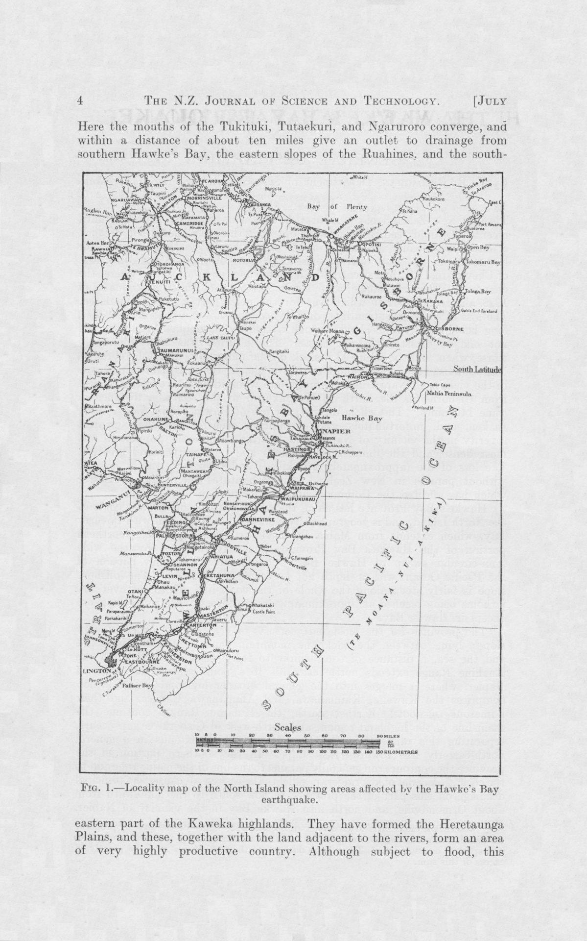
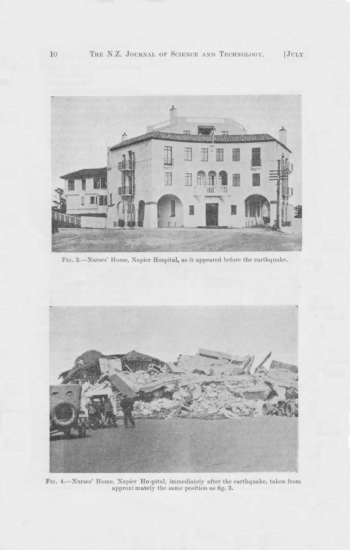
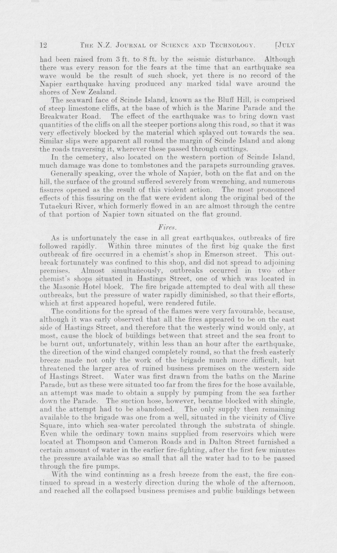
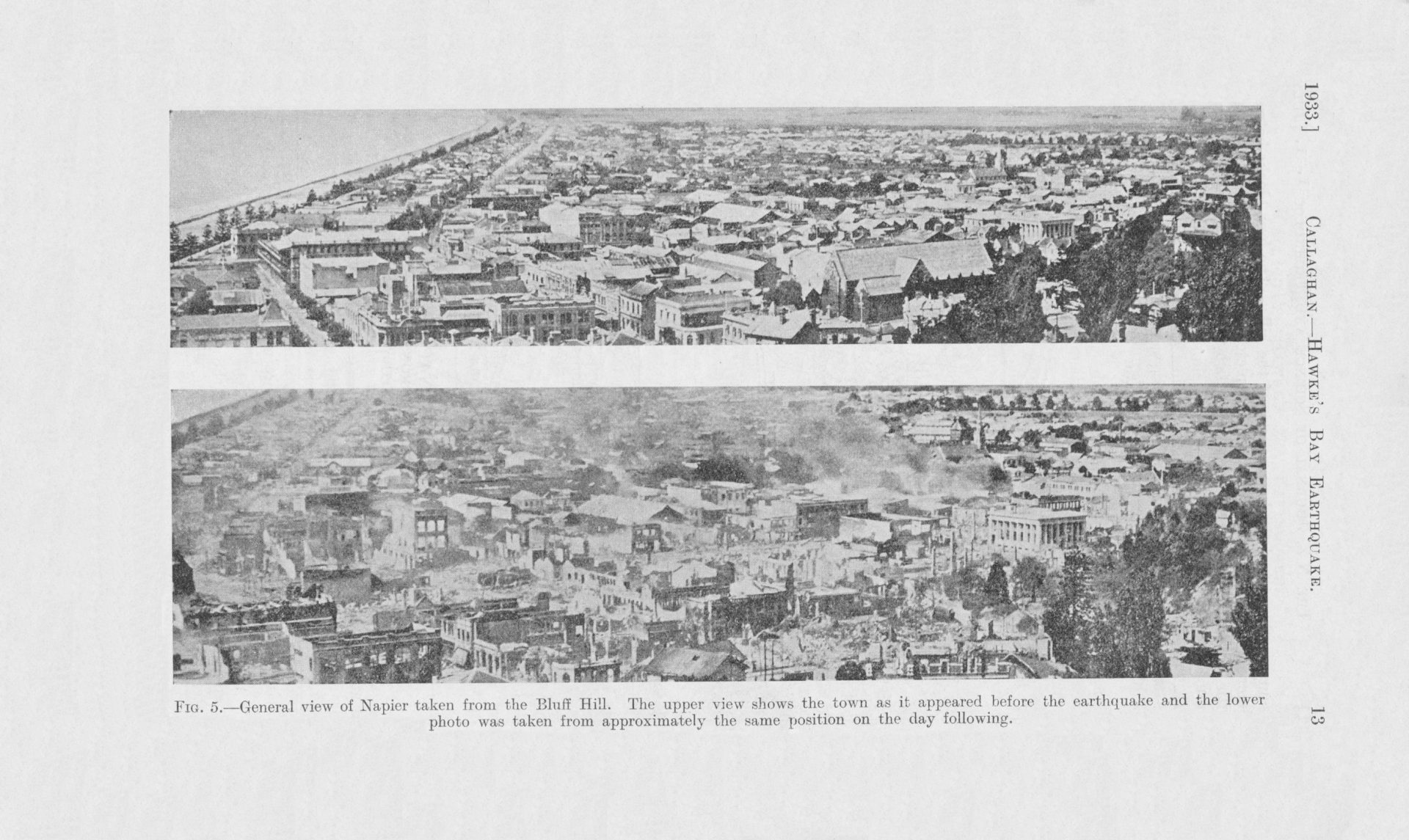
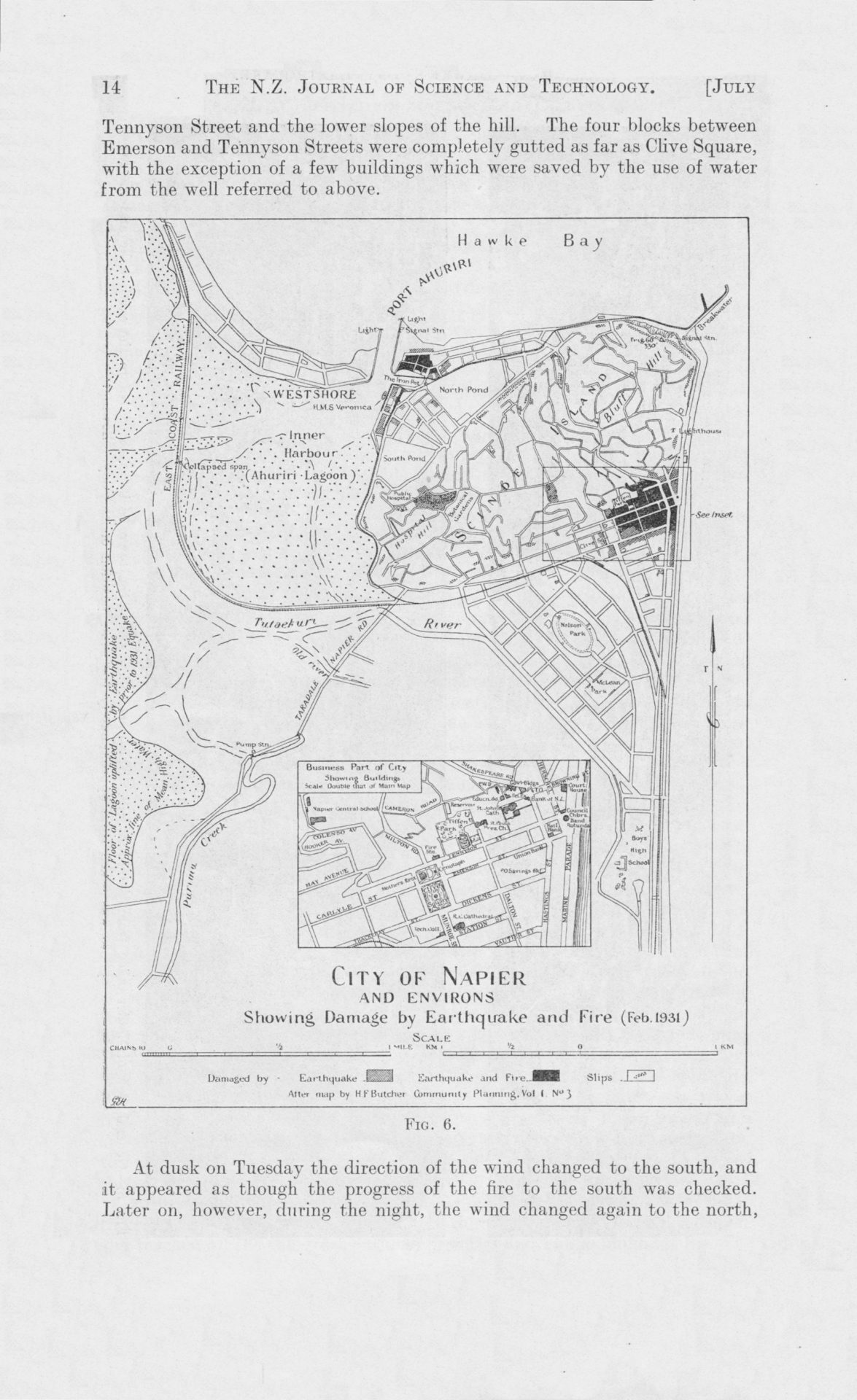
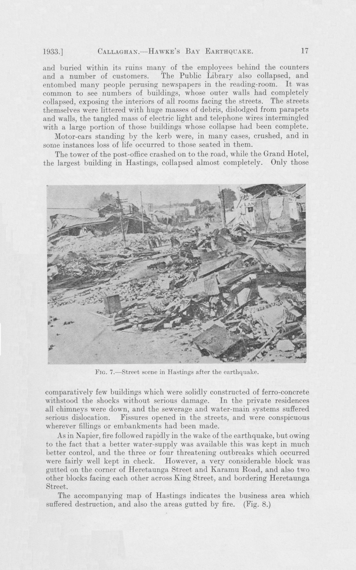
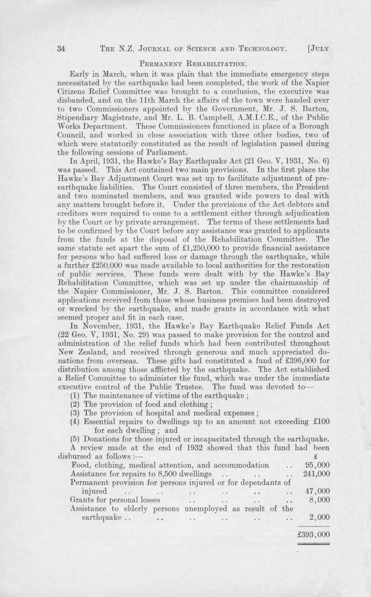
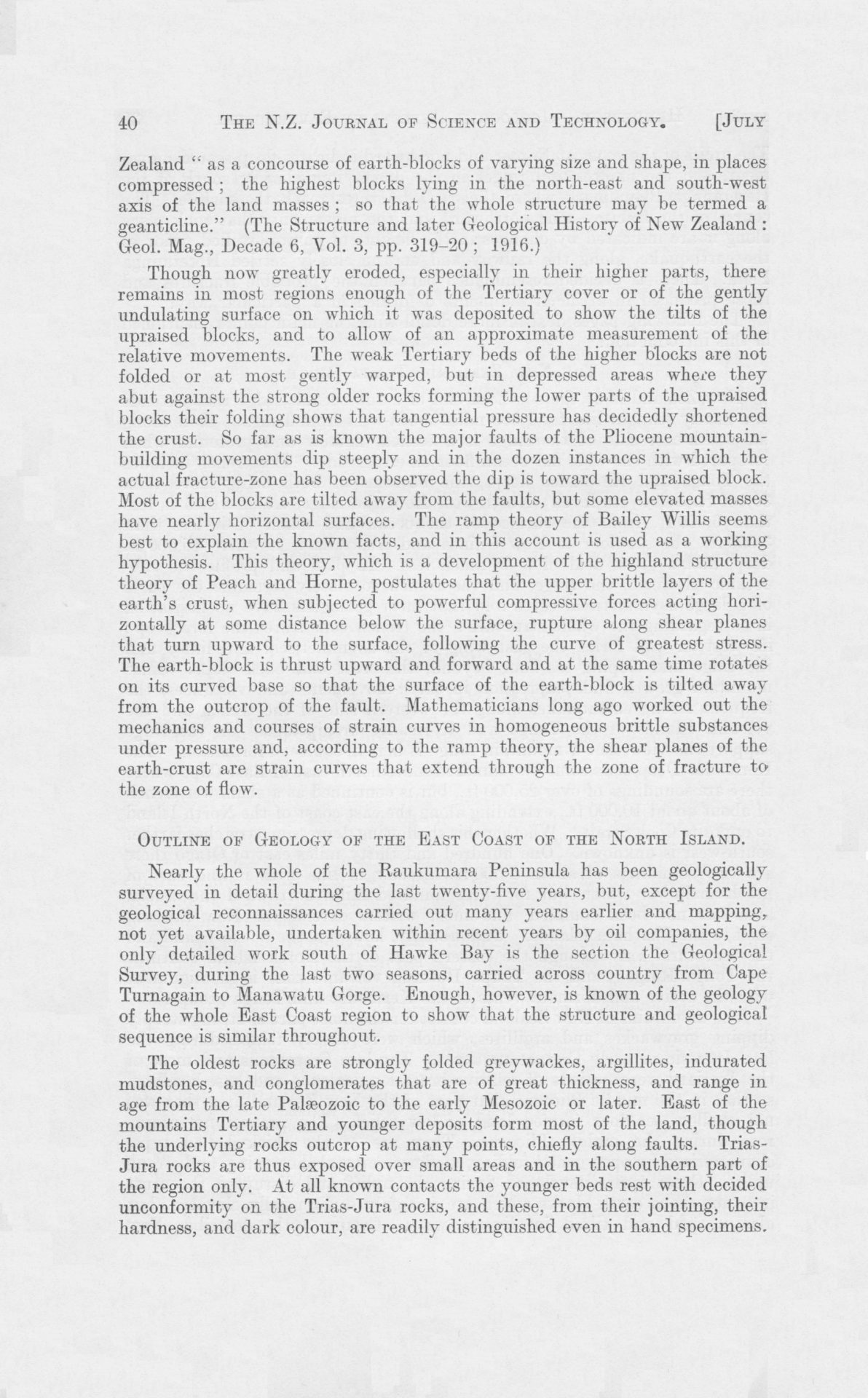
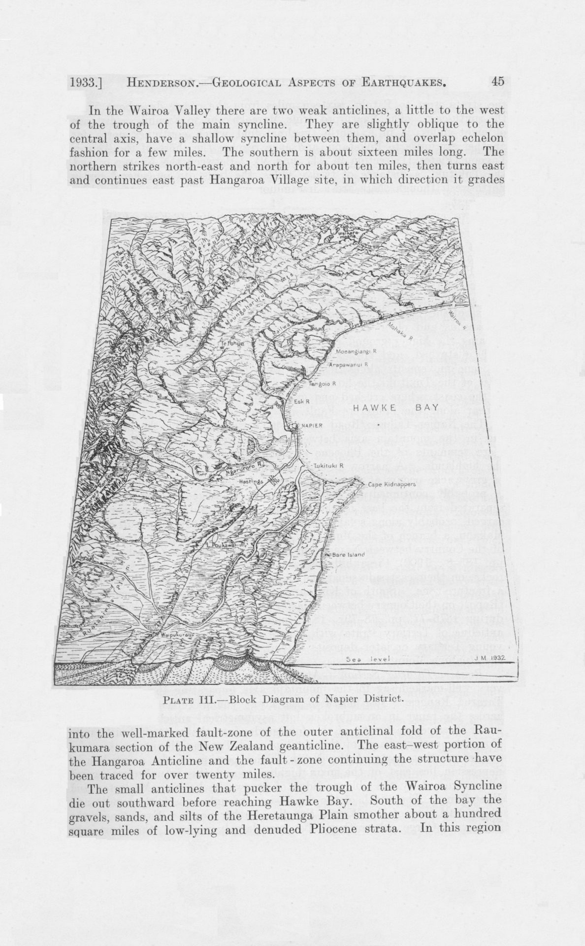
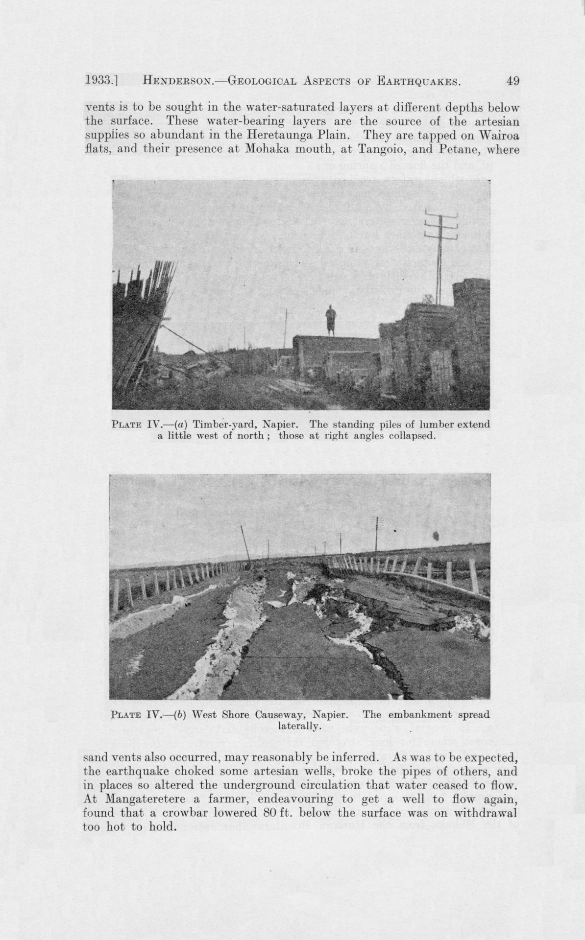
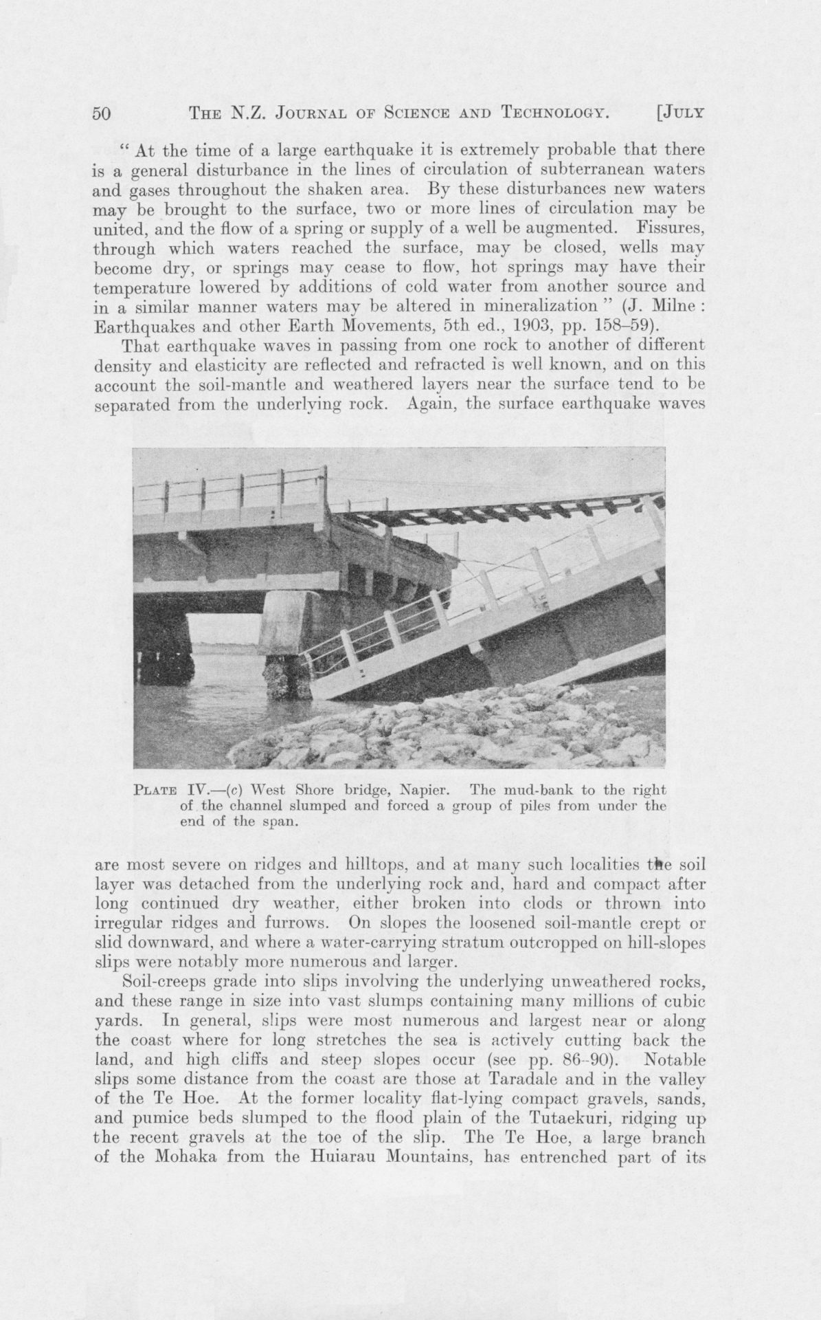
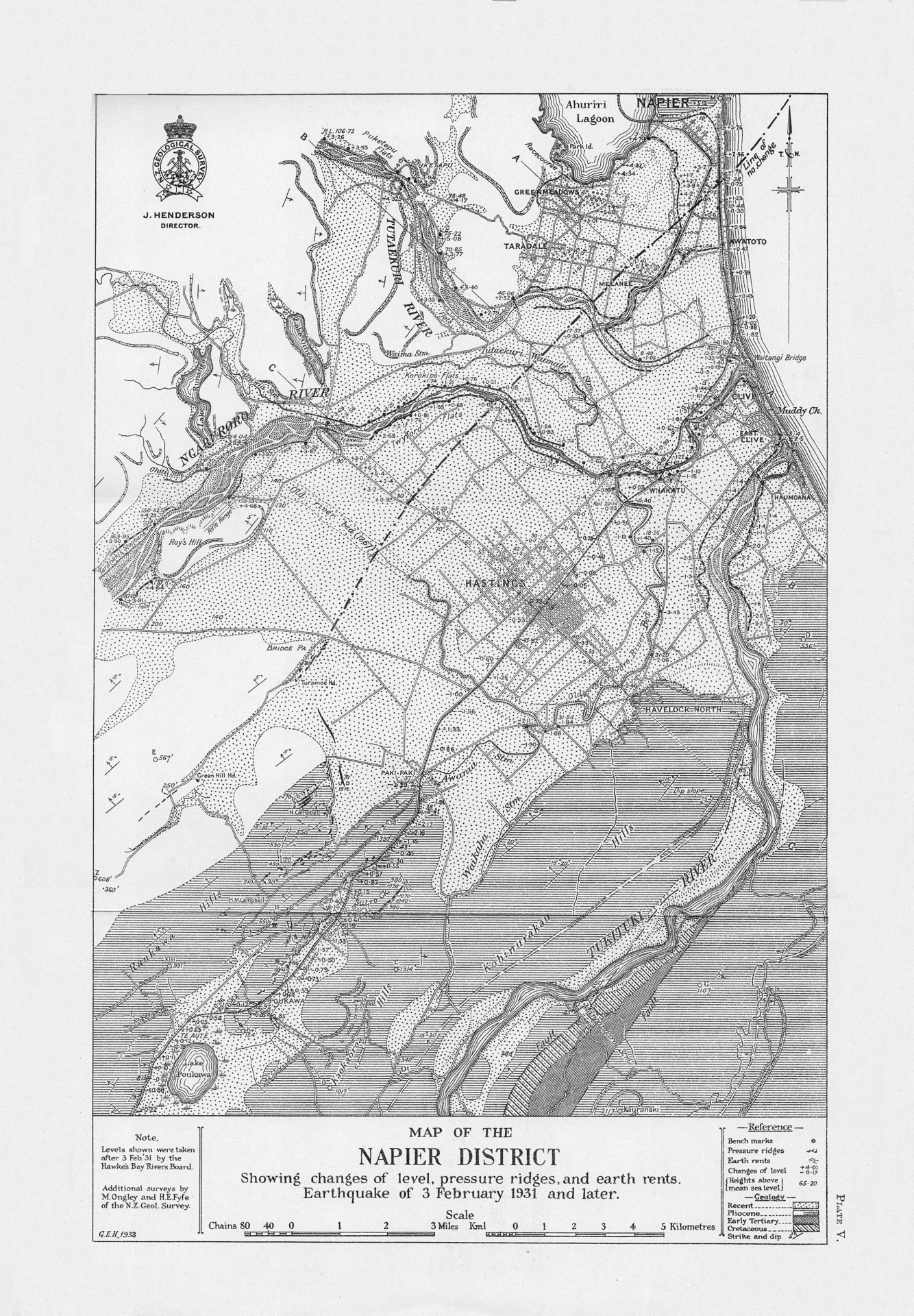
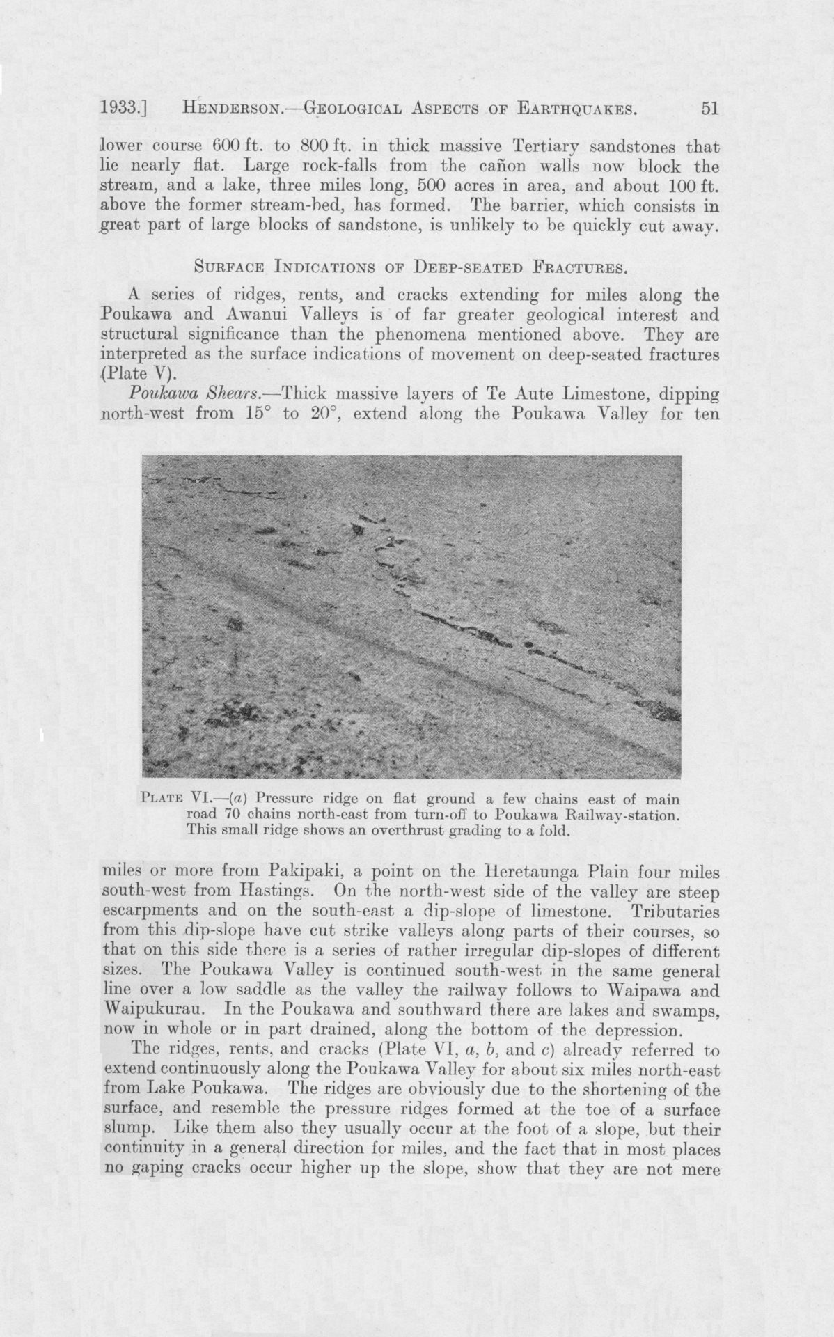
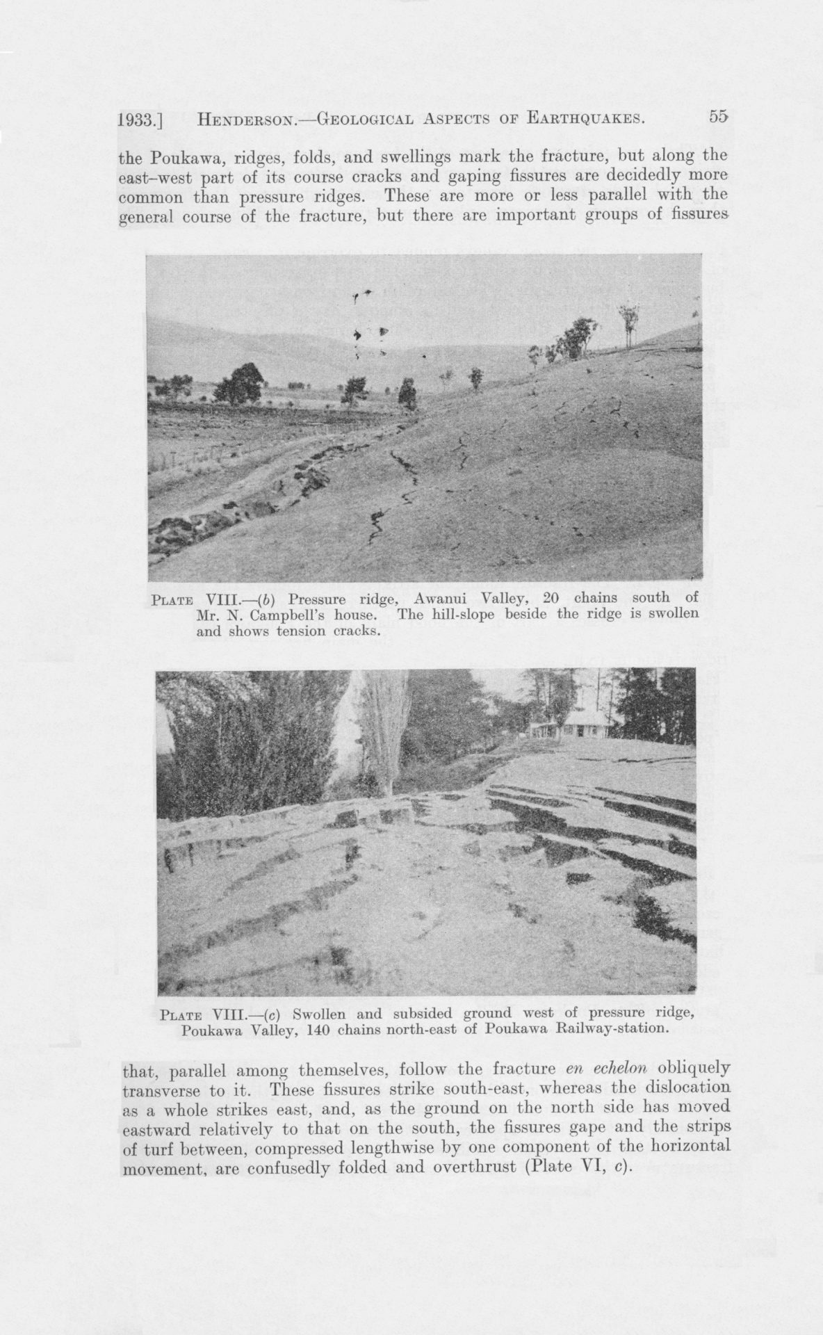
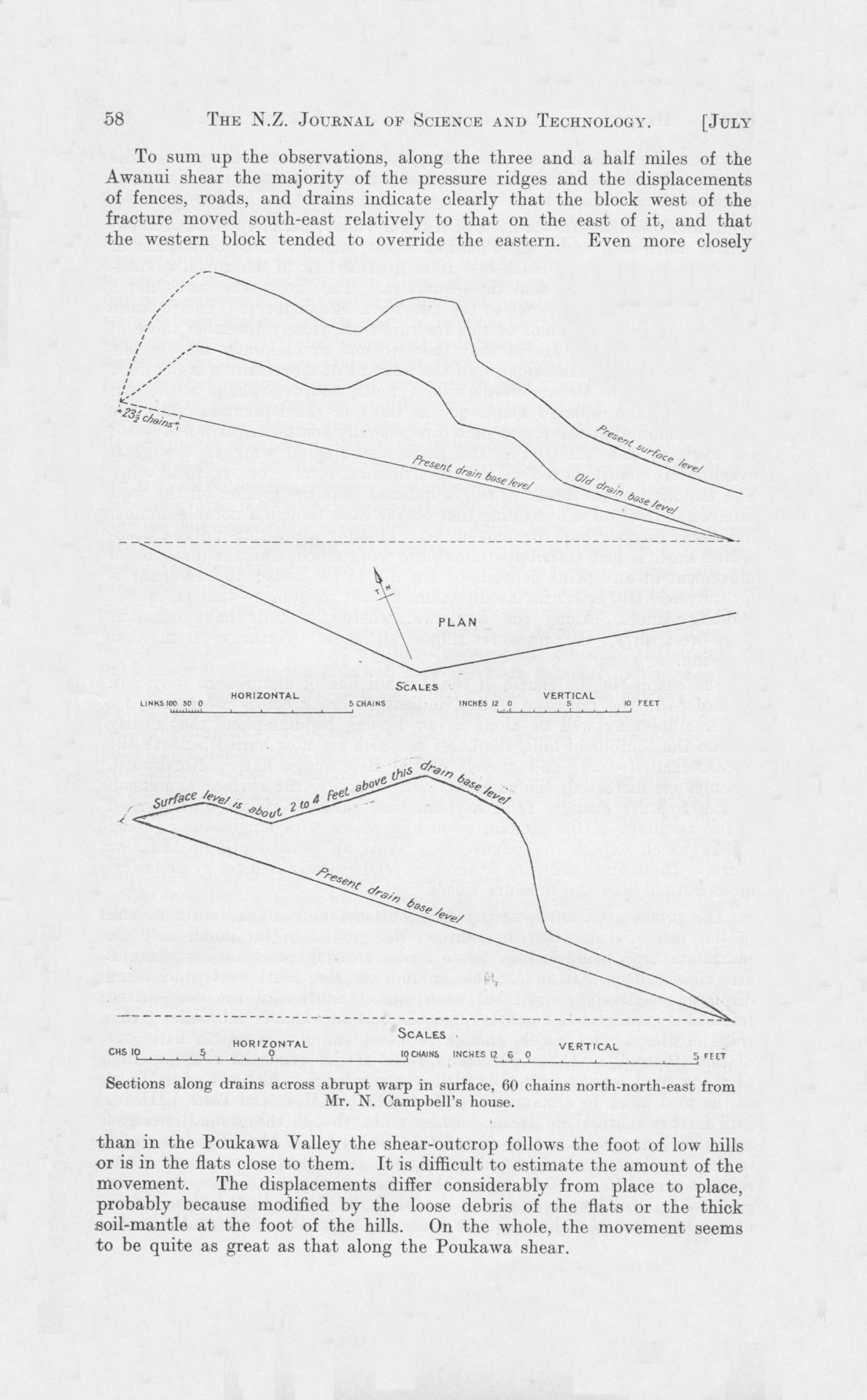
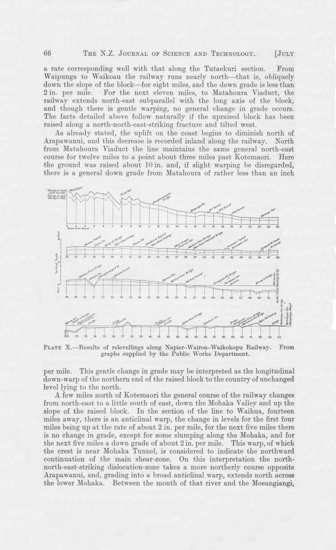
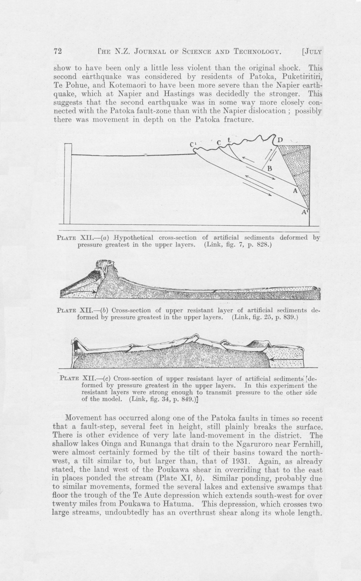
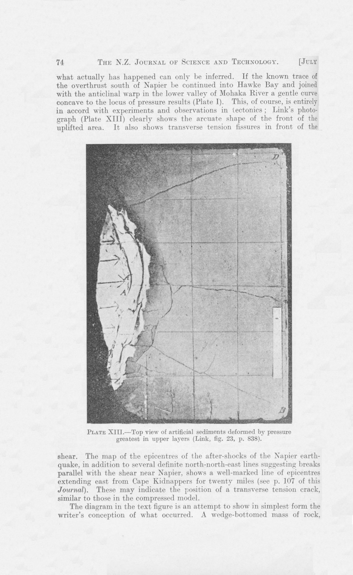
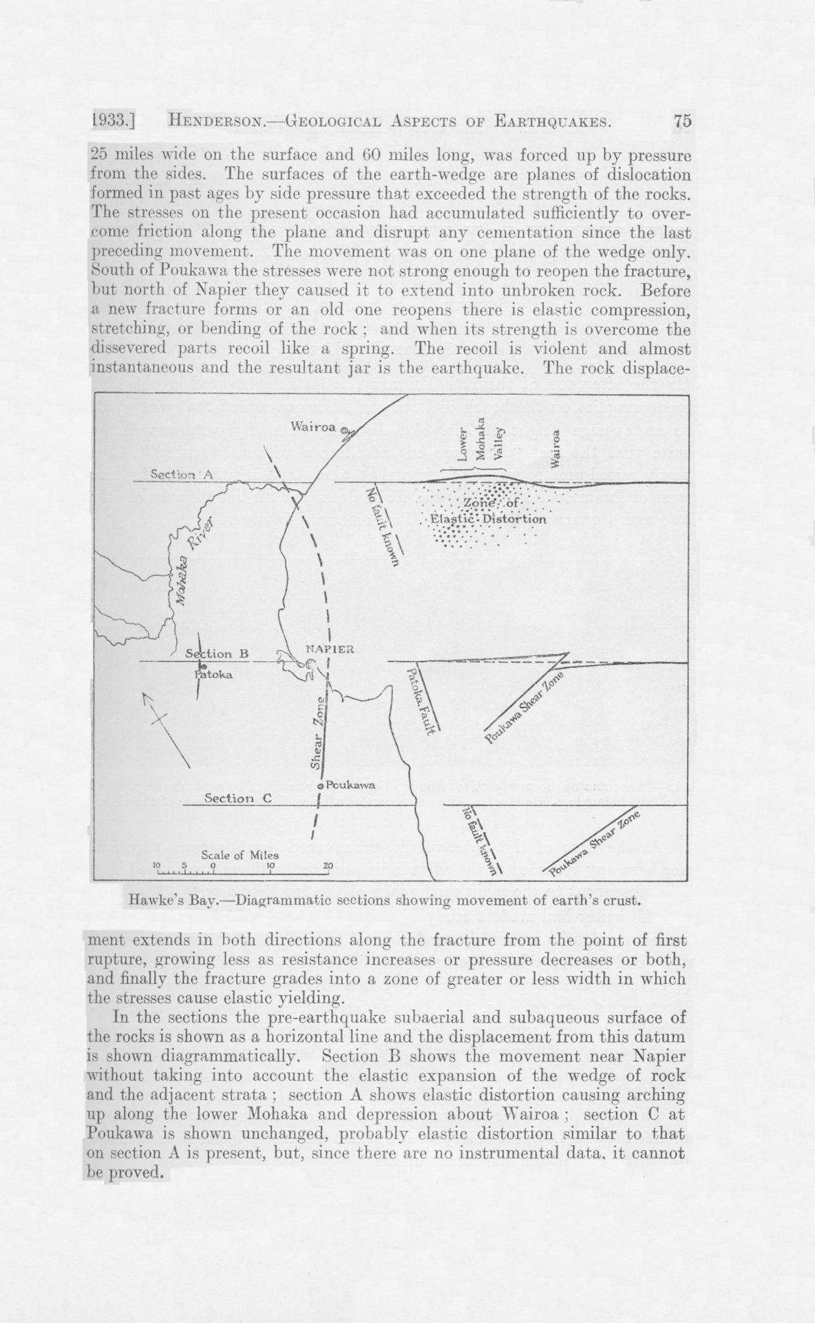
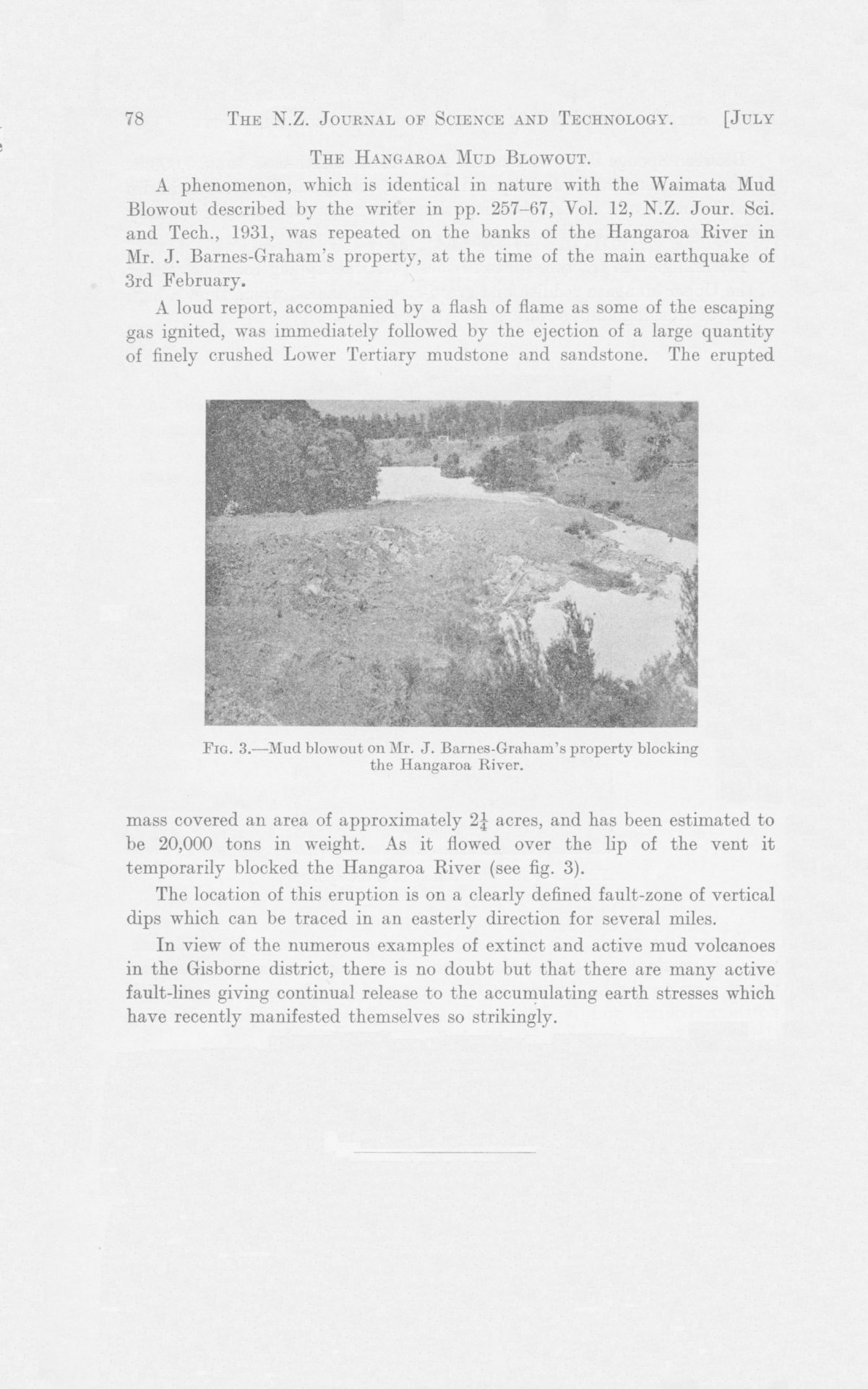
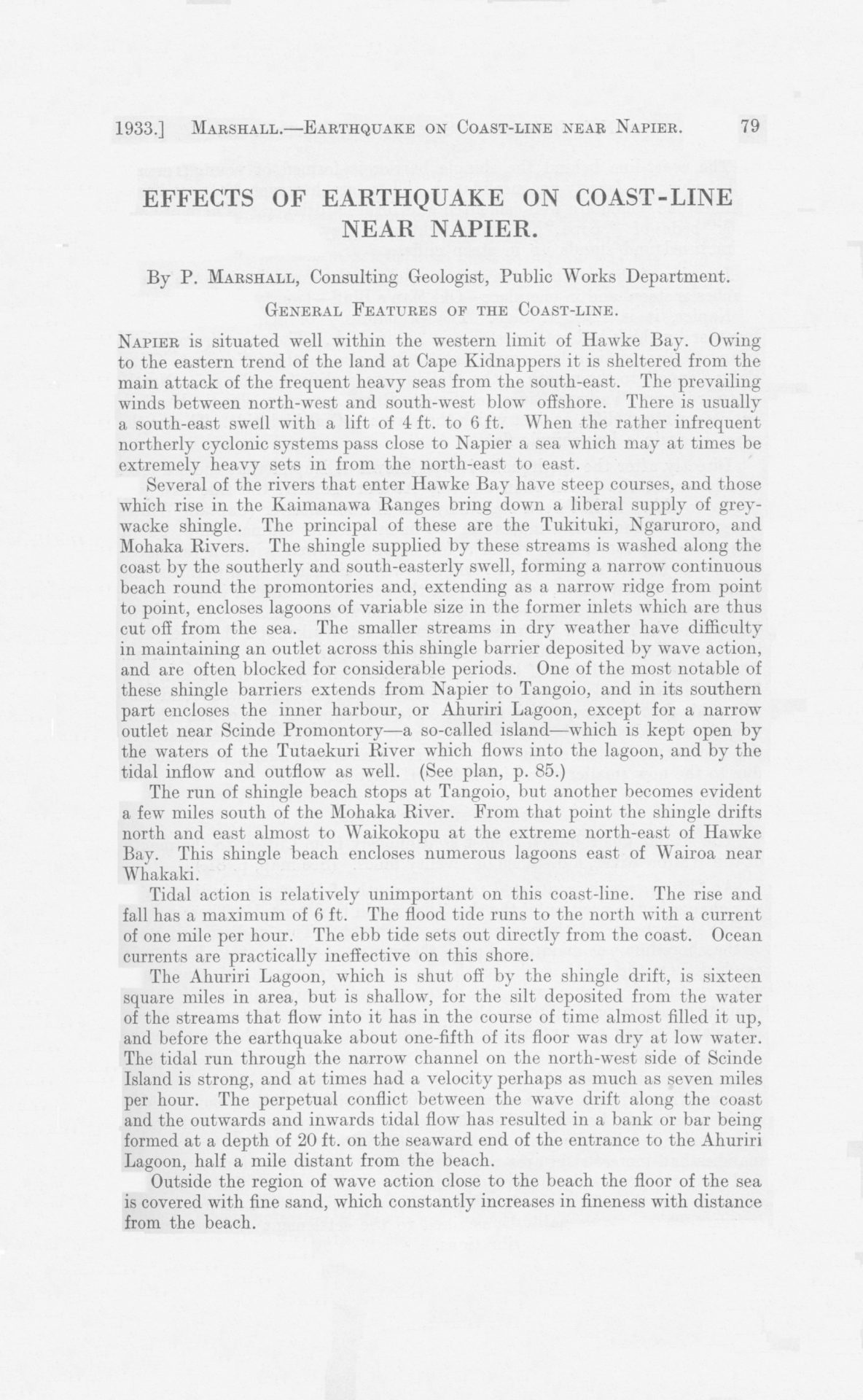
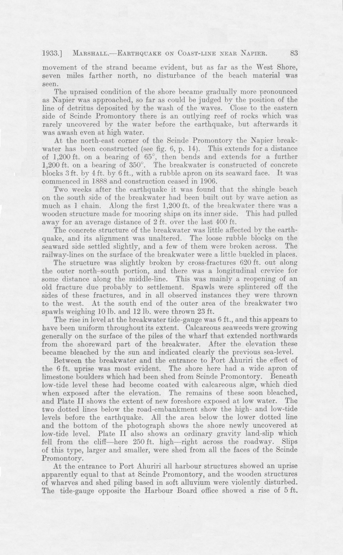
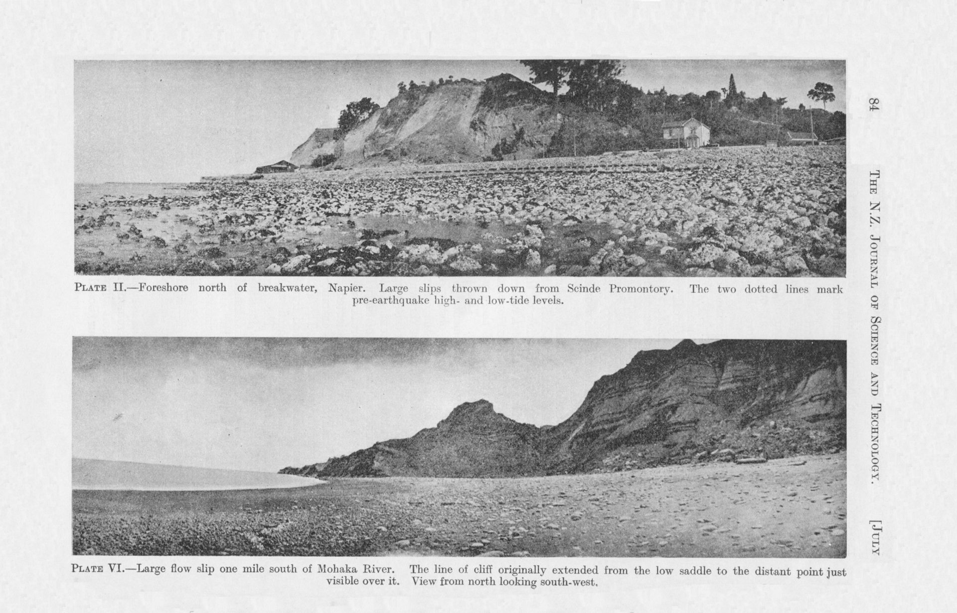
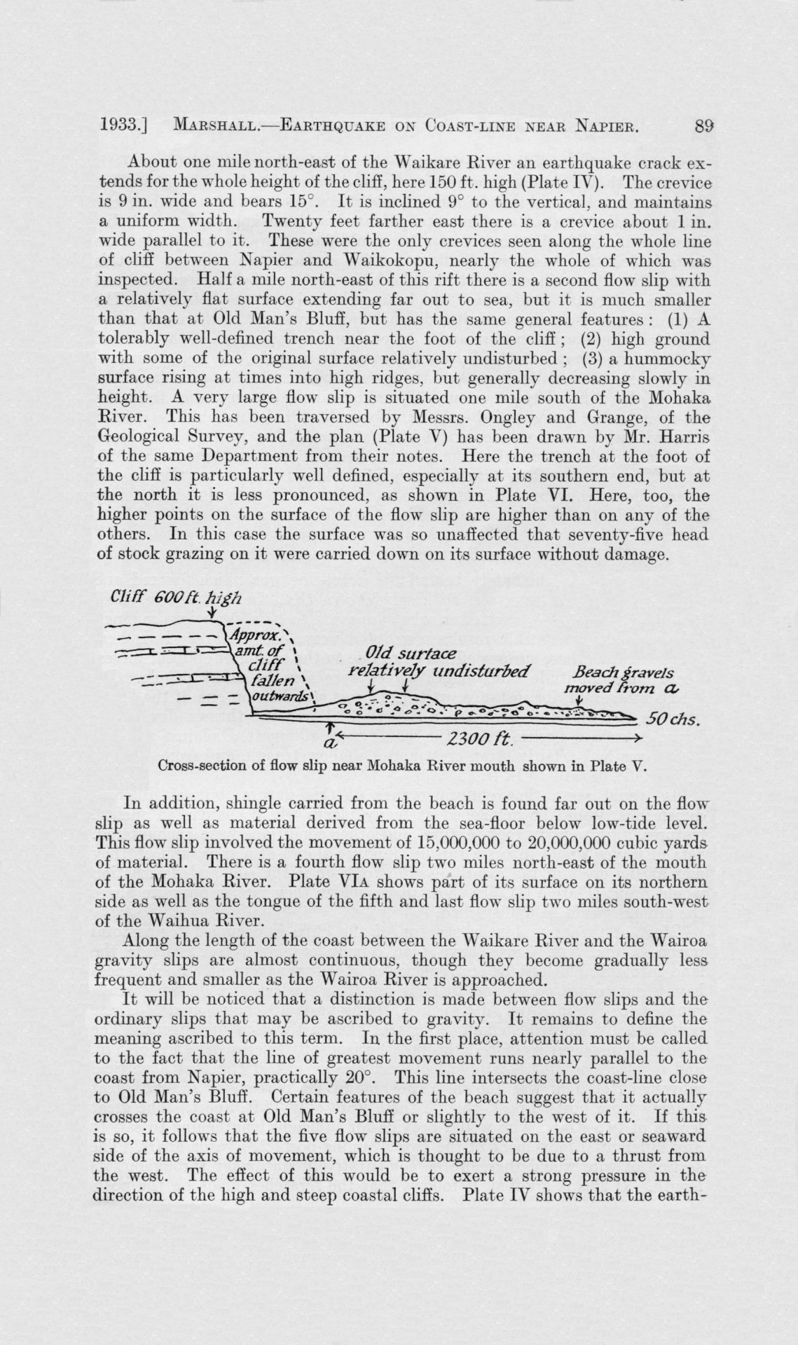
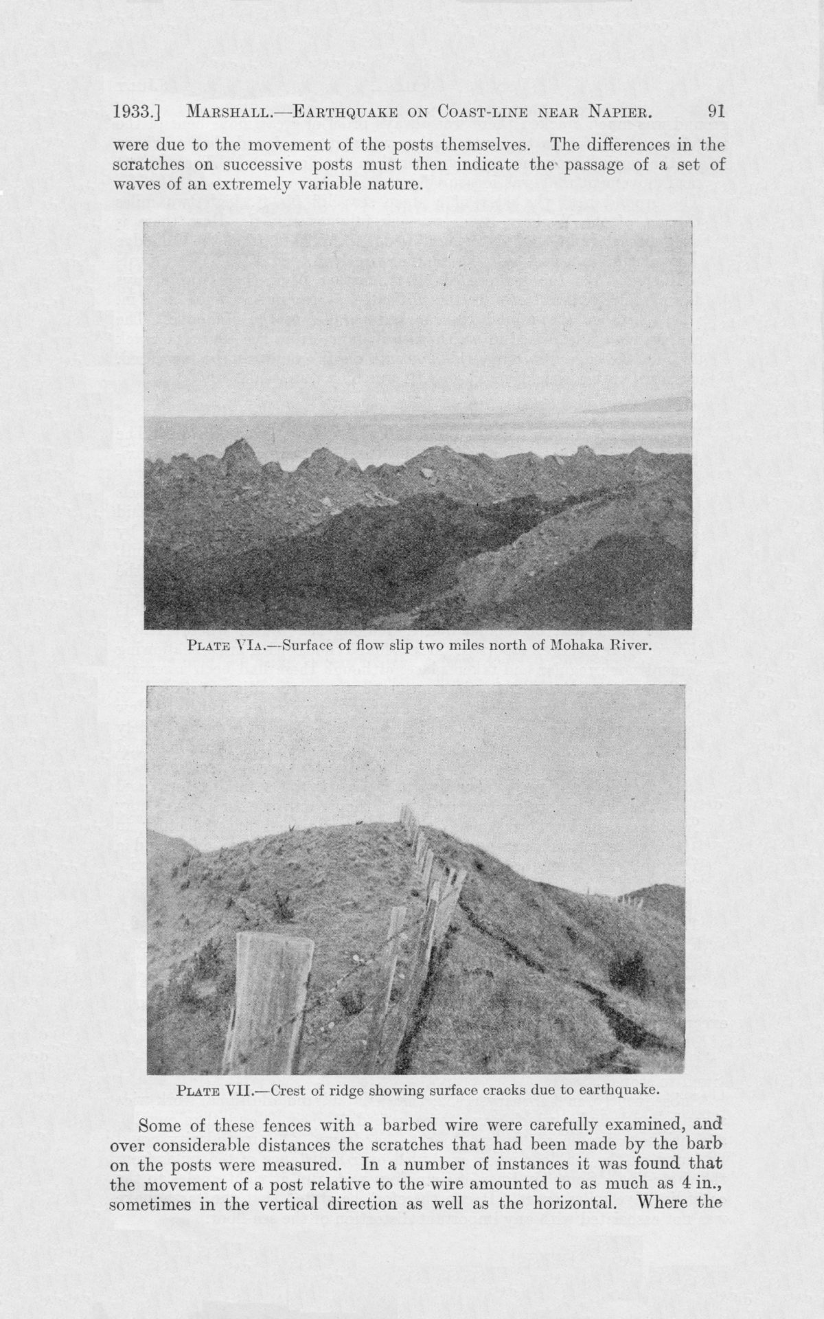
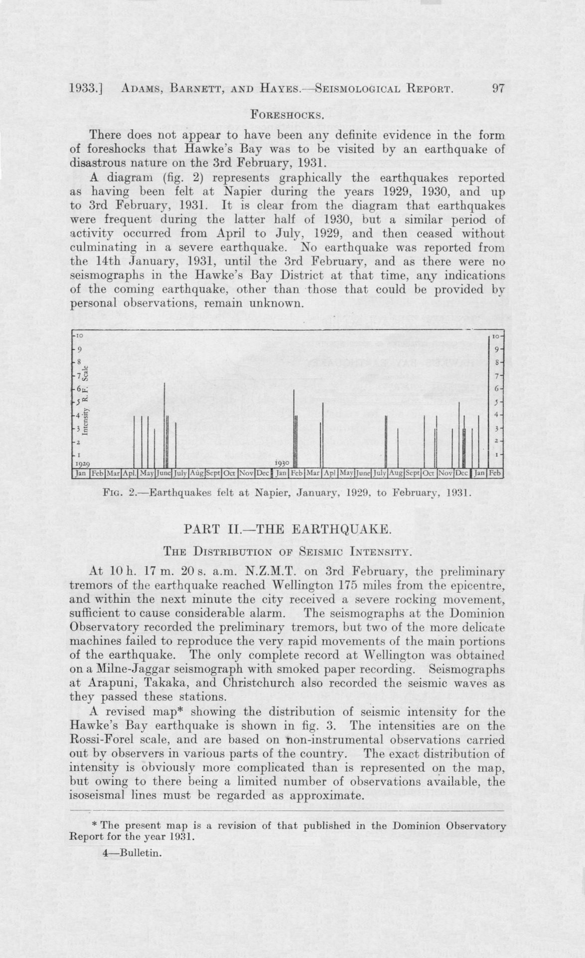
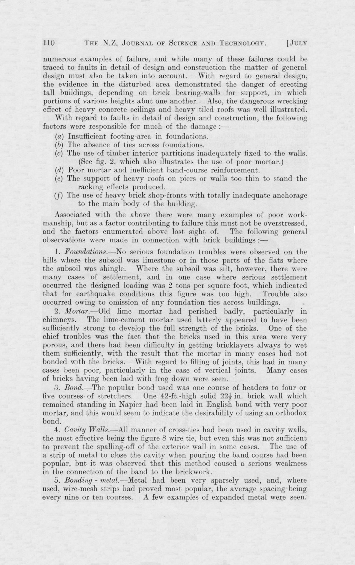
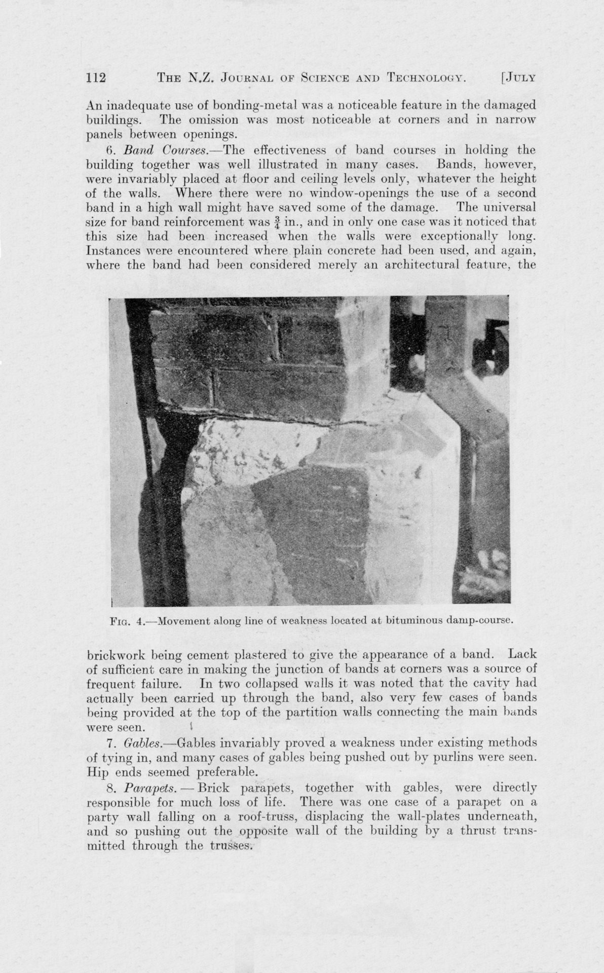
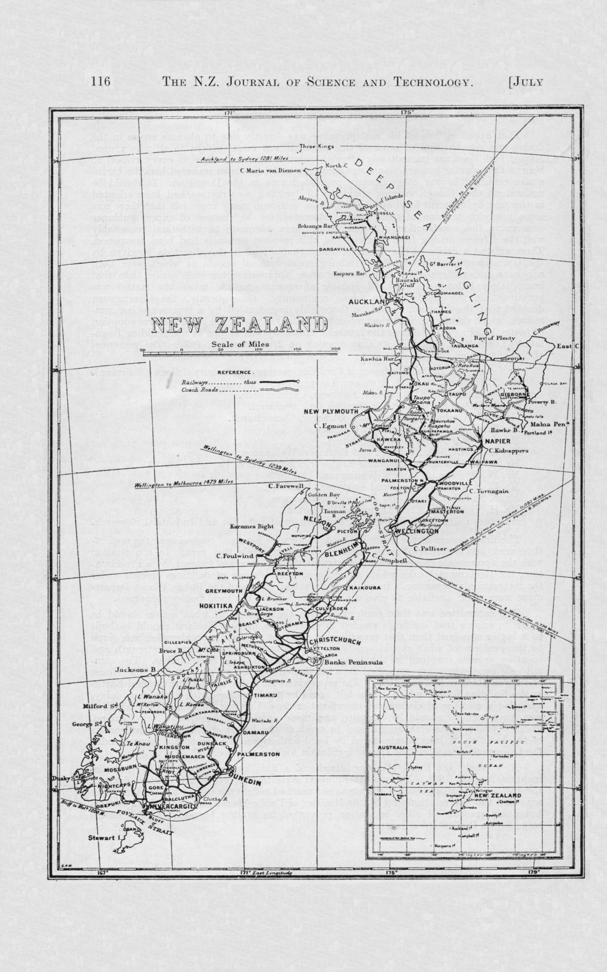
Original digital file
GroverP2081_EarthquakeReport.pdf
Non-commercial use

This work is licensed under a Attribution-NonCommercial 3.0 New Zealand (CC BY-NC 3.0 NZ).
Commercial Use
Please contact us for information about using this material commercially.Can you help?
The Hawke's Bay Knowledge Bank relies on donations to make this material available. Please consider making a donation towards preserving our local history.
Visit our donations page for more information.
Subjects
Tags
Business / Organisation
NZ Department of Scientific and Industrial ResearchFormat of the original
BookDate published
1933People
- C E Adams
- H F Baird
- W E Barnard
- Dr M A F Barnett
- J Barnes-Graham
- J S Barton
- Commodore Geoffrey Blake
- A Brodie
- J C Bryant
- H F Butcher
- F R Callaghan
- L B Campbell
- N Campbell
- R A Campbell
- Professor J E Cull
- J Fletcher
- G W Forbes
- R Girling-Butcher
- L I Grange
- J W Graham
- A G Harris
- G E Harris
- G A Hart
- W Harvey
- R C Hayes
- J Henderson
- Henry Hill
- G Hogben
- G H Loney
- E O Macpherson
- J T Mair
- E Mardsen
- P Marshall
- Dr J Marwick
- Honourable R Masters
- Alexander McKay
- A S Mitchell
- C O Morse
- W L Newnham
- M Ongley
- W M Page
- Honourable E A Ransom
- E H Rhodes
- S T Silver
- Sydney W S Strong
- H Vickerman
- J Vigor Brown
- H E Walshe
- W G Wohlmann
Accession number
431615Supporters and sponsors
We sincerely thank the following businesses and organisations for their support.


Do you know something about this record?
Please note we cannot verify the accuracy of any information posted by the community.